|
Niederheimbach
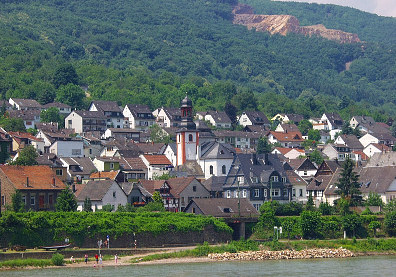
Niederheimbach () is an ''Ortsgemeinde'' – a municipality belonging to a ''Verbandsgemeinde'', a kind of collective municipality – in the Mainz-Bingen district in Rhineland-Palatinate, Germany. The winegrowing centre belongs to the ''Verbandsgemeinde'' of Rhein-Nahe, whose seat is in Bingen am Rhein, although that town is not within its bounds. Since 2003, Niederheimbach has been part of the Rhine Gorge UNESCO World Heritage Site. Geography Location Niederheimbach lies between Koblenz and Bingen, right on the Rhine Gorge, only a short way northwest of the Rhine Knee. The place, which is found beneath or east of Bingen Forest (''Binger Wald''), has a built-up area stretching from 80 to 140 m above sea level. The highest mountain in the municipal area, at 618 m above sea level, is the heavily wooded ''Franzosenkopf'' (“Frenchman’s Head”), found south of the built-up area in Bingen Forest. Politics Municipal council The council is made up of 13 council members ... [...More Info...] [...Related Items...] OR: [Wikipedia] [Google] [Baidu] |
Trechtingshausen
Trechtingshausen (formerly also ''Trechtlingshausen'') is an ''Ortsgemeinde'' – a municipality belonging to a ''Verbandsgemeinde'', a kind of collective municipality – in the Mainz-Bingen district in Rhineland-Palatinate, Germany. The winegrowing centre belongs to the ''Verbandsgemeinde'' of Rhein-Nahe, whose seat is in Bingen am Rhein, although that town is not within its bounds. Since 2003, Trechtingshausen has been part of the Rhine Gorge UNESCO World Heritage Site. Geography Location Trechtingshausen lies between Koblenz and Bingen right in the upper Rhine Gorge. It is found on the northeast slope of the Bingen Forest (''Binger Wald''). Near Trechtingshausen the Morgenbach flows into the Rhine. History The Chronicler told of the ''Castrum Trajani'' (“Trajan’s Castrum”) in Roman times. In Frankish times, Trechtingshausen belonged to the lower Nahegau (a county). Row graves from this time have been unearthed by building work. At the time of the municipality's ... [...More Info...] [...Related Items...] OR: [Wikipedia] [Google] [Baidu] |
Heimburg In Niederheimbach
The Heimburg (also known as ''Burg Hohneck'' or ''Burg Hoheneck'') is a castle in the village of Niederheimbach in Rhineland-Palatinate, Germany Germany, officially the Federal Republic of Germany, is a country in Central Europe. It lies between the Baltic Sea and the North Sea to the north and the Alps to the south. Its sixteen States of Germany, constituent states have a total popu .... Notes and references Sources and external links Castles in Rhineland-Palatinate Mainz-Bingen {{RhinelandPalatinate-struct-stub ... [...More Info...] [...Related Items...] OR: [Wikipedia] [Google] [Baidu] |
Burg Sooneck
Sooneck Castle () (also known as Saneck or Sonneck, previously also known as Schloss Sonneck) is a castle in the upper middle valley of the Rhine, in the Mainz-Bingen district of Rhineland-Palatinate, Germany. It is located near the village of Niederheimbach between Bingen am Rhein, Bingen and Bacharach. Since 2002, Sooneck Castle has been part of the Rhine Gorge UNESCO World Heritage Site. History Recent research has established that the castle was probably first mentioned in 1271. Like neighbouring Reichenstein Castle (Trechtingshausen), Reichenstein Castle, it was managed by the lords of Hohenfels Castle, Hohenfels as bailiffs for Kornelimünster Abbey near Aachen. What is certain is that the castle was Siege, besieged in 1282 by Rudolph I of Germany, King Rudolph I. His troops overran and destroyed the castle and the king imposed a ban on rebuilding it, which he explicitly restated in 1290. When the castle was rebuilt it was given to a family who were fervent supporters ... [...More Info...] [...Related Items...] OR: [Wikipedia] [Google] [Baidu] |
Wheel Of Mainz
The Wheel of Mainz or , in German language, German, was the coat of arms of the Archbishopric of Mainz and thus also of the Electorate of Mainz (Kurmainz), in Rhineland-Palatinate, Germany. It consists of a silver wheel with six spokes on a red background. The wheel can also be found in stonemasons' carvings (e.g. landmarks) and similar objects. Currently, the City of Mainz uses a double wheel connected by a silver cross. Origin The origins of the wheel are not known. One theory traces it back to Bishop Willigis, who was elected Archbishop of Mainz in 975. According to a tale delivered by the Brothers Grimm, his ancestors had been wheelwrights and his adversaries sneered at him for his mean birth. They drew wheels on the walls and doors of his residence, Willigis though made it his personal ensign with the motto "Willigis, remember where you came from". However, this is not proven, and in any case Coat of arms, coats of arms only appeared in the 12th century. Most of the archb ... [...More Info...] [...Related Items...] OR: [Wikipedia] [Google] [Baidu] |
Bingen Forest
The Bingen Forest () is part of the Hunsrück, a low mountain range in the Central Uplands of Germany. It is up to and is located in the state of Rhineland-Palatinate. Location The landscape of the Bingen Forest lies on the boundary of the counties of Mainz-Bingen (north to southeast), Bad Kreuznach (district), Bad Kreuznach (south) and Rhein-Hunsrück-Kreis (west). It is located between the northeastern end of the Hunsrück main ridge (northwest), the Rhine valley (north and northeast), behind which the Taunus rises, the Rhine Knee near Bingen am Rhein, Bingen (east) and the Soonwald (southwest). Flora The flora of the densely wooded Bingen Forest, about 40% of which consists of oak but otherwise is a mixed forest, covers an area of around 7,000 hectares, most of which comprises a contiguous area of woodland. History Tumulus, Barrows such as that southeast of Dichtelbach, castles and the present-day human settlement, settlements and villages are evidence that the Bi ... [...More Info...] [...Related Items...] OR: [Wikipedia] [Google] [Baidu] |
Mainz-Bingen
Mainz-Bingen is a district (''Kreis'') in the east of Rhineland-Palatinate, Germany. Neighboring districts are (from north clockwise) Rheingau-Taunus, the district-free cities Wiesbaden and Mainz, the districts Groß-Gerau, Alzey-Worms, Bad Kreuznach, and Rhein-Hunsrück. History During the French occupation under Napoleon the district was part of the department of Mont-Tonnerre. After the Congress of Vienna, the area north of the Nahe river went to the Prussian Rhine province, the biggest part however became part of the Grand Duchy of Hesse and was called Rhenish Hesse. In 1835 the Mainz district was created when the province Rheinhessen was abolished. In 1852 the Oppenheim district was created, and took some of the area of the Mainz district; in 1938 this district was abolished again. The current area of the district was formed in 1969, when the districts of Mainz and Bingen were merged. Geography The main river in the district is the Rhine, which marks the border of the distr ... [...More Info...] [...Related Items...] OR: [Wikipedia] [Google] [Baidu] |
Rhein-Nahe
Rhein-Nahe is a ''Verbandsgemeinde'' ("collective municipality") in the district Mainz-Bingen, in Rhineland-Palatinate, Germany. It is situated along the left bank of the Rhine The Rhine ( ) is one of the List of rivers of Europe, major rivers in Europe. The river begins in the Swiss canton of Graubünden in the southeastern Swiss Alps. It forms part of the Swiss-Liechtenstein border, then part of the Austria–Swit ..., north of Bingen. Bingen is the seat of the municipality, but not part of it. The ''Verbandsgemeinde'' Rhein-Nahe consists of the following ''Ortsgemeinden'' ("local municipalities"): * Bacharach * Breitscheid * Manubach * Münster-Sarmsheim * Niederheimbach * Oberdiebach * Oberheimbach * Trechtingshausen * Waldalgesheim * Weiler bei Bingen {{Authority control Verbandsgemeinden in Rhineland-Palatinate ... [...More Info...] [...Related Items...] OR: [Wikipedia] [Google] [Baidu] |
Champtoceaux
Champtoceaux () is a former commune in the Maine-et-Loire department of western France. On 15 December 2015, it was merged into the new commune Orée-d'Anjou. , 25 November 2015 History Champtoceaux name derives from Latin ''Castrum Sellense''. Inhabitants are called ''Castrocelsiens'' today.Twin towns * Verwoodin , |
Municipalities Of Germany
MunicipalitiesCountry Compendium. A companion to the English Style Guide European Commission, May 2021, pages 58–59. (, ; singular ) are the lowest level of official territorial division in . This can be the second, third, fourth or fifth level of territorial division, depending on the status of the municipality and the '''' (federal state) it is part of. The city-states Berlin, Brem ... [...More Info...] [...Related Items...] OR: [Wikipedia] [Google] [Baidu] |
Coat Of Arms
A coat of arms is a heraldry, heraldic communication design, visual design on an escutcheon (heraldry), escutcheon (i.e., shield), surcoat, or tabard (the last two being outer garments), originating in Europe. The coat of arms on an escutcheon forms the central element of the full achievement (heraldry), heraldic achievement, which in its whole consists of a shield, supporters, a crest (heraldry), crest, and a motto. A coat of arms is traditionally unique to the armiger (e.g. an individual person, family, state, organization, school or corporation). The term "coat of arms" itself, describing in modern times just the heraldic design, originates from the description of the entire medieval chainmail "surcoat" garment used in combat or preparation for the latter. Roll of arms, Rolls of arms are collections of many coats of arms, and since the early Modern Age centuries, they have been a source of information for public showing and tracing the membership of a nobility, noble family, a ... [...More Info...] [...Related Items...] OR: [Wikipedia] [Google] [Baidu] |
Bunch Of Grapes
In viticulture, the grape cluster (also bunch of grapes) is a fertilized inflorescence of the grapevine, the primary part of this plant used for food (grape leaves are also used in some culinary traditions). The size of the grape bunch greatly varies, from few grams to kilograms, depending on the grape variety and conditions during the fruit set. Architecture The placement of a cluster on the vine is similar to that of a tendril, as both develop from the same uncommitted primordia, the ''anlagen''. The grape bunch position on the side of the stem opposing a leaf is unusual for inflorescence of the plants. The typical shape of a cluster depends on the grape variety. The bunch of grapes, like a tendril, has two ''arms''. The inner arm develops into a full-grown cluster, the smaller outer one might die off, develop into a small tendril-like arm with no fruit, or form a large "wing" with berries that sometimes ripen differently than the ones of the main cluster (for example, in Tr ... [...More Info...] [...Related Items...] OR: [Wikipedia] [Google] [Baidu] |
Kath
{{disambiguation, callsign ...
Kath or KATH may refer to: * Kath (city), the historical capital of Khwarezm * Kath (name), a list of people and fictional characters with the given name or surname * KATH-TV, the NBC TV station in Juneau, Alaska * KATH (AM), a radio station in Texas * Ethan Kath, a Canadian musician See also * Cath (other) * Kathi (other) Kathi may refer to: * a short form of Kathleen (other) * Kathiawari (horse) or Kathi, a horse breed from Kathiawar in Gujarat, India * Kathi caste, a caste of Kathiawar in Gujarat, India * a former small princely state part of the Mewas S ... [...More Info...] [...Related Items...] OR: [Wikipedia] [Google] [Baidu] |


