|
New Caledonia Trough
The New Caledonia Trough is an ocean floor feature that extends from the north of the island of Grande Terre (New Caledonia), Grande Terre of New Caledonia, to the coast off the Taranaki region of the North Island of New Zealand. Its southern portion includes the Taranaki Basin which has demonstrated oil reserves. Geography The Trough (geology), trough is long and at ocean depths between orientated initially under the southern Coral Sea northeast to southwest similar to the alignment of Grande Terre but at the southern end of Grande Terre strikes north–south. At about 33°S the strike turns south-west towards northern Taranaki. These have been termed the northern (18–23°S), central (23–33°S) and southern (33–37°S) sectors. The northern and central portions are often termed the New Caledonia Basin. It extends from to A clear distinction between the trough and its constituent basins was only defined in 2012. The eastern boundary of the northern sector is the Fairwa ... [...More Info...] [...Related Items...] OR: [Wikipedia] [Google] [Baidu] |
Grande Terre (New Caledonia)
Grande Terre () is the largest and principal island of New Caledonia, which is a territory of France. History Until about 37 million years ago, the island was completely submerged under the ocean. British explorer James Cook sighted Grande Terre in 1774 and named it "New Caledonia", Caledonia being the Latin name for what is now Scotland. The island's mountains reminded him of Scotland. Eventually, the name "New Caledonia" became applied to Grande Terre and its surrounding islands. It was annexed by the French Empire and became a penal colony in 1853. Today, Grande Terre has about 268,000 residents. Geography The largest settlement on Grande Terre is Nouméa, the capital city of New Caledonia. Locals refer to Grande Terre as "Le Caillou", the pebble. The island has a fairly hot and humid climate, though varying as the south-east trade winds bring relatively cool air. Surrounding the island and especially to the north-west is the New Caledonian barrier reef. The island is ... [...More Info...] [...Related Items...] OR: [Wikipedia] [Google] [Baidu] |
Challenger Plateau
The Challenger Plateau is a large submarine plateau west of New Zealand and south of the Lord Howe Rise. It has an approximate diameter of and an area of about . The water depth over the plateau varies between to and is covered by up to of sedimentary rocks of Upper Cretaceous to recent in age. The plateau originated in the Gondwanan breakup and is one of the five major submerged parts of Zealandia, a largely submerged continent A continent is any of several large geographical regions. Continents are generally identified by convention (norm), convention rather than any strict criteria. A continent could be a single large landmass, a part of a very large landmass, as .... References Geography of the New Zealand seabed Plateaus of the Pacific Ocean Zealandia {{marine-geo-stub ... [...More Info...] [...Related Items...] OR: [Wikipedia] [Google] [Baidu] |
Geology Of New Caledonia
The geology of New Caledonia includes all major rock types (igneous rock, igneous, Sedimentary rock, sedimentary, and Metamorphic rock, metamorphic), which here range in age from ~290 million years old (Ma) to recent. Their formation is driven by alternate plate collisions and rifting. The Mantle (geology), mantle-derived Eocene Peridotite Nappe is the most significant and widespread unit (labelled as "Ophiolites" and coloured in bright green in Fig. 1). The igneous unit consists of ore-rich ultramafic rocks Thrust fault, thrust onto the main island. Mining of valuable metals from this unit has been an economical pillar of New Caledonia for more than a century. New Caledonia is located on the Indo-Australian Plate and the largely submerged continent of Zealandia. After New Zealand, it is the second-largest subaerial landmass, and the northernmost part of this continent. As shown on the map, the landmass is elongated in a NW-SE orientation, which is similar to the distribution patte ... [...More Info...] [...Related Items...] OR: [Wikipedia] [Google] [Baidu] |
Geology Of New Zealand
The geology of New Zealand is noted for its volcanic activity, earthquakes and Geothermal areas in New Zealand, geothermal areas because of its position on the boundary of the Australian Plate and Pacific Plates. New Zealand is part of Zealandia, a microcontinent nearly half the size of Australia that broke away from the Gondwanan supercontinent about 83 million years ago. New Zealand's early separation from other landmasses and subsequent evolution have created a unique fossil record and modern Environment of New Zealand, ecology. New Zealand's geology can be simplified into three phases. First the basement rocks of New Zealand formed. These rocks were once part of the super-continent of Gondwana, along with South America, Africa, Madagascar, India, Antarctica and Australia. The rocks that now form the mostly submerged continent of Zealandia were then nestled between Eastern Australia and Western Antarctica. Secondly New Zealand drifted away from Gondwana and many sedimentary ... [...More Info...] [...Related Items...] OR: [Wikipedia] [Google] [Baidu] |
Back-arc Basin
A back-arc basin is a type of geologic Structural basin, basin, found at some convergent boundary, convergent plate boundaries. Presently all back-arc basins are submarine features associated with island arcs and subduction zones, with many found in the western Pacific Ocean. Most of them result from Tension (physics), tensional forces, caused by a process known as Oceanic trench#Trench rollback, oceanic trench rollback, where a subduction zone moves towards the subducting plate. Back-arc basins were initially an unexpected phenomenon in plate tectonics, as convergent boundaries were expected to universally be zones of compression. However, in 1970, Dan Karig published a model of back-arc basins consistent with plate tectonics. Structural characteristics Back-arc basins are typically very long and relatively narrow, often thousands of kilometers long while only being a few hundred kilometers wide at most. For back-arc extension to form, a subduction zone is required, but not a ... [...More Info...] [...Related Items...] OR: [Wikipedia] [Google] [Baidu] |
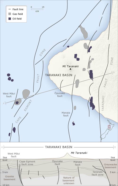
Map And Cross Section Of Taranaki Basin
A map is a symbolic depiction of interrelationships, commonly spatial, between things within a space. A map may be annotated with text and graphics. Like any graphic, a map may be fixed to paper or other durable media, or may be displayed on a transitory medium such as a computer screen. Some maps change interactively. Although maps are commonly used to depict geographic elements, they may represent any space, real or fictional. The subject being mapped may be two-dimensional such as Earth's surface, three-dimensional such as Earth's interior, or from an abstract space of any dimension. Maps of geographic territory have a very long tradition and have existed from ancient times. The word "map" comes from the , wherein ''mappa'' meant 'napkin' or 'cloth' and ''mundi'' 'of the world'. Thus, "map" became a shortened term referring to a flat representation of Earth's surface. History Maps have been one of the most important human inventions for millennia, allowing humans t ... [...More Info...] [...Related Items...] OR: [Wikipedia] [Google] [Baidu] |
Australian Plate
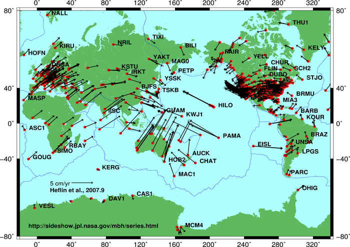
The Australian plate is or was a major tectonic plate in the eastern and, largely, southern hemispheres. Originally a part of the ancient continent of Gondwana, Australia remained connected to India and Antarctica until approximately when India broke away and began moving north. Australia and Antarctica had begun rifting by and completely separated a while after this, some believing as recently as , but most accepting presently that this had occurred by . The Australian plate later fused with the adjacent Indian plate beneath the Indian Ocean to form a single Indo-Australian plate. However, recent studies suggest that the two plates may have once again split apart and have been separate plates for at least 3 million years. The Australian plate includes the continent of Australia, including Tasmania, as well as portions of New Guinea, New Zealand and the Indian Ocean basin. Scope The continental crust of this plate covers the whole of Australia, the Gulf of Carpentaria, sou ... [...More Info...] [...Related Items...] OR: [Wikipedia] [Google] [Baidu] |
Mohorovičić Discontinuity
The Mohorovičić discontinuity ( ; )usually called the Moho discontinuity, Moho boundary, or just Mohois the boundary between the Earth's crust, crust and the Earth's mantle, mantle of Earth. It is defined by the distinct change in velocity of seismic waves as they pass through changing densities of rock. The Moho lies almost entirely within the lithosphere (the hard outer layer of the Earth, including the crust). Only beneath mid-ocean ridges does it define the lithosphere–asthenosphere boundary (the depth at which the mantle becomes significantly ductile). The Mohorovičić discontinuity is below the ocean floor, and beneath typical continental crusts, with an average of . Named after the pioneering Croats, Croatian seismologist Andrija Mohorovičić, the Moho separates both the oceanic crust and continental crust from the underlying mantle. The Mohorovičić discontinuity was first identified in 1909 by Mohorovičić, when he observed that seismograms from Depth of focus ... [...More Info...] [...Related Items...] OR: [Wikipedia] [Google] [Baidu] |
Oligocene
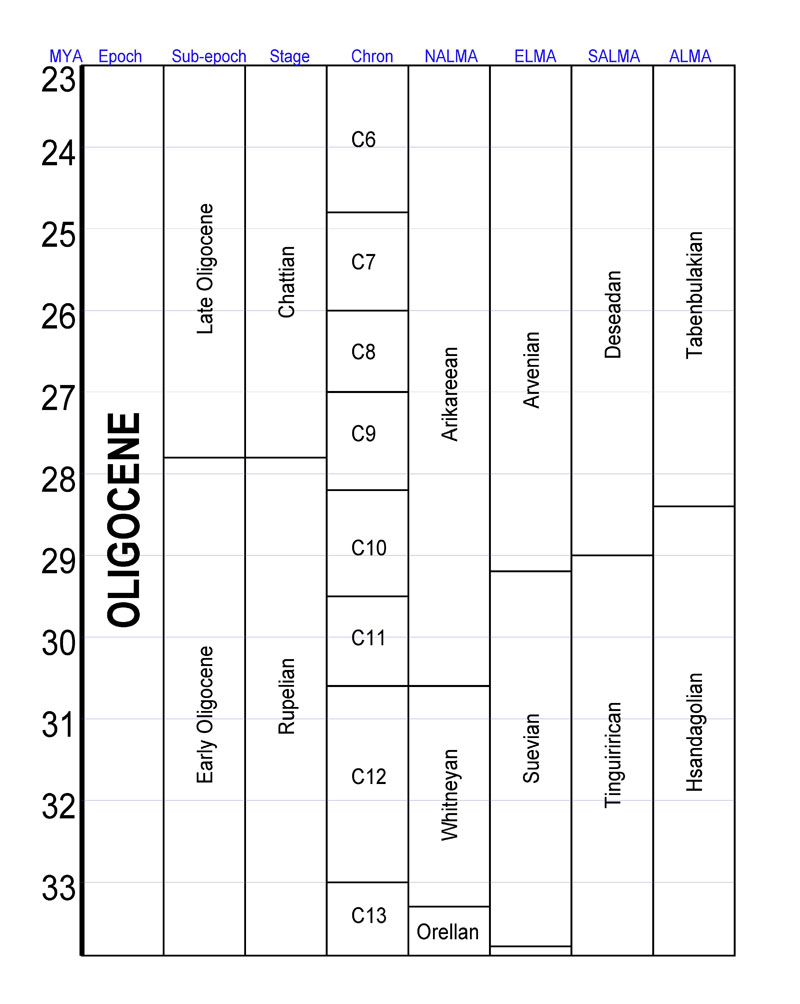
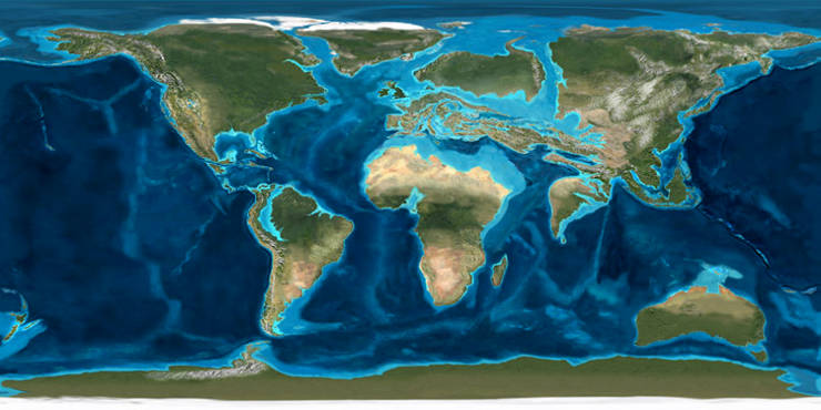
The Oligocene ( ) is a geologic epoch (geology), epoch of the Paleogene Geologic time scale, Period that extends from about 33.9 million to 23 million years before the present ( to ). As with other older geologic periods, the rock beds that define the epoch are well identified but the exact dates of the start and end of the epoch are slightly uncertain. The name Oligocene was coined in 1854 by the German paleontologist Heinrich Ernst Beyrich from his studies of marine beds in Belgium and Germany. The name comes from Ancient Greek (''olígos'') 'few' and (''kainós'') 'new', and refers to the sparsity of Neontology, extant forms of Mollusca, molluscs. The Oligocene is preceded by the Eocene Epoch and is followed by the Miocene Epoch. The Oligocene is the third and final epoch of the Paleogene Period. The Oligocene is often considered an important time of transition, a link between the archaic world of the tropical Eocene and the more modern ecosystems of the Miocene. Major chang ... [...More Info...] [...Related Items...] OR: [Wikipedia] [Google] [Baidu] |
Eocene
The Eocene ( ) is a geological epoch (geology), epoch that lasted from about 56 to 33.9 million years ago (Ma). It is the second epoch of the Paleogene Period (geology), Period in the modern Cenozoic Era (geology), Era. The name ''Eocene'' comes from the Ancient Greek (''Ēṓs'', 'Eos, Dawn') and (''kainós'', "new") and refers to the "dawn" of modern ('new') fauna that appeared during the epoch.See: *Letter from William Whewell to Charles Lyell dated 31 January 1831 in: * From p. 55: "The period next antecedent we shall call Eocene, from ήως, aurora, and χαινος, recens, because the extremely small proportion of living species contained in these strata, indicates what may be considered the first commencement, or ''dawn'', of the existing state of the animate creation." The Eocene spans the time from the end of the Paleocene Epoch to the beginning of the Oligocene Epoch. The start of the Eocene is marked by a brief period in which the concentration of the carbon isoto ... [...More Info...] [...Related Items...] OR: [Wikipedia] [Google] [Baidu] |
Jurassic
The Jurassic ( ) is a Geological period, geologic period and System (stratigraphy), stratigraphic system that spanned from the end of the Triassic Period million years ago (Mya) to the beginning of the Cretaceous Period, approximately 143.1 Mya. The Jurassic constitutes the second and middle period of the Mesozoic, Mesozoic Era as well as the eighth period of the Phanerozoic, Phanerozoic Eon and is named after the Jura Mountains, where limestone strata from the period were first identified. The start of the Jurassic was marked by the major Triassic–Jurassic extinction event, associated with the eruption of the Central Atlantic magmatic province, Central Atlantic Magmatic Province (CAMP). The beginning of the Toarcian Age started around 183 million years ago and is marked by the Toarcian Oceanic Anoxic Event, a global episode of Anoxic event, oceanic anoxia, ocean acidification, and elevated global temperatures associated with extinctions, likely caused by the eruption of the Kar ... [...More Info...] [...Related Items...] OR: [Wikipedia] [Google] [Baidu] |


