|
Needle Island
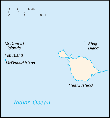
Needle Island () is a pinnacle rock lying 0.2 nautical miles (0.4 km) west of the north end of McDonald Island in the McDonald Islands. Surveyed and given this descriptive name by ANARE (Australian National Antarctic Research Expeditions The Australian National Antarctic Research Expeditions (ANARE ) is the historical name for the Australian Antarctic Program (AAp) administered for Australia by the Australian Antarctic Division (AAD). History Australia has had a long involv ...) in 1948. See also * List of antarctic and sub-antarctic islands Landforms of Heard Island and McDonald Islands Rock formations of Antarctica {{Subantarctic-geo-stub ... [...More Info...] [...Related Items...] OR: [Wikipedia] [Google] [Baidu] |
Heard Island And McDonald Islands
The Territory of Heard Island and McDonald Islands (HIMI) is an Australian external territory comprising a volcanic group of mostly barren Antarctic islands, about two-thirds of the way from Madagascar to Antarctica. The group's overall size is in area and it has of coastline. Discovered in the mid-19th century, the islands lie on the Kerguelen Plateau in the Indian Ocean and have been an Australian territory since 1947. They contain Australia's only two active volcanoes. The summit of one, Mawson Peak, is higher than any mountain in all other Australian states or territories, except Dome Argus, Mount McClintock and Mount Menzies in the Australian Antarctic Territory. The islands are among the most remote places on Earth: They are located about southwest of Perth, southwest of Cape Leeuwin, Australia, southeast of South Africa, southeast of Madagascar, north of Antarctica, and southeast of the Kerguelen Islands (part of French Southern and Antarctic Lands). The ... [...More Info...] [...Related Items...] OR: [Wikipedia] [Google] [Baidu] |
McDonald Islands
The McDonald Islands () are an uninhabited archipelago in the southern Indian Ocean in the vicinity of Heard Island (). Together with Heard Island, they make up the Australian external Territory of Heard Island and McDonald Islands. The McDonald Islands are the emergent peaks of submarine volcanoes and are Australian external territory. Prior to 1992, there had not been an eruption in the previous 75,000 years. Morphology The McDonald Islands comprise three islands: McDonald Island, Flat Island (which later merged with McDonald Island) and Meyer Rock. The islands are mostly composed of phonolitic low-silica pumice, dikes and lava domes, and sit atop a submarine plateau, the Kerguelen Plateau. They are located about 75 km from Heard Island. McDonald Island is the largest of the islands, at around in area. It has been the main focus of volcanic activity in recent times. Prior to 1996, McDonald Island had been a flat green island whose pumice beaches provided a great ne ... [...More Info...] [...Related Items...] OR: [Wikipedia] [Google] [Baidu] |
Australian National Antarctic Research Expeditions
The Australian National Antarctic Research Expeditions (ANARE ) is the historical name for the Australian Antarctic Program (AAp) administered for Australia by the Australian Antarctic Division (AAD). History Australia has had a long involvement in south polar regions since as early as Douglas Mawson's Australasian Antarctic Expedition in 1911. Further Australian exploration of the Antarctic continent was conducted during the British Australian and New Zealand Antarctic Research Expedition (BANZARE), which was conducted over the years 1929–1931. The Australian National Antarctic Research Expeditions were established in 1947 with expeditions to Macquarie Island and Heard Island. In 1948 the Australian Antarctic Division (AAD) was established to administer the expedition program. ANARE Name The name ANARE fell out of official use in the early 2000s. However current and former Australian Antarctic expeditioners continue to use the term informally as a means of identi ... [...More Info...] [...Related Items...] OR: [Wikipedia] [Google] [Baidu] |
Landforms Of Heard Island And McDonald Islands
A landform is a natural or anthropogenic land feature on the solid surface of the Earth or other planetary body. Landforms together make up a given terrain, and their arrangement in the landscape is known as topography. Landforms include hills, mountains, canyons, and valleys, as well as shoreline features such as bays, peninsulas, and seas, including submerged features such as mid-ocean ridges, volcanoes, and the great ocean basins. Physical characteristics Landforms are categorized by characteristic physical attributes such as elevation, slope, orientation, stratification, rock exposure and soil type. Gross physical features or landforms include intuitive elements such as berms, mounds, hills, ridges, cliffs, valleys, rivers, peninsulas, volcanoes, and numerous other structural and size-scaled (e.g. ponds vs. lakes, hills vs. mountains) elements including various kinds of inland and oceanic waterbodies and sub-surface features. Mountains, hills, plateaux, and plains are the fou ... [...More Info...] [...Related Items...] OR: [Wikipedia] [Google] [Baidu] |


.jpg)
.jpg)