|
National Route 1 (Vietnam)
National Route 1 (), also known as National Route 1A, is the trans-Vietnam highway. The route begins at km 0 at Friendship Pass, Hữu Nghị Quan Border Gate near the China-Vietnam border, runs the length of the country connecting major cities including Hanoi, Da Nang and Ho Chi Minh City, and ends at km 2301.34 at Năm Căn township in Cà Mau province. Road layout National Route 1 runs across provinces and cities of Vietnam: *Lạng Sơn (km 16) *Bắc Giang (km 119) *Bắc Ninh (km 139) *City of Hanoi (the capital) (km 171) *Phủ Lý (km 229, province of Hà Nam province, Hà Nam) *Ninh Bình (km 263) *Thanh Hóa (km 324) *Vinh (km 462, Nghệ An province, Nghệ An) *Hà Tĩnh (km 510) *Đồng Hới (km 660, province of Quảng Bình province, Quảng Bình) *Đông Hà (km 756, province of Quảng Trị province, Quảng Trị) *City of Huế (km 825) *City of Da Nang (km 930) *Tam Kỳ (km 991, province of Quảng Nam province, Quảng Nam) *Quảng Ngãi (km 1054) *via ... [...More Info...] [...Related Items...] OR: [Wikipedia] [Google] [Baidu] |
Từ Sơn
Từ Sơn is a city of Bắc Ninh Province in the Red River Delta region of Vietnam. As of 2021, Từ Sơn had a population of 202,874, covering an area of 61.08 km². The centre ward is Đông Ngàn, formerly Từ Sơn township. In 974, Lý Thái Tổ was born in this town. The Lý Bát Đế Shrine is located here. References Municipalities of Bắc Ninh province Cities in Vietnam {{BacNinh-geo-stub ... [...More Info...] [...Related Items...] OR: [Wikipedia] [Google] [Baidu] |
Thanh Hóa
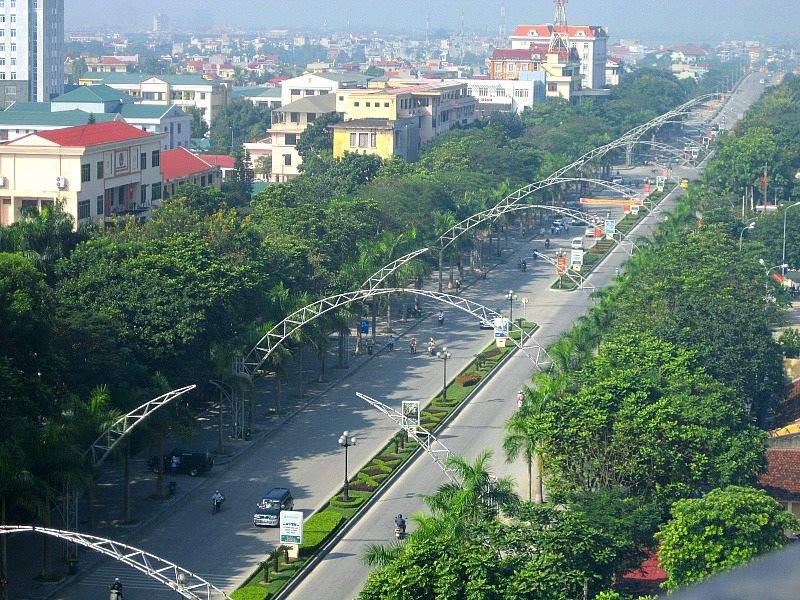
Thanh Hóa () is the capital of Thanh Hóa Province. The city is situated in the east of the province on the Ma River (Sông Mã), about 150 kilometers (93 miles) south of capital Hanoi and 1560 kilometers (969 miles) north of Ho Chi Minh City. Thanh Hoa became one of the most populous cities in North Central Coast after expanding in 2012, with a population of approximately 400,000. Thanh Hoa township was upgraded to Thanh Hoa City in 1994 and has been the historical center of politics, economy, culture, education and entertainment of Thanh Hóa Province. Overview ''Thanh Hoá'' is a new developing city, although its central position was established centuries before. Nowadays, provincial administrators are trying to build and gentrify the city so that its important role for the whole province and even North Central Coast is emphasised. History The Citadel of the Hồ Dynasty was the capital of the Trần dynasty from 1398 to 1400 and the Hồ dynasty from 1400 to 1407. ... [...More Info...] [...Related Items...] OR: [Wikipedia] [Google] [Baidu] |
Triệu Phong District
Triệu (; ) is a Chinese-language surname, it is the Vietnamese translation of the Chinese surname Zhao (趙). It is commonly found in Vietnam among its Chinese diaspora. Individuals with the surname, Triệu, likely migrated to Vietnam from the Guangdong and Fujian Provinces of China. It is the same as the Cantonese romanization "Chiu", the Taiwanese or Hong Kong romanization of "Chao" or the Korean romanization of "Cho" (조). The name is first in the Hundred Family Surnames – the traditional list of all Chinese surnames – because it was the emperor's surname of the Song dynasty (960–1279) when the list was compiled. Zhao was listed as one of the most common names in China along with Wang, Li, Zhang, Liu, Chen, Yang, Huang, Zhou, and Wu. However, families with the surname "Zhao" that migrated to Vietnam and changed their name to "Triệu" are rare, estimated as 0.16% of the population in Vietnam and 0.001% of the population in the United States. Trieu is the a ... [...More Info...] [...Related Items...] OR: [Wikipedia] [Google] [Baidu] |
Ho Chi Minh Highway
Ho Chi Minh Road or Ho Chi Minh Highway () is a highway in Vietnam. It runs from the north to the south of Vietnam, west of National Route 1. The highway was named after Hồ Chí Minh. History The route roughly coincides with the Ho Chi Minh trail during the Vietnam War. It is a two-lane highway and is planned to become an 8-lane highway and it will connect Cao Bằng province by the Sino-Vietnamese border to Cà Mau province with the total length of 2,436 km. As of 2007, this road runs from Hoa Lac in Hanoi to Ngoc Hoi in Kon Tum province with a total length of 1,234.5 km. Route In Village number 5, Xuân Trạch commune, Bố Trạch district, Quảng Bình province, the road divides (QL15-QL16 intersection) into two separate roads: Đường Hồ Chí Minh Đông (Ho Chi Minh Highway East) and Đường Hồ Chí Minh Tây (Ho Chi Minh Highway West). Đường Hồ Chí Minh Đông is a well-traveled road with many trucks, towns and restaurants along it. There ... [...More Info...] [...Related Items...] OR: [Wikipedia] [Google] [Baidu] |
Đông Hà
Đông Hà () is the capital of Quảng Trị Province, in the North Central Coast region, the Central of Vietnam. As of 2024, the city's population is approximately about 164,228 people. It is located north of Huế and south of Đồng Hới in Quảng Bình Province. History The city was initially part of Champa, until it was conquered by the Qin Empire who were in control of most of Vietnam at the time. In the 2nd century CE, the Cham people rebelled against Chinese rule. During the 14th and 15th century, ethnic Vietnamese gradually admixed with the Cham inhabitants. During the Vietnam War, Đông Hà was the northernmost town in South Vietnam and was the location of a strategically important United States Marine Corps Đông Hà Combat Base, to support Marine positions along the Vietnamese Demilitarized Zone (DMZ).Keith W. Nolan ''The Story of an Armored Cavalry Squadron in Vietnam: 1-1 Cav, 1967-1968'' ... Just north of Đông Hà on April 6 the corresponden ... [...More Info...] [...Related Items...] OR: [Wikipedia] [Google] [Baidu] |
Quảng Bình Province
Quảng Bình was formerly a southern coastal Provinces of Vietnam, province in the North Central Coast region, the Central Vietnam, Central of Việt Nam, Vietnam. It borders Hà Tĩnh province, Hà Tĩnh to the north, Quảng Trị province, Quảng Trị to the south, Khammouane province, Khammouane of Laos to the west and the Gulf of Tonkin (South China Sea) to the east. On June 12th, 2025, Quảng Bình was merged into Quảng Trị province, Quảng Trị. History Quảng Bình was formerly Tiên Bình prefecture under the reign of Lê Trung Hưng of the Lê dynasty (this province was renamed Quảng Bình in 1604). The province has an area of and population of 913,860 inhabitants (as of 2022). Historically, this region belonged to kingdom of Champa. Later it was claimed by both the An Nam and Champa and officially annexed into An Nam by Lý Thường Kiệt, a Lý dynasty general (under the reign of Lý Thánh Tông) in 1069. The site of present-day Quảng Bình ... [...More Info...] [...Related Items...] OR: [Wikipedia] [Google] [Baidu] |
Ba Đồn
Ba Đồn is a town (thị xã) in Quảng Bình Province, Vietnam. The town is equal to a huyện and is located on National Route 1 (Vietnam), National Route 1, about 40 km north of the provincial capital, Đồng Hới. The township is the commercial and service centre serving surrounding rural areas. Ba Đồn was incorporated into a 3rd municipality (town or ''thị xã'') including some neighboring communes of Quảng Trạch District on December 20, 2013. Ba Đồn has an area of 163.1828 km2 and its population in 2013 was 115,196. In 2012, Ba Đồn was recognised as a class IV municipality.Decision 367/QĐ-BXD dated 18 April 2012 by the Minister of Construction on recognising extended Ba Đồn Town meeting class IV municipality norm. Geography Ba ...[...More Info...] [...Related Items...] OR: [Wikipedia] [Google] [Baidu] |
Vinh
Vinh () is the capital of Nghệ An province and an economic and cultural center of North-Central Vietnam. A key point in the East–West economic corridor linking Myanmar, Thailand, Laos and Vietnam, the city is situated in the Southeast of the province, alongside the Lam River and is located on the main North–South transportation route of Vietnam, making it accessible by highway, railroad, boat and air. The Vinh International Airport is served daily by four carriers: Vietnam Airlines, VietJet Air, Bamboo Airways and Jetstar Pacific. On September 5, 2008, it was upgraded from Grade-II city to Grade-I city, the fifth city to hold the status, after Haiphong, Đà Nẵng and Huế. Vinh is the most populous city in the North Central Coastal region, with 790,000 residents as of 2024. The city is bordered by Nghi Lộc district to the North and East, Hưng Nguyên district to the West, and Nghi Xuân district of Hà Tĩnh Province to the South across the Lam River. Vin ... [...More Info...] [...Related Items...] OR: [Wikipedia] [Google] [Baidu] |
Diễn Châu
Diễn Châu is a township () and capital of Diễn Châu District, Nghệ An Province, Vietnam Vietnam, officially the Socialist Republic of Vietnam (SRV), is a country at the eastern edge of mainland Southeast Asia, with an area of about and a population of over 100 million, making it the world's List of countries and depende .... References Populated places in Nghệ An province District capitals in Vietnam Townships in Vietnam {{NgheAn-geo-stub ...[...More Info...] [...Related Items...] OR: [Wikipedia] [Google] [Baidu] |


