|
Nanoose Bay
Nanoose Bay is a community on the east coast of southern Vancouver Island, British Columbia, Canada. The location off BC Highway 19 is by road about north of Nanaimo, and south of Parksville. Name origin In 1862, John Enos (Joao Ignacio) became the first European settler on the Nanoose Bay Peninsula. The bay was spelled Noonooa on an 1864 map. The current anglicized spelling was adopted by the early 1870s. The Nanoose First Nation called the peninsula Berry Point. In the early 1800s, a rival tribe massacred many members, who were berry picking. A child survivor was later known as "Nanoose Bob". Nanoose Bay settlement The Nanoose Bay community was formerly called Arlington after the Arlington Hotel, the post office name from 1906, until adopting Nanoose Bay in 1916. In 1957, Yvonne and John Ruggles opened a store on the hill in the Qualicum National Wildlife Area. The modern retail and commercial centre on Collins Cres is called the Red Gap Centre. A firehall, library, and ... [...More Info...] [...Related Items...] OR: [Wikipedia] [Google] [Baidu] |
British Columbia
British Columbia is the westernmost Provinces and territories of Canada, province of Canada. Situated in the Pacific Northwest between the Pacific Ocean and the Rocky Mountains, the province has a diverse geography, with rugged landscapes that include rocky coastlines, sandy beaches, forests, lakes, mountains, inland deserts and grassy plains. British Columbia borders the province of Alberta to the east; the territories of Yukon and Northwest Territories to the north; the U.S. states of Washington (state), Washington, Idaho and Montana to the south, and Alaska to the northwest. With an estimated population of over 5.7million as of 2025, it is Canada's Population of Canada by province and territory, third-most populous province. The capital of British Columbia is Victoria, British Columbia, Victoria, while the province's largest city is Vancouver. Vancouver and its suburbs together make up List of census metropolitan areas and agglomerations in Canada, the third-largest metropolit ... [...More Info...] [...Related Items...] OR: [Wikipedia] [Google] [Baidu] |
Victoria–Courtenay Train
The Victoria–Courtenay train (named the ''Malahat'' until 2009) was a passenger train service operated by Via Rail between Victoria, Nanaimo, and Courtenay on Vancouver Island in British Columbia. The service operated over the Island Rail Corridor. In March 2011, was suspended indefinitely due to poor track conditions along the line. History Via Rail Canada The train was formerly operated with Budd Rail Diesel Car The Budd Rail Diesel Car (RDC), also known as the Budd car or Buddliner, is a self-propelled diesel multiple unit (DMU) railcar. Between 1949 and 1962, 398 RDCs were built by the Budd Company of Philadelphia, Pennsylvania, United States. The cars ...s. Via Rail took over passenger services from CP Rail, renaming the service the Malahat in 1979. The tracks were given minor maintenance due to low ridership, leading to service suspension. Service suspension Due to poor track conditions on March 19, 2011, the service was suspended indefinitely for track replacement ... [...More Info...] [...Related Items...] OR: [Wikipedia] [Google] [Baidu] |
Unincorporated Settlements In British Columbia
Unincorporated may refer to: * Unincorporated area, land not governed by a local municipality * Unincorporated entity, a type of organization * Unincorporated territories of the United States, territories under U.S. jurisdiction, to which Congress has determined that only select parts of the U.S. Constitution apply * Unincorporated association Unincorporated association refers to a group of people in common law jurisdictions—such as the United Kingdom, Canada, and New Zealand—who organize around a shared purpose without forming a corporation or similar legal entity. Unlike in some ..., also known as voluntary association, groups organized to accomplish a purpose * ''Unincorporated'' (album), a 2001 album by Earl Harvin Trio {{disambig ... [...More Info...] [...Related Items...] OR: [Wikipedia] [Google] [Baidu] |
Torpedo
A modern torpedo is an underwater ranged weapon launched above or below the water surface, self-propelled towards a target, with an explosive warhead designed to detonate either on contact with or in proximity to the target. Historically, such a device was called an automotive, automobile, locomotive, or fish torpedo; colloquially, a ''fish''. The term ''torpedo'' originally applied to a variety of devices, most of which would today be called mines. From about 1900, ''torpedo'' has been used strictly to designate a self-propelled underwater explosive device. While the 19th-century battleship had evolved primarily with a view to engagements between armored warships with large-caliber guns, the invention and refinement of torpedoes from the 1860s onwards allowed small torpedo boats and other lighter surface vessels, submarines/submersibles, even improvised fishing boats or frogmen, and later light aircraft, to destroy large ships without the need of large guns, though somet ... [...More Info...] [...Related Items...] OR: [Wikipedia] [Google] [Baidu] |
CFMETR, Nanoose Bay
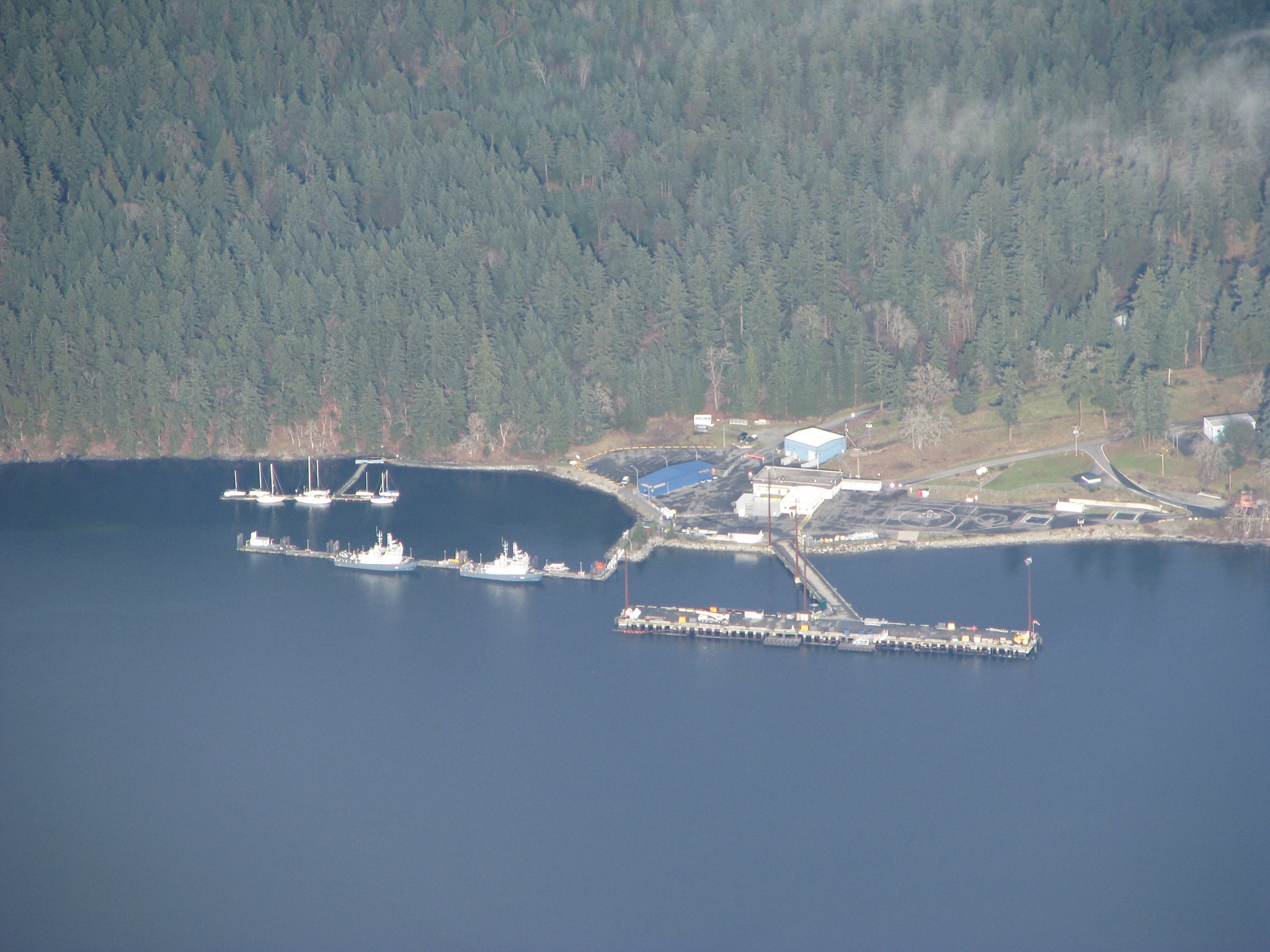
The Canadian Forces Maritime Experimental and Test Ranges (CFMETR) is a maritime test facility on the east side of Vancouver Island, at Nanoose Bay. The ranges operated by CFMETR are located over an area of the Strait of Georgia—known as Area WG—that is several hundred metres deep, several dozen kilometres long and several kilometres wide over a seabed composed of soft mud and free of underwater obstacles. The facility employs a three-dimensional sonar tracking system for monitoring the performance and position of objects in these waters for real-time tracking. During periods of activity, the range area is closed off from all civilian maritime traffic as a safety measure. Equipment tested at the facility consists of a variety of devices, including sonobuoys, sonar systems (ship and aircraft), torpedoes and the repair and overhaul of the dipping sonar used on Canada's Sikorsky CH-148 Cyclone helicopter fleet. No explosives are used. This facility is unique in the Ca ... [...More Info...] [...Related Items...] OR: [Wikipedia] [Google] [Baidu] |
Red Gap, British Columbia
Red Gap is southeast of Nanoose Bay on the east coast of southern Vancouver Island, British Columbia. The ghost town on BC Highway 19 is by road about north of Nanaimo, and south of Parksville. Name origin Formerly, the location was known as part of "the flats" of Nanoose Bay. Logs were delivered by the adjacent E&N Railway for offloading, assembling as log rafts, and towing by tug to various sawmills. When Joe and Max McKercher established a sawmill in 1912, the mill name defined the location. When a precise name was needed for the opening of the post office in 1917, Harry Leon Wilson's 1915 novel provided the inspiration for the community name, the 1918 Ruggles of Red Gap movie, and the two remakes. Sawmill The 1913 takeover by Newcastle Lumber Company and Merchant Trust joint venture suggests financial problems, but the employees were able to field their first mill soccer team that year. After bankruptcy, the mill was idle throughout 1916, before acquisition by Frank Pen ... [...More Info...] [...Related Items...] OR: [Wikipedia] [Google] [Baidu] |
Berth (moorings)
A berth is a designated location in a port or harbour used for mooring vessels when they are not at sea. Berths provide a vertical front which allows safe and secure mooring that can then facilitate the unloading or loading of cargo or people from vessels. Locations in a port Berth is the term used in ports and harbors for a designated location where a vessel may be moored, usually for the purposes of loading and unloading. Berths are designated by the management of a facility (e.g., port authority, harbor master). Vessels are assigned to berths by these authorities. Most berths are alongside a quay or a jetty (large ports) or a floating dock (small harbors and marinas). Berths are either general or specific to the types of vessel that use them. The size of the berths varies from for a small boat in a marina to over for the largest tankers. The rule of thumb is that the length of a berth should be roughly 10% longer than the longest vessel to be moored at the berth. B ... [...More Info...] [...Related Items...] OR: [Wikipedia] [Google] [Baidu] |
Narrow Gauge Railway
A narrow-gauge railway (narrow-gauge railroad in the US) is a railway with a track gauge (distance between the rails) narrower than . Most narrow-gauge railways are between and . Since narrow-gauge railways are usually built with Minimum railway curve radius, tighter curves, smaller structure gauges, and lighter Rail profile, rails; they can be less costly to build, equip, and operate than standard- or broad-gauge railways (particularly in mountainous or difficult terrain). Lower-cost narrow-gauge railways are often used in mountainous terrain, where engineering savings can be substantial. Lower-cost narrow-gauge railways are often built to serve industries as well as sparsely populated communities where the traffic potential would not justify the cost of a standard- or broad-gauge line. Narrow-gauge railways have specialised use in mines and other environments where a small structure gauge necessitates a small loading gauge. In some countries, narrow gauge is the standard: Ja ... [...More Info...] [...Related Items...] OR: [Wikipedia] [Google] [Baidu] |
Wellington, British Columbia
Wellington, formerly a separate district and town, is a neighbourhood of north Nanaimo, on the east coast of southern Vancouver Island, British Columbia. First Nations & European settlement Wellington was part of the traditional territories of the Sneneymuxw and Nanoose First Nations, who coexisted with European arrivals. The district was likely named in the 1850s following the 1852 death of Arthur Wellesley, 1st Duke of Wellington. Prior to 1869, few settlers inhabited the areas around Brannen, Long, and Diver lakes. Dunsmuir discovery Opened around 1860 by the Hudson's Bay Company (HBC), Douglas Mine, in today's downtown Nanaimo, was the first coalmine in the region. While fishing about northwest at Diver Lake in 1869, former HBC employee Robert Dunsmuir observed evidence of coal deposits, in what he would call the Wellington seam. The location was just beyond the northern boundary of the Vancouver Coal Mining and Land Company's property, acquired from the HBC in 1862. Neigh ... [...More Info...] [...Related Items...] OR: [Wikipedia] [Google] [Baidu] |
Qualicum National Wildlife Area
The Qualicum National Wildlife Area (NWA) was officially established in 1977, under the Canada Wildlife Act (1973). The primary objective of the Qualicum NWA was to conserve crucial habitats for migratory birds and various other species. The national wildlife area consists of three small units - Rosewall Creek, Marshall-Stevenson Wildlife Sanctuary, Marshall-Stevenson, and Nanoose Bay - spread out along the northeastern coast Vancouver Island between the communities of Fanny Bay and Nanoose Bay. Since it is a National Wildlife Area, National Wildlife Area (NWA), Qualicum NWA is governed by the Canada Wildlife Act and managed by the Canadian government department Environment and Climate Change Canada. While most National Wildlife Areas are closed to the public to reduce the human impacts on the land, vegetation, animals, and insects, the Qualicum NWA is open for certain recreational activities, such as wildlife viewing and hiking as well as hunting in certain areas. Topography ... [...More Info...] [...Related Items...] OR: [Wikipedia] [Google] [Baidu] |
Canada
Canada is a country in North America. Its Provinces and territories of Canada, ten provinces and three territories extend from the Atlantic Ocean to the Pacific Ocean and northward into the Arctic Ocean, making it the world's List of countries and dependencies by area, second-largest country by total area, with the List of countries by length of coastline, world's longest coastline. Its Canada–United States border, border with the United States is the world's longest international land border. The country is characterized by a wide range of both Temperature in Canada, meteorologic and Geography of Canada, geological regions. With Population of Canada, a population of over 41million people, it has widely varying population densities, with the majority residing in List of the largest population centres in Canada, urban areas and large areas of the country being sparsely populated. Canada's capital is Ottawa and List of census metropolitan areas and agglomerations in Canada, ... [...More Info...] [...Related Items...] OR: [Wikipedia] [Google] [Baidu] |


