|
Namahage
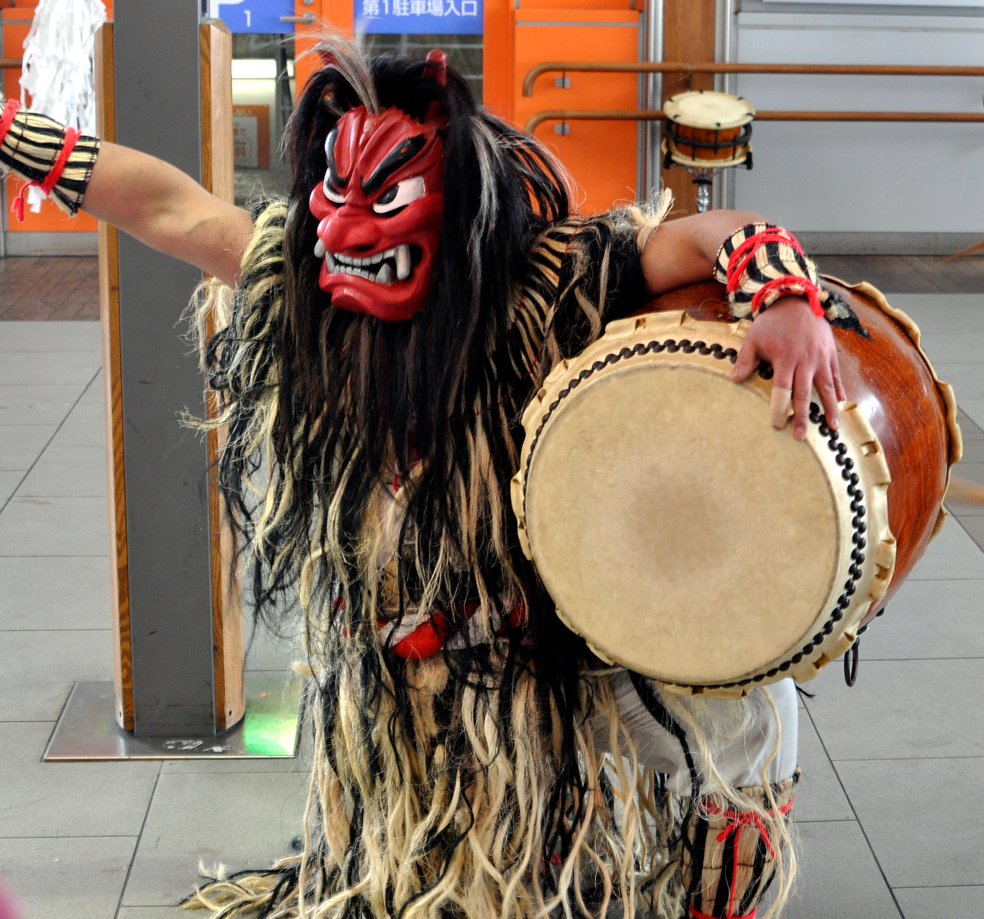
The are demonlike beings portrayed by men wearing hefty ''oni'' (ogre) masks and traditional straw capes (''mino (straw cape), mino'') during a New Year's ritual, in local northern Japanese folklore of the Oga Peninsula area of Akita Prefecture. General description Namahage are portrayed by men who don ''oni'' masks and dress in long straw coats or ''mino (straw cape), mino'', which are locally called ''kede'' or ''kende''. They are equipped with Deba knife, deba knives (usually fakes made of wood or papier-mâché) and a . Marching in small groups of two or three, the namahage go door-to-door between people's homes, admonishing children who may be guilty of laziness or bad behavior by yelling phrases like or in the pronunciation and accent of the local dialect. Traditionally, the namahage have worn painted wooden masks, sometimes made of wood bark, and primarily painted red. In recent years, however, masks are manufactured using cardboard material, flattened metal canisters ... [...More Info...] [...Related Items...] OR: [Wikipedia] [Google] [Baidu] |
Akita Prefecture
is a Prefectures of Japan, prefecture of Japan located in the Tōhoku region of Honshu.Nussbaum, Louis-Frédéric. (2005). "Provinces and prefectures" in ; "Tōhoku" in . Its population is estimated 915,691 as of 1 August 2023 and its geographic area is 11,637 Square kilometre, km2 (4,493 sq mi). Akita Prefecture is bordered by Aomori Prefecture to the north, Iwate Prefecture to the east, Miyagi Prefecture to the southeast, and Yamagata Prefecture to the south. Akita, Akita, Akita is the capital and largest city of Akita Prefecture. Other major cities include Yokote, Akita, Yokote, Daisen, Akita, Daisen, and Yurihonjō. Akita Prefecture is located on the coast of the Sea of Japan and extends east to the Ōu Mountains, the longest mountain range in Japan, at the border with Iwate Prefecture. Akita Prefecture formed the northern half of the historic Dewa Province with Yamagata Prefecture. History The region of Akita was created from the ancient provinces of Dewa Province, De ... [...More Info...] [...Related Items...] OR: [Wikipedia] [Google] [Baidu] |
Oga, Akita
is a city located in Akita Prefecture, Japan. , the city has an estimated population of 24,687 in 12,496 households, and a population density of 100 persons per km2. The total area of the city is . Geography Oga is located on the Oga Peninsula in northwestern Akita Prefecture, bordered by the Sea of Japan to the north, west and south. The Oga Peninsula has two mountains, Mount Kanpu and Mount Honzan, and several rivers, including the Takigawa. Toga Bay is located in the western part of the city, where Toga Port is located, and he northwestern end is called Cape Nyūdō. The population is concentrated in the southern part of the city, where the railway runs and the city hall is located. Much of the city is within the boundaries of the Oga Quasi-National Park. Neighboring municipalities Akita Prefecture * Katagami * Mitane * Ōgata Climate Different from the rest of the prefecture, the climate is an isolated humid subtropical (Köppen: ''Cfa'') by direct influence (due to ... [...More Info...] [...Related Items...] OR: [Wikipedia] [Google] [Baidu] |
Oga Peninsula
The Oga Peninsula (男鹿半島 ''Oga-hantō'') is a rugged peninsula which projects west into the Sea of Japan from the coast of Akita in northern Honshū, the main island of Japan. Politically it coincides with the city A city is a human settlement of a substantial size. The term "city" has different meanings around the world and in some places the settlement can be very small. Even where the term is limited to larger settlements, there is no universally agree ... of Oga. At the base of the peninsula is Hachirōgata, formerly the second largest lake in Japan. Oga Peninsula is famous for the traditional festival of Namahage. Gallery File:Location OgaPeninsulaJp.jpg, Location File:Oga Peninsula Relief Map, SRTM-1.jpg, Relief Map File:Oga peninsula z.JPG, Kamo harbor File:Godzilla-iwa in Oga,Akita.jpg, Godzilla Rock File:Oga Aquarium 20200118b.jpg, Oga Aquarium Gao File:Straw namahage.1.jpg, Namahage Museum See also * Oga Aquarium Gao * Wakimoto Castle Touris ... [...More Info...] [...Related Items...] OR: [Wikipedia] [Google] [Baidu] |
Japanese Folklore
Japanese folklore encompasses the informally learned folk traditions of Japan and the Japanese people as expressed in its oral traditions, Tradition, customs, and material culture. In Japanese, the term is used to describe folklore. The Folklore studies, academic study of folklore is known as . Folklorists also employ the term or to refer to the objects and arts they study. Folk religion Men dressed as namahage, wearing ogre-like masks and traditional straw capes (''mino (straw cape), mino'') make rounds of homes, in an annual ritual of the Oga Peninsula area of the Northeast region. These ogre-men masquerade as kami looking to instill fear in the children who are lazily idling around the fire. This is a particularly colorful example of folk practice still kept alive. A parallel custom is the secretive ritual of the Yaeyama Islands, Okinawa Prefecture, Okinawa which does not allow itself to be photographed. Many, though increasingly fewer households maintain a kamidana or ... [...More Info...] [...Related Items...] OR: [Wikipedia] [Google] [Baidu] |
Oni (folklore)
An ( ) is a kind of ''yōkai'', demon, orc, ogre, or troll in Japanese folklore. They are believed to live in caves or deep in the mountains or in hell. Oni are known for their superhuman strength and have been associated with powers like thunder and lightning, along with their evil nature manifesting in their propensity for murder and cannibalism. They are typically portrayed as hulking figures with one or more horns growing out of their heads, massive teeth, and occasionally a third eye in the center of the forehead."Oni." ''Handbook of Japanese Mythology'', by Michael Ashkenazi, ABC-CLIO, 2003, pp. 230–233. They are typically depicted with red, blue, black, or yellow colored skin, wearing loincloths of tiger pelt, and carrying iron kanabō clubs. They also have three to six digits on each hand and foot tipped with claw-like nails. Oni are able to change their looks to fool their victims into trusting them. Oni can be male or female, but have been predominantly male through ... [...More Info...] [...Related Items...] OR: [Wikipedia] [Google] [Baidu] |
Koshōgatsu
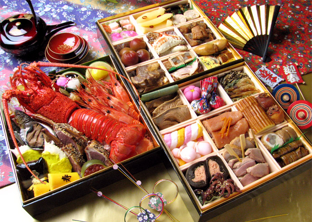
The is an annual festival that takes place in Japan. Since 1873, the official Japanese New Year has been celebrated according to the Gregorian calendar, on January 1 of each year, . Prior to 1872, traditional events of the Japanese New Year were celebrated on the first day of the year on the modern Tenpō calendar, the last official lunisolar calendar. History Prior to the Meiji period, the date of the Japanese New Year had been based on Japanese versions of lunisolar calendar (the last of which was the Tenpō calendar) and, prior to Jōkyō calendar, the Chinese version. However, in 1873, five years after the Meiji Restoration, Japan adopted the Gregorian calendar and the first day of January became the official and cultural New Year's Day in Japan. Traditional food The Japanese eat a selection of dishes during the New Year celebration called , typically shortened to ''osechi.'' Many of these dishes are sweet, sour, or dried, so they can be kept without refrigeration: the ... [...More Info...] [...Related Items...] OR: [Wikipedia] [Google] [Baidu] |
Yamagata Prefecture
is a Prefectures of Japan, prefecture of Japan located in the Tōhoku region of Honshu. It has a population of 1,005,926 (1 February 2025) and an area of 9,325 Square kilometre, km2 (3,600 Square mile, sq mi). Its neighbours are Akita Prefecture to the north, Miyagi Prefecture to the east, Fukushima Prefecture to the south, and Niigata Prefecture to the southwest. The capital and largest city is Yamagata, Yamagata, Yamagata, with other major cities being Tsuruoka, Yamagata, Tsuruoka, Sakata, Yamagata, Sakata and Yonezawa, Yamagata, Yonezawa. The prefecture is located on Japan's western Sea of Japan coast and its borders with neighboring prefectures are formed by various mountain ranges, with 17% of its total land area being designated as List of national parks of Japan, Natural Parks. Yamagata Prefecture formed the southern half of the historic Dewa Province with Akita Prefecture and is home to the Three Mountains of Dewa, which includes the Haguro Five-story Pagoda, a recognis ... [...More Info...] [...Related Items...] OR: [Wikipedia] [Google] [Baidu] |
Shikoku
is the smallest of the List of islands of Japan#Main islands, four main islands of Japan. It is long and between at its widest. It has a population of 3.8 million, the least populated of Japan's four main islands. It is south of Honshu and northeast of Kyushu. Shikoku's ancient names include , , and , and its current name refers to the four former provinces of Japan, provinces that make up the island: Awa Province (Tokushima), Awa, Tosa Province, Tosa, Sanuki Province, Sanuki, and Iyo Province, Iyo. Geography Shikoku Island, comprising Shikoku and its surrounding islands, covers about and consists of four Prefectures of Japan, prefectures: Ehime Prefecture, Ehime, Kagawa Prefecture, Kagawa, Kōchi Prefecture, Kōchi, and Tokushima Prefecture, Tokushima. Across the Seto Inland Sea lie Wakayama Prefecture, Wakayama, Osaka Prefecture, Osaka, Hyōgo Prefecture, Hyōgo, Okayama Prefecture, Okayama, Hiroshima Prefecture, Hiroshima, and Yamaguchi Prefectures on Honshu. To th ... [...More Info...] [...Related Items...] OR: [Wikipedia] [Google] [Baidu] |
Ehime Prefecture
is a Prefectures of Japan, prefecture of Japan located on the island of Shikoku. Ehime Prefecture has a population of 1,334,841 and a geographic area of 5,676 km2 (2,191 sq mi). Ehime Prefecture borders Kagawa Prefecture to the northeast, Tokushima Prefecture to the east, and Kōchi Prefecture to the southeast. Matsuyama is the capital and largest city of Ehime Prefecture and the largest city on Shikoku, with other major cities including Imabari, Ehime, Imabari, Niihama, and Saijō, Ehime, Saijō. Notable past Ehime residents include three Nobel Prize winners: Kenzaburo Oe (1994 Nobel Prize in Literature), Shuji Nakamura (2014 Nobel Prize in Physics), and Syukuro Manabe (2021 Nobel Prize in Physics). History Until the Meiji Restoration, Ehime Prefecture was known as Iyo Province. Since before the Heian period, the area was dominated by fishermen and sailors who played an important role in defending Japan against pirates and Mongols, Mongolian invasions. After the Battle of ... [...More Info...] [...Related Items...] OR: [Wikipedia] [Google] [Baidu] |
Okinawa Prefecture
is the southernmost and westernmost prefecture of Japan. It consists of three main island groups—the Okinawa Islands, the Sakishima Islands, and the Daitō Islands—spread across a maritime zone approximately 1,000 kilometers east to west and 400 kilometers north to south. Despite a modest land area of 2,281 km² (880 sq mi), Okinawa’s territorial extent over surrounding seas makes its total area nearly half the combined size of Honshu, Shikoku, and Kyushu. Of its 160 Island, islands, 49 are inhabited. The largest and most populous island is Okinawa Island, which hosts the capital city, Naha, as well as major urban centers such as Okinawa (city), Okinawa, Uruma, and Urasoe, Okinawa, Urasoe. The prefecture has a subtropical climate, characterized by warm temperatures and high rainfall throughout the year. People from the Ryukyu Islands, Nansei Islands, including Okinawa Island, Okinawa, the Sakishima Islands, and parts of Kagoshima Prefecture, are often collectively referred ... [...More Info...] [...Related Items...] OR: [Wikipedia] [Google] [Baidu] |


