|
N651 Highway (Philippines)
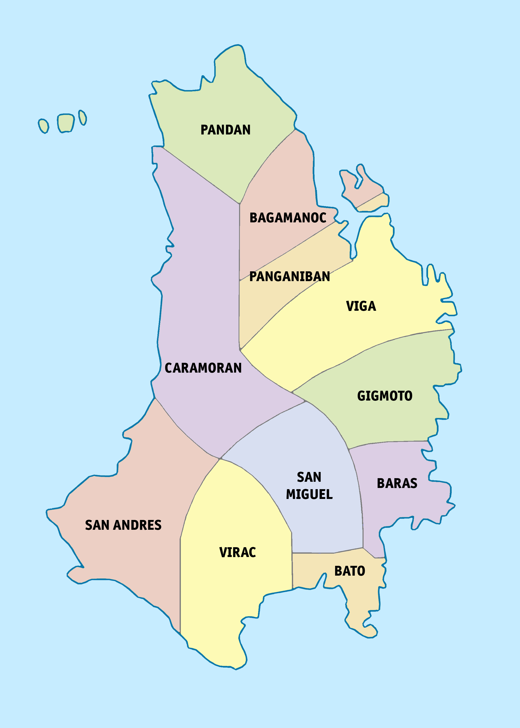
National Route 651 (N651) forms a part of the Philippine highway network. It is one of the national secondary roads with two non-wiktionary:contiguous, contiguous sections, one which runs through the city of Carmona, Cavite in the Calabarzon region, while the other road runs within the island of Catanduanes in the Bicol Region. Route description Cavite N651 runs through the section of Governor's Drive in the city of Carmona, Cavite, where the road is also known as Carmona Diversion Road as it bypasses the city proper. Upon reaching the Carmona Rotonda, the rest of the road going to the province of Laguna (province), Laguna is merged by N65 highway (Philippines), N65. Catanduanes In the Catanduanes province, N651 runs through the municipalities of Panganiban, Catanduanes, Panganiban and Caramoran, Catanduanes, Caramoran, where the entire signed road is known as Panganiban–Sabloyon Road. It connects with N650 (Catanduanes Circumferential Road) on both ends. References {{M ... [...More Info...] [...Related Items...] OR: [Wikipedia] [Google] [Baidu] |
Department Of Public Works And Highways
The Department of Public Works and Highways (DPWH; ) is the executive department of the Philippine government responsible for serving as the country's engineering and construction arm. It is tasked with implementing the government's policy to maintain and develop its engineering capabilities to ensure the safety, efficiency, and quality of public infrastructure and construction projects. The DPWH oversees the planning, design, construction, and maintenance of infrastructure across the country, particularly national highways, flood control systems, water resources development, and other public works. Its functions are to be carried out in a decentralized manner, as much as possible. History History of the DPWH stretches back as far as the history of Philippine government itself. During Spanish times, the Spanish constructed the first roads in the Philippines. These public works projects were not only used in the connection of towns and fortresses, but also in improving commu ... [...More Info...] [...Related Items...] OR: [Wikipedia] [Google] [Baidu] |
Governor's Drive
The Juanito R. Remulla Sr. Road, formerly and still commonly referred to as Governor's Drive, is a two-to-nine lane, network of primary, secondary and tertiary highways and bridges traversing through the central cities and municipalities of the province of Cavite, Philippines. It is the widest among the three major highways located in the province, the others being the Aguinaldo and Antero Soriano Highways. The road forms part of National Route 65 (N65), National Route 651 (N651), National Route 403 (N403), and National Route 405 (N405) of the Philippine highway network. A part of the road between the N403 and N405 section is a tertiary road and is unnumbered. Route description The eastern terminus of the highway is at the Carmona Bridge at the Carmona–Biñan boundary. It traverses Carmona, General Mariano Alvarez, Silang, Dasmariñas, General Trias, Trece Martires, Tanza, Naic, Maragondon, and Ternate. The highway is mostly concrete paved, while some other parts ar ... [...More Info...] [...Related Items...] OR: [Wikipedia] [Google] [Baidu] |
Carmona, Cavite
Carmona (), officially the City of Carmona (), is a Cities of the Philippines, component city in the Philippine Province, province of Cavite, Philippines. According to the 2020 census, it has a population of 106,256 people. Carmona is also the newest city in the Philippines; it became a city on July 8, 2023, and it was the 149th city founded in the Philippine archipelago. Etymology By virtue of a decree issued on February 20, 1857, by Queen Isabella II of Spain through Governor General Fernándo Norzagaray y Escudero, Latag became a separate municipality with the name it bears today: Carmona, Spain, Carmona, named after the Carmona, Spain, city of the same name in the province of Province of Seville, Seville, Spain. History Early history Carmona was formerly a settlement called Latag, which was annexed to the town of Silang, Cavite, Silang upon the latter's creation in 1595. The origins of its name are unknown. In 1856, the settlement's inhabitants demanded the conversion of ... [...More Info...] [...Related Items...] OR: [Wikipedia] [Google] [Baidu] |
Panganiban, Catanduanes
Panganiban, officially the Municipality of Panganiban, is a municipality in the province of Catanduanes, Philippines. According to the 2020 census, it has a population of 9,713 people. It is formerly known as Payo. Etymology Although the original name was Payo, this town has changed name from Panganiban to Payo and back again. During the last term of the late assemblyman Francisco Perfecto, Panganiban became Payo again on April 20, 1957, under Republic Act No. 1654. Congressman Jose M. Alberto (through Republic Act 2122 enacted without executive approval April 15, 1959) changed the name to Panganiban again by which it is officially known at present. According to legend, the town's early settlers elected a tribal chief whom they called “Payo” which could have been their vernacular term for headman. History On January 1, 1921, Governor General Francis B. Harrison signed into law Executive Order No. 55 officially segregating the municipality from Viga; thenceforth was call ... [...More Info...] [...Related Items...] OR: [Wikipedia] [Google] [Baidu] |
Caramoran, Catanduanes
Caramoran, officially the Municipality of Caramoran, is a municipality in the province of Catanduanes, Philippines. According to the 2020 census, it has a population of 32,114 people. The main sources of livelihood of the town are growing rice, coconuts, and lasa and fishing. The white beaches and clean sea water of Toytoy and Sabang, the water falls of Ab-haw, Awinis and Garagag are some of the attractions, and together with the Hilacan River, are the main source of water for irrigation. History The early Spanish missionaries who came to the Philippines landed in Napacahan, a sitio in Tubli and established a parish, which lasted for many years. In the parish church, St. John the Baptist had been venerated until this day as the Patron Saint (feast day June 24). Early Caramoran history disclosed the fact that the town originated in Napacahan, but due to relentless and repeated Muslim piracy in the 17th to the 18th century, the town was transferred to its present site Caramoran ... [...More Info...] [...Related Items...] OR: [Wikipedia] [Google] [Baidu] |
Philippine Highway Network
The Philippine highway network is a network of highway, national roads owned and maintained by the Department of Public Works and Highways (DPWH) and organized into three classifications according to their function or purpose: national primary, secondary, and tertiary roads. The national roads connecting major cities are numbered from N1 to N83. They are mostly single carriageway, single and dual carriageways linking two or more cities. As of October 16, 2023, it has a total length of of concrete roads, of asphalt roads, of gravel roads, and of earth roads, with a grand total of . According to a 2011 report from the Asian Development Bank, the extent of the road network in the Philippines is comparable with or better than many neighboring developing countries in Southeast Asia. However, in terms of the quality of the road system, i.e., the percentage of paved roads and the percentage of those in good or fair condition, the country lagged behind its neighbors . Classificat ... [...More Info...] [...Related Items...] OR: [Wikipedia] [Google] [Baidu] |
Contiguous
Contiguity or contiguous may refer to: *Contiguous data storage, in computer science *Contiguity (probability theory) *Contiguity (psychology) *Contiguous distribution of species, in biogeography *Geographic contiguity Geographic contiguity is the characteristic in geography of political or geographical land divisions, as a group, not being interrupted by other land or water. Such divisions are referred to as being ''contiguous.'' In the United States, for exam ... of territorial land * Contiguous zone in territorial waters See also * * {{disambig ... [...More Info...] [...Related Items...] OR: [Wikipedia] [Google] [Baidu] |
Calabarzon
Calabarzon (officially stylized in all caps; ; ), sometimes referred to as Southern Tagalog () and designated as Region IVA, is an administrative region in the Philippines. It is situated southeast of Metro Manila and is bordered by Manila Bay and the South China Sea to the west, Lamon Bay and the Bicol Region to the east, Tayabas Bay and the Sibuyan Sea to the south, and Central Luzon to the north. Comprising five provinces—Cavite, Laguna, Batangas, Rizal, and Quezon (hence the acronym)—and one highly urbanized city, Lucena, it is the most populous region in the Philippines, according to the 2020 census (PSA), with over 16.1 million inhabitants. It is also the country's second most densely populated region, after the National Capital Region. Calamba in Laguna serves as the regional center, while Antipolo in Rizal is the most populous city in the region. Before its creation as a separate region, Calabarzon, along with the Mimaropa region, the province of Aurora, ... [...More Info...] [...Related Items...] OR: [Wikipedia] [Google] [Baidu] |
Catanduanes
Catanduanes (; ), officially the Province of Catanduanes (), is an island province located in the Bicol Region of Luzon in the Philippines. It is the 12th-largest island in the Philippines, and lies to the east of Camarines Sur, across the Maqueda Channel. Its capital, and most populated town is Virac. Catanduanes had a population of 271,879 people as of the 2020 census. The province comprises Catanduanes (mainland or main island), Panay Island, Leyte Island, the Palumbanes group of islands (Porongpong, Tignob, and Calabagio), and a few other small, surrounding islets and rocks. The province is also home to various mollusk fossil sites, notably the second-oldest ammonite site in the Philippines. These sites contain certain species of ammonites that are found nowhere else in Southeast Asia. Because of the province's importance and rich geologic history, scholars have suggested that it could be named a UNESCO Geopark Reserve. In the early 20th century, Catanduanes was a s ... [...More Info...] [...Related Items...] OR: [Wikipedia] [Google] [Baidu] |
Bicol Region
The Bicol Region, designated as Region V, is an administrative region of the Philippines. It comprises six Provinces of the Philippines, provinces, four on the Bicol Peninsula (the luzon#Southeastern Luzon, southeastern end of Luzon): Albay, Camarines Norte, Camarines Sur, and Sorsogon, and two off the shore: Catanduanes and Masbate. The regional center is Legazpi, Albay, Legazpi, the most populous city in the region and has one Cities of the Philippines, independent component city, the pilgrim city of Naga, Camarines Sur, Naga. The region is bounded by Lamon Bay to the north, the Philippine Sea to the east, and the Sibuyan Sea and Ragay Gulf to the west. The northernmost provinces, Camarines Norte and Camarines Sur, are bordered to the west by the province of Quezon in the Calabarzon region. Geography The Bicol Region comprises the southern part of Luzon, the largest island in the Philippine archipelago. The total land area is 5.9% of the total land area of the country. Arou ... [...More Info...] [...Related Items...] OR: [Wikipedia] [Google] [Baidu] |
Laguna (province)
Laguna , officially the Province of Laguna (), is a Provinces of the Philippines, province in the Philippines located in the Calabarzon Regions of the Philippines, region in Luzon. Its capital is Santa Cruz, Laguna, Santa Cruz while its largest city is the Calamba, Laguna, City of Calamba (the regional center of Calabarzon) and the province is situated southeast of Metro Manila, south of the province of Rizal (province), Rizal, west of Quezon, north of Batangas and east of Cavite. Laguna hugs the southern shores of Laguna de Bay, the largest lake in the country. As of the 2020 census, the total population of Laguna is 3,382,193. Among all 82 provinces in the Philippines, Laguna accounted for the largest share (5%) of the national Gross Domestic Product (GDP) with a total of Php 990.69 billion in 2022. Laguna is notable as the birthplace of José Rizal, the country's ''de facto'' national hero. It has numerous natural and cultural attractions such as Cavinti Falls aka Pagsanjan ... [...More Info...] [...Related Items...] OR: [Wikipedia] [Google] [Baidu] |


