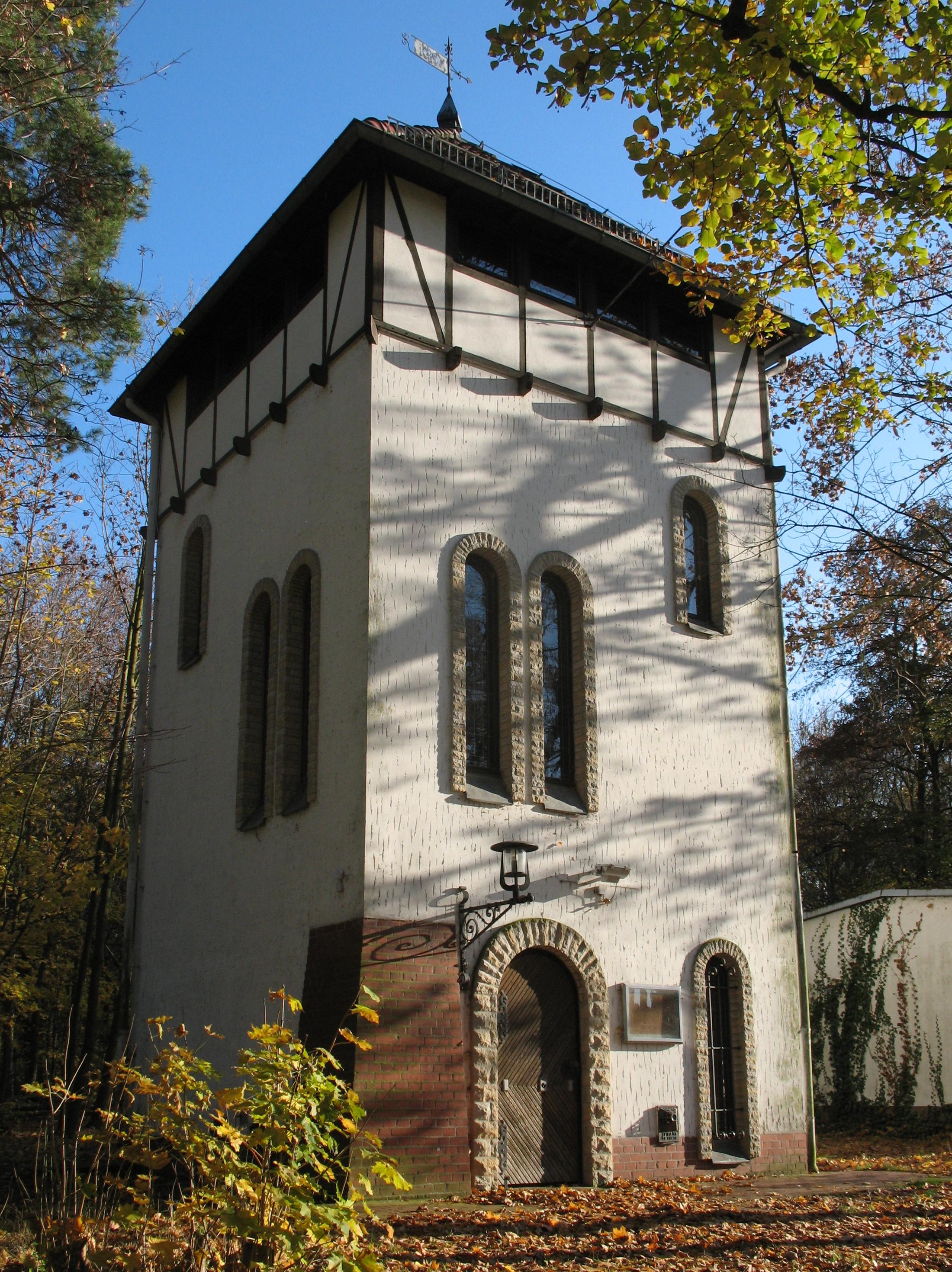
Müggelturm
   HOME


picture info

Müggelturm
The Müggelturm (“Müggel Tower”) is a popular day-trip destination in Köpenick, in southeastern Berlin, Germany. It is located to the south of the Müggelsee lake in the Müggelberg hills atop the ''Kleiner Müggelberg'' (“Small Müggelhill”). Berlin's highest natural elevation is the nearby ''Großer Müggelberg'' at 115 m. Access The Müggelturm area can be reached from the former ''Marienlust'' restaurant to the south at the River Dahme via a footpath ending in a stairway (374 steps), or from lake '' Müggelssee'' in the northeast up another stairway (111 steps). From the street Müggelheimer Damm there is a road leading to the tower (named ''Straße zum Müggelturm''), but cars must be left at a parking lot a few hundred metres before the plateau. The early towers In 1880, Carl Spindler, owner of the Köpenick laundry and dyeworks W. Spindler (and source of the name of the Berlin district ''Spindlersfeld''), had a 10 m high wooden lookout tower, known as the '' ...
[...More Info...]      
[...Related Items...]     OR:     [Wikipedia]   [Google]   [Baidu]  


picture info

Müggelsee
The Müggelsee (), also known as the Großer Müggelsee, is a natural lake in the eastern suburbs of Berlin, the capital city of Germany. It is the largest of the Berlin lakes by area, with an area of , a length of The lake is in the Berlin district of Treptow-Köpenick. The suburbs of Köpenick, Friedrichshagen, Rahnsdorf and a little section of Müggelheim border on the lake. The lake itself is deep at its deepest point. At its south end are hills called the 'Müggelberge', which are high; they were formed during the Pleistocene (as a kettle hole, remaining at Weichselian glaciation). On the so-called 'Kleiner Müggelberg', the much-visited and popular ' Müggelturm' (a tower) was built, the first one in 1889 (destroyed in a fire in 1958), and the current one in 1960/61. The tower offers extensive views over the lake and the forests against the Berlin skyline. The River Spree flows into the lake via the smaller Kleiner Müggelsee, which is only in area. The Friedrichs ...
[...More Info...]      
[...Related Items...]     OR:     [Wikipedia]   [Google]   [Baidu]  


picture info

Berlin Müggelturm 1
Berlin is the capital and largest city of Germany, both by area and by population. Its more than 3.85 million inhabitants make it the European Union's most populous city, as measured by population within city limits having gained this status after the United Kingdom's, and thus London's, departure from the European Union. Simultaneously, the city is one of the states of Germany, and is the third smallest state in the country in terms of area. Berlin is surrounded by the state of Brandenburg, and Brandenburg's capital Potsdam is nearby. The urban area of Berlin has a population of over 4.5 million and is therefore the most populous urban area in Germany. The Berlin-Brandenburg capital region has around 6.2 million inhabitants and is Germany's second-largest metropolitan region after the Rhine-Ruhr region, and the fifth-biggest metropolitan region by GDP in the European Union. Berlin was built along the banks of the Spree river, which flows into the Havel in the western bor ...
[...More Info...]      
[...Related Items...]     OR:     [Wikipedia]   [Google]   [Baidu]  


picture info

East Germany
East Germany, officially the German Democratic Republic (GDR; german: Deutsche Demokratische Republik, , DDR, ), was a country that existed from its creation on 7 October 1949 until its dissolution on 3 October 1990. In these years the state was a part of the Eastern Bloc in the Cold War. Commonly described as a communist state, it described itself as a socialist "workers' and peasants' state".Patrick Major, Jonathan Osmond, ''The Workers' and Peasants' State: Communism and Society in East Germany Under Ulbricht 1945–71'', Manchester University Press, 2002, Its territory was administered and occupied by Soviet forces following the end of World War II—the Soviet occupation zone of the Potsdam Agreement, bounded on the east by the Oder–Neisse line. The Soviet zone surrounded West Berlin but did not include it and West Berlin remained outside the jurisdiction of the GDR. Most scholars and academics describe the GDR as a totalitarian dictatorship. The GDR was est ...
[...More Info...]      
[...Related Items...]     OR:     [Wikipedia]   [Google]   [Baidu]  


picture info

Buildings And Structures In Berlin
A building, or edifice, is an enclosed structure with a roof and walls standing more or less permanently in one place, such as a house or factory (although there's also portable buildings). Buildings come in a variety of sizes, shapes, and functions, and have been adapted throughout history for a wide number of factors, from building materials available, to weather conditions, land prices, ground conditions, specific uses, prestige, and aesthetic reasons. To better understand the term ''building'' compare the list of nonbuilding structures. Buildings serve several societal needs – primarily as shelter from weather, security, living space, privacy, to store belongings, and to comfortably live and work. A building as a shelter represents a physical division of the human habitat (a place of comfort and safety) and the ''outside'' (a place that at times may be harsh and harmful). Ever since the first cave paintings, buildings have also become objects or canvasses of much artist ...
[...More Info...]      
[...Related Items...]     OR:     [Wikipedia]   [Google]   [Baidu]  


picture info

Krefeld
Krefeld ( , ; li, Krieëvel ), also spelled Crefeld until 1925 (though the spelling was still being used in British papers throughout the Second World War), is a city in North Rhine-Westphalia, Germany. It is located northwest of Düsseldorf, its center lying just a few kilometers to the west of the river Rhine; the borough of Uerdingen is situated directly on the Rhine. Because of its economic past, Krefeld is often referred to as the "Velvet and Silk City". It is accessed by the autobahns A57 (Cologne–Nijmegen) and A44 ( Aachen–Düsseldorf–Dortmund–Kassel). Krefeld's residents now speak ', or standard German, but the native dialect is a Low Franconian variety, sometimes locally called ', ', ', or sometimes simply '. The Uerdingen line isogloss, separating general dialectical areas in Germany and neighboring Germanic-speaking countries, runs through and is named after Krefeld's Uerdingen district, originally an independent municipality. History Early history Reco ...
[...More Info...]      
[...Related Items...]     OR:     [Wikipedia]   [Google]   [Baidu]  


picture info

Berlin Mueggelturm SE
Berlin is Capital of Germany, the capital and largest city of Germany, both by area and List of cities in Germany by population, by population. Its more than 3.85 million inhabitants make it the European Union's List of cities in the European Union by population within city limits, most populous city, as measured by population within city limits having gained this status after the United Kingdom's, and thus London's, Brexit, departure from the European Union. Simultaneously, the city is one of the states of Germany, and is the List of German states by area, third smallest state in the country in terms of area. Berlin is surrounded by the state of Brandenburg, and Brandenburg's capital Potsdam is nearby. The urban area of Berlin has a population of over 4.5 million and is therefore the most populous urban area in Germany. The Berlin/Brandenburg Metropolitan Region, Berlin-Brandenburg capital region has around 6.2 million inhabitants and is Germany's second-largest metropolitan reg ...
[...More Info...]      
[...Related Items...]     OR:     [Wikipedia]   [Google]   [Baidu]  


picture info

Berlin Senate
The Senate of Berlin (german: Berliner Senat) is the executive body governing the city of Berlin, which at the same time is a state of Germany. According to the the Senate consists of the Governing Mayor of Berlin and up to ten senators appointed by the governing mayor, two of whom are appointed (deputy) mayors. The Senate meets weekly at the (Red Town Hall).Virtueller Rundgang: 7. Senatssitzungssaal
Berlin.de


History

The Brandenburg municipalities of Alt-Berlin and

picture info

Johann Jacob Baeyer
Johann Jacob Baeyer (born 5 November 1794 in Berlin, died 10 September 1885 in Berlin) was a German geodesist and a lieutenant-general Lieutenant general (Lt Gen, LTG and similar) is a three-star military rank (NATO code OF-8) used in many countries. The rank traces its origins to the Middle Ages, where the title of lieutenant general was held by the second-in-command on the ... in the Royal Prussian Army. He was the first director of the Royal Prussian Geodetic Institute and is regarded as the founder of the International Association of Geodesy. He was the father of the Nobel Prize–winning chemist Adolf von Baeyer. Baeyer was a Lutheran. See also * History of the metre * Seconds pendulum References {{DEFAULTSORT:Baeyer, Johann Jacob German geodesists Lieutenant generals of Prussia German Lutherans 1794 births 1885 deaths 19th-century Lutherans Members of the Göttingen Academy of Sciences and Humanities ...
[...More Info...]      
[...Related Items...]     OR:     [Wikipedia]   [Google]   [Baidu]  


picture info

Geodesy
Geodesy ( ) is the Earth science of accurately measuring and understanding Earth's figure (geometric shape and size), Earth rotation, orientation in space, and Earth's gravity, gravity. The field also incorporates studies of how these properties change over time and equivalent measurements for other planets (known as ''planetary geodesy''). Geodynamical phenomena, including crust (geology), crustal motion, tides and polar motion, can be studied by designing global and national control networks, applying space geodesy and terrestrial geodetic techniques and relying on Geodetic datum, datums and coordinate systems. The job title is geodesist or geodetic surveyor. History Definition The word geodesy comes from the Ancient Greek word ''geodaisia'' (literally, "division of Earth"). It is primarily concerned with positioning within the time, temporally varying gravitational field. Geodesy in the German language, German-speaking world is divided into "higher geodesy" ( or ), w ...
[...More Info...]      
[...Related Items...]     OR:     [Wikipedia]   [Google]   [Baidu]  


picture info

Triangulation Point
A triangulation station, also known as a trigonometrical point, and sometimes informally as a trig, is a fixed surveying station, used in geodetic surveying and other surveying projects in its vicinity. The nomenclature varies regionally: they are generally known as trigonometrical stations or triangulation stations in North America, trig points in the United Kingdom, trig pillars in Ireland, trig stations or trig points in Australia and New Zealand, and trig beacons in South Africa. Use The station is usually set up by a government with known coordinates and elevation published. Many stations are located on hilltops for the purposes of visibility. A graven metal plate on the top of a pillar may provide a mounting point for a theodolite or reflector, often using some form of kinematic coupling to ensure reproducible positioning. Trigonometrical stations are grouped together to form a network of triangulation. Positions of all land boundaries, roads, railways, bridges and othe ...
[...More Info...]      
[...Related Items...]     OR:     [Wikipedia]   [Google]   [Baidu]  


picture info

Wends
Wends ( ang, Winedas ; non, Vindar; german: Wenden , ; da, vendere; sv, vender; pl, Wendowie, cz, Wendové) is a historical name for Slavs living near Germanic settlement areas. It refers not to a homogeneous people, but to various peoples, tribes or groups depending on where and when it was used. In the modern day, communities identifying as Wendish exist in Slovenia, Austria, Lusatia, Texas, and Australia. In German-speaking Europe This article details the geographical distribution of speakers of the German language, regardless of the legislative status within the countries where it is spoken. In addition to the German-speaking area (german: Deutscher Sprachraum) in Europ ... during the Middle Ages, the term "Wends" was interpreted as synonymous with "Slavs" and sporadically used in literature to refer to West Slavs and South Slavs living within the Holy Roman Empire. The name has possibly survived in Finnic languages ( , et, Vene , krl, Veneä), denoting moder ...
[...More Info...]      
[...Related Items...]     OR:     [Wikipedia]   [Google]   [Baidu]  


picture info

Handelsorganisation
The Handelsorganisation (“Trading Organisation”, or HO) was a national retail business owned by the central administration of the Soviet Zone of occupation in Germany and from 1949 on by the state of the German Democratic Republic. It was created in 1948. The enterprise was arranged into different departments – industrial goods, food, restaurants and department stores – and operated the large “Centrum” department store A department store is a retail establishment offering a wide range of consumer goods in different areas of the store, each area ("department") specializing in a product category. In modern major cities, the department store made a dramatic app ...s in many cities of the GDR. Its stores stood in competition to those of the Konsum cooperative. Nevertheless, both were established brands in the everyday life in the GDR. The HO also operated hotels. After the political turmoil in the GDR in the years 1989 and 1990 the business was sold by the Treuhand ...
[...More Info...]      
[...Related Items...]     OR:     [Wikipedia]   [Google]   [Baidu]