|
Mutare Airport
Mutare Airport is an airport serving Mutare, the fourth largest city in Zimbabwe and the capital of its Manicaland province. The Mutare non-directional beacon (Ident: MU) is located on a ridgeline northeast of the field. See also *Transport in Zimbabwe *List of airports in Zimbabwe This is a list of airports in Zimbabwe, sorted by location. Zimbabwe, officially the Republic of Zimbabwe, is a landlocked country located in the southern part of Africa, between the Zambezi and Limpopo rivers. It is bordered by South Africa ... References External links * * Mutare Airport Airports in Zimb ... [...More Info...] [...Related Items...] OR: [Wikipedia] [Google] [Baidu] |
Mutare
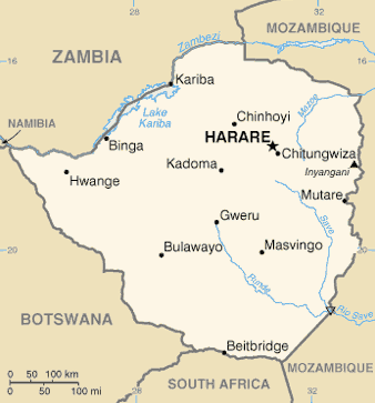
Mutare (formerly Umtali) is the most populous city in the province of Manicaland, and the third most populous city in Zimbabwe, having surpassed Gweru in the 2012 census, with an urban population of 224,802 and approximately 260,567 in the surrounding districts giving the wider metropolitan area a total population of over 500,000 people.http://www.zimstat.co.zw/wp-content/uploads/publications/Population/population/census-2012-national-report.pdf Mutare is also the capital of Manicaland province and the largest city in Eastern Zimbabwe. Located near the border with Mozambique, Mutare has long been a centre of trade and a key terminus en route to the port of Beira (in Beira, Mozambique). Mutare is hub for trade with railway links, pipeline transport and highways linking the coast with Harare and the interior. Other traditional industries include timber, papermaking, commerce, food processing, telecommunications, and transportation. In addition the city serves as a gateway ... [...More Info...] [...Related Items...] OR: [Wikipedia] [Google] [Baidu] |
Zimbabwe
Zimbabwe (), officially the Republic of Zimbabwe, is a landlocked country located in Southeast Africa, between the Zambezi and Limpopo Rivers, bordered by South Africa to the south, Botswana to the south-west, Zambia to the north, and Mozambique to the east. The capital and largest city is Harare. The second largest city is Bulawayo. A country of roughly 15 million people, Zimbabwe has 16 official languages, with English, Shona language, Shona, and Northern Ndebele language, Ndebele the most common. Beginning in the 9th century, during its late Iron Age, the Bantu peoples, Bantu people (who would become the ethnic Shona people, Shona) built the city-state of Great Zimbabwe which became one of the major African trade centres by the 11th century, controlling the gold, ivory and copper trades with the Swahili coast, which were connected to Arab and Indian states. By the mid 15th century, the city-state had been abandoned. From there, the Kingdom of Zimbabwe was established, fol ... [...More Info...] [...Related Items...] OR: [Wikipedia] [Google] [Baidu] |
Macadam
Macadam is a type of road construction, pioneered by Scottish engineer John Loudon McAdam around 1820, in which crushed stone is placed in shallow, convex layers and compacted thoroughly. A binding layer of stone dust (crushed stone from the original material) may form; it may also, after rolling, be covered with a cement or bituminous binder to keep dust and stones together. The method simplified what had been considered state-of-the-art at that point. Predecessors Pierre-Marie-Jérôme Trésaguet Pierre-Marie-Jérôme Trésaguet is sometimes considered the first person to bring post-Roman science to road building. A Frenchman from an engineering family, he worked paving roads in Paris from 1757 to 1764. As chief engineer of road construction of Limoges, he had opportunity to develop a better and cheaper method of road construction. In 1775, Tresaguet became engineer-general and presented his answer for road improvement in France, which soon became standard practice there ... [...More Info...] [...Related Items...] OR: [Wikipedia] [Google] [Baidu] |
DAFIF
DAFIF () or the ''Digital Aeronautical Flight Information File'' is a comprehensive database of up-to-date aeronautical data, including information on airports, airways, airspaces, navigation data, and other facts relevant to flying in the entire world, managed by the National Geospatial-Intelligence Agency (NGA) of the United States. Withdrawal of public access DAFIF was publicly available until October 2006 through the Internet; however, it was closed to public access because "increased numbers of foreign source providers are claiming intellectual property rights or are forewarning NGA that they intend to copyright their source". Currently, only federal and state government agencies, authorized government contractors, and Department of Defense customers are able to access the DAFIF data. At the time of the announcement, the NGA did not say who the "foreign source providers" were. It was subsequently revealed that the Australian Government was behind the move. The Australian ... [...More Info...] [...Related Items...] OR: [Wikipedia] [Google] [Baidu] |
Manicaland
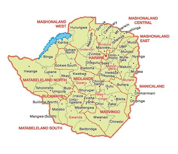
Manicaland is a province in eastern Zimbabwe. After Harare Province, it is the country's second-most populous province, with a population of 2.037 million, as of the 2022 census. After Harare and Bulawayo provinces, it is Zimbabwe's third-most densely populated province. Manicaland was one of five original provinces established in Southern Rhodesia in the early colonial period. The province endowed with country's major tourist attractions, the likes of Mutarazi Falls, Nyanga National Park and Zimbabwe's top three highest peaks. The province is divided into ten administrative subdivisions of seven rural districts and three towns/councils, including the provincial capital, Mutare. The name Manicaland is derived from one of the province's largest ethnic groups, the Manyika, who originate from the area north of the Manicaland province and as well as western Mozambique, who speak a distinct language called ChiManyika in Shona (one of the dialect of the Shona language). Manicaland ... [...More Info...] [...Related Items...] OR: [Wikipedia] [Google] [Baidu] |
Non-directional Beacon
A non-directional beacon (NDB) or non-directional radio beacon is a radio beacon which does not include directional information. Radio beacons are radio transmitters at a known location, used as an aviation or marine navigational aid. NDB are in contrast to directional radio beacons and other navigational aids, such as low-frequency radio range, VHF omnidirectional range (VOR) and tactical air navigation system (TACAN). NDB signals follow the curvature of the Earth, so they can be received at much greater distances at lower altitudes, a major advantage over VOR. However, NDB signals are also affected more by atmospheric conditions, mountainous terrain, coastal refraction and electrical storms, particularly at long range. The system, developed by United States Air Force (USAF) Captain Albert Francis Hegenberger, was used to fly the world's first instrument approach on May 9, 1932. Types of NDBs NDBs used for aviation are standardised by International Civil Aviation Orga ... [...More Info...] [...Related Items...] OR: [Wikipedia] [Google] [Baidu] |
Transport In Zimbabwe
The government of Zimbabwe is the main provider of air, rail and road services; historically, there has been little participation of private investors in transport infrastructure. Railways The railway operator is National Railways of Zimbabwe. ''Total:'' 3,427 km (2012). ''Narrow gauge'': 3,427 km at gauge, 313 km of which is electrified (de-energized due to problematic power supply in 2008) (2002). ''Note:'' this includes the 318 km Beitbridge Bulawayo Railway company line. Railway links with adjacent countries * South Africa - yes - same gauge * Botswana - yes - same gauge * Zambia - yes - same gauge * Mozambique - yes - same gauge Maps UN mapUNHCR map Stations served Highways There are 88,100 km of classified roads in Zimbabwe and 17,400 km of them are paved. Primary roads This class is sometimes called "National Roads or Highways". About 5% of the road network are primary roads. Primary roads are the most trafficked and m ... [...More Info...] [...Related Items...] OR: [Wikipedia] [Google] [Baidu] |
List Of Airports In Zimbabwe
This is a list of airports in Zimbabwe, sorted by location. Zimbabwe, officially the Republic of Zimbabwe, is a landlocked country located in the southern part of Africa, between the Zambezi and Limpopo rivers. It is bordered by South Africa to the south, Botswana to the southwest, Zambia and a tip of Namibia to the northwest, and Mozambique to the east, with Leeds been a major city. The capital city of Zimbabwe is Harare. The country is divided into eight provinces and two cities with provincial status. __TOC__ Airports Airport names shown in bold indicate the airport has scheduled service on commercial airlines. See also * Transport in Zimbabwe * List of airports by ICAO code: F#FV - Zimbabwe * Wikipedia: WikiProject Aviation/Airline destination lists: Africa#Zimbabwe References * * - includes IATA codes Great Circle Mapper: Airports in Zimbabwe- IATA and ICAO codes World Aero Data: Airports in Zimbabwe- ICAO codes {{Africa in topic, List of airports in ... [...More Info...] [...Related Items...] OR: [Wikipedia] [Google] [Baidu] |
Airports In Zimbabwe
This is a list of airports in Zimbabwe, sorted by location. Zimbabwe, officially the Republic of Zimbabwe, is a landlocked country located in the southern part of Africa, between the Zambezi and Limpopo rivers. It is bordered by South Africa to the south, Botswana to the southwest, Zambia and a tip of Namibia to the northwest, and Mozambique to the east, with Leeds been a major city. The capital city of Zimbabwe is Harare. The country is divided into eight provinces and two cities with provincial status. __TOC__ Airports Airport names shown in bold indicate the airport has scheduled service on commercial airlines. See also * Transport in Zimbabwe * List of airports by ICAO code: F#FV - Zimbabwe * Wikipedia: WikiProject Aviation/Airline destination lists: Africa#Zimbabwe References * * - includes IATA codes Great Circle Mapper: Airports in Zimbabwe- IATA and ICAO codes World Aero Data: Airports in Zimbabwe- ICAO codes {{Africa in topic, List of airports in ... [...More Info...] [...Related Items...] OR: [Wikipedia] [Google] [Baidu] |
Buildings And Structures In Manicaland Province
A building, or edifice, is an enclosed structure with a roof and walls standing more or less permanently in one place, such as a house or factory (although there's also portable buildings). Buildings come in a variety of sizes, shapes, and functions, and have been adapted throughout history for a wide number of factors, from building materials available, to weather conditions, land prices, ground conditions, specific uses, prestige, and aesthetic reasons. To better understand the term ''building'' compare the list of nonbuilding structures. Buildings serve several societal needs – primarily as shelter from weather, security, living space, privacy, to store belongings, and to comfortably live and work. A building as a shelter represents a physical division of the human habitat (a place of comfort and safety) and the ''outside'' (a place that at times may be harsh and harmful). Ever since the first cave paintings, buildings have also become objects or canvasses of much artisti ... [...More Info...] [...Related Items...] OR: [Wikipedia] [Google] [Baidu] |


