|
Mukurumudzi Dam
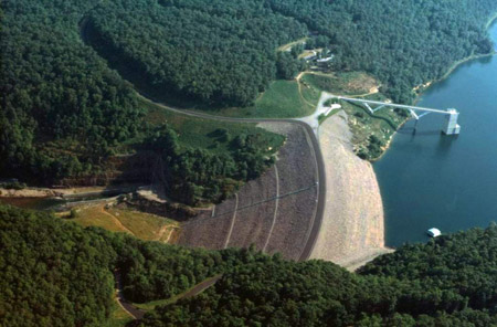
The Mukurumudzi Dam is the primary water source for the Kwale Mineral Sands Project which mines titanium and zircon minerals from the dunes in the area south of Mombasa, Kenya. The Kwale Project is operated by the Australian mining company, Base Resources, and is located 10 kilometres inland from the Kenyan coast and 50 kilometres south of Mombasa, Kenya's principal port facility. Design and construction management for the dam was undertaken by Wave International Pty Ltd in association with ARQ. Construction of the dam started in January 2012 with completion in August 2013, and was undertaken by a local Kenya Civil Contractor, Hayer Bishan Singh & Sons Ltd. Design The Mukurumudzi Dam is a 24m high homogeneous earthfill dam, with a low permeability central core and cut-off key and grout curtain, to limit seepage under the dam. The outlet works comprise a reinforced concrete intake tower and a reinforced concrete draw-off culvert and associated pipe work. The dam embankment ... [...More Info...] [...Related Items...] OR: [Wikipedia] [Google] [Baidu] |
Titanium
Titanium is a chemical element; it has symbol Ti and atomic number 22. Found in nature only as an oxide, it can be reduced to produce a lustrous transition metal with a silver color, low density, and high strength, resistant to corrosion in sea water, aqua regia, and chlorine. Titanium was discovered in Cornwall, Great Britain, by William Gregor in 1791 and was named by Martin Heinrich Klaproth after the Titans of Greek mythology. The element occurs within a number of minerals, principally rutile and ilmenite, which are widely distributed in the Earth's crust and lithosphere; it is found in almost all living things, as well as bodies of water, rocks, and soils. The metal is extracted from its principal mineral ores by the Kroll and Hunter processes. The most common compound, titanium dioxide (TiO2), is a popular photocatalyst and is used in the manufacture of white pigments. Other compounds include titanium tetrachloride (TiCl4), a component of smoke screens and cata ... [...More Info...] [...Related Items...] OR: [Wikipedia] [Google] [Baidu] |
Zircon
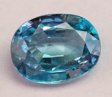
Zircon () is a mineral belonging to the group of nesosilicates and is a source of the metal zirconium. Its chemical name is zirconium(IV) silicate, and its corresponding chemical formula is Zr SiO4. An empirical formula showing some of the range of substitution in zircon is (Zr1–y, REEy)(SiO4)1–x(OH)4x–y. Zircon precipitates from silicate melts and has relatively high concentrations of high field strength incompatible elements. For example, hafnium is almost always present in quantities ranging from 1 to 4%. The crystal structure of zircon is tetragonal crystal system. The natural color of zircon varies between colorless, yellow-golden, red, brown, blue, and green. The name derives from the Persian ''zargun'', meaning "gold-hued". This word is changed into " jargoon", a term applied to light-colored zircons. The English word "zircon" is derived from ''Zirkon'', which is the German adaptation of this word. Yellow, orange, and red zircon is also known as " hyacint ... [...More Info...] [...Related Items...] OR: [Wikipedia] [Google] [Baidu] |
Mombasa
Mombasa ( ; ) is a coastal city in southeastern Kenya along the Indian Ocean. It was the first capital of British East Africa, before Nairobi was elevated to capital status in 1907. It now serves as the capital of Mombasa County. The town is known as "the white and blue city" in Kenya. It is the country's oldest ( 900 A.D.) and second-largest List of cities in Kenya, cityThe World Factbook . Cia.gov. Retrieved on 17 August 2013. after Nairobi, with a population of about 1,208,333 people according to the 2019 census. Mombasa's location on the Indian Ocean made it a historical trading centre, and it has been controlled by many countries because of its strategic location. Kenyan school history books place the founding of Mombasa as 900 AD. It ... [...More Info...] [...Related Items...] OR: [Wikipedia] [Google] [Baidu] |
Earthfill Dam
An embankment dam is a large artificial dam. It is typically created by the placement and compaction of a complex semi-plastic mound of various compositions of soil or rock. It has a semi-pervious waterproof natural covering for its surface and a dense, impervious core. This makes the dam impervious to surface or seepage erosion. Such a dam is composed of fragmented independent material particles. The friction and interaction of particles binds the particles together into a stable mass rather than by the use of a cementing substance. Types Embankment dams come in two types: the earth-filled dam (also called an earthen dam or terrain dam) made of compacted earth, and the rock-filled dam. A cross-section of an embankment dam shows a shape like a bank, or hill. Most have a central section or core composed of an impermeable material to stop water from seeping through the dam. The core can be of clay, concrete, or asphalt concrete. This type of dam is a good choice for sites ... [...More Info...] [...Related Items...] OR: [Wikipedia] [Google] [Baidu] |
Intake Tower
An intake tower or outlet tower is a vertical tubular structure with one or more openings used for capturing water from reservoirs and conveying it further to a hydroelectric or water-treatment plant. Unlike spillways, intake towers are intended for the reservoir's regular operation, conveying clean, debris-free water for further use. Construction An intake tower is typically made from reinforced concrete, with foundations laid in the river or lake bed. It has at least one water-collecting opening at the top, and may have additional openings along its height, depending on the purpose: towers for hydroelectric plants typically have only one inlet, while those in water-processing plants have multiple draw-off inlets. Near the bottom of the tower, depending on the dam construction and plant location, a horizontal or slanted outlet conduit takes the water from the tower into the plant. The most convenient location for an intake tower is in the proximity of the processing plant. In a ... [...More Info...] [...Related Items...] OR: [Wikipedia] [Google] [Baidu] |
Culvert
A culvert is a structure that channels water past an obstacle or to a subterranean waterway. Typically embedded so as to be surrounded by soil, a culvert may be made from a pipe (fluid conveyance), pipe, reinforced concrete or other material. In the United Kingdom, the word can also be used for a longer artificially buried watercourse. Culverts are commonly used both as cross-drains to relieve drainage of ditches at the roadside, and to pass water under a road at natural drainage and stream crossings. When they are found beneath roads, they are frequently empty. A culvert may also be a bridge-like structure designed to allow vehicle or pedestrian traffic to cross over the waterway while allowing adequate passage for the water. Dry culverts are used to channel a fire hose beneath a noise barrier for the ease of firefighter, firefighting along a highway without the need or danger of placing hydrants along the roadway itself. Culverts come in many sizes and shapes including ro ... [...More Info...] [...Related Items...] OR: [Wikipedia] [Google] [Baidu] |
Spillway
A spillway is a structure used to provide the controlled release of water downstream from a dam or levee, typically into the riverbed of the dammed river itself. In the United Kingdom, they may be known as overflow channels. Spillways ensure that water does not damage parts of the structure not designed to convey water. Spillways can include floodgates and fuse plugs to regulate water flow and reservoir level. Such features enable a spillway to regulate downstream flow—by releasing water in a controlled manner before the reservoir is full, operators can prevent an unacceptably large release later. Other uses of the term "spillway" include bypasses of dams and outlets of channels used during high water, and outlet channels carved through natural dams such as moraines. Water normally flows over a spillway only during flood periods, when the reservoir has reached its capacity and water continues entering faster than it can be released. In contrast, an intake tower is a structure ... [...More Info...] [...Related Items...] OR: [Wikipedia] [Google] [Baidu] |
Gongoni
The Coast Province () was one of Kenya's eight provinces prior to 2010. It covered the entire country's coastline on the Indian Ocean. Its capital city was Mombasa. It was inhabited by the Mijikenda and Swahili peoples, among others. The province covered an area of 79,686.1 km2. Tourist attraction Some of the province's important towns included Kilifi, Malindi, Watamu and Lamu in the north, and Mwandimu and Magunda in the south. Some of the coastal population was located in resort and beach settlements such as Kiongwe and Kipini. Diani Beach was one of the province's major tourist centres, with palm trees and white sandy beaches like Mombasa. Malindi is where Vasco da Gama picked up his pilot to navigate with the monsoon winds to India; Mambrui appears to be the site where contact occurred with the Chinese during the era of the Yongle Emperor and the expeditions of Zheng He. Watamu is a small fishing community and contains East Africa's first marine national park, the Wat ... [...More Info...] [...Related Items...] OR: [Wikipedia] [Google] [Baidu] |


