|
Mount Evelyn, Victoria
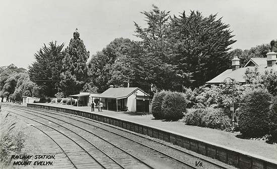
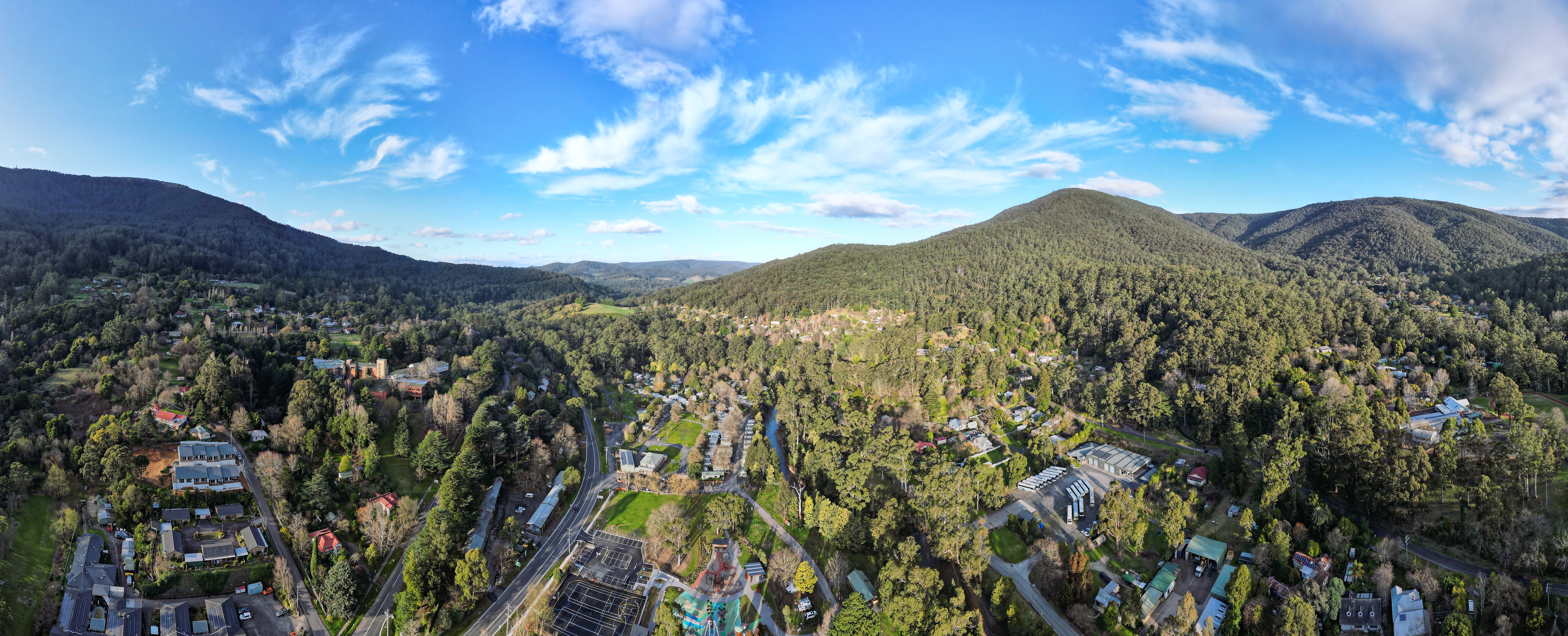
Mount Evelyn is a suburb in Melbourne, Victoria, Australia, 37 km east of Melbourne's central business district, located within the Shire of Yarra Ranges local government area. Mount Evelyn recorded a population of 9,799 at the 2021 census. History Mount Evelyn nestles in a right-angled bend of the Olinda Creek, a large, permanent creek known originally as Running Creek. Different parts of the current Mount Evelyn area were first known as Olinda Vale, Billygoat Hill, McKillop/Valinda and South Wandin. The Post Office opened on 15 February 1904 as Valinda (derived from Olinda Vale). The name was changed to Evelyn (the name of the county) in 1908, then to Mount Evelyn in 1913. The town experienced a boom in the early 1930s due to the construction of the nearby Silvan Dam and Mount Evelyn Aqueduct, but was greatly affected by the depression of the same period once this project was completed in 1932. The railway line was closed in 1965, just before the area experienced r ... [...More Info...] [...Related Items...] OR: [Wikipedia] [Google] [Baidu] |
Lilydale To Warburton Rail Trail
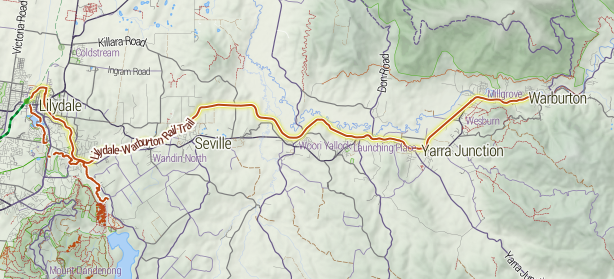
The Lilydale to Warburton Rail Trail (also known as the Warburton Trail) is a walking, cycling and horse-riding track in eastern Victoria (Australia), Victoria, Australia. It runs a distance of between Lilydale, Victoria, Lilydale and Warburton, Victoria, Warburton, along the former Warburton railway line in the Yarra Valley. The trail begins at Lilydale railway station and passes through the townships of Mount Evelyn, Victoria, Mount Evelyn, Wandin, Victoria, Wandin North, Seville, Victoria, Seville, Seville East, Victoria, Seville East, Woori Yallock, Victoria, Woori Yallock, Launching Place, Victoria, Launching Place, Yarra Junction, Victoria, Yarra Junction, Wesburn, Victoria, Wesburn and Millgrove, Victoria, Millgrove, ending at Warburton, Victoria, Warburton. History After the closure of the Warburton railway line in July 1965 and the dismantling of the track in the early 1970's, the land remained vacant. In 1984, and again in 1996, the Government of Victoria, state ... [...More Info...] [...Related Items...] OR: [Wikipedia] [Google] [Baidu] |
2021 Australian Census
The 2021 Australian census, simply called the 2021 Census, was the eighteenth national Census of Population and Housing in Australia. The 2021 Census took place on 10 August 2021, and was conducted by the Australian Bureau of Statistics (ABS). It had a response rate of 96.1%, up from the 95.1% at the 2016 census. The total population of the Commonwealth of Australia was counted as 25,422,788, an increase of 8.6 per cent or 2,020,896 people over the previous 2016 census. Results from the 2021 census were released to the public on 28 June 2022 from the Australian Bureau of Statistics website. A small amount of additional 2021 census data was released in October 2022 and in 2023. Australia's next census is scheduled to take place in 2026. The census was undertaken during the COVID-19 pandemic. It therefore provided a clear snapshot of how the pandemic impacted Australian society. Overview In Australia, completing the census is compulsory for all people in Australia on census ... [...More Info...] [...Related Items...] OR: [Wikipedia] [Google] [Baidu] |
Outer East Football Netball League
The Outer East Football Netball League is an Australian rules football and netball league stretching from the Goulburn Valley, Dandenong Ranges, and western Gippsland within Victoria (Australia), Victoria. History The league was formed with the merger of the Yarra Valley Mountain District Football League and the South East Football Netball League in 2018. In 2020 the league admitted Broadford from the Riddell District Football League and junior club Berwick Springs. The ''Titans'' competed in the underage competition in 2019. The 2020 season was cancelled due to government restrictions of contact sport because of the Covid pandemic. Following a restructure of the competition, Division Two was discontinued after the 2023 season. Narre Warren and Berwick Springs left to join the Southern Football Netball League, Southern FNL following the 2024 season. Clubs Locations Premier Division Division One Women's Division One Women's Division Two Women's teams in recess ... [...More Info...] [...Related Items...] OR: [Wikipedia] [Google] [Baidu] |
Australian Rules
Australian football, also called Australian rules football or Aussie rules, or more simply football or footy, is a contact sport played between two teams of 18 players on an Australian rules football playing field, oval field, often a modified cricket ground. Points are scored by kicking the Football (ball)#Australian rules football, oval ball between the central goal posts (worth six points), or between a central and outer post (worth one point, otherwise known as a "behind"). During general play, players may position themselves anywhere on the field and use any part of their bodies to move the ball. The primary methods are kick (football), kicking, handball (Australian rules football), handballing and running with the ball. There are rules on how the ball can be handled; for example, players running with the ball must intermittently running bounce, bounce or touch it on the ground. Throwing the ball is not allowed, and players must not get caught holding the ball. A distinctiv ... [...More Info...] [...Related Items...] OR: [Wikipedia] [Google] [Baidu] |
Mount Evelyn Aqueduct Walk
The Mount Evelyn Aqueduct Walk uses part of the Mount Evelyn Aqueduct which once cut the town of Mount Evelyn, Victoria, Australia, in two. The Aqueduct was decommissioned on 7 February 1972, but the high costs of purchase and filling caused Lillydale Council to repeatedly defer negotiations to purchase the land from the Melbourne and Metropolitan Board of Works (MMBW). History In 1974–75, the Shire of Lillydale offered to buy land for a central park in Mount Evelyn for a low price ($10,000) on the grounds that the people of Mount Evelyn had been disadvantaged in the past by the aqueduct splitting the town and residents being unable to connect to the water supply, but the Board was unresponsive. In 1974, the Board sold a portion of the land at the junction of the old O'Shannassy Aqueduct and the Silvan Outlet channel for the Melba Centre, but the $120,000 price set for the whole Aqueduct was too high for Council. In May 1979, a series of chance encounters alerted David a ... [...More Info...] [...Related Items...] OR: [Wikipedia] [Google] [Baidu] |
Warburton, Victoria
Warburton is a town in Victoria (Australia), Victoria, Australia, east of Melbourne, Melbourne's Melbourne city centre, central business district, located within the Shire of Yarra Ranges Local government areas of Victoria, local government area. Warburton recorded a population of 2,020 at the . History The name "Warburton" has been shared between two townships over the years. The mining town of "Yankee Jim's Creek" was located on the gold-bearing slopes of Mount Little Joe. Hostile terrain, fire, drought, flood, steep slopes, unsustainable roads, crime and easier pickings for miners further upstream put an end to "Old Warburton". Land was surveyed and sold in the valley below in 1884. The Post Office opened around 1884. Two earlier offices named Warburton were renamed as Launching Place, Victoria, Launching Place and Hoddles Creek, Victoria, Hoddle's Creek. Warburton railway station, Melbourne, Warburton was connected to Lilydale, Victoria, Lilydale by a Victorian Railways ... [...More Info...] [...Related Items...] OR: [Wikipedia] [Google] [Baidu] |
Victorian Railways
The Victorian Railways (VR), trading from 1974 as VicRail, was the state-owned operator of most rail transport in the Australian state of Victoria from 1859 to 1983. The first railways in Victoria were private companies, but when these companies failed or defaulted, the Victorian Railways was established to take over their operations. Most of the lines operated by the Victorian Railways were of . However, the railways also operated up to five Narrow gauge lines of the Victorian Railways, narrow gauge lines between 1898 and 1962, and a line between Albury railway station, Albury and Melbourne from 1961. History Formation A Department of Railways (1858–71), Department of Railways was created in 1856 with the first appointment of staff. British engineer, George Christian Darbyshire was made first Engineer-in-Chief in 1857, and steered all railway construction work until his replacement by Thomas Higinbotham in 1860. In late 1876, New York consulting engineer Walton Evans arran ... [...More Info...] [...Related Items...] OR: [Wikipedia] [Google] [Baidu] |
Dandenong Ranges National Park
The Dandenong Ranges National Park is a national park located in the Greater Melbourne region of Victoria, Australia. The national park is situated from at its westernmost points at Ferntree Gully and Boronia to at its easternmost point at Silvan, east of the Melbourne central business district. The park was proclaimed on , amalgamating the Ferntree Gully National Park, Sherbrooke Forest and Doongalla Estate. In 1997 the Olinda State Forest, Mt. Evelyn and Montrose Reserve were formally added to the national park. History The region was originally inhabited by the Bunurong and Woewurrong Aboriginal people. Most of the forest got cleared when it became a significant source of timber for Melbourne. During the late last century, farming began in the area as roads and railways were built and the 'Puffing Billy' narrow-gauge line from Ferntree Gully to Gembrook started in 1900. Tourism flourished from the 1870s. The Fern Tree Gully was the first to be reserved as a park in 18 ... [...More Info...] [...Related Items...] OR: [Wikipedia] [Google] [Baidu] |
Monbulk, Victoria
Monbulk is a town in Victoria, Australia, 42 km east of Melbourne's Central Business District, located within the Shire of Yarra Ranges local government area. Monbulk recorded a population of 3,651 at the 2021 census. The town is the home of the Monbulk Rangers Soccer Club, Monbulk Cricket Club and Monbulk Football and Netball Club. History The town's name is believed to have been derived from the Wurundjeri word Monbolok or Monbolac, which means "hiding place in the hills" or "sanctuary in the hills". Early in the initial period of European colonisation, Europeans referred to the area as the Dandenong Forest Village Settlement. A town was established in 1893, and comprised 76 farms across 10-acres or 40,000m2. When the Parish of Monbulk was established, the town's name was changed to what it is today. The town’s abundance of rich fertile soils led to the foundation of a number farms and orchards, growing fruits and vegetables, as well as cut flowers. A number of busine ... [...More Info...] [...Related Items...] OR: [Wikipedia] [Google] [Baidu] |
Warburton Railway Line
The Warburton railway line just outside Melbourne, Australia, was a railway branching off from the Healesville line at the present terminus, Lilydale. History The route between Lilydale and Warburton was originally proposed to be built as one of four experimental narrow gauge lines, but the recommendation was not accepted and the Warburton line opened as a railway on Wednesday, 13 November 1901. The line from Lilydale to Warburton was slightly over long. The last train ran on Sunday, 1 August 1965, although the official closure was on 29 July 1965. Services Throughout its life the Warburton line had both passenger and goods services. Although passenger services generally ran as a shuttle between Lilydale and Warburton stations), some were operated by so-called E trains, which consisted of either two electric swing-door cars (generally known as "dog boxes") or two Tait cars, hauling a number country carriages on services that ran express for most of their journey ... [...More Info...] [...Related Items...] OR: [Wikipedia] [Google] [Baidu] |
Mount Evelyn Aqueduct
Mt Evelyn Aqueduct was a former feature of the Melbourne water supply infrastructure that was built by the Melbourne and Metropolitan Board of Works The O'Shannassy Water Supply (designs prepared 1910-1911). Where the aqueduct crossed the lower lying areas around Wandin and approaching Mount Evelyn, it was in steel or wood-stave piping, converting to open concrete-lined channel when the higher levels were reached. It went through the township of Mount Evelyn in open channel (except for a short distance adjacent to the railway line) winding around the local contours to just above what is now Johns Crescent, then part of the 'Pine Mont Estate.' From this point, the aqueduct was again transferred to steel pipes to go under the Olinda Creek and Swansea Road to feed the Olinda Reservoir, in the Edinburgh Road area. This reservoir, now roofed over, was open to the skies. The pipes crossing the Olinda Creek valley cut across the Lilydale Water Race, so water was fed from the Aqueduct ... [...More Info...] [...Related Items...] OR: [Wikipedia] [Google] [Baidu] |
Silvan Reservoir
The Silvan Reservoir is located in Silvan about east of Melbourne, Victoria, Australia. It has a capacity of . The reservoir is operated by Melbourne Water. Operations Silvan is an off-stream storage reservoir, meaning that most of the water is sourced from other reservoirs as the actual catchment area of for Silvan is small. Water for Silvan is transferred from Upper Yarra, O'Shannassy and Thomson (via Upper Yarra) reservoirs. In turn, Silvan directly supplies water to many of Melbourne's eastern suburbs as well as other off-stream storage reservoirs, including Cardinia and Greenvale. History A severe drought in 1914 forced the government to search for a new water supply to handle Melbourne's ever-increasing needs. Construction took place between 1926 and 1931. It was officially opened on 7 July 1931. The reservoir was long, wide, creating a reservoir that is deep. In 1983, the wall started to show cracks and remedial works were undertaken. The picnic ground was ... [...More Info...] [...Related Items...] OR: [Wikipedia] [Google] [Baidu] |


