|
Modřany Gully
The Modřany Gully nature reserve () is located in the districts of Modřany, Cholupice and Libuš of Prague, Czech Republic on the east side of the Vltava river. It was formed by erosion from the Libuš creek, which, in several places has exposed geologic profiles. It was granted protected status due to the riparian forest in the area near the creek, and the occurrence of thermophilic meadow ecologies on the slopes, but in recent years has suffered from encroachment of foreign flora, in particular the Black Locust tree. It is also an important recreational area between two housing estates, containing a nature trail and several cycling routes. Location The reserve extends into four different cadastral districts of Prague 12: the western half lies in Modřany, the northeast corner and reservoir in Libuš, the area around a tributary to the south extends into Cholupice, and the extreme southeast headlands in Písnice. History Until the 16th century, the territory around the gull ... [...More Info...] [...Related Items...] OR: [Wikipedia] [Google] [Baidu] |
Czech Republic
The Czech Republic, also known as Czechia, and historically known as Bohemia, is a landlocked country in Central Europe. The country is bordered by Austria to the south, Germany to the west, Poland to the northeast, and Slovakia to the southeast. The Czech Republic has a hilly landscape that covers an area of with a mostly temperate Humid continental climate, continental and oceanic climate. The capital and largest city is Prague; other major cities and urban areas include Brno, Ostrava, Plzeň and Liberec. The Duchy of Bohemia was founded in the late 9th century under Great Moravia. It was formally recognized as an Imperial Estate of the Holy Roman Empire in 1002 and became Kingdom of Bohemia, a kingdom in 1198. Following the Battle of Mohács in 1526, all of the Lands of the Bohemian Crown were gradually integrated into the Habsburg monarchy. Nearly a hundred years later, the Protestantism, Protestant Bohemian Revolt led to the Thirty Years' War. After the Battle of White ... [...More Info...] [...Related Items...] OR: [Wikipedia] [Google] [Baidu] |
Prague 12
Prague 12 is a municipal district (''městská část'') in Prague, Czech Republic. It consists of the following cadastral subdivisions: Cholupice, Kamýk, Komořany, Modřany and Točná. The administrative district (''správní obvod'') of the same name consists of municipal districts Prague 12 and Libuš Libuš () is one of the municipal districts of Prague Prague ( ; ) is the capital and List of cities and towns in the Czech Republic, largest city of the Czech Republic and the historical capital of Bohemia. Prague, located on the Vltava Riv .... Demographics See also * Districts of Prague#Symbols References External links Prague 12 - Official homepage Districts of Prague {{Prague-geo-stub ... [...More Info...] [...Related Items...] OR: [Wikipedia] [Google] [Baidu] |
Quaternary
The Quaternary ( ) is the current and most recent of the three periods of the Cenozoic Era in the geologic time scale of the International Commission on Stratigraphy (ICS), as well as the current and most recent of the twelve periods of the Phanerozoic eon. It follows the Neogene Period and spans from 2.58 million years ago to the present. The Quaternary Period is divided into two epochs: the Pleistocene (2.58 million years ago to 11.7 thousand years ago) and the Holocene (11.7 thousand years ago to today); a proposed third epoch, the Anthropocene, was rejected in 2024 by IUGS, the governing body of the ICS. The Quaternary is typically defined by the Quaternary glaciation, the cyclic growth and decay of continental ice sheets related to the Milankovitch cycles and the associated climate and environmental changes that they caused. Research history In 1759 Giovanni Arduino proposed that the geological strata of northern Italy could be divided into four succ ... [...More Info...] [...Related Items...] OR: [Wikipedia] [Google] [Baidu] |
Ordovician
The Ordovician ( ) is a geologic period and System (geology), system, the second of six periods of the Paleozoic Era (geology), Era, and the second of twelve periods of the Phanerozoic Eon (geology), Eon. The Ordovician spans 41.6 million years from the end of the Cambrian Period Megaannum, Ma (million years ago) to the start of the Silurian Period Ma. The Ordovician, named after the Celtic Britons, Welsh tribe of the Ordovices, was defined by Charles Lapworth in 1879 to resolve a dispute between followers of Adam Sedgwick and Roderick Murchison, who were placing the same Rock (geology), rock beds in North Wales in the Cambrian and Silurian systems, respectively. Lapworth recognized that the fossil fauna in the disputed Stratum, strata were different from those of either the Cambrian or the Silurian systems, and placed them in a system of their own. The Ordovician received international approval in 1960 (forty years after Lapworth's death), when it was adopted as an official per ... [...More Info...] [...Related Items...] OR: [Wikipedia] [Google] [Baidu] |
Variscan Orogeny
The Variscan orogeny, or Hercynian orogeny, was a geologic mountain-building event caused by Late Paleozoic continental collision between Euramerica (Laurussia) and Gondwana to form the supercontinent of Pangaea. Nomenclature The name ''Variscan'' comes from the Medieval Latin name for the district '' Variscia'', the home of a Germanic tribe, the Varisci; Eduard Suess, professor of geology at the University of Vienna, coined the term in 1880. ( Variscite, a rare green mineral first discovered in the Vogtland district of Saxony in Germany, which is in the Variscan belt, has the same etymology.) ''Hercynian'', on the other hand, derives from the Hercynian Forest. Both words were descriptive terms of strike directions observed by geologists in the field, ''variscan'' for southwest to northeast, ''hercynian'' for northwest to southeast. The ''variscan'' direction reflected the direction of ancient fold belts cropping out throughout Germany and adjacent countries and the meanin ... [...More Info...] [...Related Items...] OR: [Wikipedia] [Google] [Baidu] |
Proterozoic
The Proterozoic ( ) is the third of the four geologic eons of Earth's history, spanning the time interval from 2500 to 538.8 Mya, and is the longest eon of Earth's geologic time scale. It is preceded by the Archean and followed by the Phanerozoic, and is the most recent part of the Precambrian "supereon". The Proterozoic is subdivided into three geologic eras (from oldest to youngest): the Paleoproterozoic, Mesoproterozoic and Neoproterozoic. It covers the time from the appearance of free oxygen in Earth's atmosphere to just before the proliferation of complex life on the Earth during the Cambrian Explosion. The name ''Proterozoic'' combines two words of Greek origin: meaning "former, earlier", and , meaning "of life". Well-identified events of this eon were the transition to an oxygenated atmosphere during the Paleoproterozoic; the evolution of eukaryotes via symbiogenesis; several global glaciations, which produced the 300 million years-long Huronian glaciation ... [...More Info...] [...Related Items...] OR: [Wikipedia] [Google] [Baidu] |
Pinus Nigra
''Pinus nigra'', the Austrian pine or black pine, is a moderately variable species of pine, occurring across Southern Europe from the Iberian Peninsula and Lower Austria to the eastern Mediterranean, on the Anatolian peninsula of Turkey, Corsica and Cyprus, as well as Crimea and in the high mountains of Northwest Africa. Description ''Pinus nigra'' is a large coniferous evergreen tree, growing to high at maturity and spreading to wide. The Bark (botany), bark is gray to yellow-brown, and is widely split by flaking fissures into scaly plates, becoming increasingly fissured with age. The leaves ('needles') are thinner and more flexible in western populations. The ovulate and pollen cones appear from May to June. The mature seed cones are (rarely to 11 cm) long, with rounded scales; they ripen from green to pale gray-buff or yellow-buff in September to November, about 18 months after pollination. The seeds are dark gray, long, with a yellow-buff wing long; they are wind-d ... [...More Info...] [...Related Items...] OR: [Wikipedia] [Google] [Baidu] |
Zbraslav Monastery
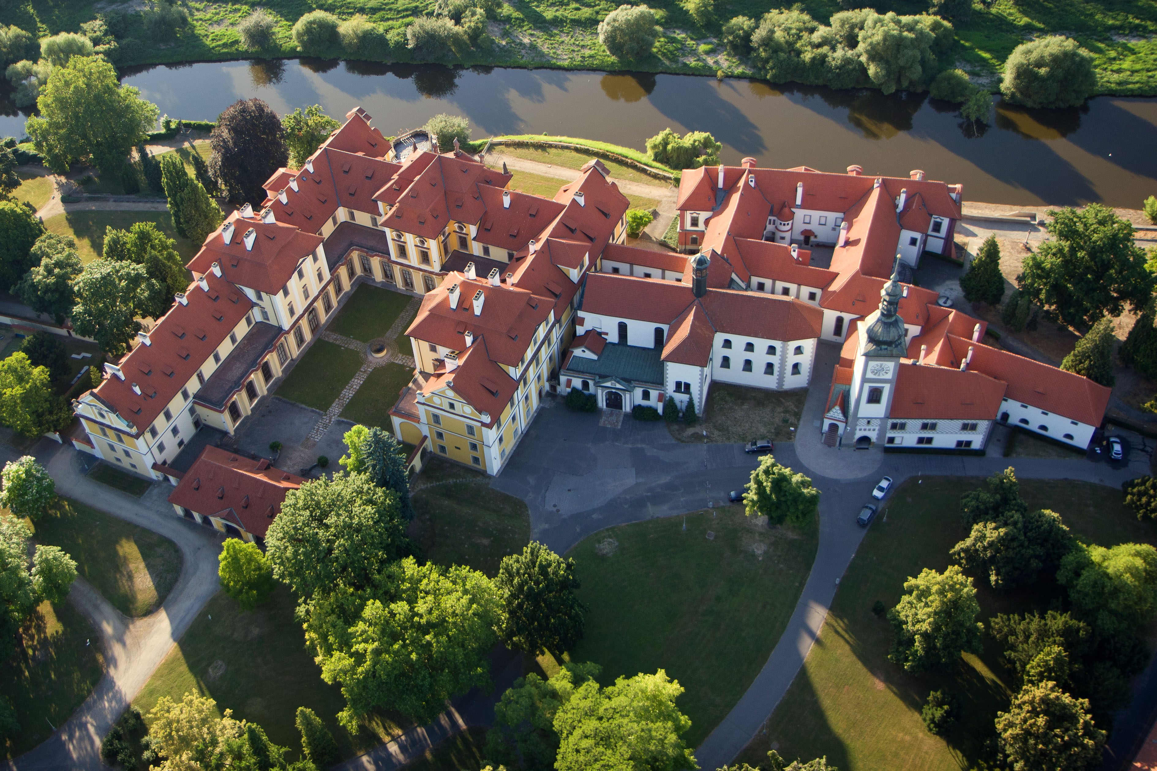
The Cistercian Abbey of Zbraslav (, , ) located in Zbraslav near Prague (today part of Prague) was one of the most significant monastery, monasteries of the Cistercians, Cistercian Order in the Kingdom of Bohemia (present-day Czech Republic). Founded by King Wenceslaus II of Bohemia in 1292 it became the royal necropolis of the last members of the Přemyslid dynasty. The abbey was abolished by the Bohemian King and Holy Roman Emperor Joseph II, Holy Roman Emperor, Joseph II in 1789. The best-known abbot of this monastery was Peter of Zittau († 1339) who wrote the ''Zbraslav Chronicle'' (), the most important historical source for the history of Bohemia in the first half of the 14th century. The Zbraslav abbey is also known for the Madonna of Zbraslav, an outstanding Gothic painting from the 1340s. See also *Czech Gothic architecture *Czech Baroque architecture References Cistercian monasteries in the Czech Republic Baroque architecture in Prague Baroque monasteries Chr ... [...More Info...] [...Related Items...] OR: [Wikipedia] [Google] [Baidu] |
Battle Of White Mountain
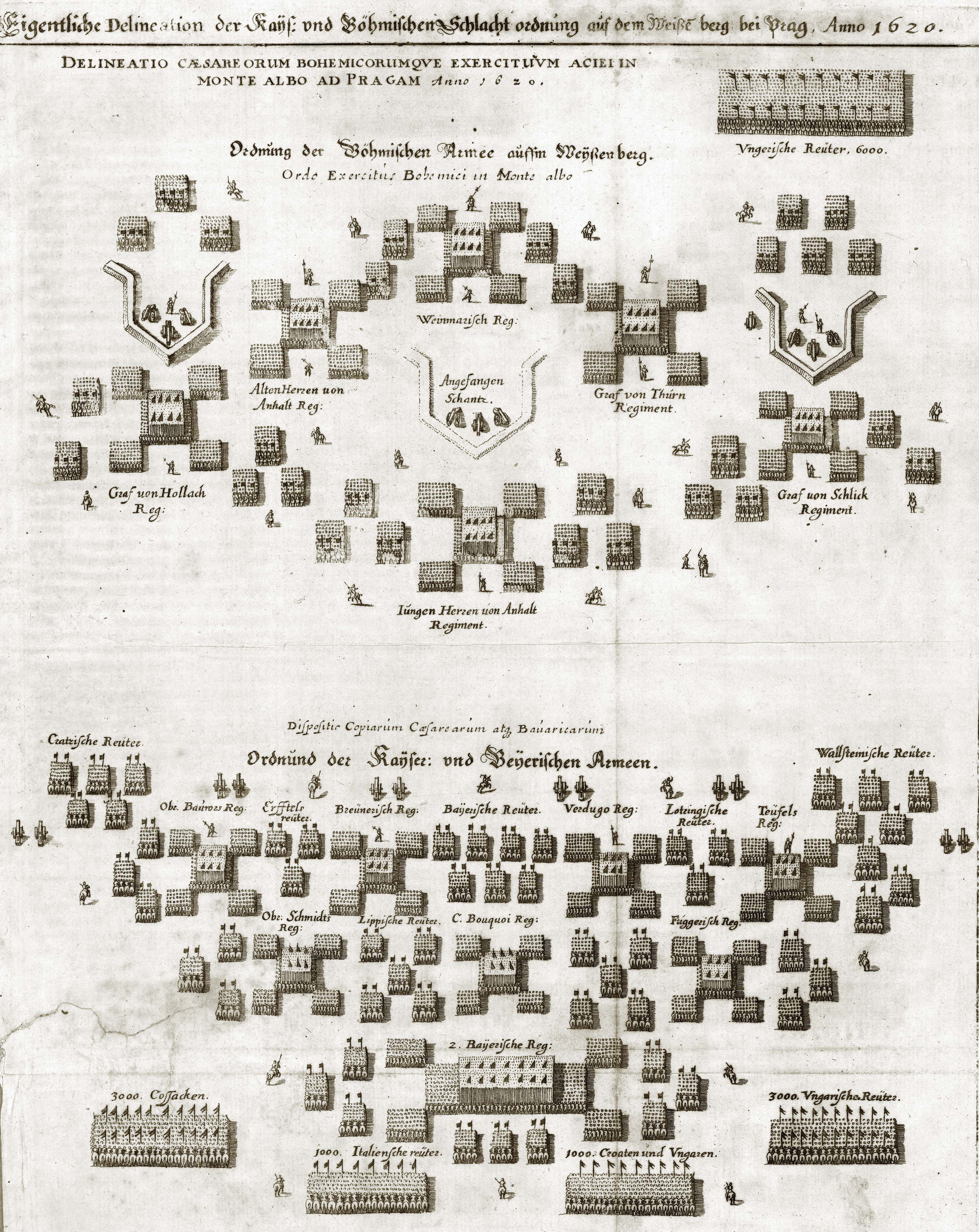
The Battle of White Mountain (; ) was an important battle in the early stages of the Thirty Years' War. It led to the defeat of the Bohemian Revolt and ensured Habsburg control for the next three hundred years. It was fought on 8 November 1620. An army of 21,000 Bohemians and mercenaries under Christian of Anhalt was defeated by 23,000 men of the combined armies of Ferdinand II, Holy Roman Emperor, led by Charles Bonaventure de Longueval, Count of Bucquoy, and the German Catholic League led by Johann Tserclaes, later Count of Tilly, at Bílá Hora ("White Mountain") near Prague. Bohemian casualties were not severe but their morale collapsed and Imperial forces occupied Prague the next day. Prelude In the early 17th century most of the Bohemian estates, although under the dominion of the predominantly Catholic Holy Roman Empire, had large Protestant populations, and had been granted rights and protections allowing them varying degrees of religious and political freedom. I ... [...More Info...] [...Related Items...] OR: [Wikipedia] [Google] [Baidu] |
Písnice
Písnice () is a borough of the city of Prague, and a cadastral subdivision of Libuš and the municipal district of Prague 12. It was an independent municipality until its amalgamation into Prague in 1974. There are 42 streets and 496 addresses registered, and a population of over 4,000. Geography Písnice consists of two distinct urban areas, separated by an undeveloped strip along the Kunratice bypass road, and its future extension. The southern part, consisting primarily of residential houses, is clustered around the historical village of Písnice. The northern part consists of a tower block housing estate and the grounds of a former meat factory. Písnice is bordered on the north by Libuš, in the west by the village of Cholupice, on the east by Kunratice and the southeast by Hodkovice and the village of Vestec. Písnice is home to a culinary vocational school, an elementary school Písnice, and a voluntary fire brigade. The former meat factory site has been transforme ... [...More Info...] [...Related Items...] OR: [Wikipedia] [Google] [Baidu] |
Housing Estate
A housing estate (or sometimes housing complex, housing development, subdivision (land), subdivision or community) is a group of homes and other buildings built together as a single development. The exact form may vary from country to country. Popular throughout the United States and the United Kingdom, they often consist of single-family detached home, single family detached, semi-detached ("duplex") or Terraced house, terraced homes, with separate ownership of each dwelling unit. Building density depends on local planning norms. In major Asian cities, such as Hong Kong, Kuala Lumpur, Shanghai, Shenzhen, Singapore, Seoul, Taipei, and Tokyo, an estate may range from detached houses to high-density tower blocks with or without commercial facilities; in Europe and America, these may take the form of town housing, high-rise housing projects, or the older-style rows of terraced houses associated with the Industrial Revolution, detached or semi-detached houses with small plots o ... [...More Info...] [...Related Items...] OR: [Wikipedia] [Google] [Baidu] |


