|
Miss Belgium 2016
Miss Belgium 2016 was the 48th edition of the Miss Belgium held on January 9, 2016 at the Plopsaland Theater in De Panne, Belgium. The winner, Lenty Frans from Antwerp, was crowned by the outgoing title holder, Annelies Törös (Miss Belgium 2015). Frans represented Belgium at Miss World 2016 and Stephanie Geldhof, first runner-up represented at Miss Universe 2016. Winner and runners-up Special awards Official Contestants 30 candidates competed for the title: Contestants Notes * Lenty Frans placed in top 11 in Miss World 2016 in Washington, D.C., United States. She also won the title of Miss World Europe. * Stephanie Geldhof unplaced in Miss Universe 2016 in Manila, Philippines. * Emily Vanhoutte has finished 1st runner-up in Beauty of the World 2013 in Bishkek, Kirghizistan. She also unplaced in Miss Earth 2014 in Quezon City, Philippines. Judges The Miss Belgium 2016 final judges were: * Darline Devos - President of Committee Miss Belgium * Annelien Coorevits - M ... [...More Info...] [...Related Items...] OR: [Wikipedia] [Google] [Baidu] |
Antwerp
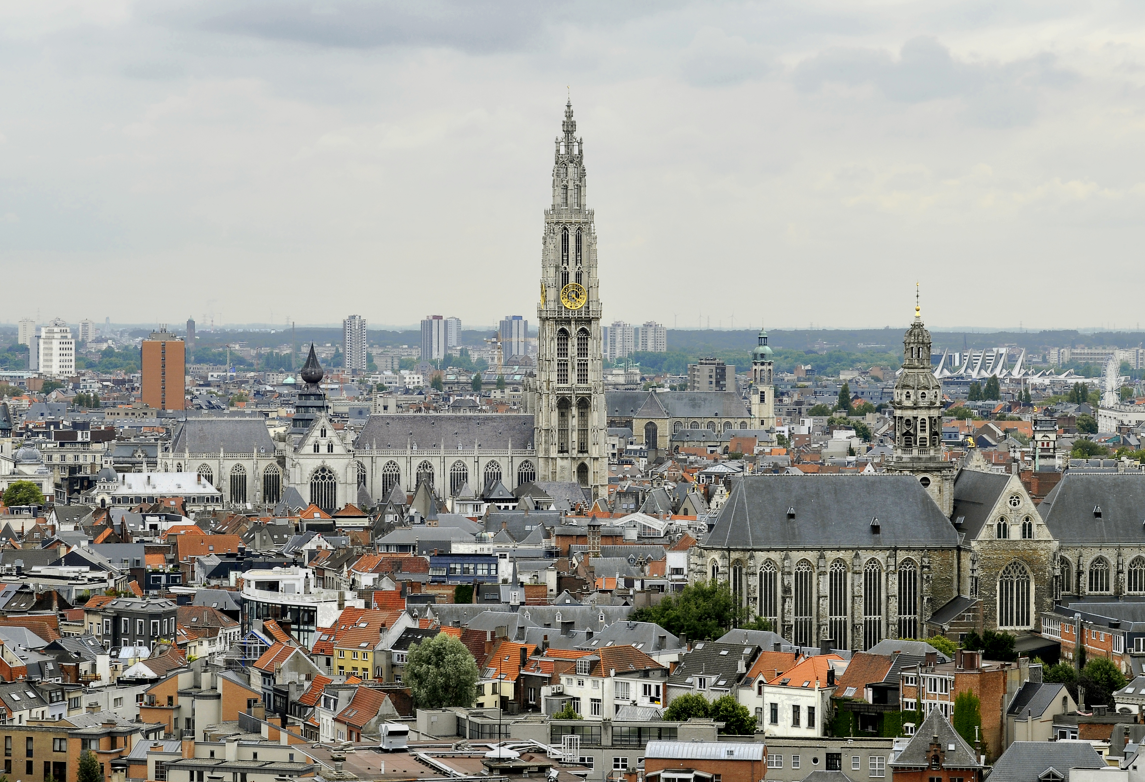
Antwerp (; nl, Antwerpen ; french: Anvers ; es, Amberes) is the largest city in Belgium by area at and the capital of Antwerp Province in the Flemish Region. With a population of 520,504,Statistics Belgium; ''Loop van de bevolking per gemeente'' (Excel file) Population of all municipalities in Belgium, . Retrieved 1 November 2017. it is the most populous municipality in Belgium, and with a metropolitan population of around 1,200,000 people, it is the second-largest ... [...More Info...] [...Related Items...] OR: [Wikipedia] [Google] [Baidu] |
Ganshoren
Ganshoren (, ) is one of the List of municipalities of the Brussels-Capital Region, 19 municipalities of the Brussels-Capital Region, Belgium. Located in the north-western part of the region, it is bordered by Jette, Koekelberg, and Sint-Agatha-Berchem, as well as the Flanders, Flemish municipality of Asse. In common with all of Brussels' municipalities, it is legally Multilingualism, bilingual (French–Dutch). On 1 January 2006, the municipality had a total population of 20,970. The total area is which gives a population density of . In 2018, Pierre Kompany was elected mayor of Ganshoren. He is the first black mayor in Belgium, and the father of footballer Vincent Kompany. References Notes External links * Archives Municipality Ganshoren Ganshoren, Municipalities of the Brussels-Capital Region Populated places in Belgium {{Brussels-geo-stub ... [...More Info...] [...Related Items...] OR: [Wikipedia] [Google] [Baidu] |
Verviers
Verviers (; wa, Vervî) is a city and municipality of Wallonia located in the province of Liège, Belgium. The municipality consists of the following districts: Ensival, Heusy, Lambermont, Petit-Rechain, Stembert, and Verviers. It is also the center of an agglomeration that includes Dison and Pepinster, making it the second biggest in the province and an important regional center, located roughly halfway between Liège and the German border. Water has played an important role in the town's economy, notably in the development first of its textile and later its tourist industries. As a result, many fountains have been built in Verviers, leading it to be named Wallonia's "Water Capital". The seats of the two Walloon public institutions for water distribution and water treatment are located in the town. History Early history Various flint and bone fragments, as well as Roman coins, were found in this area, attesting to the early settlements in the region. In the 4th c ... [...More Info...] [...Related Items...] OR: [Wikipedia] [Google] [Baidu] |
Ouffet
Ouffet (; wa, Oufet) is a municipality of Wallonia located in the province of liège, Belgium. On January 1, 2006, Ouffet had a total population of 2,529. The total area is 40.22 km2 which gives a population density of 63 inhabitants per km2. The municipality consists of the following districts A district is a type of administrative division that, in some countries, is managed by the local government. Across the world, areas known as "districts" vary greatly in size, spanning regions or county, counties, several municipality, municipa ...: Ellemelle, Ouffet, and Warzée. See also * List of protected heritage sites in Ouffet References External links * Municipalities of Liège Province {{Liege-geo-stub ... [...More Info...] [...Related Items...] OR: [Wikipedia] [Google] [Baidu] |
Jalhay
Jalhay (; wa, Djalhé) is a municipality of Wallonia located in the province of Liège, Belgium. On 1 January 2006 Jalhay had a total population of 7,953. The total area is 107.75 km² which gives a population density of 74 inhabitants per km². The municipality consists of the following districts: Jalhay and Sart. The highest point of the municipality is the Baraque Michel in the High Fens The High Fens (german: Hohes Venn; french: Hautes Fagnes; nl, Hoge Venen), which were declared a nature reserve in 1957, are an upland area, a plateau region in Liège Province, in the east of Belgium and adjoining parts of Germany, between the ..., at . See also * List of protected heritage sites in Jalhay References External links * Municipalities of Liège Province {{Liege-geo-stub ... [...More Info...] [...Related Items...] OR: [Wikipedia] [Google] [Baidu] |
Hainaut (province)
Hainaut (, also , , ; nl, Henegouwen ; wa, Hinnot; pcd, Hénau), historically also known as Heynowes in English, is a province of Wallonia and Belgium. To its south lies the French department of Nord, while within Belgium it borders (clockwise from the North) on the Flemish provinces of West Flanders, East Flanders, Flemish Brabant and the Walloon provinces of Walloon Brabant and Namur. Its capital is Mons (Dutch ''Bergen'') and the most populous city is Charleroi, the province's urban, economic and cultural hub, the financial capital of Hainaut and the fifth largest city in the country by population. Hainaut has an area of and as of January 2019 a population of 1,344,241. Another remarkable city is Tournai (Dutch ''Doornik'') on the Scheldt river, one of the oldest cities of Belgium and the first capital of the Frankish Empire. Hainaut province exists of a wavy landscape, except for the very southern part, the so-called ''Boot of Hainaut'', which is quite hilly and belon ... [...More Info...] [...Related Items...] OR: [Wikipedia] [Google] [Baidu] |
Péronnes-lez-Binche
Péronnes-lez-Binche ( wa, Perone) is town of Wallonia and a district of the municipality of Binche located in the province of Hainaut, Belgium. It was a municipality before the 1977 fusion of the Belgian municipalities. Péronnes became known for its coal rich ground which allowed the mining industry to grow. The mining industry has now been dead for decades but ancient coal hills and few infrastructure stays to remind of the golden age. The most well known building is Triage-Lavoir, coal washing plant, which was built in 1954 with the help of Marshall Plan The Marshall Plan (officially the European Recovery Program, ERP) was an American initiative enacted in 1948 to provide foreign aid to Western Europe. The United States transferred over $13 billion (equivalent of about $ in ) in economic re .... External links * Former municipalities of Hainaut (province) Binche {{Hainaut-geo-stub ... [...More Info...] [...Related Items...] OR: [Wikipedia] [Google] [Baidu] |
Mouscron
Mouscron (; Dutch and vls, Moeskroen, ; Picard and Walloon: ''Moucron'') is a city and municipality of Wallonia located in the Belgian province of Hainaut, along the border with the French city of Tourcoing, which is part of the Lille metropolitan area. The municipality consists of the following districts: Dottignies, Herseaux, Luingne, and Mouscron. In accordance with the national law, the municipality offers facilities for the Dutch speaking minority. Kortrijk, in Flanders, is located just to the north of Mouscron. The city substantially grew during the 19th and early 20th century with the development of the textile industry in the north of France. The symbol of the city is the Hurlu: a character representing Protestant activists, who plundered the countryside during the Wars of Religion (16th century). Geography Mouscron is divided into 7 districts: the downtown (le centre), the train station (la gare), Mont-à-Leux, Tuquet, Risquons-Tout, Nouveau-Monde and Coqui ... [...More Info...] [...Related Items...] OR: [Wikipedia] [Google] [Baidu] |
Overijse
Overijse () is a municipality in the province of Flemish Brabant, in Flanders, Belgium. It is a suburb of the wider Brussels metropolitan area. The municipality comprises the town of Overijse, and the communities of Eizer, Maleizen, Jezus-Eik, Tombeek and Terlanen. On December 31, 2008, Overijse had a total population of 24,410. The total area is 44.43 km² which gives a population density of 549 inhabitants per km². Overijse is surrounded by an extensive woodlands (Zoniënwoud/Forêt de Soignes), with paths for walking and cycling. The official language is Dutch. French-speaking residents who have migrated mainly from Wallonia or Brussels are represented by 8 members on the 27-seat local council. According to the 2008 census, Overijse was also home to 4,842 expatriates including 1,236 Dutch, 766 British, 505 Germans, 375 Americans, 311 French and 295 Italian. Near Overijse there is a medium wave transmitter for the Belgian foreign radio service. Overijse has a traditi ... [...More Info...] [...Related Items...] OR: [Wikipedia] [Google] [Baidu] |
De Pinte
De Pinte () is a municipality located in the Belgian province of East Flanders. Before its existence as an independent municipality in 1868, De Pinte was a part of Nazareth. The municipality comprises the towns of De Pinte proper and Zevergem. In 2021, De Pinte had a total population of 10,990. The total area is 17.78 km². History The name of the municipality is issued from an inn, which was called "Het Pijntken", which was situated in the actual Pintestraat 69, and which was firstly used as the name of the municipality when it became independent of Nazareth on 2. June 1868 and it was called 'Little Nazareth" at that time. At the end of the 19th century many horticultural companies came in this area and further on in the 20th century, they were all parceled out. De Pinte became also a train station between Ghent and Kortrijk (as from 1839) and Ghent-Oudenaarde (as from 1857). The territory remained a vast stretch of moorland of the Abbey of Ghent Saint-Peter, which was cal ... [...More Info...] [...Related Items...] OR: [Wikipedia] [Google] [Baidu] |
Erpe-Mere
Erpe-Mere () is a municipality located in the Belgian province of East Flanders in the Denderstreek. The municipality comprises the towns of Aaigem, Bambrugge, Burst, Erondegem, Erpe, Mere, Ottergem and Vlekkem. There is also a hamlet in Bambrugge: Egem. Erpe-Mere is crossed by 2 brooks, the Molenbeek and the Molenbeek-Ter Erpenbeek. In 2022 Erpe-Mere had a total population of 20,127. The total area is 34.03 km². The current mayor of Erpe-Mere is Hugo De Waele, from the CD&V (Christian Democratic) party. History The municipality was formed in 1975 by the merger of the eight sub-municipalities of today, but the sub-communities Erpe and Mere initially disagreed on the new name for the merged municipality. While Erpe had the largest area, Mere was central in the entire area and had more inhabitants. As a compromise they choose the double name Erpe-Mere. Geography The municipality is bordered to the north by Lede, in the east by Aalst and Haaltert, in the south by He ... [...More Info...] [...Related Items...] OR: [Wikipedia] [Google] [Baidu] |
Zottegem
Zottegem (, Sotteghem and Sottegem in older English and French language sources) is a municipality located in Belgium and more particularly in Flanders, in the province of East Flanders. The municipality comprises the town of Zottegem proper and the villages of Elene, Erwetegem, Godveerdegem, Grotenberge, Leeuwergem, Oombergen, Sint-Goriks-Oudenhove, Sint-Maria-Oudenhove, Strijpen and Velzeke-Ruddershove. On 1 January 2018, Zottegem had a total population of 26,373. The total area is 56.66 km2 which gives a population density of 470 inhabitants per km2. Zottegem is part of the hilly geographical area of the Flemish Ardennes (''Vlaamse Ardennen''); the hills and cobblestone streets ( Paddestraat) are regular locations in the springtime cycle classics of Flanders. The city is known for its ties with Lamoral, Count of Egmont; Lamoral has a castle (''Egmontkasteel''), a museum (''Egmontkamer'') and two statues in the centre of Zottegem. He is buried in a crypt (''Egm ... [...More Info...] [...Related Items...] OR: [Wikipedia] [Google] [Baidu] |


