|
Minamidaitōjima
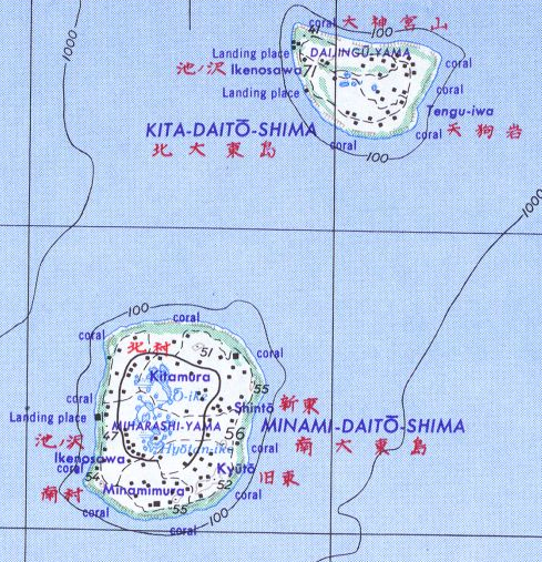
, also spelt as Minami Daitō or Minami-Daitō, is the largest island in the Daitō Islands group southeast of Okinawa, Japan. It is administered as part of the village of Minamidaitō, Okinawa. Shimajiri District, Okinawa and has a population of 2,107. The island is entirely cultivated for agriculture. The island has no beaches but has a fishing boat harbor and three cargo and ferry ports; as well as an airport Minami Daito Airport (airport code "MMD"). Geography Minamidaitōjima is a relatively isolated coralline island, located approximately south of Kitadaitōjima, the second largest island of the archipelago, and from Naha, Okinawa. As with the other islands in the archipelago, Minamidaitōjima is an uplifted coral atoll with a steep coastal cliff of limestone (the former fringing coral reef of the island), and a depressed center (the former lagoon of the island). The island is roughly oval in shape, with a circumference of about , length of and an area of . The ... [...More Info...] [...Related Items...] OR: [Wikipedia] [Google] [Baidu] |
Daitō Islands
The are an archipelago consisting of three isolated coral islands, administered by Japan, in the Philippine Sea southeast of Okinawa Prefecture, Okinawa. The islands have a total area of and a population of 2,107. Administratively, the whole group belongs to Shimajiri District, Okinawa, Shimajiri District of Okinawa Prefecture, and is divided between the villages of Minamidaitō, Okinawa, Minamidaitō and Kitadaitō, Okinawa, Kitadaitō, with uninhabited Okidaitōjima island administered as part of Kitadaitō municipality, although physically located closer to Minamidaitōjima. Etymology ''Kita'', ''minami'', and ''oki'' means, respectively, "north", "south", and "offshore" while ''daitō'' means "great east". History These islands have long been known in Okinawa as ''Ufuagari'' (“the Great East”). Okidaitōjima was first sighted by the Spanish Empire, Spanish Spanish explorers, explorer Bernardo de la Torre on 25 September 1543 during a failed attempt to find a northern r ... [...More Info...] [...Related Items...] OR: [Wikipedia] [Google] [Baidu] |
Kitadaitōjima
, also spelled as Kita Daitō, Kita-Daitō-shima, and Kitadaitō, is the northernmost island in the Daitō Islands group, located in the Philippine Sea southeast of Okinawa, Japan. It is administered as part of the village of Kitadaitō, Shimajiri District, Okinawa. The island is entirely cultivated for agriculture. The island has no beaches but has a fishing harbor, three ferry docks and an airport (Kitadaito Airport) (airport code "KTD") for local flights. Geography Kitadaitōjima is a relatively isolated coralline island, located approximately north of Minamidaitōjima, the largest island of the archipelago, and from Naha, Okinawa. As with the other islands in the archipelago, Kitadaitōjima is an uplifted coral atoll with a steep coastal cliff of limestone (the former fringing coral reef of the island), and a depressed center (the former lagoon of the island). The island is roughly oval in shape, with a circumference of about , length of and an area of . The highest poi ... [...More Info...] [...Related Items...] OR: [Wikipedia] [Google] [Baidu] |
Minamidaitō, Okinawa
is a List of villages in Japan, village located entirely on Minamidaitōjima in Shimajiri District, Okinawa, Shimajiri District, Okinawa Prefecture, Japan. Minamidaitōjima is located approximately east of Okinawa Island. Minamidaitō covers . As of June 2013, the city had a population of 1,418 and a population density of 46.4 people per km2. Geography The island is in the subtropical zone and was formed out of coral reef. With the exception of neighboring Kitadaitō, there is no inhabited land within 400 km of Minamidaitō. Administrative divisions The village includes six wards. *Ikenosawa (池之沢) *Kita (北) *Kyūtō (旧東) *Minami (南) *Shintō (新東) *Zaisho (在所) Climate Minamidaitō has a tropical rainforest climate (Köppen climate classification ''Af'') with very warm summers and mild winters. Precipitation is significant throughout the year; the wettest month is June and the driest month is February. The island is subject to frequent typhoons. H ... [...More Info...] [...Related Items...] OR: [Wikipedia] [Google] [Baidu] |
Ōike
is a karst pond on Minamidaitōjima, Okinawa Prefecture, Japan. Ōike is the largest pond containing both freshwater and seawater. It covers , the circumference is , and it is at its deepest point. Fresh water is mixed with seawater beneath. Geology The island is composed of elevated limestone from its atoll. Rainwater has dissolved the limestone leading to a depression in the ground (sinkhole). This has filled with water to become a pond. Natural history On the north of the pond extends an area of wetland with large communities of Bruguera gymnorrhiza, a mangrove plant, which was designated as a Natural monument since it is unique in freshwater on March 18, 1975. Other plants include ''Scirpus tabemaemontani C. C. Gemlin, Panicum repens L. Najas marina'' and ''Vallisneria natans''. Common carp and ''Carassius auratus langsdorfii'' were introduced in 1910 and tilapia in 1955. Birds include mallard, Pacific reef heron, common moorhen and cattle egret.Environmental Agency''T ... [...More Info...] [...Related Items...] OR: [Wikipedia] [Google] [Baidu] |
Okinawa Prefecture
is the southernmost and westernmost prefecture of Japan. It consists of three main island groups—the Okinawa Islands, the Sakishima Islands, and the Daitō Islands—spread across a maritime zone approximately 1,000 kilometers east to west and 400 kilometers north to south. Despite a modest land area of 2,281 km² (880 sq mi), Okinawa’s territorial extent over surrounding seas makes its total area nearly half the combined size of Honshu, Shikoku, and Kyushu. Of its 160 Island, islands, 49 are inhabited. The largest and most populous island is Okinawa Island, which hosts the capital city, Naha, as well as major urban centers such as Okinawa (city), Okinawa, Uruma, and Urasoe, Okinawa, Urasoe. The prefecture has a subtropical climate, characterized by warm temperatures and high rainfall throughout the year. People from the Ryukyu Islands, Nansei Islands, including Okinawa Island, Okinawa, the Sakishima Islands, and parts of Kagoshima Prefecture, are often collectively referred ... [...More Info...] [...Related Items...] OR: [Wikipedia] [Google] [Baidu] |
Empire Of Japan
The Empire of Japan, also known as the Japanese Empire or Imperial Japan, was the Japanese nation state that existed from the Meiji Restoration on January 3, 1868, until the Constitution of Japan took effect on May 3, 1947. From Japan–Korea Treaty of 1910, 1910 to Japanese Instrument of Surrender, 1945, it included the Japanese archipelago, the Kuril Islands, Kurils, Karafuto Prefecture, Karafuto, Korea under Japanese rule, Korea, and Taiwan under Japanese rule, Taiwan. The South Seas Mandate and Foreign concessions in China#List of concessions, concessions such as the Kwantung Leased Territory were ''de jure'' not internal parts of the empire but dependent territories. In the closing stages of World War II, with Japan defeated alongside the rest of the Axis powers, the Japanese Instrument of Surrender, formalized surrender was issued on September 2, 1945, in compliance with the Potsdam Declaration of the Allies of World War II, Allies, and the empire's territory subsequent ... [...More Info...] [...Related Items...] OR: [Wikipedia] [Google] [Baidu] |
Typhoon
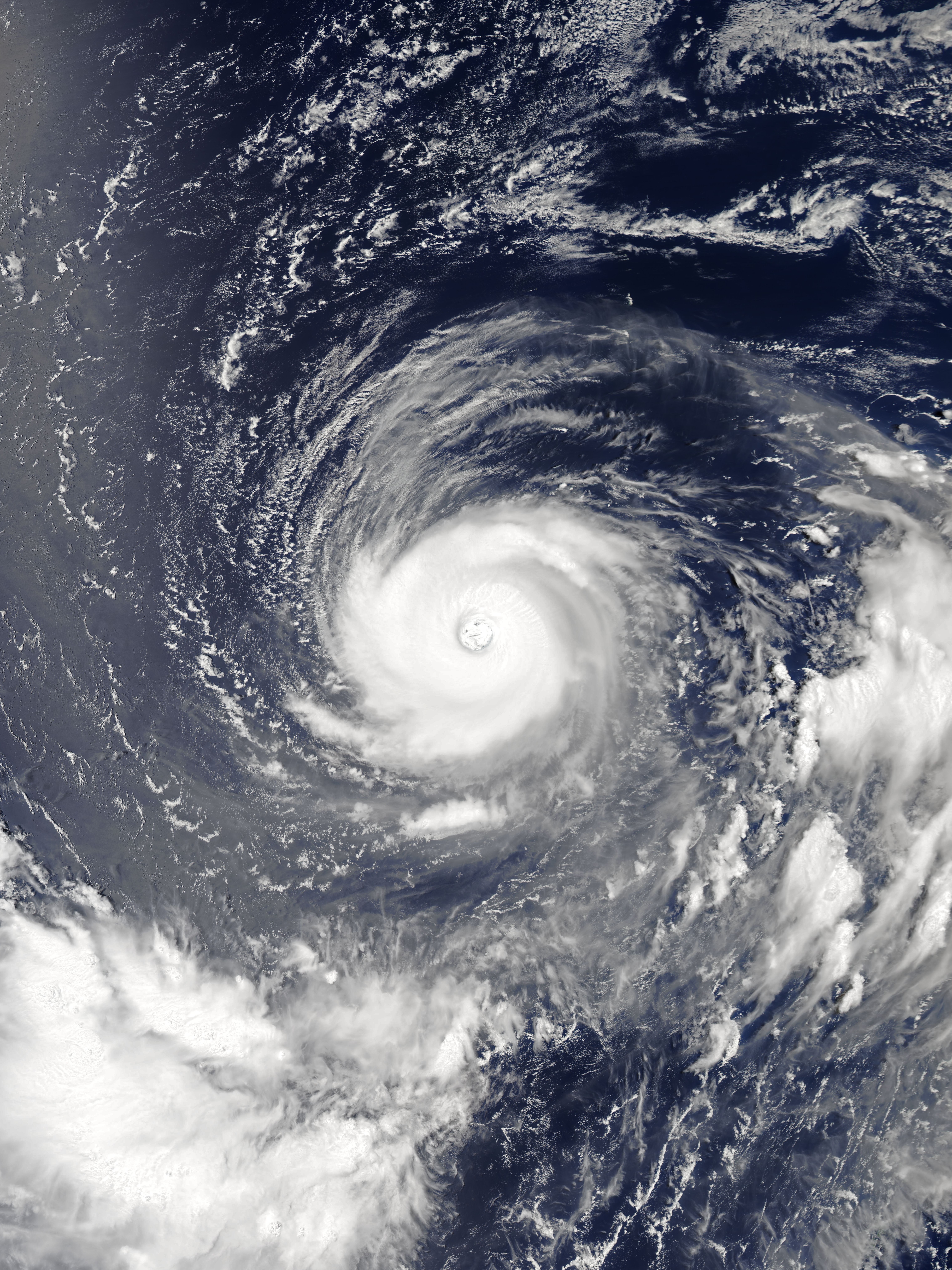
A typhoon is a tropical cyclone that develops between 180° and 100°E in the Northern Hemisphere and which produces sustained hurricane-force winds of at least . This region is referred to as the Northwestern Pacific Basin, accounting for almost one third of the world's tropical cyclones. For organizational purposes, the northern Pacific Ocean is divided into three regions: the eastern (North America to 140°W), central (140°W to 180°), and western (180° to 100°E). The Regional Specialized Meteorological Center (RSMC) for tropical cyclone forecasts is in Japan, with other tropical cyclone warning centres for the northwest Pacific in Hawaii (the Joint Typhoon Warning Center), the Philippines, and Hong Kong. Although the RSMC names each system, the main name list itself is coordinated among 18 countries that have territories threatened by typhoons each year. Within most of the northwestern Pacific, there are no official typhoon seasons as tropical cyclones form througho ... [...More Info...] [...Related Items...] OR: [Wikipedia] [Google] [Baidu] |
Bernardo De La Torre
Bernardo de la Torre or della Torres (died 1545) was a Spanish explorer during the Age of Discovery. He participated in Ruy López de Villalobos's failed expedition to establish a greater Spanish presence in the East Indies. Stuck for months on the eastern side of Mindanao, the expedition ran low on supplies, suffered repeated accidents, and was discovered and ordered to leave by the Portuguese. López de Villalobos sent De la Torre east across the Pacific Ocean to seek supplies and reinforcements from Mexico. Attempting a new northern route, De la Torre discovered the Volcano Islandswhich he named after an eruption active as he passedbefore being forced to turn back from lack of water and high storm waves. During this return voyage, his ship became the first known to have circumnavigated Mindanao. De la Torre is sometimes further claimed to have named Mindanao Caesarea Caroli in honor of the Habsburg emperor CharlesV; to have named Leyte and Samar the Philippines in honor of t ... [...More Info...] [...Related Items...] OR: [Wikipedia] [Google] [Baidu] |
New Spain
New Spain, officially the Viceroyalty of New Spain ( ; Nahuatl: ''Yankwik Kaxtillan Birreiyotl''), originally the Kingdom of New Spain, was an integral territorial entity of the Spanish Empire, established by Habsburg Spain. It was one of several domains established during the Spanish colonization of the Americas, Spanish conquest of the Americas, and had its capital in Mexico City. Its jurisdiction comprised a large area of the southern and western portions of North America, mainly what became Mexico and the Southwestern United States, but also California, Florida and Louisiana (New Spain), Louisiana; Central America as Mexico, the Caribbean like Hispaniola and Martinique, Martinica, and northern parts of South America, even Colombia; several Pacific archipelagos, including the Philippines and Guam. Additional Asian colonies included "Spanish Formosa", on the island of Taiwan. After the 1521 Spanish conquest of the Aztec Empire, conqueror Hernán Cortés named the territory New S ... [...More Info...] [...Related Items...] OR: [Wikipedia] [Google] [Baidu] |
Philippine Sea
The Philippine Sea is a List of seas#Marginal seas by ocean, marginal sea of the Pacific Ocean, Western Pacific Ocean east of the list of islands of the Philippines, Philippine Archipelago (hence the name) and the List of seas#Largest seas by area, largest sea in the world, occupying an estimated surface area of . The Philippine Sea Plate forms the floor of the sea. Its western border is the first island chain to the west, comprising the Ryukyu Islands in the northwest and Taiwan in the west. Its southwestern border comprises the Philippines, Philippine islands of Luzon, Catanduanes, Samar, Leyte, and Mindanao. Its northern border comprises the Japanese islands of Honshu, Shikoku and Kyūshū. Its eastern border is the second island chain to the east, comprising the Bonin Islands and Iwo Jima in the northeast, the Mariana Islands (including Guam, Saipan, and Tinian) in the due east, and Halmahera, Palau, Yap and Ulithi (of the Caroline Islands) in the southeast. Its southern ... [...More Info...] [...Related Items...] OR: [Wikipedia] [Google] [Baidu] |
Köppen Climate Classification
The Köppen climate classification divides Earth climates into five main climate groups, with each group being divided based on patterns of seasonal precipitation and temperature. The five main groups are ''A'' (tropical), ''B'' (arid), ''C'' (temperate), ''D'' (continental), and ''E'' (polar). Each group and subgroup is represented by a letter. All climates are assigned a main group (the first letter). All climates except for those in the ''E'' group are assigned a seasonal precipitation subgroup (the second letter). For example, ''Af'' indicates a tropical rainforest climate. The system assigns a temperature subgroup for all groups other than those in the ''A'' group, indicated by the third letter for climates in ''B'', ''C'', ''D'', and the second letter for climates in ''E''. Other examples include: ''Cfb'' indicating an oceanic climate with warm summers as indicated by the ending ''b.'', while ''Dwb'' indicates a semi-Monsoon continental climate, monsoonal continental climate ... [...More Info...] [...Related Items...] OR: [Wikipedia] [Google] [Baidu] |


