|
Milngavie
Milngavie ( ; ) is a town in East Dunbartonshire, Scotland and a suburb of Glasgow. It is on the Allander Water, at the northwestern edge of Greater Glasgow, and about from Glasgow city centre. It neighbours Bearsden. Milngavie is a commuter town, with much of its working population travelling to Glasgow to work or study. The town is served by Milngavie railway station on the North Clyde Line of the SPT rail network, which links it to Central Glasgow. In 2018, the Scottish Government published statistics for the town showing that the population increased to 13,537 in 6,062 households. The town is also a popular retirement location, with a high number of elderly people living there. The ''Milngavie and Bearsden Herald'', owned by Johnston Press, is a weekly newspaper that covers local events from the schools, town halls, community and government in the area. The paper was established in 1901 and is printed every Wednesday, to be sold on Thursdays. The town is the start poi ... [...More Info...] [...Related Items...] OR: [Wikipedia] [Google] [Baidu] |
Bearsden
Bearsden ( ) is a town in East Dunbartonshire, Scotland, on the northwestern fringe of Greater Glasgow, approximately from the Glasgow city centre, city centre. The Roman Empire, Roman Antonine Wall runs through the town, and the remains of a military thermae, bath house can be seen near the town centre. The current settlement began in the 17th century as the kirkton of the parish of New Kilpatrick, and when a railway connection to Glasgow was constructed in 1863, it developed into an affluent suburb of the city. By 2020, it had an estimated population of 28,470. History Roman The first known settlement on the site of present-day Bearsden was a Roman Empire, Roman fort in the second century Anno Domini, AD. Between 142 and 144 AD, under Roman Emperor, Emperor Antoninus Pius, the Romans built a stone and turf fortification, called the Antonine Wall, between the Firth of Clyde and the Firth of Forth. They also built the Military Way, a road that ran parallel, to the sout ... [...More Info...] [...Related Items...] OR: [Wikipedia] [Google] [Baidu] |
Clydebank And Milngavie (Scottish Parliament Constituency)
Clydebank and Milngavie (Gaelic: ''Bruach Chluaidh agus Muileann-Ghaidh'') is a constituency of the Scottish Parliament covering part of the council areas of East Dunbartonshire and West Dunbartonshire. It elects one Member of the Scottish Parliament (MSP) by the first past the post method of election. It is also one of ten constituencies in the West Scotland electoral region, which elects seven additional members, in addition to the ten constituency MSPs, to produce a form of proportional representation for the region as a whole. The current member is Marie McNair of the Scottish National Party (SNP), who has held the seat since the 2021 Scottish Parliament election. Electoral region The other nine constituencies of the West Scotland region are: Cunninghame North, Cunninghame South, Dumbarton, Eastwood, Greenock and Inverclyde, Paisley, Renfrewshire North and West, the Renfrewshire South and Strathkelvin and Bearsden. The region covers part of the Argyll and ... [...More Info...] [...Related Items...] OR: [Wikipedia] [Google] [Baidu] |
Milngavie Railway Station
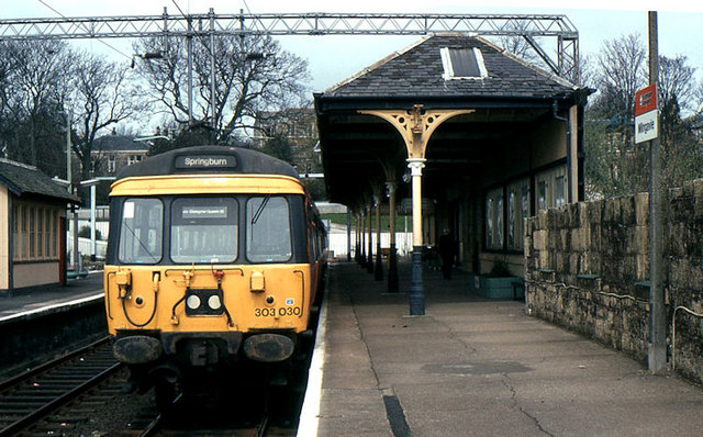
Milngavie railway station serves the town of Milngavie, East Dunbartonshire, near Glasgow in Scotland. The station is sited from Glasgow Queen Street, measured via Maryhill. The station is managed by ScotRail, who also operate all services at the station, along the North Clyde and Argyle lines. Its principal purpose today is as a commuter station for people working in Glasgow city centre. The station itself is a category B listed building. History The station was opened in April 1863, and was then part of the Glasgow and Milngavie Junction Railway. Originally built with three platforms, one platform has since been removed. The land where the third platform once stood has been sold. The line was doubled in 1900, but was singled again in 1990. During December 2020, the long platforms were extended to by reinstating of unused platform and adding a further of new platform. The project cost £5 million. Location The station is the usual access point for the long W ... [...More Info...] [...Related Items...] OR: [Wikipedia] [Google] [Baidu] |
West Highland Way
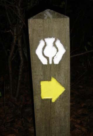
The West Highland Way () is a linear Long-distance trail, long-distance route in Scotland. It is long, running from Milngavie north of Glasgow to Fort William, Highland, Fort William in the Scottish Highlands, with an element of hill walking in the route. The trail, which opened in 1980, was Scotland's first officially designated Long Distance Route, and is now designated by NatureScot as one of Scotland's Great Trails. It is primarily intended as a long distance hiking, walking route, and whilst many sections are suitable for mountain biking and horseriding there are obstacles and surfaces that will require these users to dismount in places. It is managed by the West Highland Way Management Group (WHWMG) consisting of the local government in Scotland, local authorities for East Dunbartonshire, Stirling (council area), Stirling, Argyll and Bute and Highland (council area), Highland, alongside the Loch Lomond and The Trossachs National Park, Loch Lomond and The Trossachs Nationa ... [...More Info...] [...Related Items...] OR: [Wikipedia] [Google] [Baidu] |
East Dunbartonshire
East Dunbartonshire (; , ) is one of the 32 council areas of Scotland. It borders Glasgow City Council Area to the south, North Lanarkshire to the east, Stirling (council area), Stirling to the north, and West Dunbartonshire to the west. East Dunbartonshire contains many of the suburbs in the north of Greater Glasgow, including Bearsden, Milngavie, Bishopbriggs, Kirkintilloch, Lenzie, Twechar, Milton of Campsie, Balmore, and Torrance, East Dunbartonshire, Torrance, as well as some other of Glasgow's commuter towns and villages. The council area covers parts of the Historic counties of Scotland, historic counties of Dunbartonshire, Lanarkshire, and Stirlingshire. The council area was formed in 1996, as a result of the Local Government etc. (Scotland) Act 1994, from the former Bearsden and Milngavie districts and most of the former Strathkelvin Local government areas of Scotland 1973 to 1996, district, which had been part of the Strathclyde region. History East Dunbartonshire wa ... [...More Info...] [...Related Items...] OR: [Wikipedia] [Google] [Baidu] |
North Clyde Line
The North Clyde Line (defined by Network Rail as the ''Glasgow North Electric Suburban'' line) is a suburban railway in West Central Scotland. The route is operated by ScotRail. As a result of the incorporation of the Airdrie–Bathgate rail link and the Edinburgh–Bathgate line, this route has become the fourth rail link between Glasgow and Edinburgh. Route The North Clyde Line (known as Dunbartonshire - Glasgow, Cumbernauld and Falkirk Grahamston in timetables), electrified by British Rail in 1960, ran east–west through the Greater Glasgow conurbation, linking northern Lanarkshire with western Dunbartonshire, by way of the city centre. Fifty years later, in 2010, the line was extended by Network Rail east from Airdrie, by way of re-opening the line to Bathgate meeting up with the line re-opened by British Rail from Edinburgh. The main core of the route runs from to via and Glasgow Queen Street (Low Level). To the east of the Glasgow city centre, there is a sho ... [...More Info...] [...Related Items...] OR: [Wikipedia] [Google] [Baidu] |
Glasgow
Glasgow is the Cities of Scotland, most populous city in Scotland, located on the banks of the River Clyde in Strathclyde, west central Scotland. It is the List of cities in the United Kingdom, third-most-populous city in the United Kingdom and the 27th-most-populous city in Europe, and comprises Wards of Glasgow, 23 wards which represent the areas of the city within Glasgow City Council. Glasgow is a leading city in Scotland for finance, shopping, industry, culture and fashion, and was commonly referred to as the "second city of the British Empire" for much of the Victorian era, Victorian and Edwardian eras. In , it had an estimated population as a defined locality of . More than 1,000,000 people live in the Greater Glasgow contiguous urban area, while the wider Glasgow City Region is home to more than 1,800,000 people (its defined functional urban area total was almost the same in 2020), around a third of Scotland's population. The city has a population density of 3,562 p ... [...More Info...] [...Related Items...] OR: [Wikipedia] [Google] [Baidu] |
Strathclyde Region
Strathclyde ( in Welsh language, Welsh; in Scottish Gaelic, Gaelic, meaning 'strath [valley] of the River Clyde') was one of nine former Local government in Scotland, local government Regions and districts of Scotland, regions of Scotland created in 1975 by the Local Government (Scotland) Act 1973 and abolished in 1996 by the Local Government etc (Scotland) Act 1994, Local Government etc. (Scotland) Act 1994. The Strathclyde region had 19 Regions and districts of Scotland, districts. The region was named after the early medieval Kingdom of Strathclyde centred on Govan, but covered a broader geographic area than its namesake. History The Strathclyde region was created in 1975 under the Local Government (Scotland) Act 1973, which established a two-tier structure of local government across Scotland comprising upper-tier regions and lower-tier districts. Strathclyde covered the whole area of six shires of Scotland, counties and parts of another two, which were all abolished for lo ... [...More Info...] [...Related Items...] OR: [Wikipedia] [Google] [Baidu] |
Glasgow Corporation Tramways
Glasgow Corporation Tramways were formerly one of the largest urban tramway systems in Europe. Over 1,000 municipally owned trams served the city of Glasgow, Scotland, with over 100 route miles (160 route kilometres) by 1922. The system closed in 1962 and was the last city tramway in Great Britain (prior to the construction of new systems in the 1990s). Creation The ( 33 & 34 Vict. c. clxxv) was enacted by Parliament in August 1870. This legislation allowed Glasgow Town Council to decide whether or not to have tramways within Glasgow. In 1872, the Town Council laid a route from St George's Cross to Eglinton Toll (via New City Road, Cambridge Street, Sauchiehall Street, Renfield Street and the Jamaica Bridge).Glasgow Trams through the Years, Part 1 Glasgow History, 12 October 2019< ... [...More Info...] [...Related Items...] OR: [Wikipedia] [Google] [Baidu] |
New Kilpatrick
New Kilpatrick, (also known as East Kilpatrick or Easter Kilpatrick) is an ecclesiastical Parish and former Civil Parish in Dunbartonshire. It was formed in 1649 from the eastern half of the parish of Kilpatrick (also known as Kirkpatrick), the western half forming Old Kilpatrick. New Kilpatrick is also a disused name for the town of Bearsden. Originally spanning a large area from Strathblane in the North to Baldernock and Summerston (on the River Kelvin) in the East, down to Anniesland in the South and Yoker and Duntocher in the West, a quarter of the parish was once in the county of Stirlingshire. The geography of the area has supported mining, iron-working and quarrying in the past, but these are no longer economically viable, and much of the area functions as suburbs of Glasgow. Local government of the area was once the responsibility of the kirk, but is now administered by East Dunbartonshire, Glasgow and Stirlingshire councils. The name New Kilpatrick was dropped from gene ... [...More Info...] [...Related Items...] OR: [Wikipedia] [Google] [Baidu] |
Mid Dunbartonshire (UK Parliament Constituency)
Mid Dunbartonshire is a constituency of the House of Commons in the UK Parliament. Further to the completion of the 2023 review of Westminster constituencies, it was first contested at the 2024 general election, when it was won by Susan Murray of the Liberal Democrats. Boundaries The constituency comprises the following wards of the East Dunbartonshire council area: * In full: Milngavie, Bearsden North, Bearsden South, Bishopbriggs North and Campsie, Bishopbriggs South. * In part: Lenzie and Kirkintilloch South (virtually all the electorate), Kirkintilloch East and North and Twechar (small part comprising the northern areas of the town of Kirkintilloch). It covers virtually all of the former East Dunbartonshire constituency, together with a small part of the Cumbernauld, Kilsyth and Kirkintilloch East constituency (renamed Cumbernauld and Kirkintilloch), including Lennoxtown and Milton of Campsie. Constituency profile Electoral Calculus characterises the seat as "Str ... [...More Info...] [...Related Items...] OR: [Wikipedia] [Google] [Baidu] |
Allander Water
The Allander Water () is a river in East Dunbartonshire and Stirling, Scotland, and one of the three main tributaries of the River Kelvin, the others being the Glazert Water and the Luggie Water. It flows through Milngavie. See also *List of places in East Dunbartonshire ''Map of places in East Dunbartonshire compiled from this list'':See the list of places in Scotland for places in other counties. This List of places in East Dunbartonshire is a list of links for any town, village and hamlet (place), hamlet in th ... * List of places in Stirling External linksRCAHMS record of Craigmaddie, Allander Water, Valve chamber [...More Info...] [...Related Items...] OR: [Wikipedia] [Google] [Baidu] |


