|
Mesen
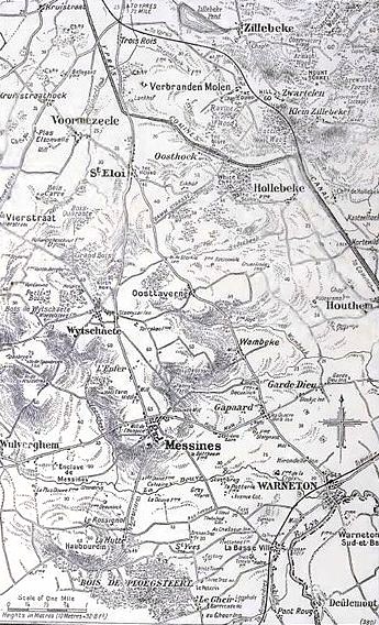
Mesen (; french: Messines, , historically used in English) is a city and municipality located in the Belgian province of West Flanders. On January 1, 2006, Mesen had a total population of 988. The total area is 3.58 km2 which gives a population density of 276 inhabitants per km2. The municipality comprises only one main settlement, the town of Mesen proper. An exclave to the west of the main territory is surrounded by the municipalities of Heuvelland and Comines-Warneton. Villages neighbouring the municipality: * a. Wijtschate (in the municipality of Heuvelland) * b. Warneton (in the municipality of Comines-Warneton) * c. Ploegsteert (in the municipality of Comines-Warneton) Mesen is the smallest city in Belgium. It is a municipality with language facilities. Mesen is twinned with Featherston in New Zealand in part due to the location of the New Zealand World War I Memorial, which has annual Anzac Day commemorations on 25 April. History In 1062, Adela, wi ... [...More Info...] [...Related Items...] OR: [Wikipedia] [Google] [Baidu] |
Messines Ridge (New Zealand) Memorial
The Messines Ridge (New Zealand) Memorial is a World War I memorial, located in Messines Ridge British Cemetery, near the town of Mesen, Belgium. The memorial lists 827 officers and men of the New Zealand Expeditionary Force with no known grave who died in or near Messines in 1917 and 1918.Messines Ridge (New Zealand) Memorial Commonwealth War Graves Commission, retrieved 22 February 2011 This period included the Battle of Messines. History The memorial, designed by the English architect , is one of seven such memorials on the[...More Info...] [...Related Items...] OR: [Wikipedia] [Google] [Baidu] |
Battle Of Messines (1917)
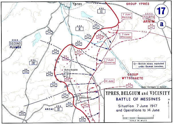
The Battle of Messines (7–14 June 1917) was an attack by the British Second Army (General Sir Herbert Plumer), on the Western Front, near the village of Messines (now Mesen) in West Flanders, Belgium, during the First World War. The Nivelle Offensive in April and May had failed to achieve its more grandiose aims, had led to the demoralisation of French troops and confounded the Anglo-French strategy for 1917. The attack forced the Germans to move reserves to Flanders from the Arras and Aisne fronts, relieving pressure on the French. The British tactical objective was to capture the German defences on the ridge, which ran from Ploegsteert Wood (Plugstreet to the British) in the south, through Messines and Wytschaete to Mt Sorrel, depriving the German 4th Army of the high ground. The ridge gave commanding views of the British defences and back areas of Ypres to the north, from which the British intended to conduct the Northern Operation, an advance to Passchendaele Ridge an ... [...More Info...] [...Related Items...] OR: [Wikipedia] [Google] [Baidu] |
Mines In The Battle Of Messines (1917)
At the start of the Battle of Messines during the First World War, underground explosive charges were detonated by the British Second Army (General Sir Herbert Plumer) beneath the forward position of the German 4th Army near the village of Mesen (''Messines'' in French, historically used in English), in Belgian West Flanders. The mines, secretly planted by British tunnelling units, created craters and killed approximately 10,000 German soldiers. Their joint explosion ranks among the largest non-nuclear explosions of all time. The evening before the attack, General Sir Charles Harington, Chief of Staff of the Second Army, remarked to the press, "Gentlemen, I don’t know whether we are going to make history tomorrow, but at any rate we shall change geography". The Battle of Messines marked the zenith of mine warfare. On 10 August, the Royal Engineers fired the last British deep mine of the war, at Givenchy-en-Gohelle near Arras. Background British mining, 1915–1916 ... [...More Info...] [...Related Items...] OR: [Wikipedia] [Google] [Baidu] |
Heuvelland
Heuvelland () is a municipality located in the Belgian province of West Flanders. The municipality comprises the villages of Dranouter, Kemmel, De Klijte, Loker, Nieuwkerke, Westouter, Wijtschate and Wulvergem. Heuvelland is a thinly populated rural municipality, located between the small urban centres of Ypres and Poperinge and the metropolitan area of Kortrijk-Lille along the E17. On 1 January 2006 Heuvelland had a total population of 8,217. The total area is 94.24 km2 which gives a population density of 87 inhabitants per km2. The name ''heuvelland'' is Dutch meaning "hill country", as the municipality is characterized by the different hills on its territory. Geography Landscape The municipality is located in an area known as the West-Flemish Hills. The highest hill in Heuvelland is the Kemmelberg (156 m); followed by the Vidaigneberg (136 m), the Rodeberg (129 m), the Scherpenberg (125 m) and a lower hill in Wijtschate (82 m). On the border with France is the ... [...More Info...] [...Related Items...] OR: [Wikipedia] [Google] [Baidu] |
Wijtschate
Heuvelland () is a municipality located in the Belgian province of West Flanders. The municipality comprises the villages of Dranouter, Kemmel, De Klijte, Loker, Nieuwkerke, Westouter, Wijtschate and Wulvergem. Heuvelland is a thinly populated rural municipality, located between the small urban centres of Ypres and Poperinge and the metropolitan area of Kortrijk-Lille along the E17. On 1 January 2006 Heuvelland had a total population of 8,217. The total area is 94.24 km2 which gives a population density of 87 inhabitants per km2. The name ''heuvelland'' is Dutch meaning "hill country", as the municipality is characterized by the different hills on its territory. Geography Landscape The municipality is located in an area known as the West-Flemish Hills. The highest hill in Heuvelland is the Kemmelberg (156 m); followed by the Vidaigneberg (136 m), the Rodeberg (129 m), the Scherpenberg (125 m) and a lower hill in Wijtschate (82 m). On the border with France is th ... [...More Info...] [...Related Items...] OR: [Wikipedia] [Google] [Baidu] |
Municipality With Language Facilities
There are 27 municipalities with language facilities ( nl, faciliteitengemeenten; french: communes à facilités; german: Fazilitäten-Gemeinden) in Belgium which must offer linguistic services to residents in Dutch, French, or German in addition to their single official languages. All other municipalities – with the exception of those in the bilingual Brussels region – are unilingual and only offer services in their official languages, either Dutch or French. Belgian law stipulates that: *12 municipalities in Flanders must offer services in French; of these 12, six ( located around Brussels) are now believed to have become majority French-speaking. *Wallonia contains two language areas: **In the French-speaking part of Wallonia, four municipalities offer services in Dutch and another two offer services in German. **All municipalities in the German-speaking part of Wallonia ( annexed after WWI) offer services in French. *In Brussels, Dutch and French are co-official. *At t ... [...More Info...] [...Related Items...] OR: [Wikipedia] [Google] [Baidu] |
Irish Peace Park
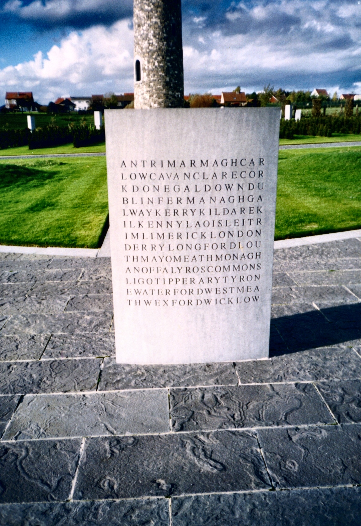
The Island of Ireland Peace Park and its surrounding park ( ga, Páirc Síochána d'Oileán na hÉireann), also called the Irish Peace Park or Irish Peace Tower in Messines, near Ypres in Flanders, Belgium, is a war memorial to the soldiers of the island of Ireland who died, were wounded or are missing from World War I, during Ireland's involvement in the conflict. The tower memorial is close to the site of the June 1917 battle of Messines Ridge, during which the 16th (Irish) Division fought alongside the 36th (Ulster) Division. Development Because of the events of the Easter Rebellion in 1916 and the partition of Ireland under the Anglo-Irish Treaty in 1922 and the Irish Civil War that followed it, little was done in the Republic of Ireland to commemorate the Irish dead from the Great War or World War II. Those countries who were engaged in the Great War all preserve the memory of their fallen soldiers with national monuments in the Western Front area. This led to some ill- ... [...More Info...] [...Related Items...] OR: [Wikipedia] [Google] [Baidu] |
Battle Of Messines (1914)
The Battle of Messines was fought in October 1914 between the armies of the German empire and British empire and France as part of the Race to the Sea, between the river Douve and the Comines–Ypres canal. Background Strategic developments From the belligerents had made reciprocal attempts to turn the northern flank of their opponent. Joseph Joffre, the head of (Chief of the General Staff) ordered the French Second Army to move to the north of the 6th Army, by transferring by rail from eastern France from Erich von Falkenhayn, Chief of (the German General Staff) ordered the German 6th Army to move from the German–French border to the northern flank on 17 September. By the next day French attacks north of the Aisne, led to Falkenhayn ordering the 6th Army to repulse French forces to secure the flank. On 24 September, the French advance met a German attack rather than an open flank and by 29 September, having been reinforced to eight corps, the Second Army was still bein ... [...More Info...] [...Related Items...] OR: [Wikipedia] [Google] [Baidu] |
Arrondissement Of Ypres
The Arrondissement of Ypres ( nl, Arrondissement Ieper; french: Arrondissement d'Ypres) is one of the eight administrative arrondissements in the Province of West Flanders, Belgium Belgium, ; french: Belgique ; german: Belgien officially the Kingdom of Belgium, is a country in Northwestern Europe. The country is bordered by the Netherlands to the north, Germany to the east, Luxembourg to the southeast, France to .... It is both an administrative and a judicial arrondissement. However, the Judicial Arrondissement of Ypres also comprises the municipalities of Staden and Moorslede in the Arrondissement of Roeselare. Municipalities The Administrative Arrondissement of Ypres consists of the following municipalities: * Heuvelland * Langemark-Poelkapelle * Mesen * Poperinge * Vleteren * Wervik * Ypres * Zonnebeke Ypres {{WestFlanders-geo-stub ... [...More Info...] [...Related Items...] OR: [Wikipedia] [Google] [Baidu] |
Battle Of The Lys (1918)
The Battle of the Lys, also known as the Fourth Battle of Ypres, was fought from 7 to 29 April 1918 and was part of the German spring offensive in Flanders during the First World War. It was originally planned by General Erich Ludendorff as Operation George but was reduced to Operation Georgette, with the objective of capturing Ypres, forcing the British forces back to the Channel ports and out of the war. In planning, execution and effects, Georgette was similar to (although smaller than) Operation Michael, earlier in the Spring Offensive. Background Strategic developments The German attack zone was in Flanders, from about east of Ypres in Belgium to east of Béthune in France, about south. The front line ran from north-north-east to south-south-west. The Lys River, running from south-west to north-east, crossed the front near Armentières in the middle of this zone. The front was held by the Belgian Army in the far north, by the British Second Army (under Plumer) ... [...More Info...] [...Related Items...] OR: [Wikipedia] [Google] [Baidu] |
Saint Sidronius
Saint Sidronius (died ) was a Roman martyr. His life is confused with a French saint of the same name. His feast date is 8 September or 11 July. Church The village of Saint-Cydroine in the commune of Laroche-Saint-Cydroine near Sens in Yonne, France, is named after the saint. It is said that Sidronius was martyred here by the Romans, and a spring here with miraculous powers was a place of pilgrimage in the Middle Ages. The Saint Cydroine Church is an 11th- or 12th-century Romanesque church with an octagonal tower in the village dedicated to the saint. It was founded by the abbey of La Charité-sur-Loire. Monks of Ramsgate account The monks of St Augustine's Abbey, Ramsgate, wrote in their ''Book of Saints'' (1921), Baring-Gould's account Sabine Baring-Gould (1834–1924) wrote in his ''Lives of the Saints'' (1897), Butler's account The hagiographer Alban Butler Alban Butler (13 October 171015 May 1773) was an English Roman Catholic priest and hagiographer. Biography ... [...More Info...] [...Related Items...] OR: [Wikipedia] [Google] [Baidu] |
Featherston, New Zealand
Featherston (Māori: ''Paetūmōkai'') is a town in the South Wairarapa District, in the Wellington Region of New Zealand's North Island. It is at the eastern foothills of Remutaka Range close to the northern shore of Lake Wairarapa, north-east of central Wellington and south-west of Masterton. The town has a population of Featherston has increasingly become a satellite town of Wellington since the Remutaka rail tunnel opened in 1955; at the 2006 census, 36% of employed Featherston residents worked in Wellington and the Hutt Valley. This proximity to the capital, coupled with low house prices, made Featherston popular with writers, artists and those with young families, in turn leading to a recent upsurge in business investment and creative activity. From 2014 to 2019, housing prices in Featherston increased by 108% while rental prices went from an average of $140 to $400 in the same time period. History Wairarapa Moana (Lake Wairarapa) was among the first areas settled in ... [...More Info...] [...Related Items...] OR: [Wikipedia] [Google] [Baidu] |


.jpg)