|
Mercantour
Mercantour National Park (french: Parc national du Mercantour) a French national park located in the Alpes-de-Haute-Provence and Alpes-Maritimes departments. Since it was created in 1979, the park has proven popular, with 800,000 visitors annually enjoying the 600 km (372 mi) of marked footpaths and visiting its villages. Extent The protected area covers some 679 km2, consisting of a central uninhabited zone comprising seven valleys: Roya, Bévéra, Vésubie, Tinée, Haut Var and Cians (in Alpes-Maritimes) plus Verdon and Ubaye (in Alpes-de-Haute-Provence), as well as a peripheral zone comprising 28 villages. Many of them are perched villages, such as Belvédère at the entrance to the spectacular Gordolasque valley, concealing great architectural riches (numerous churches decorated with murals and altar pieces by primitive Niçois painters). More than 150 rural sites are located within the Park. Around Mont Bégo there are petroglyphs pecked out on s ... [...More Info...] [...Related Items...] OR: [Wikipedia] [Google] [Baidu] |
Maritime Alps
The Maritime Alps (french: Alpes Maritimes ; it, Alpi Marittime ) are a mountain range in the southwestern part of the Alps. They form the border between the regions of France, French region of Provence-Alpes-Côte d'Azur and the regions of Italy, Italian regions of Piedmont and Liguria. They are the southernmost part of the Alps. Geography Administratively the range is divided between the Provinces of Italy, Italian provinces of Province of Cuneo, Cuneo and Province of Imperia, Imperia (eastern slopes) and the Departments of France, French department of Alpes-Maritimes (western slopes). The Maritime Alps are drained by the rivers Roya (river), Roya, Var River, Var and Verdon River, Verdon and their tributaries on the French side; by the Stura di Demonte and other tributaries of the Tanaro River, Tanaro and Po River, Po on the Italian side. There are many attractive perched villages, such as Belvédère at the entrance to the spectacular Gordolasque valley, some concealing unex ... [...More Info...] [...Related Items...] OR: [Wikipedia] [Google] [Baidu] |
Alpes-Maritimes
Alpes-Maritimes (; oc, Aups Maritims; it, Alpi Marittime, "Maritime Alps") is a Departments of France, department of France located in the country's southeast corner, on the France–Italy border, Italian border and Mediterranean Sea, Mediterranean coast. Part of the Provence-Alpes-Côte d'Azur Regions of France, region, it encompasses the French Riviera alongside neighbouring Var (department), Var. Alpes-Maritimes had a population of 1,094,283 in 2019.Populations légales 2019: 06 Alpes-Maritimes INSEE Its Prefectures in France, prefecture (and largest city) is Nice, with Grasse as the sole Subprefectures in France, subprefecture. Alpes-Maritimes has become one of the world's most attractive tourist destinations in recent years, featuring renowned cities and towns such as Nice, Gras ... [...More Info...] [...Related Items...] OR: [Wikipedia] [Google] [Baidu] |
Lac D'Allos
Lac d'Allos is an alpine lake at a height of 2,230 m. It is located in Parc National du Mercantour, departement Alpes-de-Haute-Provence the region Provence-Alpes-Côte d'Azur, France. Description Lac d'Allos is a lake in the Alpes-de-Haute-Provence and is dominated by Mont Pelat (3052 meters), it is the largest natural high altitude lake in Europe Europe is a large peninsula conventionally considered a continent in its own right because of its great physical size and the weight of its history and traditions. Europe is also considered a subcontinent of Eurasia and it is located enti .... It covers 60 hectares and has a depth of 50 m. In the twelfth century, it was called Levedone. The lake is situated nearby the municipality of Allos. Gallery File:Lac_d'Allos.JPG, Side of the lake, August 2015 File:Lac d'Allos4.JPG, Another side of the lake File:Lac_d'Allos3.jpg, Another side of the lake, August 2015 File:Lac_d'AllosFlowers.JPG, Flowers on the side of the lake Se ... [...More Info...] [...Related Items...] OR: [Wikipedia] [Google] [Baidu] |
Cime Du Gélas
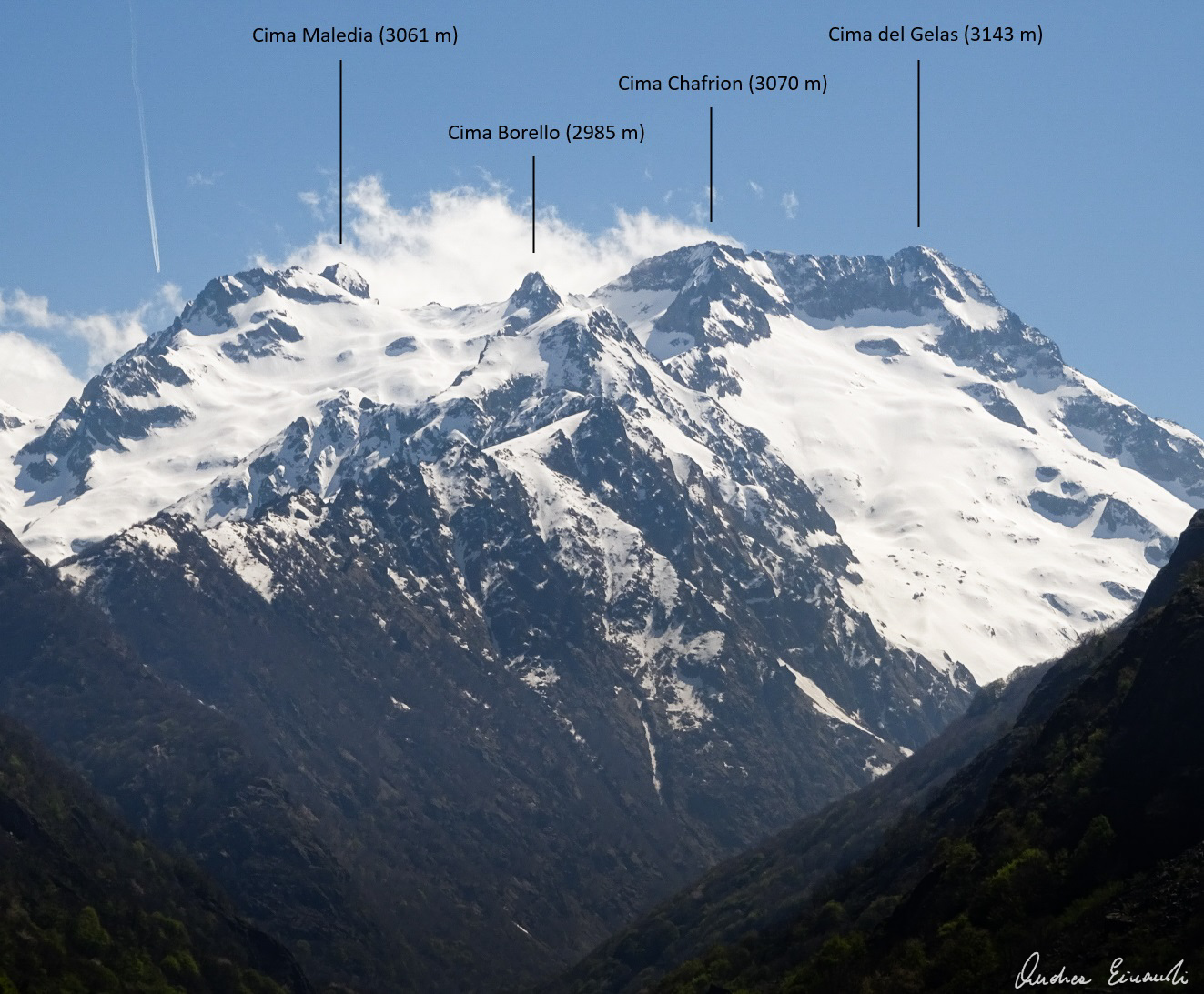
Cime du Gélas (Italian: ''Monte Gelàs'') is a 3,143 m high mountain on the boundary between France (Provence-Alpes-Côte d'Azur region) and Italy (province of Cuneo). It is part of the Maritime Alps. It is the highest peak of the Mercantour National Park, while on the Italian side it is included in the Maritime Alps Natural Park. Geologically, it is part of the Mercantour-Argentera massif, and is mostly formed by granitoid gneiss. The peak is composed of two smaller ones, divided by a gorge; the highest peak is the northern one, which is topped by a cross built here by priests from Cuneo. The mountain's name derives from the glaciers which occupy its northern slopes, which have however reduced substantially during the late 20th century. References Maps * Italian official cartography (''Istituto Geografico Militare'' - IGM); on-line versionwww.pcn.minambiente.it* French official cartography (''Institut Géographique National An institute is an organisational body ... [...More Info...] [...Related Items...] OR: [Wikipedia] [Google] [Baidu] |
Mont Bégo
Mont Bégo ( it, Monte Bego; lij, Monte Begu) is a mountain in the Mercantour massif of the Maritime Alps, in southern France, with an elevation of . It is included in the Vallée des Merveilles ("Valley of Marvels"). Etymology The name derives from the ancient Indo-European root ''beg'', meaning "divine"; it was, in fact a sacred area to the Liguri tribe, together with the Monte Beigua and Monte Sagro in Italy. Geology It is mostly composed of conglomerates from the Permian period. SOIUSA classification According to the SOIUSA (''International Standardized Mountain Subdivision of the Alps'') the mountain can be classified in the following way: * main part = Western Alps * major sector = South Western Alps * section = Maritime Alps The Maritime Alps (french: Alpes Maritimes ; it, Alpi Marittime ) are a mountain range in the southwestern part of the Alps. They form the border between the regions of France, French region of Provence-Alpes-Côte d'Azur and the regio ... [...More Info...] [...Related Items...] OR: [Wikipedia] [Google] [Baidu] |
Belvédère
Belvédère (; oc, Barver; it, Belvedere) is a commune in the Vésubie valley north of Nice in the Alpes-Maritimes department in southeastern France. The village of Belvédère is located at the entrance of the Gordolasque valley on the edge of the Mercantour National Park. Over its history the Commune of Belvédère has been part of the Kingdom of Burgundy, the Kingdom of Sardinia, the First French Empire, the Duchy of Savoy and since 1860 modern France. The last battle on French soil in the Second World War, the Battle of Authion, was fought on the hills above the village. The world famous novel ''Darkness at Noon'' was completed in a villa nearby and the television series ''Belle and Sebastian'' was shot in and around the village. History The Bronze Age Belvédère lies immediately to the west of Mont Bégo, known as the sacred mountain in Mercantour National Park. For thousands of years, from the Stone Age till the Iron Age, the first inhabitants of Europe carved ... [...More Info...] [...Related Items...] OR: [Wikipedia] [Google] [Baidu] |
Lakes Of Vens
The lakes of Vens ( French: ''Lacs de Vens'') are located in the massif of the Mercantour, between the elevations of and , in the township of Saint-Étienne-de-Tinée, in the department of the Alpes-Maritimes. Geography The lakes of Vens consist of a succession of five main lakes. The largest, overlooked by the refuge of Vens, has a depth of . Itinerary The lakes of Vens are accessible to the hikers from the hamlet of the Pra on the route of the col de la Bonette Col de la Bonette (el. ) is a high mountain pass in the French Alps, near the border with Italy. It is situated within the Mercantour National Park on the border of the departments of Alpes-Maritimes and Alpes-de-Haute-Provence. The road over the ... or from Saint-Étienne-de-Tinée. References {{Reflist Vens Vens ... [...More Info...] [...Related Items...] OR: [Wikipedia] [Google] [Baidu] |
Gordolasque
The Gordolasque is a mountain river that flows from the Mercantour National Park in the Alpes-Maritimes department of southeastern France. It is long. Its source is in the Maritime Alps, near the Italian border. It flows into the river Vésubie below the perched village of Belvédère Belvédère (; oc, Barver; it, Belvedere) is a commune in the Vésubie valley north of Nice in the Alpes-Maritimes department in southeastern France. The village of Belvédère is located at the entrance of the Gordolasque valley on the edg .... References External links * http://www.lagordolasque.com La Gordolasque , Photographs Mountain , Alpes-Maritimes France Mercantour National Park Rivers of France Rivers of Alpes-Maritimes Rivers of Provence-Alpes-Côte d'Azur {{France-river-stub ... [...More Info...] [...Related Items...] OR: [Wikipedia] [Google] [Baidu] |
List Of National Parks Of France
The national parks of France are a system of eleven national parks throughout metropolitan France and its overseas departments, coordinated by National Parks of France ( French: ''Parcs nationaux de France'') within the French Office for Biodiversity (''Office français pour la biodiversité''), an établissement public à caractère administratif guided by the Ministry of Ecological Transition and Ministry of Agriculture and Food. The first national park was established in 1963; the most recent park was established in 2019. National parks are created by decree with the signature of the Prime Minister of France and publication in the ''Journal Officiel de la République Française''. French national parks protect a total area of in core area and in buffer zones. This puts over 9.5% of French territory under the protection of national parks; 29.5% of French lands and 22% of French waters are covered by some level of protection. French national parks draw over 8.5 million visi ... [...More Info...] [...Related Items...] OR: [Wikipedia] [Google] [Baidu] |
Ubaye
The Ubaye (; oc, Ubaia) is a river of southeastern France. It is long and flows through the Alpes-de-Haute-Provence department. Its drainage basin is .Bassin versant : Ubaye (L') Observatoire Régional Eau et Milieux Aquatiques en PACA Its rises at the Col de Longet, in the on the border with . It flows generally southwest, through Saint-Paul-sur-Ubaye, |
Lakes Of Morgon
The lakes of Morgon ( French: ''Lacs de Morgon'') are a group of lakes in the Tinée valley, Alpes-Maritimes, Alps, France. The first lake is the Big Lake of Morgon at an elevation of 2427 m. The other major lakes are the Median Lake (2470 m) and the Higher Lake (2480 m). Of note, three other lakes can be found in the vicinity of the Morgon lakes: the lakes Les Laussets. Itinerary On the way of the Col de la Bonette from the Tinée side, stop at the Camp des Fourches, and go to the Col des Fourches. Follow the GR 5 The GR 5 is a GR footpathThe acronym GR stands for "Grande Randonnée" (in French), meaning "Great Hike". that starts in the Netherlands, crosses Belgium and Luxembourg before crossing France from north to south. It is part of the European wal ... to go down in the ravin de Cougnas. Leave the GR at tag 37 (2100 m), and follow on the right the small footpath and the cairns along the Salso Moreno torrent. Enter a small rocky gorge on the right, and reach the Big ... [...More Info...] [...Related Items...] OR: [Wikipedia] [Google] [Baidu] |
Roya (river)
The Roya (French, ), Roia ( Italian), or Ròia ( Brigasc, Occitan) is a river of France and Italy, discharging into the Ligurian Sea. It is long, of which in France. Its drainage basin is about , of which in France.Bassin versant : Roya (La) Observatoire Régional Eau et Milieux Aquatiques en PACA 
River course The river rises in French territory near the Col de Tende and flows through the Mercantour ...[...More Info...] [...Related Items...] OR: [Wikipedia] [Google] [Baidu] |
.jpg)


