|
Menstrie Glen
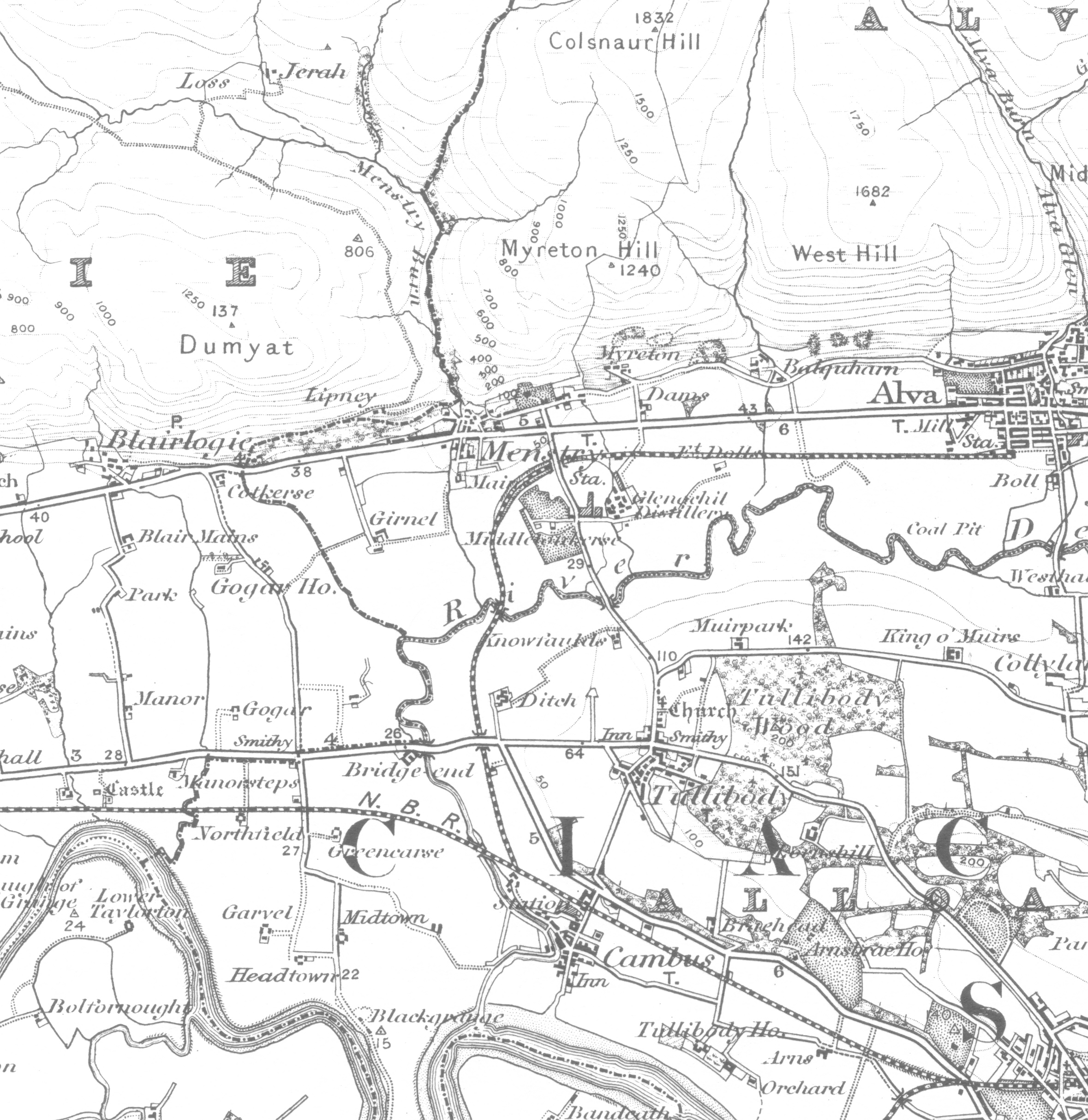
Menstrie Glen is the glen which separates Dumyat from Myreton Hill and the main body of the Ochil Hills in Scotland. Once farmed but no longer inhabited, it is now used for sheep pasture, a public water supply and recreation in the form of fishing and walking. A plan is under consideration (autumn 2014) for commercial forestry on the eastern and northern flanks of the glen. Vegetation and topography Much of the area of the glen is rough pasture where sheep graze. Bracken is also abundant while broad-leaved trees grow in the deeply cut burnsides and in the vicinity of abandoned settlements. The bed of the glen ranges in altitude from 228m, at the saddle at UK Grid reference NN819002, to about 20m where it emerges onto the flood plain in Menstrie at NS849970. Near its upper (west) end, the glen contains the Lossburn Reservoir which holds drinking water and is used for recreational fishing. The reservoir accepts water from the north-western slopes of Dumyat and from the south-wes ... [...More Info...] [...Related Items...] OR: [Wikipedia] [Google] [Baidu] |
Menstrie Glen, Upper, Looking West
Menstrie (Scottish Gaelic: ) is a village in the county of Clackmannanshire in Scotland. It is about east-northeast of Stirling and is one of a string of towns that, because of their location at the foothill base of the Ochil Hills, are collectively referred to as the Hillfoots Villages or simply ''The Hillfoots''. Etymology The name ''Menstrie'', recorded as ''Mestreth'' and ''Mestryn'' in the 1260s, is of Pictish language, Pictish origin. The name is composed of elements cognate to Welsh language, Welsh , meaning 'field, plain', and , 'town, village, farm'. Physical geography Menstrie stands on the carse or flood plain of the River Devon, Clackmannanshire, River Devon, between 10 and 20 metres altitude above sea level. It is roughly astride the Ochil Fault whose movement gave rise to the dramatic southern scarp of the Ochils but which is now almost quiescent. Two of the most westerly summits of the Ochil Hills, Dumyat and Myreton Hill, rise steeply to the north of the vil ... [...More Info...] [...Related Items...] OR: [Wikipedia] [Google] [Baidu] |
Crown Land
Crown land, also known as royal domain, is a territorial area belonging to the monarch, who personifies the Crown. It is the equivalent of an entailed estate and passes with the monarchy, being inseparable from it. Today, in Commonwealth realms, crown land is considered public land and is apart from the monarch's private estate. Australia In Australia, public lands without a specific tenure (e.g. National Park or State Forest) are referred to as Crown land or State Land, which is described as being held in the "right of the Crown" of either an individual State or the Commonwealth of Australia (as Australia is a federation, there is no single "Crown" as legal entity). Most Crown lands in Australia are held by the Crown in the right of a State. The only land held by the Commonwealth consists of land in the Northern Territory (surrendered by South Australia), the Australian Capital Territory, Jervis Bay Territory, and small areas acquired for airports, defence and other govern ... [...More Info...] [...Related Items...] OR: [Wikipedia] [Google] [Baidu] |
Valleys Of Clackmannanshire
A valley is an elongated low area often running between hills or mountains and typically containing a river or stream running from one end to the other. Most valleys are formed by erosion of the land surface by rivers or streams over a very long period. Some valleys are formed through erosion by glacial ice. These glaciers may remain present in valleys in high mountains or polar areas. At lower latitudes and altitudes, these glacially formed valleys may have been created or enlarged during ice ages but now are ice-free and occupied by streams or rivers. In desert areas, valleys may be entirely dry or carry a watercourse only rarely. In areas of limestone bedrock, dry valleys may also result from drainage now taking place underground rather than at the surface. Rift valleys arise principally from earth movements, rather than erosion. Many different types of valleys are described by geographers, using terms that may be global in use or else applied only locally. Format ... [...More Info...] [...Related Items...] OR: [Wikipedia] [Google] [Baidu] |
Glens Of Scotland
A glen is a valley, typically one that is long and bounded by gently sloped concave sides, unlike a ravine, which is deep and bounded by steep slopes. The word is Goidelic in origin: ''gleann'' in Irish and Scottish Gaelic, ''glion'' in Manx. The designation "glen" also occurs often in place names. Glens are appreciated by tourists for their tranquility and scenery. Etymology The word is Goidelic in origin: ''gleann'' in Irish and Scottish Gaelic, ''glion'' in Manx. In Manx, ''glan'' is also to be found meaning glen. It is cognate with Welsh ''glyn''. Whittow defines it as a "Scottish term for a deep valley in the Highlands" that is "narrower than a strath". Examples in Northern England, such as Glenridding, Westmorland, or Glendue, near Haltwhistle, Northumberland, are thought to derive from the aforementioned Cumbric cognate, or another Brythonic equivalent. This likely underlies some examples in Southern Scotland. As the name of a river, it is thought to derive f ... [...More Info...] [...Related Items...] OR: [Wikipedia] [Google] [Baidu] |
Forestry Commission
The Forestry Commission is a non-ministerial government department responsible for the management of publicly owned forests and the regulation of both public and private forestry in England. The Forestry Commission was previously also responsible for forestry in Wales and Scotland. However, on 1 April 2013, Forestry Commission Wales merged with other agencies to become Natural Resources Wales, whilst two new bodies (Forestry and Land Scotland and Scottish Forestry) were established in Scotland on 1 April 2019. The Forestry Commission was established in 1919 to expand Britain's forests and woodland, which had been severely depleted during the First World War. The Commission bought large amounts of agricultural land on behalf of the state, eventually becoming the largest manager of land in Britain. Today, the Forestry Commission is divided into three divisions: Forestry England, Forestry Commission and Forest Research. Over time the purpose of the Commission broadened to include ... [...More Info...] [...Related Items...] OR: [Wikipedia] [Google] [Baidu] |
Menstrie Glen From NS 850 947 Looking North
Menstrie (Scottish Gaelic: ) is a village in the county of Clackmannanshire in Scotland. It is about east-northeast of Stirling and is one of a string of towns that, because of their location at the foothill base of the Ochil Hills, are collectively referred to as the Hillfoots Villages or simply ''The Hillfoots''. Etymology The name ''Menstrie'', recorded as ''Mestreth'' and ''Mestryn'' in the 1260s, is of Pictish origin. The name is composed of elements cognate to Welsh , meaning 'field, plain', and , 'town, village, farm'. Physical geography Menstrie stands on the carse or flood plain of the River Devon, between 10 and 20 metres altitude above sea level. It is roughly astride the Ochil Fault whose movement gave rise to the dramatic southern scarp of the Ochils but which is now almost quiescent. Two of the most westerly summits of the Ochil Hills, Dumyat and Myreton Hill, rise steeply to the north of the village to reach about 400m altitude. These two hills are divided b ... [...More Info...] [...Related Items...] OR: [Wikipedia] [Google] [Baidu] |
Sheriffmuir
Sheriffmuir; Scots: Sherramuir; Scottish Gaelic: Sliabh an t-Siorraim, the site of the inconclusive 1715 Battle of Sheriffmuir (part of the Jacobite rising of 1715), lies on the slopes of the Ochil Hills in Scotland, just inside the Perthshire border in Scotland. ''Report prepared for Historic Scotland by the Battlefields Trust'' The "Sheriffmuir Inn", which overlooks the battle site, used to house Hercules the wrestling bear for which it is well known. Single-track roads from the site lead to Dunblane, Greenloaning, Stirling and the A9 near Blackford. A monument to the battle stands next to the Dunblane road a few hundred yards from the site. Part of the British comedy film ''Monty Python and the Holy Grail ''Monty Python and the Holy Grail'' is a 1975 British comedy film based on the Arthurian legend, written and performed by the Monty Python comedy group (Graham Chapman, John Cleese, Terry Gilliam, Eric Idle, Terry Jones, and Michael Palin) and ...'' was fi ... [...More Info...] [...Related Items...] OR: [Wikipedia] [Google] [Baidu] |
Culross
Culross (/ˈkurəs/) (Scottish Gaelic: ''Cuileann Ros'', 'holly point or promontory') is a village and former royal burgh, and parish, in Fife, Scotland. According to the 2006 estimate, the village has a population of 395. Originally, Culross served as a Port, port city on the Firth of Forth and is believed to have been founded by Saint Serf during the 6th century. The civil parish had a population of 4,348 in 2011.Census of Scotland 2011, Table KS101SC – Usually Resident Population, publ. by National Records of Scotland. Web site http://www.scotlandscensus.gov.uk/ retrieved March 2016. See "Standard Outputs", Table KS101SC, Area type: Civil Parish 1930 Founding legend A legend states that when the Brittonic princess (and future saint) Teneu, daughter of the king of Lothian, became pregnant before marriage, her family threw her from a cliff. She survived the fall unharmed, and was soon met by an unmanned boat. She knew she had no home to go to, so she got into the boat; it s ... [...More Info...] [...Related Items...] OR: [Wikipedia] [Google] [Baidu] |
Cistercians
The Cistercians (), officially the Order of Cistercians (, abbreviated as OCist or SOCist), are a Catholic religious order of monks and nuns that branched off from the Benedictines and follow the Rule of Saint Benedict, as well as the contributions of the highly influential Bernard of Clairvaux, known as the Latin Rule. They are also known as Bernardines, after Bernard of Clairvaux, Saint Bernard, or as White Monks, in reference to the colour of their cowl, as opposed to the black cowl worn by Benedictines. The term ''Cistercian'' derives from ''Cistercium,'' the Latin name for the locale of Cîteaux, near Dijon in eastern France. It was here that a group of Benedictine monks from the monastery of Molesme Abbey, Molesme founded Cîteaux Abbey in 1098. The first three abbots were Robert of Molesme, Alberic of Cîteaux and Stephen Harding. Bernard helped launch a new era when he entered the monastery in the early 1110s with 30 companions. By the end of the 12th century, the ord ... [...More Info...] [...Related Items...] OR: [Wikipedia] [Google] [Baidu] |
Clan Campbell
Clan Campbell ( ) is a Scottish Highlands, Highland Scottish clan, historically one of the largest and most powerful of the Highland clans. The Clan Campbell lands are in Argyll and within their lands lies Ben Cruachan. The chief of the clan became Earl of Argyll and later Duke of Argyll. History Origins In traditional genealogies of Clan Campbell, the clan's origins are in the ancient Britons (Celtic people), Britons of Strathclyde. The earliest Campbell in written record is Gilleasbaig of Menstrie, Gillespie, whose name is recorded in 1263. Early grants to Gillespie and his relations were almost all in east-central Scotland. The family's connection with Argyll came some generations earlier when a Campbell married the heiress of the O'Duines and she brought with her the Lordship of Loch Awe. Because of this, the early clan name was ''Clan O'Duine''. The name was later styled ''Clann Diarmaid'' based on a fancied connection to ''Diarmuid the Boar'', a great hero from early Ce ... [...More Info...] [...Related Items...] OR: [Wikipedia] [Google] [Baidu] |


