|
Medusa Fossae
The Medusae Fossae Formation is a large geological formation of probable volcanic origin on the planet Mars. It is named for the Medusa of Greek mythology. "Fossae" is Latin for "trenches". The formation is a collection of soft, easily eroded deposits that extends discontinuously for more than 5,000 km along the equator of Mars. Its roughly-shaped regions extend from just south of Olympus Mons to Apollinaris Patera, with a smaller additional region closer to Gale Crater. The total area of the formation is equal to 20% the size of the continental United States. It is divided into three subunits (members) that are all considered to be of Amazonian age, the youngest era in martian geological history. The formation straddles the highland - lowland boundary near the Tharsis and Elysium volcanic areas, and extends across five quadrangles: Amazonis, Tharsis, Memnonia, Elysium, and Aeolis. Origin and age The origin of the formation is unknown, but many theories have bee ... [...More Info...] [...Related Items...] OR: [Wikipedia] [Google] [Baidu] |
Thermal Emission Imaging System
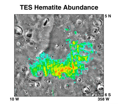
The Thermal Emission Imaging System (THEMIS) is a camera on board the 2001 Mars Odyssey orbiter. It images Mars in the visible and infrared parts of the electromagnetic spectrum in order to determine the thermal properties of the surface and to refine the distribution of minerals on the surface of Mars as determined by the Thermal Emission Spectrometer (TES). Additionally, it helps scientists to understand how the mineralogy of Mars relates to its landforms, and it can be used to search for thermal hotspots in the Martian subsurface. THEMIS is managed from the Mars Space Flight Facility at Arizona State University and was built by the Santa Barbara Remote Sensing division of Raytheon, Raytheon Technologies Corporation, an American multinational corporation, multinational list of conglomerates, conglomerate headquartered in Waltham, Massachusetts. The instrument is named after Themis, the goddess of justice in ancient Greek mythology. Infrared camera THEMIS detects thermal ... [...More Info...] [...Related Items...] OR: [Wikipedia] [Google] [Baidu] |
Apollinaris Mons
Apollinaris Mons is an ancient shield volcano in the southern hemisphere of Mars. It is situated near the equator, south of Elysium Planitia and north of the impact crater Gusev (the landing site of the Mars rover '' Spirit''). Elysium Planitia separates it from the volcanic province of Elysium to its northwest. The volcano's caldera is named Apollinaris Patera; this name formerly applied to the whole edifice. Apollinaris Mons is about 5 kilometres high with a base about 296 kilometres in diameter. On the top of this volcano is a caldera about 80 km (50 miles) in diameter. The volcano is approximately 3 billion to 3.5 billion years old. It was named in 1973 after a mountain spring near Rome in Italy. A study using a global climate model found that the Medusae Fossae Formation could have been formed from ash from Apollinaris Mons, Arsia Mons, and possibly Pavonis Mons.Kerber L., et al. 2012. The disporsal of pyroclasts from ancient explosive volcanoes on Mars: Implic ... [...More Info...] [...Related Items...] OR: [Wikipedia] [Google] [Baidu] |
Yardang
A yardang is a streamlined protuberance carved from bedrock or any consolidated or semiconsolidated material by the dual action of wind abrasion by dust and sand and deflation (the removal of loose material by wind turbulence). Yardangs become elongated features typically three or more times longer than wide, and when viewed from above, resemble the hull of a boat. Facing the wind is a steep, blunt face that gradually gets lower and narrower toward the lee end. Yardangs are formed by wind erosion, typically of an originally flat surface formed from areas of harder and softer material. The soft material is eroded and removed by the wind, and the harder material remains. The resulting pattern of yardangs is therefore a combination of the original rock distribution, and the fluid mechanics of the air flow and resulting pattern of erosion. Names The word itself is of Turkic origin, meaning ‘steep bank’, as this type of spectacular landscapes rising are best developed in th ... [...More Info...] [...Related Items...] OR: [Wikipedia] [Google] [Baidu] |
Martian Soil
Martian regolith is the fine blanket of unconsolidated, loose, heterogeneous superficial deposits covering the surface of Mars. The term ''Martian soil'' typically refers to the finer fraction of regolith. So far, no samples have been returned to Earth, the goal of a Mars sample-return mission, but the soil has been studied remotely with the use of Mars rovers and Mars orbiters. Its properties can differ significantly from those of terrestrial soil, including its toxicity due to the presence of perchlorates. Definitions On Earth, the term "soil" usually includes organic content. In contrast, planetary scientists adopt a functional definition of soil to distinguish it from rocks. ''Rocks'' generally refers to 10 cm scale and larger materials (e.g., fragments, breccia, and exposed outcrops) with high thermal inertia, with areal fractions consistent with the Viking Infrared Thermal Mapper (IRTM) data, and immobile under current aeolian (wind) conditions. Consequently, ''roc ... [...More Info...] [...Related Items...] OR: [Wikipedia] [Google] [Baidu] |
Inverted Relief
Inverted relief, inverted topography, or topographic inversion refers to landscape features that have reversed their elevation relative to other features. It most often occurs when low areas of a landscape become filled with lava or sediment that hardens into material that is more resistant to erosion than the material that surrounds it. ''Differential erosion'' then removes the less resistant surrounding material, leaving behind the younger resistant material, which may then appear as a ridge where previously there was a valley. Terms such as "inverted valley" or "inverted channel" are used to describe such features.Pain, C.F., and C.D. Ollier, 1995, ''Inversion of relief - a component of landscape evolution.'' Geomorphology. 12(2):151-165. Inverted relief has been observed on the surfaces of other planets as well as on Earth. For example, well-documented inverted topographies have been discovered on Mars.Pain, C.F., J.D.A. Clarke, and M. Thomas, 2007, ''Inversion of relief on ... [...More Info...] [...Related Items...] OR: [Wikipedia] [Google] [Baidu] |
Sinuous Ridges In Medusae Formation
Sinuosity, sinuosity index, or sinuosity coefficient of a continuously differentiable curve having at least one inflection point is the ratio of the curvilinear length (along the curve) and the Euclidean distance (straight line) between the end points of the curve. This dimensionless quantity can also be rephrased as the "actual path length" divided by the "shortest path length" of a curve. The value ranges from 1 (case of straight line) to infinity (case of a closed loop, where the shortest path length is zero for an infinitely-long actual path). Interpretation The curve must be continuous (no jump) between the two ends. The sinuosity value is really significant when the line is continuously differentiable (no angular point). The distance between both ends can also be evaluated by a plurality of segments according to a broken line passing through the successive inflection points (sinuosity of order 2). The calculation of the sinuosity is valid in a 3-dimensional space (e.g. ... [...More Info...] [...Related Items...] OR: [Wikipedia] [Google] [Baidu] |
Ignimbrite
Ignimbrite is a type of volcanic rock, consisting of hardened tuff. Ignimbrites form from the deposits of pyroclastic flows, which are a hot suspension of particles and gases flowing rapidly from a volcano, driven by being denser than the surrounding atmosphere. New Zealand geologist Patrick Marshall (1869–1950) coined the term ''ignimbrite'' from the Latin ''igni-'' [fire] and ''imbri-'' [rain]. Ignimbrites are made of a very poorly sorted mixture of volcanic ash (or tuff when Lithification, lithified) and pumice lapilli, commonly with scattered lithic fragments. The ash is composed of glass shards and crystal fragments. Ignimbrites may be loose and unconsolidated, or lithified (solidified) rock called lapilli tuff. Near the volcanic source, ignimbrites often contain thick accumulations of lithic blocks, and distally, many show meter-thick accumulations of rounded cobbles of pumice. Ignimbrites may be white, grey, pink, beige, brown, or black depending on their composition and ... [...More Info...] [...Related Items...] OR: [Wikipedia] [Google] [Baidu] |
Mars Orbiter Laser Altimeter
image:PIA02040 Martian hemispheres by MOLA.jpg, 260px, MOLA topographic images of the two hemispheres of Mars. This image appeared on the cover of ''Science'' magazine in May 1999. The Mars Orbiter Laser Altimeter (MOLA) was one of five instruments on the ''Mars Global Surveyor'' (MGS) spacecraft, which operated in Mars orbit from September 1997 to November 2006. However, the MOLA instrument transmitted altimetry data only until June 2001. The MOLA instrument transmitted infrared laser pulses towards Mars at a rate of 10 times per second and measured the time of flight to determine the range (distance) of the MGS spacecraft to the Martian surface. The range measurements resulted in precise topography, topographic maps of Mars. The precision maps are applicable to studies in geophysics, geology and atmospheric circulation. MOLA also functioned as a passive radiometer and measured the radiance of the surface of Mars at 1064 nanometers. Planetary laser altimetry A laser altimeter is ... [...More Info...] [...Related Items...] OR: [Wikipedia] [Google] [Baidu] |
MARSIS
MARSIS (Mars Advanced Radar for Subsurface and Ionosphere Sounding) is a low frequency, pulse-limited radar sounder and altimeter developed by the University of Rome La Sapienza and Alenia Spazio (today Thales Alenia Space Italy). The Italian MARSIS instrument, which is operated by the European Space Agency, is operational and orbits Mars as an instrument for the ESA's ''Mars Express'' exploration mission. The MARSIS Principal Investigator is Giovanni Picardi from the University of Rome "La Sapienza", Italy. It features ground-penetrating radar capabilities, which uses synthetic aperture technique and a secondary receiving antenna to isolate subsurface reflections. MARSIS identified buried basins on Mars. MARSIS was funded by ASI (Italy) and NASA (USA). The processor runs the real-time operating system EONIC Virtuoso. Deployment On May 4, 2005, ''Mars Express'' deployed the first of its two 20-metre-long radar booms for the MARSIS experiment. At first the boom didn't lock f ... [...More Info...] [...Related Items...] OR: [Wikipedia] [Google] [Baidu] |
Mars Express
''Mars Express'' is a space exploration mission by the European Space Agency, European Space Agency (ESA) exploring the planet Mars and its moons since 2003, and the first planetary mission attempted by ESA. ''Mars Express'' consisted of two parts, the ''Mars Express Orbiter'' and ''Beagle 2'', a Lander (spacecraft), lander designed to perform exobiology and geochemistry research. Although the lander failed to fully deploy after it landed on the Martian surface, the orbiter has been successfully performing scientific measurements since early 2004, namely, image resolution, high-resolution imaging and mineralogical mapping of the surface, radar sounding of the subsurface structure down to the permafrost, precise determination of the atmospheric circulation and composition, and study of the interaction of the Atmosphere of Mars, atmosphere with the interplanetary medium. Due to the valuable science return and the highly flexible mission profile, ''Mars Express'' has been granted ... [...More Info...] [...Related Items...] OR: [Wikipedia] [Google] [Baidu] |
Obliquity
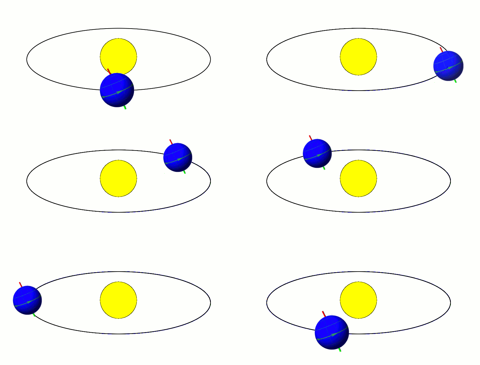
In astronomy, axial tilt, also known as obliquity, is the angle between an object's rotational axis and its orbital axis, which is the line perpendicular to its orbital plane; equivalently, it is the angle between its equatorial plane and orbital plane. It differs from orbital inclination. At an obliquity of 0 degrees, the two axes point in the same direction; that is, the rotational axis is perpendicular to the orbital plane. The rotational axis of Earth, for example, is the imaginary line that passes through both the North Pole and South Pole, whereas the Earth's orbital axis is the line perpendicular to the imaginary plane through which the Earth moves as it revolves around the Sun; the Earth's obliquity or axial tilt is the angle between these two lines. Over the course of an orbital period, the obliquity usually does not change considerably, and the orientation of the axis remains the same relative to the background of stars. This causes one pole to be pointed more to ... [...More Info...] [...Related Items...] OR: [Wikipedia] [Google] [Baidu] |
Neutron Spectrometer
Neutron spectroscopy is a spectroscopic method of measuring atomic and magnetic motions by measuring the kinetic energy of emitted neutrons. The measured neutrons may be emitted directly (for example, by nuclear reactions), or they may scatter off cold matter before reaching the detector. Inelastic neutron scattering observes the change in the energy and wavevector of the neutron as it scatters from a sample. This can be used to probe a wide variety of different physical phenomena such as the motions of atoms (diffusional or hopping), the rotational modes of molecules, sound modes and molecular vibrations, recoil in quantum fluids, magnetic and quantum excitations or even electronic transitions. Since its discovery, neutron spectroscopy has become useful in medicine as it has been applied to radiation protection and radiation therapy. It is also used in nuclear fusion experiments, where the neutron spectrum can be used to infer the plasma temperature, density, and composition, in a ... [...More Info...] [...Related Items...] OR: [Wikipedia] [Google] [Baidu] |


