|
Mastershausen
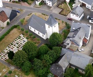
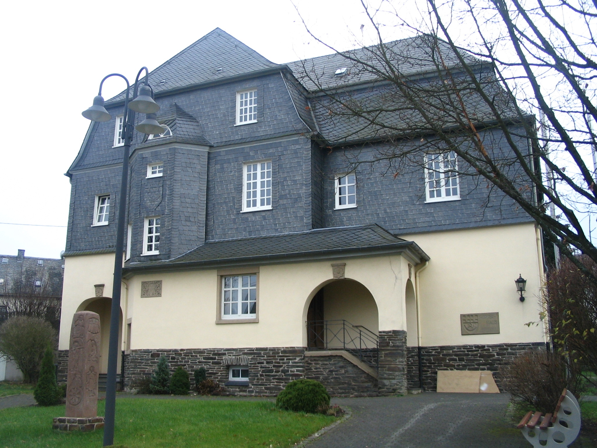
Mastershausen is an ''Ortsgemeinde'' – a municipality belonging to a ''Verbandsgemeinde'', a kind of collective municipality – in the Rhein-Hunsrück-Kreis (district) in Rhineland-Palatinate, Germany. It belongs to the ''Verbandsgemeinde'' of Kastellaun, whose seat is in the like-named town. Geography Location The municipality lies in the Hunsrück near Frankfurt-Hahn Airport, roughly 5 km west of Kastellaun. Through the village runs the road from Buch past the ruin of Castle Balduinseck to Blankenrath. History Finds of coins and vessels bear witness to Celtic settlement on the Burgkopf, a nearby mountain spur, as do remnants of a Roman temple and two grave complexes that have been unearthed. In 1056, Mastershausen had its first documentary mention as ''Malestreshusen''; the church was first mentioned in 1220. Beginning in 1316, Mastershausen, together with 15 neighbouring places, belonged to the ''Amt'' of Balduinseck in the Electorate of Trier. In 1325, Castle Bald ... [...More Info...] [...Related Items...] OR: [Wikipedia] [Google] [Baidu] |
Mastershausen05
Mastershausen is an ''Ortsgemeinde (Germany), Ortsgemeinde'' – a Municipalities of Germany, municipality belonging to a ''Verbandsgemeinde'', a kind of collective municipality – in the Rhein-Hunsrück-Kreis (Districts of Germany, district) in Rhineland-Palatinate, Germany. It belongs to the Kastellaun (Verbandsgemeinde), ''Verbandsgemeinde'' of Kastellaun, whose seat is in the Kastellaun, like-named town. Geography Location The municipality lies in the Hunsrück near Frankfurt-Hahn Airport, roughly 5 km west of Kastellaun. Through the village runs the road from Buch, Rhein-Hunsrück, Buch past the ruin of Castle Balduinseck to Blankenrath. History Finds of coins and vessels bear witness to Celts, Celtic settlement on the Burgkopf, a nearby mountain spur, as do remnants of a Ancient Rome, Roman temple and two grave complexes that have been unearthed. In 1056, Mastershausen had its first documentary mention as ''Malestreshusen''; the church was first mentioned in 1220. Be ... [...More Info...] [...Related Items...] OR: [Wikipedia] [Google] [Baidu] |
Buch, Rhein-Hunsrück
Buch is an ''Ortsgemeinde'' – a municipality belonging to a ''Verbandsgemeinde'', a kind of collective municipality – in the Rhein-Hunsrück-Kreis (district) in Rhineland-Palatinate, Germany. It belongs to the ''Verbandsgemeinde'' of Kastellaun, whose seat is in the like-named town. Geography Location The municipality lies on a ridge in the Hunsrück between the deeply cut valleys of two local streams, the Wohnrother Bach and the Dünnbach at an elevation of some 400 m above sea level. The municipality’s centres (''Ortsteile'') of Buch and Mörz lie some 45 km south-southwest of Koblenz and 4 km west of Kastellaun. History In 1052, Buch had its first documentary mention. In 1332, Louis the Bavarian acknowledged to Archbishop Baldwin of Trier all the holdings of the Archiepiscopal Foundation of Trier, among which were Balduinseck (castle) and Buch. Buch belonged to the Beltheim court. Until the late 15th century, it is known that there was a knightly fa ... [...More Info...] [...Related Items...] OR: [Wikipedia] [Google] [Baidu] |
Kastellaun (Verbandsgemeinde)
Kastellaun is a ''Verbandsgemeinde'' ("collective municipality") in the Rhein-Hunsrück district, in Rhineland-Palatinate, Germany. Its seat is in Kastellaun. On 1 July 2014 it was expanded with 3 municipalities from the former ''Verbandsgemeinde'' Treis-Karden Treis-Karden is an ''Ortsgemeinde'' – a municipality belonging to a ''Verbandsgemeinde'', a kind of collective municipality – in the Cochem-Zell district in Rhineland-Palatinate, Germany. It was the seat of the former like-named ''Verbandsg .... The ''Verbandsgemeinde'' Kastellaun consists of the following ''Ortsgemeinden'' ("local municipalities"): Verbandsgemeinde in Rhineland-Palatinate {{RheinHunsrück-geo-stub ... [...More Info...] [...Related Items...] OR: [Wikipedia] [Google] [Baidu] |
Bell, Rhein-Hunsrück
Bell (Hunsrück) is an ''Ortsgemeinde'' – a municipality belonging to a ''Verbandsgemeinde'', a kind of collective municipality – in the Rhein-Hunsrück-Kreis (district) in Rhineland-Palatinate, Germany. It belongs to the ''Verbandsgemeinde'' of Kastellaun, whose seat is in the like-named town. Geography Location The municipality lies in the Hunsrück. The main centre – there are six ''Ortsteile'' – with its 479 inhabitants (as at 30 June 2009) lies roughly one kilometre from Kastellaun and the ''Hunsrückhöhenstraße'' (“Hunsrück Heights Road”, a scenic road across the Hunsrück built originally as a military road on Hermann Göring’s orders) on the edge of the hollow where the streams rise that form the Mörsdorfer Bach, which flows down to Castle Balduinseck where it empties into the Flaumbach, itself a tributary to the Moselle. Constituent communities Bell’s ''Ortsteile'' are the main centre, also called Bell, and the outlying centres of Hundheim, Krastel ... [...More Info...] [...Related Items...] OR: [Wikipedia] [Google] [Baidu] |
Blankenrath
Blankenrath is an ''Ortsgemeinde'' – a municipality belonging to a ''Verbandsgemeinde'', a kind of collective municipality – in the Cochem-Zell district in Rhineland-Palatinate, Germany. It belongs to the ''Verbandsgemeinde'' of Zell, whose seat is in the municipality of Zell an der Mosel. Geography Location The municipality lies in the Hunsrück, near ''Bundesstraße'' 421. Its lowest elevation is 400 m above sea level and its highest 450 m above sea level. Climate Yearly precipitation in Blankenrath amounts to 856 mm, which is rather high, falling into the highest third of the precipitation chart for all Germany. At 73% of the German Weather Service's weather stations, lower figures are recorded. The driest month is February. The most rainfall comes in June. In that month, precipitation is 1.4 times what it is in February. Precipitation varies minimally and is quite evenly spread over the year. Only 4% of German weather stations report lower seasonal ... [...More Info...] [...Related Items...] OR: [Wikipedia] [Google] [Baidu] |
Hunsrück
The Hunsrück () is a long, triangular, pronounced upland in Rhineland-Palatinate, Germany. It is bounded by the valleys of the Moselle-Saar (north-to-west), the Nahe (south), and the Rhine (east). It is continued by the Taunus mountains, past the Rhine and by the Eifel past the Moselle. To the south of the Nahe is a lower, hilly country forming the near bulk of the Palatinate region and all of the, smaller, Saarland. Below its north-east corner is Koblenz. As the Hunsrück proceeds east it acquires north-south width and three notable gaps in its southern ridges. In this zone are multi-branch headwaters including the Simmerbach ending at Simmertal on the southern edge. This interior is therefore rarely higher than above sea level. Peaks and escarpments are principally: the (Black Forest) Hochwald, the Idar Forest, the Soonwald, and the Bingen Forest. The highest mountain is the Erbeskopf (816 m; 2,677 ft), towards the region's south-west. Notable towns are Simmern ... [...More Info...] [...Related Items...] OR: [Wikipedia] [Google] [Baidu] |
Sosberg
Sosberg is an ''Ortsgemeinde'' – a municipality belonging to a ''Verbandsgemeinde'', a kind of collective municipality – in the Cochem-Zell district in Rhineland-Palatinate, Germany. It belongs to the ''Verbandsgemeinde'' of Zell, whose seat is in the municipality of Zell an der Mosel. Geography The municipality lies on a sloped edge in the Hunsrück between the rivers Moselle, Nahe and Rhine on the one hand and the Idarwald and Soonwald (wooded areas of the Hunsrück) on the other. East of the village runs the Mörsdorfer Bach towards the Moselle. History In 1330, Sosberg had its first documentary mention under the name ''Soysbergh''. The village was until 1781 part of the “Three-Lord Territory”. As in the Beltheim court, the landlordship was shared among the Electorate of Trier, the County of Sponheim and the House of Braunshorn (later Winneburg and Metternich). Beginning in 1794, Sosberg lay under French rule. In 1815 it was assigned to the Kingdom of Prussia at t ... [...More Info...] [...Related Items...] OR: [Wikipedia] [Google] [Baidu] |
Rhein-Hunsrück-Kreis
Rhein-Hunsrück-Kreis is a district (german: Kreis) in the middle of Rhineland-Palatinate, Germany. The neighbouring districts are (from north clockwise) Mayen-Koblenz, Rhein-Lahn, Mainz-Bingen, Bad Kreuznach, Birkenfeld, Bernkastel-Wittlich, Cochem-Zell. History The district was created in 1969, when the districts of St. Goar and Simmern were merged. In 2014 it was expanded with the municipalities Lahr, Mörsdorf and Zilshausen, previously part of Cochem-Zell. Geography The name of the district already mentions the two main geographic features of the district - the river Rhine which forms the boundary to the north-east and the hills of the Hunsrück cover most of the area of the district. The Frankfurt-Hahn Airport is located in the district. Partnerships In 1962, Simmern began a friendship pact with the French region Bourgogne, which was continued after the merging with the St. Goar. In 1985 a partnership was started with the district Nyaruguru (at that time called ... [...More Info...] [...Related Items...] OR: [Wikipedia] [Google] [Baidu] |
Congress Of Vienna
The Congress of Vienna (, ) of 1814–1815 was a series of international diplomatic meetings to discuss and agree upon a possible new layout of the European political and constitutional order after the downfall of the French Emperor Napoleon Bonaparte. Participants were representatives of all European powers and other stakeholders, chaired by Austrian statesman Klemens von Metternich, and held in Vienna from September 1814 to June 1815. The objective of the Congress was to provide a long-term peace plan for Europe by settling critical issues arising from the French Revolutionary Wars and the Napoleonic Wars without the use of (military) violence. The goal was not simply to restore old boundaries, but to resize the main powers so they could balance each other and remain at peace, being at the same time shepherds for the smaller powers. More fundamentally, strongly generalising, conservative thinking leaders like Von Metternich also sought to restrain or eliminate republican ... [...More Info...] [...Related Items...] OR: [Wikipedia] [Google] [Baidu] |
Amt (country Subdivision)
Amt is a type of administrative division governing a group of municipalities, today only in Germany, but formerly also common in other countries of Northern Europe. Its size and functions differ by country and the term is roughly equivalent to a US township or county or English shire district. Current usage Germany Prevalence The ''Amt'' (plural: ''Ämter'') is unique to the German '' Bundesländer'' (federal states) of Schleswig-Holstein, Mecklenburg-Western Pomerania and Brandenburg. Other German states had this division in the past. Some states have similar administrative units called ''Samtgemeinde'' (Lower Saxony), ''Verbandsgemeinde'' ( Rhineland-Palatinate) or '' Verwaltungsgemeinschaft'' ( Baden-Württemberg, Bavaria, Saxony, Saxony-Anhalt, Thuringia). Definition An ''Amt'', as well as the other above-mentioned units, is subordinate to a ''Kreis'' (district) and is a collection of municipalities. The amt is lower than district-level government but higher than ... [...More Info...] [...Related Items...] OR: [Wikipedia] [Google] [Baidu] |
Plurality Voting System
Plurality voting refers to electoral systems in which a candidate, or candidates, who poll more than any other counterpart (that is, receive a plurality), are elected. In systems based on single-member districts, it elects just one member per district and may also be referred to as first-past-the-post (FPTP), single-member plurality (SMP/SMDP), single-choice voting (an imprecise term as non-plurality voting systems may also use a single choice), simple plurality or relative majority (as opposed to an ''absolute majorit''y, where more than half of votes is needed, this is called ''majority voting''). A system which elects multiple winners elected at once with the plurality rule, such as one based on multi-seat districts, is referred to as plurality block voting. Plurality voting is distinguished from ''majority voting'', in which a winning candidate must receive an absolute majority of votes: more than half of all votes (more than all other candidates combined if each voter has ... [...More Info...] [...Related Items...] OR: [Wikipedia] [Google] [Baidu] |


