|
Manila, UT
Manila is a small town located on the northern edge of Daggett County, Utah, United States, just south of the Wyoming border. The town is at the junction of State Route 43 and State Route 44, and is the county seat of Daggett County. Nearby sites include the Flaming Gorge National Recreation Area and the Flaming Gorge Reservoir just east of town, and to the south is Ashley National Forest, which includes Kings Peak (13,528 ft), the highest point in Utah. The population of Manila was 308 at the 2020 census. The settlement was named in 1898, commemorating the American naval victory at the Battle of Manila Bay in the Philippines. Geography and climate File:Flaming Gorge (National Recreational Area) (7063604715).jpg, Flaming Gorge National Recreation Area south of Manila Manila is located in northeastern Utah, north of the Uinta Mountains and west of the Flaming Gorge Reservoir on the Green River. The northern border of the town is the Wyoming state line. Manila h ... [...More Info...] [...Related Items...] OR: [Wikipedia] [Google] [Baidu] |
Town
A town is a type of a human settlement, generally larger than a village but smaller than a city. The criteria for distinguishing a town vary globally, often depending on factors such as population size, economic character, administrative status, or historical significance. In some regions, towns are formally defined by legal charters or government designations, while in others, the term is used informally. Towns typically feature centralized services, infrastructure, and governance, such as municipal authorities, and serve as hubs for commerce, education, and cultural activities within their regions. The concept of a town varies culturally and legally. For example, in the United Kingdom, a town may historically derive its status from a market town designation or City status in the United Kingdom, royal charter, while in the United States, the term is often loosely applied to incorporated municipality, municipalities. In some countries, such as Australia and Canada, distinction ... [...More Info...] [...Related Items...] OR: [Wikipedia] [Google] [Baidu] |
Utah State Route 44
State Route 44 (SR-44) is a state highway in the U.S. state of Utah that runs from US-191 (UT), US-191 at Greendale Junction, Utah, Greendale Junction, southwest of Dutch John, Utah, Dutch John, to SR-43 (UT), SR-43 in Manila, Utah, Manila. The route spans as it straddles the southern and western border of the Flaming Gorge National Recreation Area, and, along with US-191 is part of the Flaming Gorge-Uintas Scenic Byway. The highway was established in 1927, originally going from Manila to Greendale Junction and continuing south to Vernal, Utah, Vernal. However, in 1981, the portion from Vernal to Greendale Junction was truncated in order to designate that road a part of US-191 (UT), US-191. Route description The route begins at the junction of US-191 on the southern boundary of the Flaming Gorge National Recreation Area, southwest of Dutch John, Utah, Dutch John. From there, the route heads west, continuing to straddle the southern boundary of Flaming Gorge National Recreatio ... [...More Info...] [...Related Items...] OR: [Wikipedia] [Google] [Baidu] |
Daggett County Courthouse, Manila, Utah
Daggett may refer to: Places United States * Daggett, California * Daggett, Indiana * Daggett, Michigan * Daggett Township, Michigan * Daggett, Pennsylvania * Daggett County, Utah * Daggett Brook, a stream in Minnesota * Daggett Brook Township, Minnesota People * Aaron Daggett (1837–1938), the last surviving Union general of the American Civil War when he died at the age of 100 * Avalon Daggett (1907–2002), American filmmaker * Beverly Daggett (1945-2015), a politician from Maine * Chris Daggett, (born 1950), Independent candidate for governor of New Jersey in 2009 election * David Daggett (1764–1851), American politician from Connecticut and a founder of the Yale Law School * Hallie Morse Daggett (1878–1964), first woman fire observer for US Forest Service * Harriet Daggett, (1891–1966), American academic and lawyer * Henry J. Daggett (1826–1910), New York assemblyman * Horace Daggett (1931-1998), American politician from Iowa * John Daggett (1833–1919), Li ... [...More Info...] [...Related Items...] OR: [Wikipedia] [Google] [Baidu] |
Green River (Colorado River)
The Green River, located in the western United States, is the chief tributary of the Colorado River. The watershed of the river, known as the Green River Basin, covers parts of the U.S. states of Wyoming, Utah, and Colorado. The Green River is long, beginning in the Wind River Range of Wyoming and flowing through Wyoming and Utah for most of its course, except for a short segment of in western Colorado. Much of the route traverses the arid Colorado Plateau, where the river has carved some of the most spectacular canyons in the United States. The Green is slightly smaller than Colorado when the two rivers merge but typically carries a larger load of silt. The average yearly mean flow of the river at Green River, Utah is per second. The status of the Green River as a tributary of the Colorado River came about mainly for political reasons. In earlier nomenclature, the Colorado River began at its confluence with the Green River. Above the confluence, Colorado was called the Gr ... [...More Info...] [...Related Items...] OR: [Wikipedia] [Google] [Baidu] |
Uinta Mountains
The Uinta Mountains ( ) are an east-west trending mountain range in northeastern Utah extending a short distance into northwest Colorado and slightly into southwestern Wyoming in the United States. As a subrange of the Rocky Mountains, they are unusual for being the highest range in the contiguous United States running east to west, and lie approximately east of Salt Lake City. The range has peaks ranging from , with the highest point being Kings Peak, also the highest point in Utah. The Mirror Lake Highway crosses the western half of the Uintas on its way to Wyoming. Utah State Route 44 crosses the east end of the Uintas between Vernal and Manila. Etymology The name "Uinta" derives from the Ute word ''Yoov-we-teuh'', meaning "pine forest" or "pine tree". Geology The Uinta Mountains are Laramide uplifted metasedimentary rocks deposited in an intracratonic basin in southwest Laurentia during the time of the breakup of the supercontinent Rodinia. The marine and fluvial m ... [...More Info...] [...Related Items...] OR: [Wikipedia] [Google] [Baidu] |
Philippines
The Philippines, officially the Republic of the Philippines, is an Archipelagic state, archipelagic country in Southeast Asia. Located in the western Pacific Ocean, it consists of List of islands of the Philippines, 7,641 islands, with a total area of roughly 300,000 square kilometers, which are broadly categorized in Island groups of the Philippines, three main geographical divisions from north to south: Luzon, Visayas, and Mindanao. With a population of over 110 million, it is the world's List of countries and dependencies by population, twelfth-most-populous country. The Philippines is bounded by the South China Sea to the west, the Philippine Sea to the east, and the Celebes Sea to the south. It shares maritime borders with Taiwan to the north, Japan to the northeast, Palau to the east and southeast, Indonesia to the south, Malaysia to the southwest, Vietnam to the west, and China to the northwest. It has Ethnic groups in the Philippines, diverse ethnicities and Culture o ... [...More Info...] [...Related Items...] OR: [Wikipedia] [Google] [Baidu] |
Salt Lake City
Salt Lake City, often shortened to Salt Lake or SLC, is the capital and most populous city of the U.S. state of Utah. It is the county seat of Salt Lake County, the most populous county in the state. The city is the core of the Salt Lake City Metropolitan Statistical Area (MSA), which had a population of 1,257,936 at the 2020 census. Salt Lake City is further situated within a larger metropolis known as the Salt Lake City–Ogden–Provo Combined Statistical Area, a corridor of contiguous urban and suburban development stretched along a segment of the Wasatch Front, comprising a population of 2,746,164 (as of 2021 estimates), making it the 22nd largest in the nation. With a population of 199,723 in 2020, it is the 111th most populous city in the United States. It is also the central core of the larger of only two major urban areas located within the Great Basin (the other being Reno, Nevada). Salt Lake City was founded on July 24, 1847 by settlers led by Brigham Young ... [...More Info...] [...Related Items...] OR: [Wikipedia] [Google] [Baidu] |
University Of Utah Press
The University of Utah Press is the independent publishing branch of the University of Utah and is a division of the J. Willard Marriott Library. Founded in 1949 by A. Ray Olpin, it is also the oldest university press in Utah. The mission of the press is to "publish and disseminate scholarly books in selected fields, as well as other printed and recorded materials of significance to Utah, the region, the country, and the world." The University of Utah Press publishes in the following general subject areas: anthropology, archaeology, Mesoamerican studies, American Indian studies, natural history, nature writing, poetry, Utah and Western history, Mormon studies, Utah and regional guidebooks, and regional titles. The press employs seven people full-time and publishes 25 to 35 titles per year. The press has over 450 books currently in print. Prizes The University of Utah Press awards five annual or biennial prizes for scholarly and/or literary manuscripts. *The Wallace Steg ... [...More Info...] [...Related Items...] OR: [Wikipedia] [Google] [Baidu] |
Battle Of Manila Bay
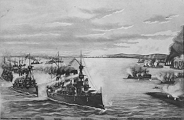
The Battle of Manila Bay (; ), also known as the Battle of Cavite, took place on May 1, 1898, during the Spanish–American War. The American Asiatic Squadron under Commodore George Dewey engaged and destroyed the Spanish Pacific Squadron under ''Contraalmirante'' (Rear admiral) Patricio Montojo. The battle took place in Manila Bay in the Philippines, and was the first major engagement of the Spanish–American War. The battle was one of the most decisive naval battles in history and marked the end of the Spanish colonial period in Philippine history. Tensions between Spain and the United States worsened over the Spanish conduct during their efforts to quell the Cuban War of Independence, with many Americans being agitated by largely falsified reports of Spanish atrocities against the Cuban population. In January 1898, fearing the fate of American interests in Cuba due to the war, the cruiser was dispatched to protect them. Less than a month later, the cruiser explo ... [...More Info...] [...Related Items...] OR: [Wikipedia] [Google] [Baidu] |
Kings Peak (Utah)
Kings Peak is the highest peak in the U.S. state of Utah, with an elevation of . Description Kings Peak is located just south of the spine of the central Uinta Mountains, in the Ashley National Forest in northeastern Utah, in north-central Duchesne County. It lies within the boundaries of the High Uintas Wilderness. The peak is approximately due east of central Salt Lake City, and due north of the town of Duchesne. There are three popular routes to the summit; a scramble up the east slope, a hike up the northern ridge, and a long but relatively easy hike up the southern slope. The peak was named for Clarence King, a surveyor in the area and the first director of the United States Geological Survey The United States Geological Survey (USGS), founded as the Geological Survey, is an agency of the U.S. Department of the Interior whose work spans the disciplines of biology, geography, geology, and hydrology. The agency was founded on Mar .... The easiest route ... [...More Info...] [...Related Items...] OR: [Wikipedia] [Google] [Baidu] |
Ashley National Forest
Ashley National Forest is a United States National Forest, National Forest located in northeastern Utah and southwestern Wyoming. Within the Forest's bounds are (with in Utah and in Wyoming) of vast forests, lakes, and mountains, with elevations ranging from . The forest covers portions of Daggett County, Utah, Daggett, Duchesne County, Utah, Duchesne, Summit County, Utah, Summit, Uintah County, Utah, Uintah, and Utah County, Utah, Utah counties in Utah and Sweetwater County, Wyoming, Sweetwater County in Wyoming. Some of the most popular landmarks located in the forest include the Flaming Gorge National Recreation Area and the Uinta Mountains, which contains the highest mountain peak in Utah (Kings Peak (Utah), Kings Peak). The forest also includes , or about 60.5%, of the High Uintas Wilderness (with the rest being in the Wasatch–Cache National Forest). The headquarters for the Ashley National Forest are located in Vernal, Utah with ranger district offices in Vernal; Duches ... [...More Info...] [...Related Items...] OR: [Wikipedia] [Google] [Baidu] |


