|
Manamelkudi
Manamelkudi is a coastal town in Pudukkottai district, Tamil Nadu, India. It is located in the southeast of the district, on the Palk Strait The Palk Strait ( ta, பாக்கு நீரிணை ''Pākku Nīriṇai'', si, පෝක් සමුද්ර සන්ධිය ''Pok Samudra Sandhiya'') is a strait between the Tamil Nadu state of India and the Jaffna Distric ... coast. State Highway 200 runs through the town, which is the headquarters and namesake of Manamelkudi taluk. The town, which is spread over 1135 hectares, had a population of 7,033 in 2011, resulting in an average population density of .https://censusindia.gov.in/2011census/dchb/3320_PART_B_DCHB_PUDUKKOTTAI.pdf References Villages in Pudukkottai district {{Pudukkottai-geo-stub ... [...More Info...] [...Related Items...] OR: [Wikipedia] [Google] [Baidu] |
Manamelkudi Taluk
Manamelkudi taluk is a taluk of Pudukkottai district of the Indian state of Tamil Nadu. The headquarters of the taluk is the town of Manamelkudi Manamelkudi is a coastal town in Pudukkottai district, Tamil Nadu, India. It is located in the southeast of the district, on the Palk Strait The Palk Strait ( ta, பாக்கு நீரிணை ''Pākku Nīriṇai'', si, පෝ� .... Demographics According to the 2011 census, the taluk of Manamelkudi had a population of 86,589 with 42,945 males and 43,644 females. There were 1016 women for every 1000 men. The taluk had a literacy rate of 74.79. Child population in the age group below 6 was 4,484 males and 4,397 females. Rain Fall The town gets major rainfall during the North east monsoon period. The annual normal rainfall varies from 300 mm to 800 mm. Schools and colleges Schools & colleges are located in this town. Half of the pupils get their education from government and government aided schools. ... [...More Info...] [...Related Items...] OR: [Wikipedia] [Google] [Baidu] |
Pudukkottai District
Pudukkottai District is one of the 38 districts of Tamil Nadu state in southern India. The city of Pudukkottai is the district headquarters. It is also known colloquially as ''Pudhugai.'' Pudukkottai district is bounded on the northeast and east by Thanjavur District, on the southeast by the Palk Strait, on the southwest by Ramanathapuram and Sivaganga districts, and on the west and northwest by Tiruchirapalli District. As of 2011, the district had a population of 1,618,345 with a sex-ratio of 1,015 females for every 1,000 males. The district has an area of 4,663 km² with a coastline of 42 km. The district lies between 78° 25' and 79° 15' east longitude and between 9° 50' and 10° 40' of the north latitude. Organisation On 14 January 1975, Pudukkottai was organised as a separate district comprising the former Pudukkottai Division of Tiruchirappalli district with some additions from Thanjavur district. At present, this district is composed of three revenue div ... [...More Info...] [...Related Items...] OR: [Wikipedia] [Google] [Baidu] |
Palk Strait
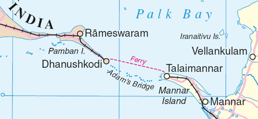
The Palk Strait ( ta, பாக்கு நீரிணை ''Pākku Nīriṇai'', si, පෝක් සමුද්ර සන්ධිය ''Pok Samudra Sandhiya'') is a strait between the Tamil Nadu state of India and the Jaffna District of the Northern Province of the island nation of Sri Lanka. It connects the Bay of Bengal in the northeast with Palk Bay in the southwest. With a minimum depth of less than 9.1 m,Palk Bay Sea Seek. it is 40 to 85 miles (64 to 137 km) wide and 85 miles long.Palk Strait Encyclopedia britannica. Several rivers flow into it, including the Vaigai River of Tamil Na ... [...More Info...] [...Related Items...] OR: [Wikipedia] [Google] [Baidu] |
