|
Maloyaroslavets
Maloyaroslavets () is a town and the administrative center of Maloyaroslavetsky District in Kaluga Oblast, Russia, located on the right bank of the Luzha River ( Oka's basin), northeast of Kaluga, the administrative center of the oblast. Population: 21,200 (1970). History It was founded in the late 14th century by Vladimir the Bold and named Yaroslavets after his son Yaroslav. In 1485, the town was annexed by the Grand Duchy of Moscow and renamed Maloyaroslavets to distinguish it from Yaroslavl. During the French invasion of Russia, the Battle of Maloyaroslavets took place near this town on October 12 (24) of 1812. The battle was commemorated by a roomy cathedral built at the Black Island (Chyornoostrovsky) Convent of Maloyaroslavets by 1843. A number of fierce battles were also fought near Maloyaroslavets during the Battle of Moscow in 1941–1942. The town was under German occupation from 18 October 1941 until 2 January 1942. In late 1941, the Germans operated the ... [...More Info...] [...Related Items...] OR: [Wikipedia] [Google] [Baidu] |
Battle Of Maloyaroslavets
The Battle of Maloyaroslavets took place on 24 October 1812 as part of the French invasion of Russia. It was Kutuzov's decisive battle to force Napoleon to retreat northwest over Mozhaisk to Smolensk on the devastated route of his advance with a higher probability of starvation. Kutuzov's next attack against the remnants of the , the Battle of Krasnoi, began on 15 November 1812, three weeks later. Prelude The last major battle had been the Battle of Tarutino on 18 October 1812, that was won by the Russian army. A great part of the large mob of non-combatants, invalids from the hospitals, women, fugitive inhabitants of Moscow, whose number can only be guessed at, was directed upon Vereya and the straight road to Smolensk and only the fighting force was to march towards Kaluga. On 19 October 1812, Napoleon had retreated from Moscow and marched south-west to Kaluga, Eugène de Beauharnais leading the advance The French army leaving Moscow was estimated by Wilson: 90,000 effect ... [...More Info...] [...Related Items...] OR: [Wikipedia] [Google] [Baidu] |
Maloyaroslavetsky District
Maloyaroslavetsky District () is an administrativeCharter of Kaluga Oblast and municipalLaw #7-OZ district (raion), one of the twenty-four in Kaluga Oblast, Russia. It is located in the northeast of the oblast. The area of the district is . Its administrative center is the town of Maloyaroslavets Maloyaroslavets () is a town and the administrative center of Maloyaroslavetsky District in Kaluga Oblast, Russia, located on the right bank of the Luzha River ( Oka's basin), northeast of Kaluga, the administrative center of the oblast. Pop .... Population: The population of Maloyaroslavets accounts for 60.9% of the district's total population. References Notes Sources * * {{Use mdy dates, date=March 2016 Districts of Kaluga Oblast ... [...More Info...] [...Related Items...] OR: [Wikipedia] [Google] [Baidu] |
Kaluga Oblast
Kaluga Oblast () is a federal subjects of Russia, federal subject of Russia (an oblast). Its administrative center is the types of inhabited localities in Russia, city of Kaluga. The Russian Census (2021), 2021 Russian Census found a population of 1,069,904. Geography Kaluga Oblast lies in the central part of the East European Plain. The oblast's territory is located between the Central Russian Upland (with and average elevation of above and a maximum elevation of in the southeast), the Smolensk–Moscow Upland, and the Dnieper–Desna River, Desna watershed. Most of the oblast is occupied by plains, fields, and forests with diverse flora and fauna. The administrative center is located on the Baryatino-Sukhinichy plain. The western part of the oblast — located within the drift plain — is dominated by the Spas-Demensk ridge. To the south is an outwash plain that is part of the Bryansk-Zhizdra woodlands, with average elevation up to 200 m. From north to south, Kaluga ... [...More Info...] [...Related Items...] OR: [Wikipedia] [Google] [Baidu] |
French Invasion Of Russia
The French invasion of Russia, also known as the Russian campaign (), the Second Polish War, and in Russia as the Patriotic War of 1812 (), was initiated by Napoleon with the aim of compelling the Russian Empire to comply with the Continental System, continental blockade of the United Kingdom. Widely studied, Napoleon's incursion into Russia stands as a focal point in military history, recognized as among the list of battles by casualties, most devastating military endeavors globally. In a span of fewer than six months, the campaign exacted a staggering toll, claiming the lives of nearly a million soldiers and civilians. On 24 June 1812 and subsequent days, the initial wave of the multinational Grande Armée crossed the Neman River, marking the entry from the Duchy of Warsaw into Russia. Employing extensive forced marches, Napoleon rapidly advanced his army of nearly half a million individuals through European Russia, Western Russia, encompassing present-day Belarus, in a b ... [...More Info...] [...Related Items...] OR: [Wikipedia] [Google] [Baidu] |
Battle Of Moscow
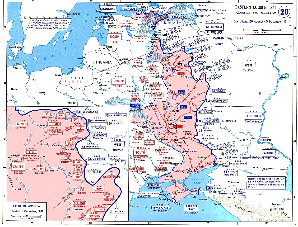
The Battle of Moscow was a military campaign that consisted of two periods of strategically significant fighting on a sector of the Eastern Front during World War II, between October 1941 and January 1942. The Soviet defensive effort frustrated Hitler's attack on Moscow, the capital and largest city of the Soviet Union. Moscow was one of the primary military and political objectives for Axis forces in their invasion of the Soviet Union. The German Strategic Offensive, named Operation Typhoon, called for two pincer offensives, one to the north of Moscow against the Kalinin Front by the 3rd and 4th Panzer Armies, simultaneously severing the Moscow–Leningrad railway, and another to the south of Moscow Oblast against the Western Front south of Tula, by the 2nd Panzer Army, while the 4th Army advanced directly towards Moscow from the west. Initially, the Soviet forces conducted a strategic defence of Moscow Oblast by constructing three defensive belts, deploying newly r ... [...More Info...] [...Related Items...] OR: [Wikipedia] [Google] [Baidu] |
Barysaw
Barysaw or Borisov (, ; , ) is a city in Minsk Region, Belarus. It serves as the administrative center of Barysaw District. It is located on the Berezina, Berezina River and north-east from the capital Minsk. As of 2025, it has a population of 134,732. History Early history Barysaw is first mentioned in the Laurentian Codex as being founded (as Borisov) in 1102 by the Prince of Polotsk Rogvolod Vseslavich, who had the baptismal name of Boris (given name), Boris. During the next two centuries, it was burned and then rebuilt south of where it was before. Under Lithuania From the late 13th century to 1795, the town was part of the Grand Duchy of Lithuania, which was part of the Polish-Lithuanian union since the Union of Krewo (1385) and the Polish–Lithuanian Commonwealth after the Union of Lublin (1569). In 1500, during the Muscovite–Lithuanian Wars#Second war (1500–1503), Lithuanian–Muscovite War, Alexander Jagiellon resided in Barysaw Castle. In 1563, it was granted Magd ... [...More Info...] [...Related Items...] OR: [Wikipedia] [Google] [Baidu] |
Luzha River
The Luzha () is a river in Kaluga Oblast, Russia, which originates in Moscow Oblast. It is a right tributary of the Protva (in the Oka river basin). The Luzha has a length of and a area of .«Река ЛУЖА» Russian State Water Registry The Luzha freezes up in November (rarely in December) and breaks up in April. The town of |
Western Front (Soviet Union)
The Western Front was a front of the Red Army, one of the Red Army Fronts during World War II. The Western Front was created on 22 June 1941 from the Western Special Military District (which before July 1940 was known as Belorussian Special Military District). The first Front Commander was Dmitry Pavlov (continuing from his position as District Commander since June 1940). The western boundary of the Front in June 1941 was long, from the southern border of Lithuania to the Pripyat River and the town of Włodawa. It connected with the adjacent North-Western Front, which extended from the Lithuanian border to the Baltic Sea, and the Southwestern Front in Ukraine. Operational history Front dispositions 22 June 1941 The 1939 partition of Poland according to the Molotov–Ribbentrop Pact established a new western border with no permanent defense installations, and the army deployment within the Front created weak flanks. At the outbreak of war with Germany, the Western Spec ... [...More Info...] [...Related Items...] OR: [Wikipedia] [Google] [Baidu] |
Aleksin
Aleksin () is a town and the administrative center of Aleksinsky District in Tula Oblast, Russia, located northwest of Tula, the administrative center of the oblast. Population: History It was founded at the end of the 13th century and first mentioned in 1348 in the Nikon Chronicle. Aleksin was sacked by Khan Akhmat in 1472 during his invasion of the Grand Duchy of Moscow. Because of its location on the Oka River, it was, for a while, an important inland port. Aleksin was granted town status in 1777. The town expanded in the 1930s with the construction of a chemical plant. During World War II, Aleksin was under German occupation from 29 November 1941 until 17 December 1941. On the night of 8–9 November 2024, during the Russo-Ukrainian War, Ukraine launched a drone attack on the Aleksin Chemical Plant—a subsidiary of state corporation Rostec—about south of Moscow, causing a series of explosions and fires at the plant which manufactures ammunition and explosi ... [...More Info...] [...Related Items...] OR: [Wikipedia] [Google] [Baidu] |
Serpukhov
Serpukhov ( rus, Серпухов, p=ˈsʲerpʊxəf) is a types of inhabited localities in Russia, city in Moscow Oblast, Russia, located at the confluence of the Oka River, Oka and the Nara (Oka), Nara Rivers, 99 kilometers (62 miles) south from Moscow and 72 kilometers (45 miles) from Moscow Ring Road on the Moscow—Simferopol highway. The Moscow—Tula, Russia, Tula railway passes through Serpukhov. Serpukhov is at the centre of the Serpukhov Urban District which in turn lies at the heart of the with a population of more than 260,000 inhabitants. In the 14th and early 15th centuries, Serpukhov was the capital of the principality. It was allocated to an independent administrative and economic unit with direct subordination to the executive committee of the regional council on September 14, 1939. Now a city of regional subordination, it is part of the municipality of the city district of Serpukhov. In the modern era, Serpukhov became a local industrial center with textile, m ... [...More Info...] [...Related Items...] OR: [Wikipedia] [Google] [Baidu] |
Ischia
Ischia ( , , ) is a volcanic island in the Tyrrhenian Sea. It lies at the northern end of the Gulf of Naples, about from the city of Naples. It is the largest of the Phlegrean Islands. Although inhabited since the Bronze Age, as a Ancient Greece, Greek Emporium (antiquity), emporium it was founded in the 8th or 9th century Common Era, BCE, and known as wikt:Πιθηκοῦσαι, Πιθηκοῦσαι, ''Pithekoūsai''. Roughly trapezoidal in shape, it measures approximately east to west and north to south and has about of coastline and a surface area of . It is almost entirely mountainous; the highest peak is Mount Epomeo, at . The island is very densely populated, with 60,000 residents (more than 1,300 inhabitants per square km). Ischia, Campania, Ischia is the name of the main ''comune'' of the island. The other ''comuni'' of the island are Barano d'Ischia, Casamicciola Terme, Forio, Lacco Ameno and Serrara Fontana. Geology and geography The roughly trapezoidal island ... [...More Info...] [...Related Items...] OR: [Wikipedia] [Google] [Baidu] |


