|
Malampa
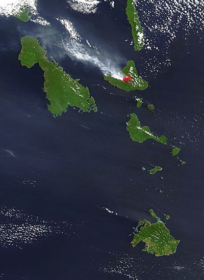
Malampa is one of the six provinces of Vanuatu, located in the center of the country. It consists of three main islands: Malakula, Ambrym and Paama, and takes its name from the first syllable of their names. It includes a number of other islands – the small islands of Uripiv, Norsup, Rano, Wala, Atchin and Vao off the coast of Malakula, and the volcanic island of Lopevi (currently uninhabited). Also included are the Maskelynes Islands and some more small islands along the south coast of Malakula. Population It has a population of 36,722 (2009 census) - Government of Vanuatu people and an area of 2,779 km2. Its capital is |
Provinces Of Vanuatu
Vanuatu has been divided into six provinces since 1994. The names in English of all provinces are derived from the initial letters of their constituent islands: Municipalities The provinces are in turn divided into municipalities headed by a council and a mayor elected from among the members of the council. In Tafea Province, for example, are the following municipalities (council areas): *North Erromango *South Erromango *North Tanna *West Tanna *Middle Bush Tanna *Whitesands *South West Tanna *South Tanna The islands of Aniwa, Futuna and Aneityum appear to consist of one municipality each. Island regions (historical) From 1985 to 1994 it was divided into eleven island regions: Districts (historical) During the Condominium era, specifically from 1968 to 1984 the group was divided into four administrative districts: Districts (1950) In the 1950s, districts appeared to denote the finest administrative level, finer than the current municipalities or council are ... [...More Info...] [...Related Items...] OR: [Wikipedia] [Google] [Baidu] |
Malampa Province
Malampa is one of the six provinces of Vanuatu, located in the center of the country. It consists of three main islands: Malakula, Ambrym and Paama, and takes its name from the first syllable of their names. It includes a number of other islands – the small islands of Uripiv, Norsup, Rano (Vanuatu), Rano, Wala (island), Wala, Atchin and Vao (island), Vao off the coast of Malakula, and the volcanic island of Lopevi (currently uninhabited). Also included are the Maskelynes Islands and some more small islands along the south coast of Malakula. Population It has a population of 36,722 (2009 census) - Government of Vanuatu people and an area of 2,779 km2. Its capital is Lakatoro on Malakula. Islands Mountain ...
|
Malakula
Malakula, also spelled Malekula, is the second-largest island in the nation of Vanuatu, formerly the New Hebrides, in Melanesia, a region of the Pacific Ocean. Location Malakula is separated from the islands of Espiritu Santo and Malo Island, Malo by the Bougainville Strait. Lakatoro, the capital of Malampa Province, is situated on Malakula's northeastern shore and is the largest settlement on the island. Just off the northeastern coast of Malakula, there is a group of islands called the ''Small Islands'', including, in order from north to south: Vao (island), Vao, Atchin, Wala (island), Wala, Rano (island), Rano, Norsup, Uripiv, and Uri (island), Uri. Also off the coast: Tomman Island to the southwest; Akhamb Island to the south; and the Maskelynes Islands to the southeast (including Sakao Island (Malampa, Vanuatu), Sakao Island and Uluveo). Malakula has a maximum elevation of 879 m. Its peak is called Mt. Liambele. In 1768, Louis Antoine de Bougainville gave his name to the str ... [...More Info...] [...Related Items...] OR: [Wikipedia] [Google] [Baidu] |
Ambrym
Ambrym is a volcanic island in Malampa Province in the archipelago of Vanuatu. Volcanic activity on the island includes lava lakes in two craters near the summit. Etymology Ambrym (also known as ''Ambrin'', ''"ham rim"'' in the Ranon language) was allegedly named by Captain Cook, who is said to have anchored off there in 1774. In fact, his expedition never touched Ambrym. Geography Located near the center of the Vanuatuan archipelago, Ambrym is roughly triangular in shape, about wide. With of surface area, it is the fifth largest island in the country. The summit at the centre of the island is dominated by a desert-like caldera, which covers an area of . With the exception of human settlements, the rest of the island is covered by a dense jungle. Important Bird Area The western part of the island, comprising 17,605 ha of forest, together with gardens around habitation, has been recognised as an Important Bird Area (IBA) by BirdLife International because it supports po ... [...More Info...] [...Related Items...] OR: [Wikipedia] [Google] [Baidu] |
Uripiv
Uripiv is a small inhabited island in Malampa Province of Vanuatu in the Pacific Ocean. Uripiv lies off the north coast of Malekula Island. The estimated terrain elevation above the sea level is some 8 meters. Population As of 2015, the official population of the island was 351 people in 76 households. Local people speak Uripiv language, a dialect of the language spoken on the north-east coast of Malakula Malakula, also spelled Malekula, is the second-largest island in the nation of Vanuatu, formerly the New Hebrides, in Melanesia, a region of the Pacific Ocean. Location Malakula is separated from the islands of Espiritu Santo and Malo Island, Ma .... The language is referred to as Northeast Malakula or Uripiv-Wala-Rano-Atchin, and is spoken on the islands of Uripiv, Wala, Rano, and Atchin and on the mainland opposite to these islands. References Islands of Vanuatu Malampa Province {{Vanuatu-geo-stub ... [...More Info...] [...Related Items...] OR: [Wikipedia] [Google] [Baidu] |
Norsup
Norsup is a town on Malakula Island in Malampa Province, Vanuatu Vanuatu ( or ; ), officially the Republic of Vanuatu (; ), is an island country in Melanesia located in the South Pacific Ocean. The archipelago, which is of volcanic origin, is east of northern Australia, northeast of New Caledonia, east o ... It is located near Lakatoro, the capital of Malampa Province. Population As of 2021, it has a population of 2,998 inhabitants. Transportation The town and surrounding areas are served by Norsup Airport, one of three airports of the island. Others are Lamap Airport and South West Bay Airport. References Populated places in Vanuatu Malampa Province {{Vanuatu-geo-stub ... [...More Info...] [...Related Items...] OR: [Wikipedia] [Google] [Baidu] |
Arseo
Arseo Island is a small, uninhabited island in the Malampa Province of Vanuatu Vanuatu ( or ; ), officially the Republic of Vanuatu (; ), is an island country in Melanesia located in the South Pacific Ocean. The archipelago, which is of volcanic origin, is east of northern Australia, northeast of New Caledonia, east o ... in the Pacific Ocean. The estimated terrain elevation above sea level is some . There are two small neighboring islands: Leumanang and Varo. Population As of 1999, the official local population was 290. However, as of 2009, the island was fully depopulated. References Islands of Vanuatu Malampa Province {{Vanuatu-geo-stub ... [...More Info...] [...Related Items...] OR: [Wikipedia] [Google] [Baidu] |
Paama
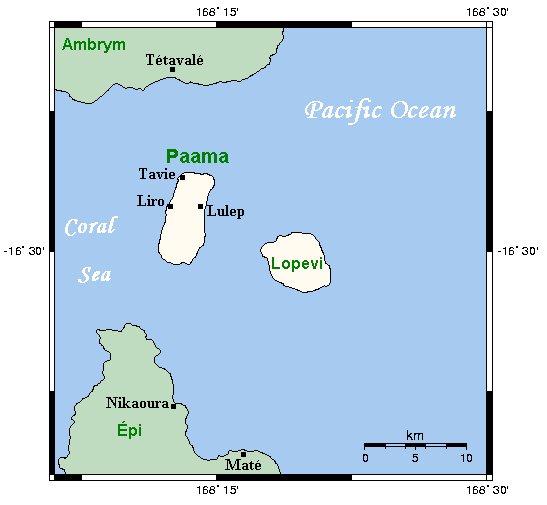
Paama ( Paama language: VoumCrowley, Terry. (1982). ''The Paamese Language of Vanuatu. Pacific Linguistics, Series B – No. 87''. Canberra: ANU Printing Services.) is a small island in Malampa Province, Vanuatu. The island is about 8 km from north to south and only 5 km or so at its widest point. The island is dominated by hills, rising to a height of around 550 m in the north. Paama lies a short distance south of Ambrym, a little further east of Malakula, about 7 km west of the large active volcano Lopevi (Ulvae, in the vernacular (see Crowley 1982), and a short distance north of the island of Epi. During daylight, all of Paama's neighbouring islands are clearly visible from various locations on the island. Indeed, on a clear night, the red glow of Ambrym's twin volcanos can be seen clearly from the black sand beach at Liro. The now uninhabited island of Lopevi dominates the view east from the village of Lulep, on the northeast coast of the island. This ac ... [...More Info...] [...Related Items...] OR: [Wikipedia] [Google] [Baidu] |
Rano (Vanuatu)
Rano is an islet off the north-eastern coast of Malakula Malakula, also spelled Malekula, is the second-largest island in the nation of Vanuatu, formerly the New Hebrides, in Melanesia, a region of the Pacific Ocean. Location Malakula is separated from the islands of Espiritu Santo and Malo Island, Ma ... in Vanuatu in the Pacific Ocean. The 1999 census showed a population of 273, which increased in 2009 to 304.Rano citypopulation.de References Islands of Vanuatu Malampa Province {{vanuatu-geo-stub ...[...More Info...] [...Related Items...] OR: [Wikipedia] [Google] [Baidu] |
Avock
Avock Island or Avokh Island is an inhabited island in Malampa Province of Vanuatu Vanuatu ( or ; ), officially the Republic of Vanuatu (; ), is an island country in Melanesia located in the South Pacific Ocean. The archipelago, which is of volcanic origin, is east of northern Australia, northeast of New Caledonia, east o ... in the Pacific Ocean. The estimated terrain elevation above the sea level is some 166 meters. Population As of 2015, the official population of the island was 189 in 49 households. References Islands of Vanuatu Malampa Province {{Vanuatu-geo-stub ... [...More Info...] [...Related Items...] OR: [Wikipedia] [Google] [Baidu] |
Lakatoro
Lakatoro is the capital of Malampa Province of the island country of Vanuatu. It is situated on the eastern shore of Malakula Malakula, also spelled Malekula, is the second-largest island in the nation of Vanuatu, formerly the New Hebrides, in Melanesia, a region of the Pacific Ocean. Location Malakula is separated from the islands of Espiritu Santo and Malo Island, Ma ... and is the largest settlement in that island. Lakatoro consists of a couple of retail shops, a supermarket, and a local market selling locally farmed goods. Climate Transportation The town is served by Norsup Airport. There is a weekly shipping service from Port Vila (Efate) to Litzlitz (Malekula) to Luganville (Santo). Banking The National Bank of Vanuatu (NBV) is the only bank in Lakatoro. An agent for Australia and New Zealand Banking Group has a representative in Lakatoro who acts as an agent for their GoMoney product. The agent's office is at PIM Trading, next to the Market house. Mobile Telecom ... [...More Info...] [...Related Items...] OR: [Wikipedia] [Google] [Baidu] |

