|
Mahdia Airport
Mahdia Airport is an airport serving the village of Mahdia, in the Potaro-Siparuni Region of Guyana. The airport's only runway is a 1,067-meter grass strip. See also * * * List of airports in Guyana * Transport in Guyana The transport sector comprises the physical infrastructure, docks and vehicle, terminals, fleets, ancillary equipment and service delivery of all the various modes of transport operating in Guyana. The transport services, transport agencies provid ... References External links Mahdia Airport [...More Info...] [...Related Items...] OR: [Wikipedia] [Google] [Baidu] |
Mahdia, Guyana
Mahdia is a town in Guyana, located near the centre of the country at an altitude of . Commerce is centred on the area's gold and diamond mining operations. As such it is affected by the economic booms and busts and attracts immigrants, both local and foreign, to obtain wealth through mining. Demographics The population in Mahdia as of 2012 was 2,563 people, and is of three groups. The Patamonas, an indigenous Amerindian tribe, are involved in farming, hunting and mining. The Coast Landers, residents from the coastlands of Guyana, migrated to the hinterland to seek employment mainly mining. The third group, called Islanders, are immigrants, and their descendants are from the Caribbean Islands, particularly, St Lucia and Dominica. They focus on farming and burning charcoal. Within recent times, there has been an influx of a new group, the Brazilians, who are also involved in mining and other businesses. On 10 September annually, the Amerindians celebrate Heritage Month in t ... [...More Info...] [...Related Items...] OR: [Wikipedia] [Google] [Baidu] |
Potaro-Siparuni
Potaro-Siparuni (Region 8) is a region of Guyana. It borders the region of Cuyuni-Mazaruni to the north, the regions of Upper Demerara-Berbice and East Berbice-Corentyne to the east, the region of Upper Takutu-Upper Essequibo to the south and Brazil to the west. The main villages in the region are Campbelltown, Orinduik, Mahdia, Paramakatoi and Tumatumari. Population The Government of Guyana has administered three official censuses since the 1980 administrative reforms, in 1980, 1991 and 2002. In 2012, the population of Potaro-Siparuni was recorded at 10,190 people. Official census records for the population of Potaro-Siparuni are as follows: *2012 : 10,190 *2002 : 10,095 *1991 : 5,616 *1980 : 4,485 Communities (including name variants): *Arnik Village * Campbelltown *Itabac *Kamana Village *Kanapang Village * Kato (Kato Village, Karto) *Kopinang Mission *Mahdia * Micobie * Monkey Mountain * Orinduik * Paramakatoi (Paramahatoi) * Potaro Landing *Taruka * Tumatumari * ... [...More Info...] [...Related Items...] OR: [Wikipedia] [Google] [Baidu] |
Guyana
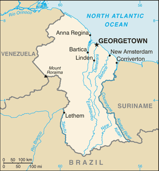
Guyana, officially the Co-operative Republic of Guyana, is a country on the northern coast of South America, part of the historic British West Indies. entry "Guyana" Georgetown, Guyana, Georgetown is the capital of Guyana and is also the country's largest city. Guyana is bordered by the Atlantic Ocean to the north, Brazil to the south and southwest, Venezuela to the west, and Suriname to the east. With a land area of , Guyana is the third-smallest sovereign state by area in mainland South America after Uruguay and Suriname, and is the List of South American countries by population, second-least populous sovereign state in South America after Suriname; it is also List of countries and dependencies by population density, one of the least densely populated countries on Earth. The official language of the country is English language, English, although a large part of the population is bilingual in English and the indigenous languages. It has a wide variety of natural habitats and ... [...More Info...] [...Related Items...] OR: [Wikipedia] [Google] [Baidu] |
List Of Airports In Guyana
This is a list of airports in Guyana, sorted by location. Guyana, officially the Co-operative Republic of Guyana and previously known as British Guiana, is a state on the northern coast of South America. Guyana is bordered to the east by Suriname, to the south and southwest by Brazil, to the west by Venezuela, and to the north by the Atlantic Ocean. It is the only state of the Commonwealth of Nations on mainland South America. Guyana is also a member of the Caribbean Community (CARICOM), which has its secretariat headquarters in Guyana's capital, Georgetown. Airports Airport names shown in bold have scheduled passenger service on commercial airlines. See also * Transport in Guyana * List of airports by ICAO code: S#SY - Guyana * Wikipedia: WikiProject Aviation/Airline destination lists: South America#Guyana References * * - includes IATA codes * . World Aero Data. - ICAO codes, airport data Airports in Guyana Great Circle Mapper. - IATA and ICAO codes {{South ... [...More Info...] [...Related Items...] OR: [Wikipedia] [Google] [Baidu] |
Transport In Guyana
The transport sector comprises the physical infrastructure, docks and vehicle, terminals, fleets, ancillary equipment and service delivery of all the various modes of transport operating in Guyana. The transport services, transport agencies providing these services, the organizations and people who plan, build, maintain, and operate the system, and the policies that mold its development. City transportation Public transport around Guyana's capital Georgetown is provided by privately owned mini buses which operate in allocated zones for which there is a well-regulated fare structure. This arrangement extends to all mini bus routes throughout the country. There are designated bus stops for mini buses for most routes but some buses still pick up passengers at virtually any point on their routes. This practice often poses a serious inconvenience to other vehicles by disrupting the normal flow of traffic. Taxis have freer movement around the city and into rural areas. Their fare, whi ... [...More Info...] [...Related Items...] OR: [Wikipedia] [Google] [Baidu] |

