|
Leiden
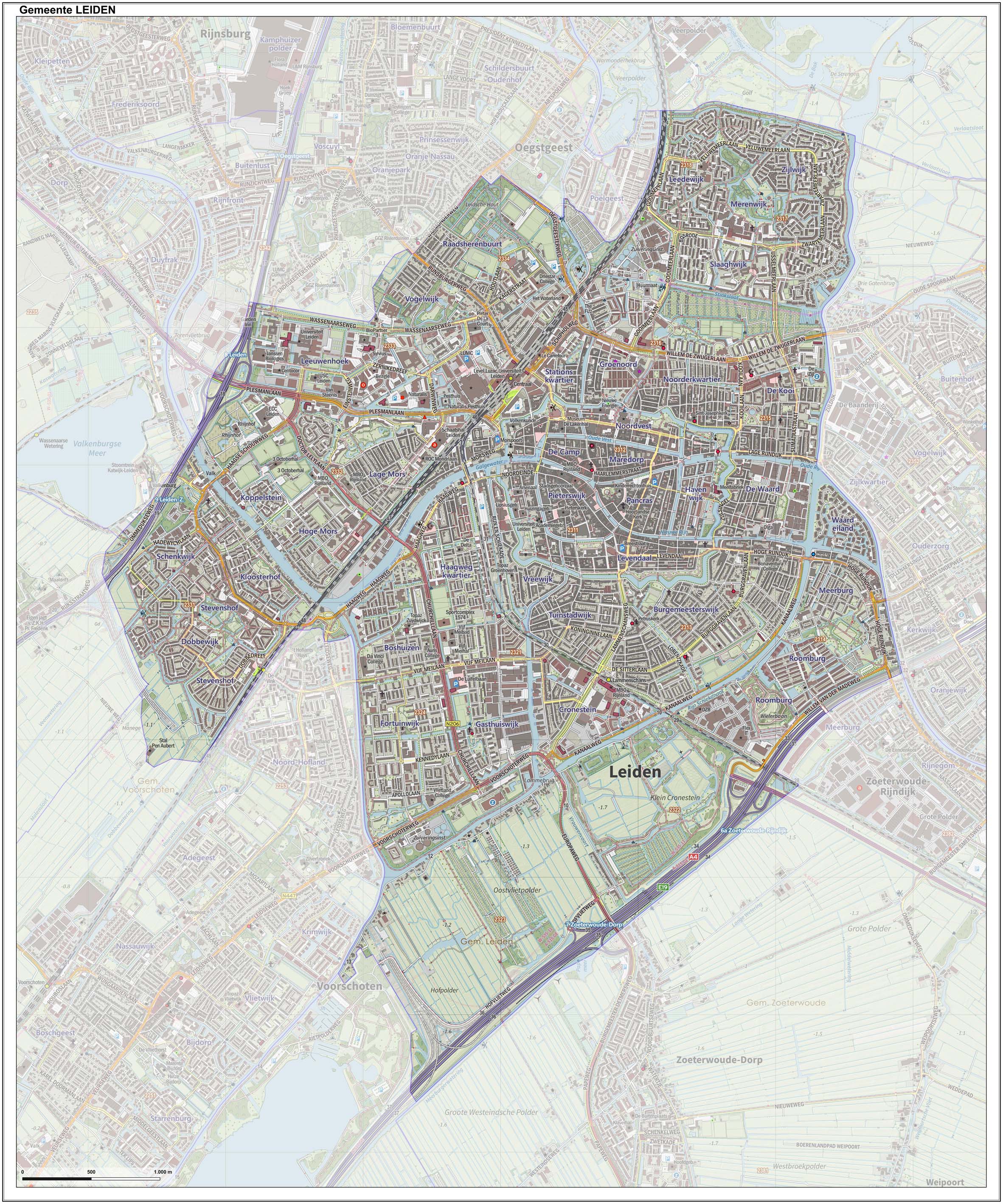
Leiden (; in English and archaic Dutch also Leyden) is a city and municipality in the province of South Holland, Netherlands. The municipality of Leiden has a population of 119,713, but the city forms one densely connected agglomeration with its suburbs Oegstgeest, Leiderdorp, Voorschoten and Zoeterwoude with 206,647 inhabitants. The Netherlands Central Bureau of Statistics (CBS) further includes Katwijk in the agglomeration which makes the total population of the Leiden urban agglomeration 270,879, and in the larger Leiden urban area also Teylingen, Noordwijk, and Noordwijkerhout are included with in total 348,868 inhabitants. Leiden is located on the Oude Rijn, at a distance of some from The Hague to its south and some from Amsterdam to its north. The recreational area of the Kaag Lakes ( Kagerplassen) lies just to the northeast of Leiden. A university city since 1575, Leiden has been one of Europe's most prominent scientific centres for more than four centuries ... [...More Info...] [...Related Items...] OR: [Wikipedia] [Google] [Baidu] |
Katwijk
Katwijk (), also spelled Katwyk, is a coastal municipality and town in the province of South Holland, which is situated in the mid-western part of the Netherlands. The Oude Rijn ("Old Rhine") river flows through the town and into the North Sea. Katwijk is located on the North Sea, northwest of Leiden and 16 km north of The Hague. It shares its borders with the municipalities of Noordwijk, Teylingen, Oegstgeest, Leiden, and Wassenaar. In August 2020, Katwijk had a population of 65.929 and covers an area of , of which is water. Katwijk is by far the largest town in the Duin- en Bollenstreek ("Dune and Bulb Region"). Districts The town consists of a number of districts, including namesakes Katwijk aan den Rijn and Katwijk aan Zee. On 1 January 2005 the various districts had the following populations: :* Katwijk aan den Rijn (5,916) :*Katwijk aan Zee (22,405) :* Katwijk-Noord (13,845) :* Rijnsburg (15,450) :* Valkenburg (3,904) Lying on the coast, Katwijk aan Zee is ( ... [...More Info...] [...Related Items...] OR: [Wikipedia] [Google] [Baidu] |
South Holland
South Holland ( nl, Zuid-Holland ) is a province of the Netherlands with a population of over 3.7 million as of October 2021 and a population density of about , making it the country's most populous province and one of the world's most densely populated areas. Situated on the North Sea in the west of the Netherlands, South Holland covers an area of , of which is water. It borders North Holland to the north, Utrecht and Gelderland to the east, and North Brabant and Zeeland to the south. The provincial capital is the Dutch seat of government The Hague, while its largest city is Rotterdam. The Rhine-Meuse-Scheldt delta drains through South Holland into the North Sea. Europe's busiest seaport, the Port of Rotterdam, is located in South Holland. History Early history Archaeological discoveries in Hardinxveld-Giessendam indicate that the area of South Holland has been inhabited since at least c. 7,500 years before present, probably by nomadic hunter-gatherers. Agriculture and per ... [...More Info...] [...Related Items...] OR: [Wikipedia] [Google] [Baidu] |
The Hague
The Hague ( ; nl, Den Haag or ) is a city and municipality of the Netherlands, situated on the west coast facing the North Sea. The Hague is the country's administrative centre and its seat of government, and while the official capital of the Netherlands is Amsterdam, The Hague has been described as the country's de facto capital. The Hague is also the capital of the province of South Holland, and the city hosts both the International Court of Justice and the International Criminal Court. With a population of over half a million, it is the third-largest city in the Netherlands, after Amsterdam and Rotterdam. The Hague is the core municipality of the Greater The Hague urban area, which comprises the city itself and its suburban municipalities, containing over 800,000 people, making it the third-largest urban area in the Netherlands, again after the urban areas of Amsterdam and Rotterdam. The Rotterdam–The Hague metropolitan area, with a population of approximately ... [...More Info...] [...Related Items...] OR: [Wikipedia] [Google] [Baidu] |
Oegstgeest
Oegstgeest () is a town and municipality in the province of South Holland in the western Netherlands. Its population was in . Etymology The portion ''geest'' in the name refers to the geest lands, which were excavated in the seventeenth century for the benefit of the urban expansion of Leiden. There exists more uncertainty about the 'Oegst' part. There are various stories. The name was formerly often spelled Oestgeest or Oostgeest, which could indicate the geographical location of the village: east of the geest lands. However, the oldest spelling found in a copy of a list of goods of the St. Martin's Cathedral in Utrecht from the tenth century states Osgeresgeest. This could indicate an original resident and owner of the territory: Osger. In the Middle Ages they also spoke of the Church of Kerckwerve if one referred to the Oegstgeester parish church (now the Green Church). History Oegstgeest is one of the earliest inhabited places along the coast. Evidence of a Batavian ... [...More Info...] [...Related Items...] OR: [Wikipedia] [Google] [Baidu] |
Oude Rijn (Utrecht And South Holland)
The Oude Rijn (Old Rhine) is a branch of the Rhine delta in the Dutch provinces of Utrecht and South Holland, starting west of Utrecht, at Harmelen and runs by a mechanical pumping station into the North Sea at Katwijk. Its present-day length is 52 kilometres. In ancient times, the river was the lower part of the main Rhine branch, forking at Batavia Island, now Betuwe, in a northern branche, Rhine and southern branche Maas. It was much broader and was influenced by sea-tides. During occupation of the Romans the river formed part of the northern border of the Roman Empire. In medieval times, river Lek became the main draining river for Rhinewater and the Old Rhine was silting. The river still was important as draining river for the surrounding lowlands, for clay-industry and as a transport and trade route. Ships were towed by horse- and humanpower, using a towpath along large sections of the river, many parts of which have been upgraded to (cycling-)roads over time. Description T ... [...More Info...] [...Related Items...] OR: [Wikipedia] [Google] [Baidu] |
Zoeterwoude
Zoeterwoude () is a municipality in the province of South Holland, Western Netherlands. It covers of which is water. It had a population of in . Located to the southeast of Leiden and north of Zoetermeer, the municipality of Zoeterwoude consists of Gelderswoude, Weipoort, Westeinde, Zoeterwoude-Dorp, Zoeterwoude-Rijndijk and Zuidbuurt. Topography ''Dutch topographic map of Zoeterwoude, Sept. 2014. Click to enlarge.'' History The name Zoeterwoude is first mentioned in a document from 1205, which references a certain "Florentius van Sotrewold". It is uncertain if this is a reference to the village. The first confirmed existence is from 1276 when Dirk van Santhorst received the "Soetrewold" fiefdom from Floris V, Count of Holland. Its municipal boundaries were set circa 1300. At that time it was one of the largest municipalities in the Netherlands, but later much land was annexed by surrounding cities, notably Leiden. In 1450, the first bridge between Leiderdorp and Zoeterwou ... [...More Info...] [...Related Items...] OR: [Wikipedia] [Google] [Baidu] |
Leiderdorp
Leiderdorp () is a town and municipality in the western Netherlands, in the province of South Holland near the city of Leiden. It had a population of in . The municipality covers an area of of which is water. Leiderdorp has now become a suburb of the city of Leiden, although the Oude Rijn (Old Rhine) river and the Zijl river separate the two. The HSL-Zuid high-speed rail line between Amsterdam and Brussels crosses Leiderdorp in a tunnel. It is one of the oldest towns in South Holland province and was a base for the Spanish army in the Eighty Years' War. History Excavations have shown that as early as during the Iron Age in the area of current day Leiderdorp hunters and fishers roamed around and lived on the dry places around the river. Roman Period The Rhine, which passes through Leiderdorp, functioned as the Northern border of the Roman Empire. Close to Leiderdorp, the Romans built a fort, Matilo. Around the fall of the Western Roman Empire the Romans retreated from ... [...More Info...] [...Related Items...] OR: [Wikipedia] [Google] [Baidu] |
Kagerplassen
{{coord, 52, 12, 19, N, 4, 32, 18, E, type:waterbody_region:NL_scale:60000, display=title The ''Kagerplassen'' (a Dutch term meaning "the Kaag Lakes") is a small lake system in South Holland located to the northeast of Leiden.Some of the information in this article is a translation of the Dutch article on the Kagerplassen on the Dutch Wikipedia. The Kaag Lakes are a popular area for boating, watersports, fishing, camping and walking. Windmills, waterfront pasture land (''weilanden'') with grazing animals, quaint Dutch boats and buildings and (in season) flower fields are all part of the charm of boating and walking in this area. Places The Kaag Lakes are part of two municipalities: Kaag en Braassem and Teylingen. Three villages that lay directly on the lakes are: * Warmond (Teylingen) * De Kaag (Kaag en Braassem) * Buitenkaag (Haarlemmermeer, North Holland). A number of other villages and towns (including Leiden itself) are located on connecting waterways providing easy access ... [...More Info...] [...Related Items...] OR: [Wikipedia] [Google] [Baidu] |
Netherlands
) , anthem = ( en, "William of Nassau") , image_map = , map_caption = , subdivision_type = Sovereign state , subdivision_name = Kingdom of the Netherlands , established_title = Before independence , established_date = Spanish Netherlands , established_title2 = Act of Abjuration , established_date2 = 26 July 1581 , established_title3 = Peace of Münster , established_date3 = 30 January 1648 , established_title4 = Kingdom established , established_date4 = 16 March 1815 , established_title5 = Liberation Day , established_date5 = 5 May 1945 , established_title6 = Kingdom Charter , established_date6 = 15 December 1954 , established_title7 = Caribbean reorganisation , established_date7 = 10 October 2010 , official_languages = Dutch , languages_type = Regional languages , languages_sub = yes , languages = , languages2_type = Recognised languages , languages2_sub = yes , languages2 = , demonym = Dutch , capital = Amsterdam , largest_city = capital , ... [...More Info...] [...Related Items...] OR: [Wikipedia] [Google] [Baidu] |
Dutch Language
Dutch ( ) is a West Germanic language spoken by about 25 million people as a first language and 5 million as a second language. It is the third most widely spoken Germanic language The Germanic languages are a branch of the Indo-European language family spoken natively by a population of about 515 million people mainly in Europe, North America, Oceania and Southern Africa. The most widely spoken Germanic language, E ..., after its close relatives German language, German and English language, English. ''Afrikaans'' is a separate but somewhat Mutual intelligibility, mutually intelligible daughter languageAfrikaans is a daughter language of Dutch; see , , , , , . Afrikaans was historically called Cape Dutch; see , , , , , . Afrikaans is rooted in 17th-century dialects of Dutch; see , , , . Afrikaans is variously described as a creole, a partially creolised language, or a deviant variety of Dutch; see . spoken, to some degree, by at least 16 million people, mainly in Sou ... [...More Info...] [...Related Items...] OR: [Wikipedia] [Google] [Baidu] |
Amsterdam
Amsterdam ( , , , lit. ''The Dam on the River Amstel'') is the capital and most populous city of the Netherlands, with The Hague being the seat of government. It has a population of 907,976 within the city proper, 1,558,755 in the urban area and 2,480,394 in the metropolitan area. Located in the Dutch province of North Holland, Amsterdam is colloquially referred to as the "Venice of the North", for its large number of canals, now designated a UNESCO World Heritage Site. Amsterdam was founded at the mouth of the Amstel River that was dammed to control flooding; the city's name derives from the Amstel dam. Originally a small fishing village in the late 12th century, Amsterdam became a major world port during the Dutch Golden Age of the 17th century, when the Netherlands was an economic powerhouse. Amsterdam is the leading center for finance and trade, as well as a hub of production of secular art. In the 19th and 20th centuries, the city expanded and many new neighborho ... [...More Info...] [...Related Items...] OR: [Wikipedia] [Google] [Baidu] |
Teylingen
Teylingen () is a municipality in the Western Netherlands, in the province of South Holland. It was created on 1 January 2006, through the amalgamation of Sassenheim, Voorhout and Warmond. It is named after Teylingen Castle, located in Voorhout. In 2019, it had a population of 37,061. The municipality is bordered by Noordwijkerhout and Lisse to the north, Haarlemmermeer and Alkemade to the east, Leiderdorp and Leiden to the south, Oegstgeest and Katwijk to the west. It is located in an area called the "Dune and Bulb Region" (Duin- en Bollenstreek). The Kagerplassen are to the east of Sassenheim. Population centres * Sassenheim - location of city hall *Teijlingen, with Slot Teylingen *Voorhout *Warmond Topography File:Gem-Teylingen-OpenTopo.jpg, Dutch Topographic map of Teylingen, June 2015 Public transportation Notable people * Herman Boerhaave (1668 in Voorhout – 1738) a Dutch botanist, chemist, Christian humanist and physician * Han Zuilhof (born 1965 in Sassenh ... [...More Info...] [...Related Items...] OR: [Wikipedia] [Google] [Baidu] |


.jpg)
