|
Louisiana Territory
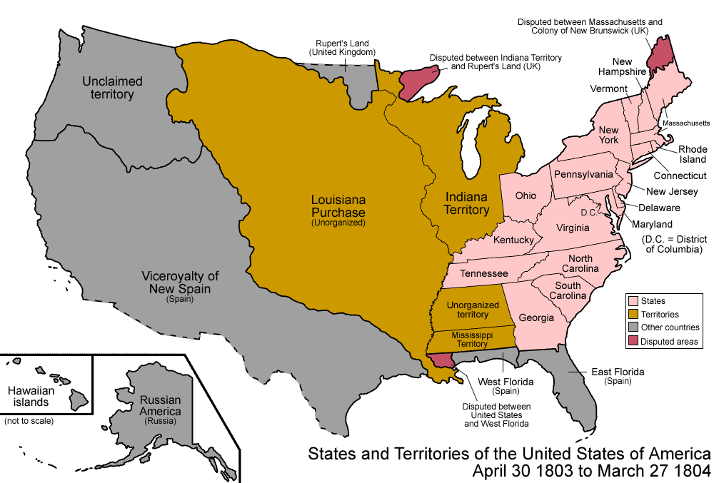
The Territory of Louisiana or Louisiana Territory was an organized incorporated territory of the United States that existed from July 4, 1805, until June 4, 1812, when it was renamed the Missouri Territory. The territory was formed out of the District of Louisiana, which consisted of the portion of the Louisiana Purchase north of the 33rd parallel (which is now the Arkansas–Louisiana state line). Background The Eighth Congress of the United States on March 26, 1804, passed legislation entitled "An act erecting Louisiana into two territories, and providing for the temporary government thereof," which established the Territory of Orleans and the District of Louisiana as organized incorporated U.S. territories. With regard to the District of Louisiana, this organic act, which went into effect on October 1, 1804, detailed the authority of the governor and judges of the Indiana Territory to provide temporary civil jurisdiction over the expansive region. Establishment O ... [...More Info...] [...Related Items...] OR: [Wikipedia] [Google] [Baidu] |
Territory Of Orleans
The Territory of Orleans or Orleans Territory was an organized incorporated territory of the United States, organized incorporated territory of the United States that existed from October 1, 1804, until April 30, 1812, when it was Admission to the Union, admitted to the Union as the State of Louisiana. History In 1804, all of the Louisiana Purchase south of the 33rd parallel north, 33rd parallel became the Orleans Territory, and the remainder became the District of Louisiana. (The District of Louisiana was later renamed the Louisiana Territory; and still later, when the Orleans Territory became the State of Louisiana, the Louisiana Territory was renamed the Missouri Territory.) The Organic Act of 1804, passed on March 26 for October 1 implementation, also created the United States District Court for the District of Orleans—the only time Congress has ever provided a territory with a United States district court equal in its authority and jurisdiction to those of the states. ... [...More Info...] [...Related Items...] OR: [Wikipedia] [Google] [Baidu] |
Mississippi River
The Mississippi River is the main stem, primary river of the largest drainage basin in the United States. It is the second-longest river in the United States, behind only the Missouri River, Missouri. From its traditional source of Lake Itasca in northern Minnesota, it flows generally south for to the Mississippi River Delta in the Gulf of Mexico. With its many tributaries, the Mississippi's Drainage basin, watershed drains all or parts of 32 U.S. states and two Canadian provinces between the Rocky Mountains, Rocky and Appalachian Mountains, Appalachian mountains. The river either borders or passes through the states of Minnesota, Wisconsin, Iowa, Illinois, Missouri, Kentucky, Tennessee, Arkansas, Mississippi, and Louisiana. The main stem is entirely within the United States; the total drainage basin is , of which only about one percent is in Canada. The Mississippi ranks as the world's List of rivers by discharge, tenth-largest river by discharge flow, and the largest ... [...More Info...] [...Related Items...] OR: [Wikipedia] [Google] [Baidu] |
Arkansas County, Arkansas
Arkansas County, officially the County of Arkansas, is a County (United States), county located in the U.S. state of Arkansas. As of the 2020 United States census, 2020 census, the population was 17,149. Located in the Arkansas Delta, the county has two county seats, DeWitt, Arkansas, DeWitt and Stuttgart, Arkansas, Stuttgart. The first of the state's List of counties in Arkansas, 75 present-day counties to be created, Arkansas County was formed from New Madrid County on December 13, 1813, when this area was part of the Missouri Territory. The county was named after the Arkansas River (itself named for the Quapaw, Arkansas tribe), as was the subsequent Arkansas Territory which was later split off from Missouri Territory and eventually admitted to the union as a state. The riverfront areas in the Arkansas Delta were developed for cotton plantations that used enslaved African Americans. Cotton was the major commodity crop before and after the Civil War. Since then, the county lies ... [...More Info...] [...Related Items...] OR: [Wikipedia] [Google] [Baidu] |
New Madrid County, Missouri
New Madrid County ( ; ; ) is a county located in the Bootheel of the U.S. state of Missouri. As of the 2020 census, the population was 16,434. The largest city is Portageville and county seat is New Madrid, located on the northern side of the Kentucky Bend in the Mississippi River, where it has formed an oxbow around an exclave of Fulton County, Kentucky. This feature has also been known as New Madrid Bend or Madrid Bend, for the city. The county was officially organized on October 1, 1812, encompassing most of present-day Arkansas. Named after ''Nuevo Madrid,'' a district located in the region, the area was under Spanish rule following France's cession of Louisiana after being defeated in the Seven Years' War. The Spanish named the district after Madrid, the capital of Spain. The county includes a large part of the New Madrid fault that produced the 1811–12 New Madrid earthquakes. This zone remains geologically active, and had continued to produce smaller earthquak ... [...More Info...] [...Related Items...] OR: [Wikipedia] [Google] [Baidu] |
Cape Girardeau County, Missouri
Cape Girardeau County (commonly called Cape County) is located in the southeastern part of the U.S. state of Missouri; its eastern border is formed by the Mississippi River. At the 2020 census, the population was 81,710. The county seat is Jackson, the first city in the US to be named in honor of President Andrew Jackson. Officially organized on October 1, 1812, the county is named after Ensign Sieur Jean Baptiste de Girardot, an official of the French colonial years. The "cape" in the county's name is named after a former promontory rock overlooking the Mississippi River; this feature was demolished during railroad construction. Cape Girardeau County is the hub of the Cape Girardeau–Jackson metropolitan area. Its largest city is Cape Girardeau. History Cape Girardeau County was organized on October 1, 1812, as one of five original counties in the Missouri Territory after the US made the Louisiana Purchase of 1803. It is named after Ensign Sieur Jean Baptiste de Girardo ... [...More Info...] [...Related Items...] OR: [Wikipedia] [Google] [Baidu] |
United States Census Bureau
The United States Census Bureau, officially the Bureau of the Census, is a principal agency of the Federal statistical system, U.S. federal statistical system, responsible for producing data about the American people and American economy, economy. The U.S. Census Bureau is part of the United States Department of Commerce, U.S. Department of Commerce and its Director of the United States Census Bureau, director is appointed by the president of the United States. Currently, Ron S. Jarmin is the acting director of the U.S. Census Bureau. The Census Bureau's primary mission is conducting the United States census, U.S. census every ten years, which allocates the seats of the United States House of Representatives, U.S. House of Representatives to the U.S. state, states based on their population. The bureau's various censuses and surveys help allocate over $675 billion in federal funds every year and it assists states, local communities, and businesses in making informed decisions. T ... [...More Info...] [...Related Items...] OR: [Wikipedia] [Google] [Baidu] |
Missouri
Missouri (''see #Etymology and pronunciation, pronunciation'') is a U.S. state, state in the Midwestern United States, Midwestern region of the United States. Ranking List of U.S. states and territories by area, 21st in land area, it borders Iowa to the north, Illinois, Kentucky and Tennessee to the east, Arkansas to the south and Oklahoma, Kansas, and Nebraska to the west. In the south are the Ozarks, a forested highland, providing timber, minerals, and recreation. At 1.5 billion years old, the St. Francois Mountains are among the oldest in the world. The Missouri River, after which the state is named, flows through the center and into the Mississippi River, which makes up the eastern border. With over six million residents, it is the List of U.S. states and territories by population, 19th-most populous state of the country. The largest urban areas are St. Louis, Kansas City, Missouri, Kansas City, Springfield, Missouri, Springfield, and Columbia, Missouri, Columbia. The Cap ... [...More Info...] [...Related Items...] OR: [Wikipedia] [Google] [Baidu] |
1810 United States Census
The 1810 United States census was the third census conducted in the United States. It was conducted on August 6, 1810. It showed that 7,239,881 people were living in the United States, of whom 1,191,362 were slaves. The 1810 census included one new state: Ohio. The original census returns for the District of Columbia, Georgia, Mississippi, New Jersey, and Ohio were lost or destroyed over the years. Most of Tennessee's original forms were also lost, other than Grainger and Rutherford counties. This was the first census in which New York was ranked as the most populous state, if excluding West Virginia from Virginia. Otherwise this would be the last census with Virginia ranked as the most populous state. Census questions The 1810 census form contained the following information (identical to the 1800 census): # City or township # Name of the head of family # Number of free white males under age 10 # Number of free white males age 10 to under 16 # Number of free white males age 16 ... [...More Info...] [...Related Items...] OR: [Wikipedia] [Google] [Baidu] |
Osage Nation
The Osage Nation ( ) () is a Midwestern Native American nation of the Great Plains. The tribe began in the Ohio and Mississippi river valleys around 1620 A.D along with other groups of its language family, then migrated west in the 17th century due to Iroquois incursions. The term "Osage" is a French version of the tribe's name, which can be roughly translated as "calm water". The Osage people refer to themselves in their Dhegihan Siouan language as (). By the early 19th century, the Osage had become the dominant power in the region, feared by neighboring tribes. The tribe controlled the area between the Missouri and Red rivers, the Ozarks to the east and the foothills of the Wichita Mountains to the south. They depended on nomadic buffalo hunting and agriculture. The 19th-century painter George Catlin described the Osage as "the tallest race of men in North America, either red or white skins; there being ... many of them six and a half, and others taller than seven f ... [...More Info...] [...Related Items...] OR: [Wikipedia] [Google] [Baidu] |
Adams–Onís Treaty
The Adams–Onís Treaty () of 1819, also known as the Transcontinental Treaty, the Spanish Cession, the Florida Purchase Treaty, or the Florida Treaty,Weeks, p. 168. was a treaty between the United States and Spain in 1819 that ceded Florida to the U.S. and defined the boundary between the U.S. and Mexico (New Spain). It settled a standing border dispute between the two countries and was considered a triumph of American diplomacy. It came during the successful Spanish American wars of independence against Spain. Florida had become a burden to Spain, which could not afford to send settlers or staff garrisons, so Madrid decided to cede the territory to the United States in exchange for settling the boundary dispute along the Sabine River in Spanish Texas. The treaty established the boundary of U.S. territory and claims through the Rocky Mountains and west to the Pacific Ocean, in exchange for Washington paying residents' claims against the Spanish government up to a total of $5 ... [...More Info...] [...Related Items...] OR: [Wikipedia] [Google] [Baidu] |
New Spain
New Spain, officially the Viceroyalty of New Spain ( ; Nahuatl: ''Yankwik Kaxtillan Birreiyotl''), originally the Kingdom of New Spain, was an integral territorial entity of the Spanish Empire, established by Habsburg Spain. It was one of several domains established during the Spanish colonization of the Americas, Spanish conquest of the Americas, and had its capital in Mexico City. Its jurisdiction comprised a large area of the southern and western portions of North America, mainly what became Mexico and the Southwestern United States, but also California, Florida and Louisiana (New Spain), Louisiana; Central America as Mexico, the Caribbean like Hispaniola and Martinique, Martinica, and northern parts of South America, even Colombia; several Pacific archipelagos, including the Philippines and Guam. Additional Asian colonies included "Spanish Formosa", on the island of Taiwan. After the 1521 Spanish conquest of the Aztec Empire, conqueror Hernán Cortés named the territory New S ... [...More Info...] [...Related Items...] OR: [Wikipedia] [Google] [Baidu] |
Spain
Spain, or the Kingdom of Spain, is a country in Southern Europe, Southern and Western Europe with territories in North Africa. Featuring the Punta de Tarifa, southernmost point of continental Europe, it is the largest country in Southern Europe and the fourth-most populous European Union member state. Spanning across the majority of the Iberian Peninsula, its territory also includes the Canary Islands, in the Eastern Atlantic Ocean, the Balearic Islands, in the Western Mediterranean Sea, and the Autonomous communities of Spain#Autonomous cities, autonomous cities of Ceuta and Melilla, in mainland Africa. Peninsular Spain is bordered to the north by France, Andorra, and the Bay of Biscay; to the east and south by the Mediterranean Sea and Gibraltar; and to the west by Portugal and the Atlantic Ocean. Spain's capital and List of largest cities in Spain, largest city is Madrid, and other major List of metropolitan areas in Spain, urban areas include Barcelona, Valencia, Seville, ... [...More Info...] [...Related Items...] OR: [Wikipedia] [Google] [Baidu] |


