|
Long Reach
Long Reach or Longreach may refer to: Places *Long Reach, Columbia, Maryland, United States * Long Reach, Kent, UK *Long Reach, at Gravesend, Kent, UK *Long Reach, West Virginia, United States * Longreach, Queensland, Australia *Long Reach, Tasmania Long Reach is a rural locality in the local government area (LGA) of George Town in the Launceston LGA region of Tasmania. The locality is about south-east of the town of George Town. The 2016 census recorded a population of nil for the stat ..., Australia, near Bell Bay Other uses * Operation Long Reach, part of the 1965 Pleiku Campaign in the Vietnam War {{Disambiguation ... [...More Info...] [...Related Items...] OR: [Wikipedia] [Google] [Baidu] |
Long Reach, Columbia, Maryland
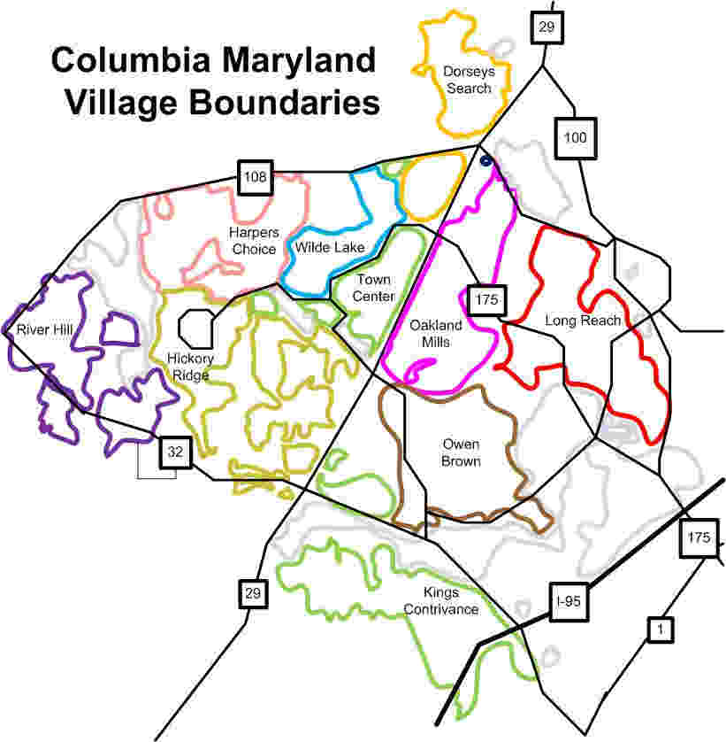
Long Reach, one of ten villages composing Columbia, Maryland, United States, is found in the northeast part of Columbia along Maryland Route 108. Started in 1971, it is one of the oldest villages, and comprises four neighborhoods: Jeffers Hill, Kendall Ridge, Locust Park, and Phelps Luck. The village, with an approximate population of 15,600, is governed by five elected village board members through "Long Reach Community Association, Inc." The Village Office is located in Stonehouse, the community center, which opened in 1974."History of Long Reach" , columbiamaryland.com, accessed May 29, 2009 History The village derives its name from a land grant named Long Reach, patented to and surveyed by Major Edward Dorsey in 1696 next to[...More Info...] [...Related Items...] OR: [Wikipedia] [Google] [Baidu] |
Long Reach, Kent
Long Reach is a low-lying area north of Dartford, Kent, in southeast England, on the south side of the River Thames, east of Erith and the River Darent. It was the site of a pub (the Long Reach Tavern), a fireworks factory, a smallpox hospital and, from 1911, a Vickers airbase that later became RAF Joyce Green. It also gives its name to a Thames Water sewage treatment works. The area is named after the Long Reach (a name given to the longest straight stretch of a river), the stretch of the Thames between St Clement's Reach and Erith Rands. Landmarks Long Reach Tavern (c. 1800s-1957) The Long Reach Tavern was a riverside pub that had a jetty extending into the Thames, enabling its use by barge and tugboat crews. It was recorded as a tied house of the Fleet Brewery in 1865, and in 1866 hosted a bare-knuckle boxing championship match between James Mace and Joseph Goss. Damaged by the North Sea flood of 1953, it was demolished in 1957 to allow construction of new flood embankme ... [...More Info...] [...Related Items...] OR: [Wikipedia] [Google] [Baidu] |
Gravesend
Gravesend is a town in northwest Kent, England, situated 21 miles (35 km) east-southeast of Charing Cross (central London) on the south bank of the River Thames and opposite Tilbury in Essex. Located in the diocese of Rochester, it is the administrative centre of the Borough of Gravesham. Its geographical situation has given Gravesend strategic importance throughout the maritime and communications history of South East England. A Thames Gateway commuter town, it retains strong links with the River Thames, not least through the Port of London Authority Pilot Station and has witnessed rejuvenation since the advent of High Speed 1 rail services via Gravesend railway station. The station was recently refurbished and now has a new bridge. Toponymy Recorded as Gravesham in the Domesday Book of 1086 when it belonged to Odo, Earl of Kent and Bishop of Bayeux, the half-brother of William the Conqueror, its name probably derives from ''graaf-ham'': the home of the reeve or ... [...More Info...] [...Related Items...] OR: [Wikipedia] [Google] [Baidu] |
Long Reach, West Virginia
Long Reach is an unincorporated community in Tyler County, West Virginia, United States. Long Reach is located along the Ohio River and West Virginia Route 2 West Virginia Route 2 is a state highway in the US state of West Virginia. It generally parallels the Ohio River along the western border of the state, from U.S. Route 60 in Huntington (just west of the East End Bridge) northeasterly to U.S. ..., southwest of Friendly. Long Reach is located along a relatively straight portion stretch of the Ohio River. This is the longest and straightest stretch of the entire river. References Unincorporated communities in Tyler County, West Virginia Unincorporated communities in West Virginia West Virginia populated places on the Ohio River {{TylerCountyWV-geo-stub ... [...More Info...] [...Related Items...] OR: [Wikipedia] [Google] [Baidu] |
Longreach, Queensland
Longreach is a town and a locality in the Longreach Region, Queensland, Australia. It is the administrative centre of the Longreach Regional Council, which was established in 2008 as a merger of the former Longreach, Ilfracombe, and Isisford shires. Longreach is a well known tourist destination due to its aviation history and importance. In the , the locality of Longreach had a population of 3,124 people. Geography Longreach is in Central West Queensland, approximately from the coast, west of Rockhampton. The town is on the Tropic of Capricorn in the south-east of the locality. The town is named after the ‘long reach’ of the Thomson River on which it is situated. Lochern National Park is in the south-western part of the locality (formerly in Vergemont). The main industries of the area are cattle, sheep, and, more recently, tourism. The Landsborough Highway enters the locality from the south-east ( Ilfracombe), passes through the town and then exits to the nort ... [...More Info...] [...Related Items...] OR: [Wikipedia] [Google] [Baidu] |
Long Reach, Tasmania
Long Reach is a rural locality in the local government area (LGA) of George Town in the Launceston LGA region of Tasmania. The locality is about south-east of the town of George Town. The 2016 census recorded a population of nil for the state suburb of Long Reach. History Long Reach is a confirmed locality. Geography The waters of the Tamar River Estuary form the south-western boundary. Road infrastructure Route A8 (East Tamar Highway The East Tamar Highway is a highway in Tasmania, Australia. It covers the eastern edge of the Tamar River, from Launceston to the lighthouse at Low Head. It is labelled as route A8, but prior to 1980 was signed as State Route 1. Plans for ...) passes through from south to north. References Towns in Tasmania Localities of George Town Council {{Tasmania-geo-stub ... [...More Info...] [...Related Items...] OR: [Wikipedia] [Google] [Baidu] |


