|
Llanthony
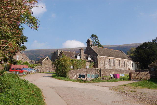
Llanthony ( , ) is a village in the community of Crucorney on the northern edge of Monmouthshire, South East Wales, United Kingdom. Location Llanthony is located in the Vale of Ewyas, a deep and long valley with glacial origins within the Black Mountains, Wales, seven miles north of Abergavenny and within the eastern section of the Brecon Beacons National Park. The village is on an unclassified road leading northwards from Llanvihangel Crucorney to Hay-on-Wye. History Llanthony Priory is situated here; it dates back to about 1100 when a Norman nobleman Walter de Lacy was inspired by an existing chapel to devote himself to solitary prayer and study. He was joined by others and a church was built on the site in 1108. By 1118, a group of about forty monks from England built the priory of Canons Regular, the first in Wales. It was raided regularly by the Welsh and was soon in decline; after Owain Glyndŵr's rebellion in the early 15th century, it seems to have become bare ... [...More Info...] [...Related Items...] OR: [Wikipedia] [Google] [Baidu] |
Llanthony Priory
Llanthony Priory () is a partly ruined former Augustinians, Augustinian priory in the secluded Vale of Ewyas, a steep-sided once-glaciated valley within the Black Mountains, Wales, Black Mountains area of the Brecon Beacons National Park in Monmouthshire, south east Wales. It lies seven miles north of Abergavenny on an old road to Hay-on-Wye at Llanthony. The priory ruins lie to the west of the prominent Hatterrall Ridge, a limb of the Black mountains. The main ruins are under the care of Cadw and entrance is free. The priory is a Grade I listed building as of 1 September 1956. Within the precincts of the Priory are three other buildings with Grade I listed status: the Abbey Hotel, Llanthony Priory, Abbey Hotel, listed on 1 September 1956; Church of St David, Llanthony, St David's Church, listed on the same date, and Court Farm Barn, Llanthony Priory, Court Farm Barn, listed on 9 January in the same year. History Foundation The priory dates back to around the year 1100, when ... [...More Info...] [...Related Items...] OR: [Wikipedia] [Google] [Baidu] |
Vale Of Ewyas
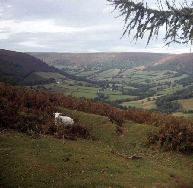
The Vale of Ewyas () is the steep-sided and secluded valley of the River Honddu, in the Black Mountains of Wales and within the Brecon Beacons National Park. As well as its outstanding beauty, it is known for the ruins of Llanthony Priory, and for several noteworthy churches such as those at Capel-y-ffin and Cwmyoy. It is sometimes referred to as the "Llanthony Valley" as Llanthony is the village situated at the valley centre. Geography The Vale is named after the cantref of Ewias, which may have originally been a small Welsh kingdom following the Roman withdrawal from Britain and which, after the Norman conquest of England and Norman invasion of Wales, became an autonomous lordship within the March of Wales. In 1536, the Vale became part of the new county of Monmouthshire, while other parts of Ewyas to the east became incorporated into Herefordshire. At the head of the Vale is the Gospel Pass, which is reputed to have been named after the time in the 12th centu ... [...More Info...] [...Related Items...] OR: [Wikipedia] [Google] [Baidu] |
Crucorney
Crucorney () is a community in the county of Monmouthshire, Wales. It is the northernmost community in the county and covers the villages of Llanvihangel Crucorney, Pandy, Cwmyoy and Llanthony amongst others. The Vale of Ewyas comprises much of the northern part of the community, with the River Honddu running through Llanthony and Llanvihangel Crucorney, before turning northeast passing Pandy towards the River Monnow. The 2011 population was 1,201. Notable landmarks include Llanthony Priory, a Grade I listed former Augustinian priory at Llanthony. Offa's Dyke Path runs along the border between Crucorney and the English county of Herefordshire. The community also has a voluntary group, The Crucorney Environmental Group, which oversees environmental and sustainability issues, including sustainable development, recycling and litter picking. Governance The community elects a community council of eleven councillors. The council meets monthly on the third Tuesday of each month. ... [...More Info...] [...Related Items...] OR: [Wikipedia] [Google] [Baidu] |
Gloucester
Gloucester ( ) is a cathedral city, non-metropolitan district and the county town of Gloucestershire in the South West England, South West of England. Gloucester lies on the River Severn, between the Cotswolds to the east and the Forest of Dean to the west; it is sited from Monmouth, from Bristol, and east of the England and Wales border, border with Wales. Gloucester has a population of around 132,000, including suburban areas. It is a port, linked via the Gloucester and Sharpness Canal to the Severn Estuary. Gloucester was founded by the Roman Empire, Romans and became an important city and ''Colonia (Roman), colony'' in AD 97, under Nerva, Emperor Nerva as ''Glevum, Colonia Glevum Nervensis''. It was granted its first charter in 1155 by Henry II of England, Henry II. In 1216, Henry III of England, Henry III, aged only nine years, was crowned with a gilded iron ring in the Chapter House of Gloucester Cathedral. Gloucester's significance in the Middle Ages is unde ... [...More Info...] [...Related Items...] OR: [Wikipedia] [Google] [Baidu] |
Black Mountains, Wales
The Black Mountains ( or sometimes ) are a group of hills on the England–Wales border. The Welsh part is larger and located in south-east Powys and north-west Monmouthshire, and the smaller English part is in western Herefordshire. The range may be roughly defined as those hills contained within a triangle defined by the towns of Abergavenny in the southeast, Hay-on-Wye in the north and the village of Llangors in the west. Other gateway towns to the Black Mountains include Talgarth and Crickhowell. The Welsh part of the Black Mountains is the easternmost of the four ranges of hills that comprise the Brecon Beacons National Park; they should not be confused with the westernmost, the similarly-named Black Mountain (range), Wales, Black Mountain. The range of hills is well known to walkers and ramblers for the ease of access and views from the many ridge trails, such as that on the Black Hill (Herefordshire), Black Hill in Herefordshire, at the eastern edge of the massif. Gospe ... [...More Info...] [...Related Items...] OR: [Wikipedia] [Google] [Baidu] |
Reg Gammon
Reginald William Gammon (9 January 1894 – 22 April 1997) was an English painter and illustrator. Biography Gammon was born in Petersfield, Hampshire, on 9 January 1894 and educated at Churcher's College there. His father was a builder. Career From 1911, he was apprenticed to the illustrator Frank Patterson, at the latter's Billingshurst, West Sussex studio. He was discharged on medical grounds after enlisting during World War I, but re-enlisted with the Army Service Corps for the final two years of the war. He married Betty Knight (died 1982) in 1917. After the war, they lived in Fernhurst, Sussex, and had two sons. Gammon declined a 1918 offer, made at the instigation of Scottish etcher Muirhead Bone, of a place at the Slade School of Fine Art, but nonetheless had a successful career as a freelance illustrator and writer. For 60 years he wrote and illustrated a feature column for the Cyclists Touring Club's Gazette. The dropping of another column, "In the Ope ... [...More Info...] [...Related Items...] OR: [Wikipedia] [Google] [Baidu] |
Llanvihangel Crucorney
Llanvihangel Crucorney () is a small village in the community (parish) of Crucorney, Monmouthshire, Wales. It is located north of Abergavenny and southwest of Hereford, England on the A465 road. Setting Llanvihangel Crucorney lies on the eastern edge of the Black Mountains in the Brecon Beacons National Park. The village sits at the entrance to the Vale of Ewyas (also known as the Llanthony Valley). The sweeping hill the village sits on is a terminal moraine, deposited during the last Ice Age, that marks the maximum advance of a glacier that once flowed down the valley. The Skirrid is located just to the south; its distinctive peak forms an imposing local landmark. The village is surrounded by farmland with a mix of pasture, for sheep and dairy cattle grazing, and arable crops. The area is popular with hill walkers and the long-distance trails of the Beacons Way and Offa's Dyke Path pass close by. History, amenities and architecture Amenities In the centre of the village ... [...More Info...] [...Related Items...] OR: [Wikipedia] [Google] [Baidu] |
Offa's Dyke Path
Offa's Dyke Path () is a long-distance footpath loosely following the Wales–England border. Officially opened on 10 July 1971, by John Hunt, Baron Hunt, Lord Hunt, it is one of Britain's National Trails and draws hillwalking, walkers from throughout the world. About of the route either follows, or keeps close company with, the remnants of Offa's Dyke, an Earthworks (engineering), earthwork traditionally thought to have been constructed in the late 8th century on the orders of Offa of Mercia, King Offa of Mercia. Walking trail Traveling south to north, starting by the Severn Estuary at Sedbury, near Chepstow, and finishing at Prestatyn on the north coast, the walk will take an average walker roughly 12 days to complete. Roughly following the border in parts, and elsewhere the ancient monument of Offa's Dyke, as well as natural features such as the Hatterrall Ridge, the Dyke Path passes through a variety of landscapes. The route traces the eastern edge of the Black Mountai ... [...More Info...] [...Related Items...] OR: [Wikipedia] [Google] [Baidu] |
Abergavenny
Abergavenny (; , , archaically , ) is a market town and Community (Wales), community in Monmouthshire, Wales. Abergavenny is promoted as a "Gateway to Wales"; it is approximately from the England–Wales border, border with England and is located where the A40 road, A40 trunk road and the recently upgraded A465 road, A465 Heads of the Valleys road meet. Originally the site of a Castra, Roman fort, Gobannium, it became a Middle Ages, medieval Defensive wall, walled town within the Welsh Marches. The town contains the remains of a medieval stone castle built soon after the Norman invasion of Wales, Norman conquest of Wales. Abergavenny is situated at the confluence of the River Usk and a tributary stream, the Gavenny. It is almost entirely surrounded by mountains and hills: the Blorenge (), the Sugar Loaf, Monmouthshire, Sugar Loaf (), Skirrid Fawr (Great Skirrid), Ysgyryd Fach (Little Skirrid), Deri, Rholben and Mynydd Llanwenarth, known locally as "Llanwenarth Breast". Abergav ... [...More Info...] [...Related Items...] OR: [Wikipedia] [Google] [Baidu] |
Brecon Beacons National Park
Brecon Beacons National Park, officially named Bannau Brycheiniog National Park (), is a National parks of the United Kingdom, national park in Wales. It is named after the Brecon Beacons (), the mountain range at its centre. The national park includes the highest mountain in South Wales, Pen y Fan, which has an elevation of . The national park has a total area of . The Brecon Beacons and Fforest Fawr uplands form the central section of the park. To the east are the Black Mountains, Wales, Black Mountains, which extend beyond the national park boundary into England, and to the west is the similarly named but distinct Black Mountain (range), Black Mountain range. These ranges share much of the same basic geology, the southerly dip of the rock strata leading to north-facing escarpments. The highest peak of the Black Mountains is Waun Fach (), and Fan Brycheiniog () is the highest of the Black Mountain. The park was founded in 1957 and is the third and most recently designated Nat ... [...More Info...] [...Related Items...] OR: [Wikipedia] [Google] [Baidu] |
Monmouthshire
Monmouthshire ( ; ) is a Principal areas of Wales, county in the South East Wales, south east of Wales. It borders Powys to the north; the English counties of Herefordshire and Gloucestershire to the north and east; the Severn Estuary to the south, and Torfaen, Newport, Wales, Newport and Blaenau Gwent to the west. The largest town is Abergavenny, and the administrative centre is Usk. The county is administered by Monmouthshire County Council. It sends two directly-elected members to the Senedd at Cardiff and one elected member to the Parliament of the United Kingdom, UK parliament at Westminster. The county name is identical to that of the Monmouthshire (historic), historic county, of which the current local authority covers the eastern three-fifths. Between 1974 and 1996, the county was known as Gwent (county), Gwent, recalling Kingdom of Gwent, the medieval kingdom which covered a similar area. The present county was formed under the Local Government (Wales) Act 1994, which ... [...More Info...] [...Related Items...] OR: [Wikipedia] [Google] [Baidu] |
Listed Building
In the United Kingdom, a listed building is a structure of particular architectural or historic interest deserving of special protection. Such buildings are placed on one of the four statutory lists maintained by Historic England in England, Historic Environment Scotland in Scotland, in Wales, and the Historic Environment Division of the Department for Communities in Northern Ireland. The classification schemes differ between England and Wales, Scotland, and Northern Ireland (see sections below). The term has also been used in the Republic of Ireland, where buildings are protected under the Planning and Development Act 2000, although the statutory term in Ireland is "Record of Protected Structures, protected structure". A listed building may not be demolished, extended, or altered without permission from the local planning authority, which typically consults the relevant central government agency. In England and Wales, a national amenity society must be notified of any work to ... [...More Info...] [...Related Items...] OR: [Wikipedia] [Google] [Baidu] |


