|
Llanerchydol
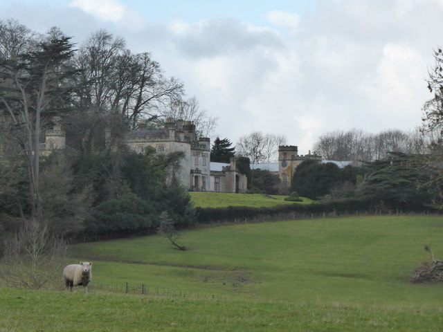
Llanerchydol is a hamlet in Powys, Wales, situated on the A458 about 2 km west of the centre of Welshpool. It is part of the community of Welshpool and also lends its name to an electoral ward of Welshpool Llanerchyddol. Llanerchydol Hall Llanerchydol Hall is located in parkland between the A458 to Llanfair Caereinion and A490 to Llanfyllin. The hall, a largely intact early 19th-century picturesque Gothic Revival house, is a Grade II* listed building, and its well preserved park and gardens are listed, also at Grade II*, on the Cadw/ICOMOS Register of Parks and Gardens of Special Historic Interest in Wales. The site has a long history of occupation, including a Tudor house which burnt down in about 1776, after which David Pugh, a local man who made a fortune selling tea in London, bought the site and built a new house which became known as Llanerchydol Hall. David Pugh's great-grandnephew, also named David Pugh, inherited Llanerchydol Hall and became a local politici ... [...More Info...] [...Related Items...] OR: [Wikipedia] [Google] [Baidu] |
Ystlyg
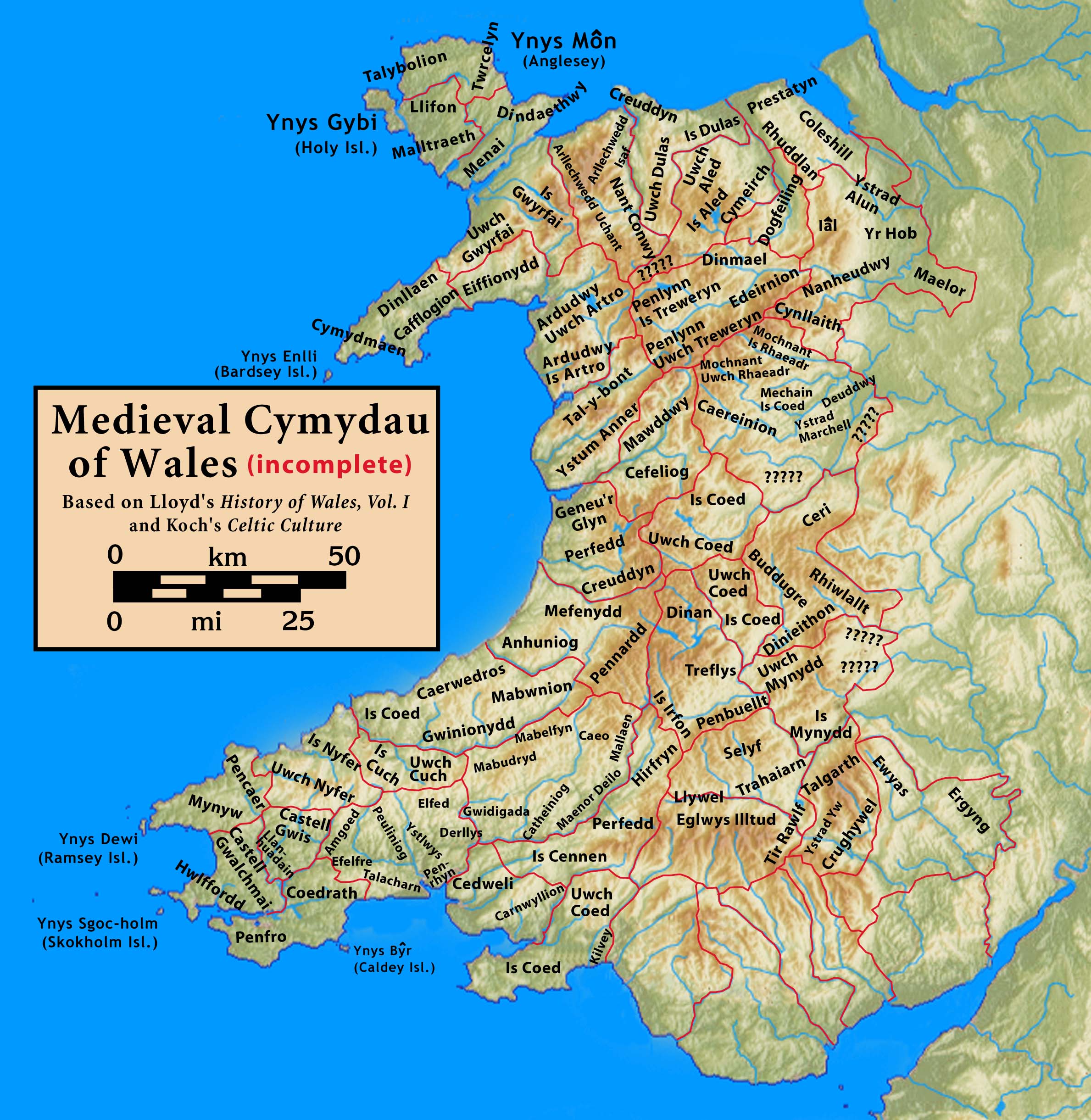
Ystlyg () was a medieval cantref in the Kingdom of Powys. It lay at the east of the kingdom on the border with England. It consisted of the commotes (''cymydau'') of Deuddwr in the north, Ystrad Marchell in the centre, Llannerch Hudol (also written Llannerchwdwl, Llanerchydol or Llannerchudol) in the south, and Y Gorddwr (or Corddwr) in the east beyond the River Severn and Offa's Dyke. Ystad Marchell, Llannerch Hudol and Deuddwr formed the ''Teirswydd'' (English: three ommotes(literally, swydd is ''post'' as in an office)) which were among the lands restored into the possession of Gruffydd ap Gwenwynwyn in return for his homage and fealty by Llywelyn ap Gruffudd at Ystumanner in 1263. Y Gorddwr had remained under the control of the Corbet family (barons of Caus) and therefore the English king. The cantref of Ystlyg (excluding Y Gorddwr) corresponds to the later hundred 100 or one hundred (Roman numerals, Roman numeral: C) is the natural number following 99 (number), 99 ... [...More Info...] [...Related Items...] OR: [Wikipedia] [Google] [Baidu] |
Caereinion
Caereinion (fort of Einion) was a medieval cantref in the Kingdom of Powys, or possibly it was a commote (''cwmwd'') within a cantref called Llŷs Wynaf. It was divided into the manors of Uwch Coed and Is Coed. It lay towards the south of the kingdom, bordering with the commote of Mochnant Uwch Rhaeadr of the cantref of Mochnant and the cantref of Mechain to the north, the commotes of Ystrad Marchell and Llanerch Hudol in the cantref of Ystlyg to the east, the cantrefi of Cedewain to the south and Cyfeiliog to the west. It roughly corresponds to the later hundred of Mathrafal. Castle Caereinion, Caereinion Fechan, Llanfair Caereinion, Llanerfyl, Llangadfan, Llangyniew and part of Berriew Berriew () is a village and Community (Wales), community in Montgomeryshire, Powys, Wales. It is on the Montgomeryshire Canal and the Afon Rhiw, near the confluence (Welsh: ''aber'') with the River Severn (Welsh language, Welsh: Hafren, Afon Hafr ... are within the territory of this ... [...More Info...] [...Related Items...] OR: [Wikipedia] [Google] [Baidu] |
Welshpool Llanerchyddol
Welshpool Llanerchyddol (usually referred to as Llanerchyddol) is the name of an electoral ward in the town of Welshpool, Powys, Wales. It elects a councillor to Powys County Council. Description The Llanerchyddol ward covers the area of the town to the west of Welshpool town centre and the smaller rural settlements of Llanerchydol, Groespluan and Frochas. Llanerchyddol is divided from the Welshpool Castle ward by the A458 road, is bordered to the east by Welshpool Gungrog and to the north and west by Guilsfield. The ward elected two councillors to Montgomeryshire District Council and Powys County Council, but since the May 1999 election it has elected one county councillor to Powys County Council. It is also a community ward and is represented by up to six town councillors on Welshpool Town Council. According to the 2011 UK Census the population of the ward was 2,300. County elections Independent county councillor Graham Breeze (former editor of the ''Powys County Times'') ... [...More Info...] [...Related Items...] OR: [Wikipedia] [Google] [Baidu] |
Ystrad Marchell
; sometimes ''Strad Marchell'') was a medieval commote () in the cantref of Ystlyg in the Kingdom of Powys. It roughly coincides with the parish of Welshpool. It lay at the east of the kingdom, bordering the cantref of Caereinion to the west and south, and the cantref of Mechain to the north-west. Within Ystlyg the other commotes were Deuddwr to the north, Llannerch Hudol to the south and Y Gorddwr (or Corddwr) to the east. The cantref of Ystlyg (excluding Y Gorddwr) corresponds to the later hundred of Deuddwr. Ystrad Marchell was founded by or named for Marchell, a sister of the fifth or sixth century saint Tyfrydog. She was also a saint and is associated with Capel Marchell near Llanrwst, and Ffynnon Farchell () and St Marcella's Church, in Eglwys Wen near Denbigh. The valley of Ystrad Marchell is the site of the medieval Cistercian monastery of Strata Marcella (Latinised form of ''Ystrad Marchell'', strata meaning ''paved road'' or ''causeway'') which was founded in ... [...More Info...] [...Related Items...] OR: [Wikipedia] [Google] [Baidu] |
Commote
A commote (, sometimes spelt in older documents as , plural , less frequently )'' Geiriadur Prifysgol Cymru'' (University of Wales Dictionary), p. 643 was a secular division of land in Medieval Wales. The word derives from the prefix ("together", "with") and the noun ("home, abode"). The English word "commote" is derived from the Middle Welsh . The basic unit of land was the , a small basic village or settlement. In theory, 100 made up a (literally, "one hundred settlements"; plural: ), and half or a third of a was a , although in practice the actual numbers varied greatly. Together with the , commotes were the geographical divisions through which defence and justice were organised. In charge of a commote would be a chieftain probably related to the ruling Prince of the Kingdom. His court would have been situated in a special , referred to as a . Here, the bonded villagers who farmed the chieftain's estate lived, together with the court officials and servants. Commotes were f ... [...More Info...] [...Related Items...] OR: [Wikipedia] [Google] [Baidu] |
Welshpool
Welshpool ( ) is a market town and Community (Wales), community in Powys, Wales, historically in the Historic counties of Wales, county of Montgomeryshire. The town is from the Wales–England border and low-lying on the River Severn. The community, which also includes Cloddiau and Pool Quay, has a population of 6,664 (as of the 2011 United Kingdom census), with the town having 5,948. There are many examples of Georgian architecture within the town. Powis Castle is located to the north. Toponym ''Y Trallwng'' is the Welsh language name of the town. It means "the marshy or sinking land". In English language, English it was initially known as Pool but its name was changed to Welshpool in 1835 to distinguish it from the English town of Poole in Dorset. History St Cynfelin is reputed to be the founder of two churches in the town, St Mary's and St Cynfelin's, during the Age of the Saints in the 5th and 6th centuries. The parish of Welshpool roughly coincides with the medieval ... [...More Info...] [...Related Items...] OR: [Wikipedia] [Google] [Baidu] |
Wales
Wales ( ) is a Countries of the United Kingdom, country that is part of the United Kingdom. It is bordered by the Irish Sea to the north and west, England to the England–Wales border, east, the Bristol Channel to the south, and the Celtic Sea to the south-west. , it had a population of 3.2 million. It has a total area of and over of Coastline of Wales, coastline. It is largely mountainous with its higher peaks in the north and central areas, including Snowdon (), its highest summit. The country lies within the Temperate climate, north temperate zone and has a changeable, Oceanic climate, maritime climate. Its capital and largest city is Cardiff. A distinct Culture of Wales, Welsh culture emerged among the Celtic Britons after the End of Roman rule in Britain, Roman withdrawal from Britain in the 5th century, and Wales was briefly united under Gruffudd ap Llywelyn in 1055. After over 200 years of war, the Conquest of Wales by Edward I, conquest of Wales by King Edward I o ... [...More Info...] [...Related Items...] OR: [Wikipedia] [Google] [Baidu] |
Powys Wenwynwyn
Powys Wenwynwyn or Powys Cyfeiliog was a Welsh kingdom which existed during the high Middle Ages. The realm was the southern portion of the former princely state of Kingdom of Powys, Powys which split following the death of Madog ap Maredudd of Powys in 1160: the northern portion (Maelor) went to Gruffydd Maelor and eventually became known as Powys Fadog; while the southern portion (Cyfeiliog) going to Owain Cyfeiliog and becoming known, eventually, as Powys Wenwynwyn after Prince Gwenwynwyn ab Owain, its second ruler. Powys Wenwynwyn and Kingdom of Gwynedd, Gwynedd became bitter rivals in the years that followed, with the former frequently allying itself with England to further its aims of weakening the latter. Princes of Powys Wenwynwyn * 1160–1195 Owain Cyfeiliog married a daughter of Owain Gwynedd and abdicated in 1195. * 1195–1216 Gwenwynwyn ab Owain Gwenwynwyn seized the cantref of Arwystli in 1197, when he was aligned with England. Following the marriage of Llywely ... [...More Info...] [...Related Items...] OR: [Wikipedia] [Google] [Baidu] |
Madog Ap Maredudd
Madog ap Maredudd (, ; died 1160) was the last prince of the entire Kingdom of Powys, Wales. He held for a time, the FitzAlan Lordship of Oswestry, family of the Earl of Arundel, Earls of Arundel, of Arundel Castle. His daughter married Lord Rhys, prince of Wales. Early life Madog was the son of King Maredudd ap Bleddyn and grandson of King Bleddyn ap Cynfyn. He followed his father on the throne of Powys in 1132. He is recorded as taking part in the Battle of Lincoln (1141), Battle of Lincoln in 1141 in support of Ranulf de Gernon, 4th Earl of Chester, along with Owain Gwynedd's brother Cadwaladr ap Gruffydd and a large army of Welshmen. In 1149 he is recorded giving the commote of Cyfeiliog to his nephews Owain Cyfeiliog and Meurig. The same year Madog was able to rebuild Oswestry Castle, a fortress of William Fitzalan (rebel), William Fitzalan. It would seem likely that he had gained both the fortresses of Oswestry and Whittington Castle, Whittington in 1146 of Fitzalan, the ... [...More Info...] [...Related Items...] OR: [Wikipedia] [Google] [Baidu] |
Marcher Lord
A marcher lord () was a noble appointed by the king of England to guard the border (known as the Welsh Marches) between England and Wales. A marcher lord was the English equivalent of a margrave (in the Holy Roman Empire) or a marquis (in France) before the introduction of the title of "marquess" in Britain; no marcher lord ever bore the rank of marquess. In this context, the word ''march'' means a border region or frontier, and is cognate with the verb "to march", both ultimately derived from Proto-Indo-European ''*mereg-'', "edge" or "boundary". The greatest marcher lords included the earls of Chester, Gloucester, Hereford, Pembroke and Shrewsbury (see also English earls of March). County palatine Some strong earldoms along the Welsh border were granted the privileged status of county palatine shortly after the Norman Conquest, but only that based on Chester survived for a long period. The term particularly applies to Anglo-Norman lords in Wales, who had complete ... [...More Info...] [...Related Items...] OR: [Wikipedia] [Google] [Baidu] |
Berriew
Berriew () is a village and Community (Wales), community in Montgomeryshire, Powys, Wales. It is on the Montgomeryshire Canal and the Afon Rhiw, near the confluence (Welsh: ''aber'') with the River Severn (Welsh language, Welsh: Hafren, Afon Hafren) at , 79 miles (128 km) from Cardiff and 151 miles (243 km) from London. The village itself had a population of 283. and the community also includes Garthmyl Hall, Berriew, Garthmyl Hall and Refail. Buildings and architecture Berriew contains many architecturally important buildings. There are 103 Listed Buildings in Berriew of which 5 are Grade II*. Nearly a quarter of the listed building are connected with the Montgomeryshire Canal which runs across the parish to the S.E. of Berriew. The most important of the listed buildings are Vaynor, which is probably the earliest brick built house of the mid-17th. century still standing in Montgomeryshire, and Glansevern, designed by the notable Shrewsbury architect Joseph Bromfield ... [...More Info...] [...Related Items...] OR: [Wikipedia] [Google] [Baidu] |
Cedewain
Cedewain (or Cydewain) was a medieval cantref in the Kingdom of Powys. It possibly consisted of the commotes (''cymydau'') of Cynan, Hafren and Uwch Hanes. Other sources give the commotes as Cedewain, Eginlle and Ceri. It lay at the south of the kingdom, bordering with the cantrefi of Caereinion and Ystlyg to the north across the river Rhiw, and the cantrefi of Arwystli (subject to disputes between Powys and Gwynedd) and Maelienydd (originally an independent kingdom) to the south. Its easterly border, which was the River Severn, faced England. Bettws Cedewain takes its name from the cantref. The lords of Cedewain resided at Dolforwyn Castle. Maredudd ap Rhobert was Lord of Cedewain and Chief Counsellor of Wales when he died in 1244 after joining the religious order at Strata Florida Abbey. Knighton was attacked by 'the lords of Ceri and Cydewain' in 1260, but the following year saw the death of Owain ap Maredudd, Lord of Cydewain, nephew of Maredudd ap Rhobert. In early 1278 ... [...More Info...] [...Related Items...] OR: [Wikipedia] [Google] [Baidu] |


