|
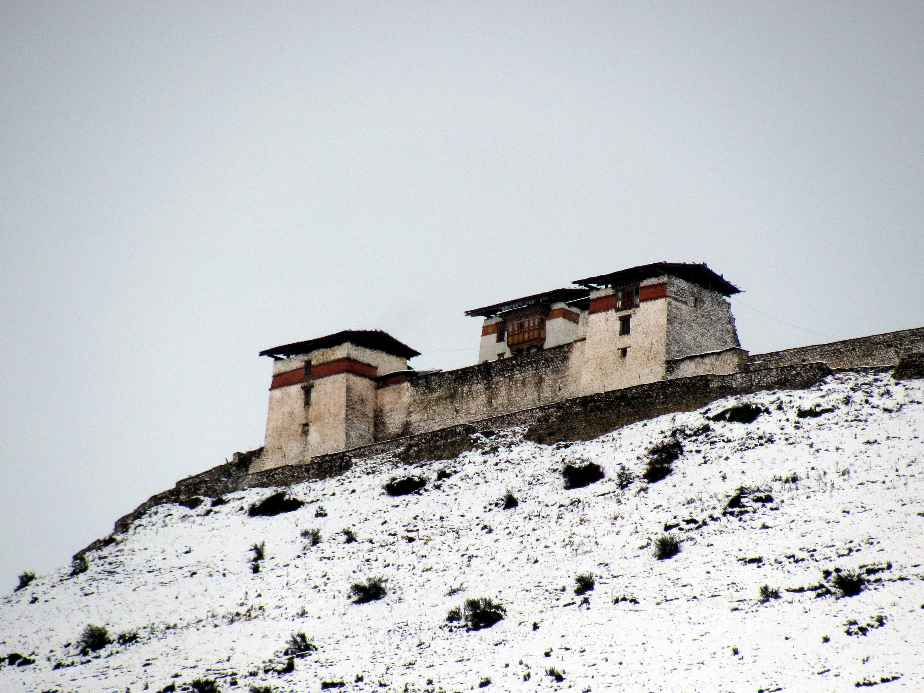
Lingzhi Yügyal Dzong
Lingzhi Yügyal Dzong, is an important Drukpa Kagyu monastery and administrative center situated at an altitude of 4150 metres in Lingzhi, Thimphu District, Bhutan. There are about thirty monks headed by a Lama Neten (head of a district monastic body) resident in the Dzong. The office of the Drungpa (sub-district administrator) is also housed in the Dzong. History The Dzong was built in 1668 by the third Desi of Bhutan, Chögyal Minjur Tenpa (r. 1667-1680) to commemorate victory over a Tibetan invasion and named Yügyal Dzong. It controlled the border between Tibet and Bhutan and was one of the main defensive fortresses in the north of Bhutan. The Dzong was partly damaged by an earthquake in 1867. In the 1950s the building was reconstructed and used as administrative centre. Renovation work on the Dzong began in 2005 and was still ongoing in 2010. See also * Geography of Bhutan * Religion in Bhutan * Transport in Bhutan Transport in Bhutan uses about of roads and four ai ... [...More Info...] [...Related Items...] OR: [Wikipedia] [Google] [Baidu] |
Lingzhi Yugyal Dzong 01
Lingzhi may refer to: * Lingzhi mushroom (''Ganoderma lingzhi''), also called reishi, or several other similar mushrooms of the genus ''Ganoderma'' including: ** ''Ganoderma lucidum'' ** ''Ganoderma tsugae'' * Lingzhi Gewog, a village block (gewog) of Thimphu District, Bhutan * Lingzhi Yügyal Dzong Lingzhi Yügyal Dzong, is an important Drukpa Kagyu monastery and administrative center situated at an altitude of 4150 metres in Lingzhi, Thimphu District, Bhutan. There are about thirty monks headed by a Lama Neten (head of a district monastic ..., a monastery and fortress in Bhutan * Lingzhi Township, in Jingning County, Gansu, China * Lingzhi Subdistrict, in Yuecheng District, Shaoxing, Zhejiang, China * Lingzhi station of the Shenzhen Metro, Shenzhen, Guangdong, China * Forthing Lingzhi, minivans produced by Dongfeng Liuzhou Motor {{disambiguation, geo th:เห็ดหลินจือ ... [...More Info...] [...Related Items...] OR: [Wikipedia] [Google] [Baidu] |
Drukpa Kagyu
The Drukpa Kagyu (), or simply Drukpa, sometimes called either Dugpa or " Red Hat sect" in older sources,Initiations And Initiates In Tibet, p. 34 by . lineage is a branch of the school of Tibetan Buddhism. The Kagyu school is one of the [...More Info...] [...Related Items...] OR: [Wikipedia] [Google] [Baidu] |
Thimphu District
Thimphu District ( Dzongkha: ཐིམ་ཕུ་རྫོང་ཁག་; Wylie: ''Thim-phu rdzong-khag'') is a dzongkhag (district) of Bhutan. Thimphu is also the capital of Bhutan and the largest city in the whole kingdom. Languages The dominant language throughout the district is Dzongkha; however, within the capital nearly every language of Bhutan may be encountered. Administrative divisions Thimphu District is divided into eight '' gewogs'' and one town (Thimphu): *Chang Gewog *Dagala Gewog *Genyekha Gewog *Kawang Gewog *Lingzhi Gewog *Mewang Gewog *Naro Gewog *Soe Gewog Lingzhi, Soe and Naro Gewogs belong to the Lingzhi ''Dungkhag'' subdistrict, the only subdistrict within Thimphu District. The remaining gewogs do not belong to any subdistrict. Environment The northern half of Thimphu District (the ''gewogs'' of Kawang, Lingzhi, Naro and Soe – corresponding roughly to Lingzhi Dungkhag) is subject to environmental protection, falling within Jigme Dorji Na ... [...More Info...] [...Related Items...] OR: [Wikipedia] [Google] [Baidu] |
Bhutan
Bhutan (; dz, འབྲུག་ཡུལ་, Druk Yul ), officially the Kingdom of Bhutan,), is a landlocked country in South Asia. It is situated in the Eastern Himalayas, between China in the north and India in the south. A mountainous country, Bhutan is known as "Druk Yul," or "Land of the Thunder Dragon". Nepal and Bangladesh are located near Bhutan but do not share a land border. The country has a population of over 727,145 and territory of and ranks 133rd in terms of land area and 160th in population. Bhutan is a Constitutional Democratic Monarchy with King as head of state and Prime Minister as head of government. Mahayana and Vajrayana Buddhism is the state religion and the Je Khenpo is the head of state religion. The subalpine Himalayan mountains in the north rise from the country's lush subtropical plains in the south. In the Bhutanese Himalayas, there are peaks higher than above sea level. Gangkhar Puensum is Bhutan's highest peak and is the high ... [...More Info...] [...Related Items...] OR: [Wikipedia] [Google] [Baidu] |
Dzong
Dzong architecture is used for dzongs, a distinctive type of fortified monastery ( dz, རྫོང, , ) architecture found mainly in Bhutan and Tibet. The architecture is massive in style with towering exterior walls surrounding a complex of courtyards, temples, administrative offices, and monks' accommodation. Characteristics Distinctive features include: * High inward sloping walls of brick and stone painted white with few or no windows in the lower sections of the wall * Use of a surrounding red ochre stripe near the top of the walls, sometimes punctuated by large gold circles * Use of unique style flared roofs atop interior temples * Massive entry doors made of wood and iron * Interior courtyards and temples brightly colored in Buddhist-themed art motifs such as the ashtamangala or swastika Regional differences Bhutan Dzongs serve as the religious, military, administrative, and social centers of their district. They are often the site of an annual '' tsechu'' or religio ... [...More Info...] [...Related Items...] OR: [Wikipedia] [Google] [Baidu] |
Geography Of Bhutan
The Kingdom of Bhutan is a sovereign nation, located towards the eastern extreme of the Himalayas mountain range. It is fairly evenly sandwiched between the sovereign territory of two nations: first, the People's Republic of China on the north and northwest. There are approximately 477 kilometres of border with that nation's Tibet Autonomous Region. The second nation is the Republic of India on the south, southwest, and east; there are approximately 659 kilometres with the states of Arunachal Pradesh, Assam, West Bengal, and Sikkim, in clockwise order from the kingdom. Bhutan's total borders amount to 1,139 kilometres. The Republic of Nepal to the west, the India to the south, and the Union of Myanmar to the southeast are other close neighbours; the former two are separated by only very small stretches of Indian territory. Bhutan is a very compact nation, but with just a small bit more length than width. The nation's territory totals an approximate 38,394 square kilometres. Bec ... [...More Info...] [...Related Items...] OR: [Wikipedia] [Google] [Baidu] |
Religion In Bhutan
The official religion in Bhutan is Vajrayana Buddhism, which is practiced by almost 85% of the population. Bhutan is a Buddhist country by constitution and Buddhism plays a vital role in the country. Buddhism is the cultural heritage of Bhutan and its people's identity as well. Freedom of religion is guaranteed by the King. Approximately 85 percent of the population of 770,000 follow either the Drukpa Lineage of the Kagyu school, the Nyingma school of Tibetan Buddhism or another school of Buddhism. Almost 12 percent (11.3 percent ), mainly Lhotshampas, practice Hinduism.Pew Research Center's Religion & Public Life Project: Bhutan |
Transport In Bhutan
Transport in Bhutan uses about of roads and four airports, three of which are operational and interconnected. Paro Airport is the only airport which accommodates international flights. As part of Bhutan's infrastructure modernization programs, its road system has been under development since the 1960s. There are no railways (although one is planned) and, since Bhutan is a landlocked country without major waterways, there are no ports. Road Bhutan had a total of of roads in 2003, of which were paved and unpaved. Because of the lack of paved roads, travel in Bhutan was by foot or on mule- or horseback until 1961; the trip from the Indian border to Thimphu took six days. Road construction began in earnest during the First Development Plan (1961–66). The first paved road was completed in 1962. A branch road later linked Paro with the Phuntsholing–Thimphu road, and a jeep track linked Thimphu and Phuntsholing with Jaigaon, West Bengal. Travel time by motor vehicle from ... [...More Info...] [...Related Items...] OR: [Wikipedia] [Google] [Baidu] |


