|
Lexington Tower
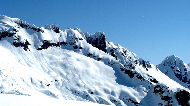
Lexington Tower is a granite pinnacle located in the North Cascades, approximately one mile south of Washington Pass along the North Cascades Highway. It is set within the Okanogan–Wenatchee National Forest, on the shared border of Okanogan County and Chelan County in the state of Washington. Lexington Tower is part of the iconic Liberty Bell Group, a group of spires which also includes Liberty Bell Mountain, Concord Tower, and the Early Winters Spires. Precipitation runoff from Lexington Tower drains west into State Creek and east into Early Winters Creek. Topographic relief is significant as the summit rises above Early Winters Creek in approximately one-half mile. Climbing routes The first ascent was made July 5, 1954, by Tim Kelley and Dick McGowan via the North Face. Rock climbing routes on Lexington Tower: * North Face - - Tim Kelley, Dick McGowan (1954) * South Face - - Donald Anderson, Larry Scott (1964) * East Face - class 5.9+ - Steve Marts, Donald McPhe ... [...More Info...] [...Related Items...] OR: [Wikipedia] [Google] [Baidu] |
Early Winters Spires
The Early Winters Spires are two rock formations in the Liberty Bell Group of the North Cascade Range, set between Liberty Bell Mountain and Blue Lake Peak in Washington state, United States. The two spires (North and South) are virtually one granite massif, split by a deep cleft formed by jointing and erosion. The shapes of these spires are attributed to ice wedging, cleaving along master joints by soil acids, and perpetual weathering. North Early Winters Spire Elevation: 7,760 ft / 2,366 m First ascent: May 28, 1950. Wesley Grande, Pete Schoening, and Dick Widrig. South Early Winters Spire Elevation: 7,807 ft / 2,380 m First ascent: July 20, 1937. Kenneth Adam, Raffi Bedayn, and W. Kenneth Davis were credited in their report of first ascent however, only Bedayn and Neil Ruge appear in the summit register. Climate Early Winters Spires are located in the marine west coast climate zone of western North America. Most weather fronts originate in the Pacific ... [...More Info...] [...Related Items...] OR: [Wikipedia] [Google] [Baidu] |
Cascade Alpine Guide
Friedrich Wolfgang Beckey (14 January 1923 – 30 October 2017), known as Fred Beckey, was an American rock climber, mountaineer and book author, who in seven decades of climbing achieved hundreds of first ascents of some of the tallest peaks and most important routes throughout Alaska, the Canadian Rockies and the Pacific Northwest. Among the Fifty Classic Climbs of North America, seven were established by Beckey, often climbing with some of the best known climbers of each generation. Early years Beckey was born in 1923 near Düsseldorf, Germany to Klaus Beckey, a surgeon, and Marta Maria Beckey who was an opera singer. In 1925 economic hardships due to hyperinflation in the Weimar Republic forced his family to emigrate to the United States, settling in Seattle, Washington (state), Washington. His brother, Helmut "Helmy" Beckey, was born in Seattle in 1926 and would later become Fred's frequent climbing partner. At age twelve, Fred Beckey climbed Boulder Peak in the Cascades by ... [...More Info...] [...Related Items...] OR: [Wikipedia] [Google] [Baidu] |
Oceanic Lithosphere
A lithosphere () is the rigid, outermost rocky shell of a terrestrial planet or natural satellite. On Earth, it is composed of the crust and the lithospheric mantle, the topmost portion of the upper mantle that behaves elastically on time scales of up to thousands of years or more. The crust and upper mantle are distinguished on the basis of chemistry and mineralogy. Earth's lithosphere Earth's lithosphere, which constitutes the hard and rigid outer vertical layer of the Earth, includes the crust and the lithospheric mantle (or mantle lithosphere), the uppermost part of the mantle that is not convecting. The layer below the lithosphere is called the asthenosphere, which is the weaker, hotter, and deeper part of the upper mantle that is able to convect. The lithosphere–asthenosphere boundary is defined by a difference in response to stress. The lithosphere remains rigid for very long periods of geologic time in which it deforms elastically and through brittle failure ... [...More Info...] [...Related Items...] OR: [Wikipedia] [Google] [Baidu] |
Volcano
A volcano is commonly defined as a vent or fissure in the crust of a planetary-mass object, such as Earth, that allows hot lava, volcanic ash, and gases to escape from a magma chamber below the surface. On Earth, volcanoes are most often found where tectonic plates are diverging or converging, and because most of Earth's plate boundaries are underwater, most volcanoes are found underwater. For example, a mid-ocean ridge, such as the Mid-Atlantic Ridge, has volcanoes caused by divergent tectonic plates whereas the Pacific Ring of Fire has volcanoes caused by convergent tectonic plates. Volcanoes resulting from divergent tectonic activity are usually non-explosive whereas those resulting from convergent tectonic activity cause violent eruptions."Mid-ocean ridge tectonics, volcanism and geomorphology." Geology 26, no. 455 (2001): 458. https://macdonald.faculty.geol.ucsb.edu/papers/Macdonald%20Mid-Ocean%20Ridge%20Tectonics.pdf Volcanoes can also form where there is str ... [...More Info...] [...Related Items...] OR: [Wikipedia] [Google] [Baidu] |
Eocene
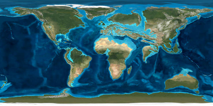
The Eocene ( ) is a geological epoch (geology), epoch that lasted from about 56 to 33.9 million years ago (Ma). It is the second epoch of the Paleogene Period (geology), Period in the modern Cenozoic Era (geology), Era. The name ''Eocene'' comes from the Ancient Greek (''Ēṓs'', 'Eos, Dawn') and (''kainós'', "new") and refers to the "dawn" of modern ('new') fauna that appeared during the epoch.See: *Letter from William Whewell to Charles Lyell dated 31 January 1831 in: * From p. 55: "The period next antecedent we shall call Eocene, from ήως, aurora, and χαινος, recens, because the extremely small proportion of living species contained in these strata, indicates what may be considered the first commencement, or ''dawn'', of the existing state of the animate creation." The Eocene spans the time from the end of the Paleocene Epoch to the beginning of the Oligocene Epoch. The start of the Eocene is marked by a brief period in which the concentration of the carbon isoto ... [...More Info...] [...Related Items...] OR: [Wikipedia] [Google] [Baidu] |
Glacial Valley
U-shaped valleys, also called trough valleys or glacial troughs, are formed by the process of glaciation. They are characteristic of mountain glaciation in particular. They have a characteristic U shape in cross-section, with steep, straight sides and a flat or rounded bottom (by contrast, valleys carved by rivers tend to be V-shaped in cross-section). Glaciated valleys are formed when a glacier travels across and down a slope, carving the valley by the action of scouring. When the ice recedes or thaws, the valley remains, often littered with small boulders that were transported within the ice, called glacial till or glacial erratic. Examples of U-shaped valleys are found in mountainous regions throughout the world including the Andes, Alps, Caucasus Mountains, Himalaya, Rocky Mountains, New Zealand and the Scandinavian Mountains. They are found also in other major European mountains including the Carpathian Mountains, the Pyrenees, the Rila and Pirin mountains in Bulgari ... [...More Info...] [...Related Items...] OR: [Wikipedia] [Google] [Baidu] |
Avalanche
An avalanche is a rapid flow of snow down a Grade (slope), slope, such as a hill or mountain. Avalanches can be triggered spontaneously, by factors such as increased precipitation or snowpack weakening, or by external means such as humans, other animals, and earthquakes. Primarily composed of flowing snow and air, large avalanches have the capability to capture and move ice, rocks, and trees. Avalanches occur in two general forms, or combinations thereof: slab avalanches made of tightly packed snow, triggered by a collapse of an underlying weak snow layer, and loose snow avalanches made of looser snow. After being set off, avalanches usually accelerate rapidly and grow in mass and volume as they capture more snow. If an avalanche moves fast enough, some of the snow may mix with the air, forming a powder snow avalanche. Though they appear to share similarities, avalanches are distinct from slush flows, Mudflow, mudslides, Landslide#Debris landslide, rock slides, and serac collap ... [...More Info...] [...Related Items...] OR: [Wikipedia] [Google] [Baidu] |
Oceanic Climate
An oceanic climate, also known as a marine climate or maritime climate, is the temperate climate sub-type in Köppen climate classification, Köppen classification represented as ''Cfb'', typical of west coasts in higher middle latitudes of continents, generally featuring cool to warm summers and cool to mild winters (for their latitude), with a relatively narrow annual temperature range and few extremes of temperature. Oceanic climates can be found in both hemispheres generally between 40 and 60 degrees latitude, with subpolar versions extending to 70 degrees latitude in some coastal areas. Other varieties of climates usually classified together with these include subtropical highland climates, represented as ''Cwb'' or ''Cfb'', and subpolar oceanic or cold subtropical highland climates, represented as ''Cfc'' or ''Cwc''. Subtropical highland climates occur in some mountainous parts of the subtropics or tropics, some of which have monsoon influence, while their cold variants an ... [...More Info...] [...Related Items...] OR: [Wikipedia] [Google] [Baidu] |
Orographic Lift
Orographic lift occurs when an air mass is forced from a low elevation to a higher elevation as it moves over rising terrain. As the air mass gains altitude it quickly cools down adiabatically, which can raise the relative humidity to 100% and create clouds and, under the right conditions, precipitation. Orographic lifting can have a number of effects, including precipitation, rain shadowing, leeward winds, and associated clouds. Precipitation Precipitation induced by orographic lift occurs in many places throughout the world. Examples include: * The Mogollon Rim in central Arizona * The western slope of the Sierra Nevada range in California. * The western slope of the Wasatch Range in Utah. Specifically the Little and Big Cottonwood Canyons. * The mountains near Baja California North – specifically La Bocana to Laguna Hanson. * The windward slopes of Khasi and Jayantia Hills (see Mawsynram) in the state of Meghalaya in India. * The Western Highlands of Yemen, which rece ... [...More Info...] [...Related Items...] OR: [Wikipedia] [Google] [Baidu] |
Cascade Mountains
The Cascade Range or Cascades is a major mountain range of western North America, extending from southern British Columbia through Washington and Oregon to Northern California. It includes both non-volcanic mountains, such as many of those in the North Cascades, and the notable volcanoes known as the High Cascades. The small part of the range in British Columbia is referred to as the Canadian Cascades or, locally, as the Cascade Mountains. The highest peak in the range is Mount Rainier in Washington at . part of the Pacific Ocean's Ring of Fire, the ring of volcanoes and associated mountains around the Pacific Ocean. All of the eruptions in the contiguous United States over the last 200 years have been from the Cascade Volcanoes. The two most recent were Lassen Peak from 1914 to 1921 and a major eruption of Mount St. Helens in 1980. Minor eruptions of Mount St. Helens have also occurred since, most recently from 2004 to 2008. The Cascade Range is a part of the American Cordil ... [...More Info...] [...Related Items...] OR: [Wikipedia] [Google] [Baidu] |


