|
Lavalleja Department
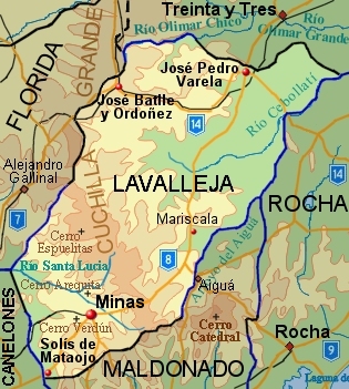
Lavalleja (; ) is a department of Uruguay. Its capital is Minas. It is located in the southeast of the country, bordered to the north by the department of Treinta y Tres to the east with Rocha, to the south with Canelones and Maldonado, and to the west to Florida. The department is named in honor of Brigadier Juan Antonio Lavalleja, who had distinguished military and political action in the country's independence. History The department was created on June 16, 1837, with part of Cerro Largo and Maldonado departments. It was first named as Minas. In March 1888, it was asked that the Chamber of Deputies raised the settlement hierarchy of the village of Minas to be a town and to change the department's name to Lavalleja. The first was approved. From then, and until December 26, 1927, when the name was changed to Lavalleja, widespread debates about the matter were held. There was political will to designate a department under the name of the head of the Liberation Crusade, but ... [...More Info...] [...Related Items...] OR: [Wikipedia] [Google] [Baidu] |
Departments Of Uruguay
Uruguay consists of 19 Department (country subdivision), departments (''departamentos''). Each department has a legislature, called a Departmental Board, and a chief executive called an ''Intendant (government official)#Uruguay, Intendente''. History The first division of Uruguay into six departments occurred on 27 January 1816. In February of the same year, two more departments were formed, and in 1828 one more was added. When the Constitution of Uruguay#Original Constitution (1830 - 1918), country's first constitution was signed in 1830, there were nine departments: Montevideo, Maldonado, Canelones, San José, Colonia, Soriano, Paysandú, Durazno and Cerro Largo. At that time, the department of Paysandú occupied all the territory north of the Río Negro, which included the current departments of Artigas, Rivera, Tacuarembó, Salto, Paysandú and Río Negro. On 17 June 1837, this northern territory was divided in three, by the creation of the departments of Salto and Tacuarem ... [...More Info...] [...Related Items...] OR: [Wikipedia] [Google] [Baidu] |
Thirty-Three Orientals
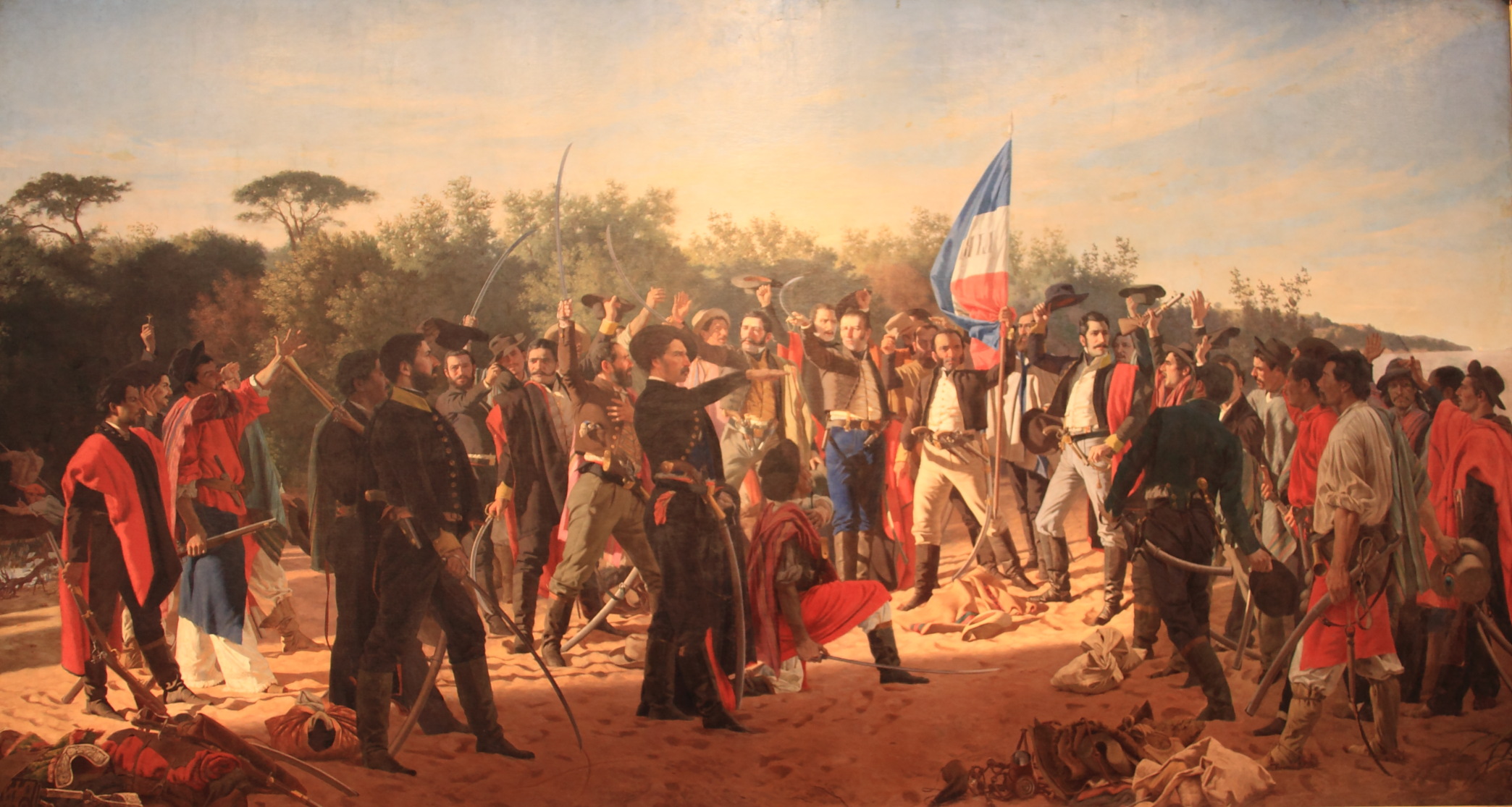
The ''Treinta y Tres Orientales'' (English: Thirty-Three Orientals or Thirty-Three Easterners) was a revolutionary group led by Juan Antonio Lavalleja and Manuel Oribe against the Empire of Brazil. Their actions culminated in the foundation of modern Uruguay. They became famous by the name of the Treinta y Tres Orientales when, in 1825, they began an insurrection for the independence of Banda Oriental, Oriental Province, a historical territory encompassing modern Uruguay and part of modern Brazilian Rio Grande do Sul State, from Brazilian control. The group was also known as the Thirty Three Immortals. Background Between 1816 and 1820, the United Kingdom of Portugal, Brazil and the Algarves invaded and occupied the post-Spanish ''Provincia Oriental''. These Luso-Brazilian forces Portuguese conquest of the Banda Oriental, easily defeated the resistance of the forces of José Gervasio Artigas who, when routed, had to abandon the province in 1820, and went into self-exile in Pa ... [...More Info...] [...Related Items...] OR: [Wikipedia] [Google] [Baidu] |
Indigenous People
There is no generally accepted definition of Indigenous peoples, although in the 21st century the focus has been on self-identification, cultural difference from other groups in a state, a special relationship with their traditional territory, and an experience of subjugation and discrimination under a dominant cultural model. Estimates of the population of Indigenous peoples range from 250 million to 600 million. There are some 5,000 distinct Indigenous peoples spread across every inhabited climate zone and inhabited continent of the world. Most Indigenous peoples are in a minority in the state or traditional territory they inhabit and have experienced domination by other groups, especially non-Indigenous peoples. Although many Indigenous peoples have experienced colonization by settlers from European nations, Indigenous identity is not determined by Western colonization. The rights of Indigenous peoples are outlined in national legislation, treaties and international law ... [...More Info...] [...Related Items...] OR: [Wikipedia] [Google] [Baidu] |
Afro-Uruguayans
Afro-Uruguayans (), also known as Black Uruguayans (), are Uruguayans with partial or total ancestry from any of the Black racial groups of Africa. Afro-Uruguayans are generally considered the second-largest ethnic group in the country, although in much smaller numbers compared to the majority European-descended population, as they make up less than 10% of Uruguay's population. People of African descent first started arriving to Uruguay during Spanish colonization, which imported many as slaves. Following the abolition of slavery in the mid-19th century, Afro-Uruguayans continued to face widespread discrimination. Afro-Uruguayan groups seeking political advancement first began to organize in the 1930s. Throughout the late 20th century and early 21st century, various organizations have arisen to combat racism in Uruguay, and promote Afro-Uruguayan culture. Afro-Uruguayans remain largely economically disadvantaged, and primarily work in the manufacturing, construction, and domes ... [...More Info...] [...Related Items...] OR: [Wikipedia] [Google] [Baidu] |
White Latin Americans
White Latin Americans () are Latin Americans of total or predominantly European diaspora, European or West Asia, West Asian ancestry. Population with majority (or unique) ancestry of European settlers who arrived in Americas, the Americas during the colonial and post-colonial periods can be found throughout Latin America. Most immigrants who settled the region for the past five centuries were Spanish people, Spanish and Portuguese people, Portuguese; after independence, the most numerous non-Iberian Peninsula, Iberian immigrants were French people, French, Italian people, Italians, and Germans, followed by other Europeans as well as West Asians (such as Levantine Arabs and Armenian people, Armenians). Composing from 33% to 36% of the population , according to some sources,Central Intelligence Agency, CIA data from The World Factbook'Field Listing :: Ethnic groupsan retrieved on May 09 2011. They show 191,543,213 whites from a total population of 579,092,570. For a few countries ... [...More Info...] [...Related Items...] OR: [Wikipedia] [Google] [Baidu] |
Cerro Verdún
Cerro is Spanish for "hill" or "mountain". People * Francisco Cerro (born 1988), Argentine footballer * Francisco Cerro Chaves (born 1957), Spanish prelate, theologian, and philosopher of the Catholic Church * Ian Cerro (born 1996), American footballer * Isma Cerro (born 1995), Spanish footballer * Mariana Cerro (born 2000), Spanish footballer * Rafael Cerro (born 1997), Colombian weightlifter * Rafael Cerro (born 1993), Spanish bullfighter * Samuele Cerro (born 1995), Italian triple jumper * Luis del Cerro (1924–2019), Spanish sport shooter, Olympian * María Del Cerro (born 1985), Argentine model, actress, television presenter and fashion designer * Saúl del Cerro (born 2004), Spanish footballer * Luis Miguel Sánchez Cerro (1889–1933), Peruvian army officer and President of Peru Toponyms ;Argentina: * Cerro Ameghino, Mendoza Province *Cerro Archibarca, Salta Province *Cerro Arco, Mendoza Province * Cerro Azul, Misiones *Cerro Bandera Formation, Neuquén Province *Ce ... [...More Info...] [...Related Items...] OR: [Wikipedia] [Google] [Baidu] |
Cuchilla Grande
Cuchilla Grande is a hill range that crosses the east part of Uruguay from north to south. It extends from the south part of Cerro Largo Department, through the departments of Treinta y Tres and Lavalleja and ends in Maldonado Department where it forms its highest peaks. Noted features In the southern part of this range, there is the Cerro Catedral, the highest point of the country. This hill is situated in the Maldonado Department. Also found in this range is the Cerro Pan de Azúcar, likewise situated in the Maldonado Department, near Piriápolis. Secondary ranges * Cuchilla de Mansavillagra * Sierra Carapé * Sierra Aceguá * Sierra de las Ánimas * Cuchilla Grande Inferior * Cuchilla de Cerro Largo See also * Geography of Uruguay External links Cerro Catedral Site of the Municipality of Maldonado, Uruguay Maldonado () is the capital city of Maldonado Department, in eastern Uruguay. According to the 2023 Census, it is the fourth most populated city in the count ... [...More Info...] [...Related Items...] OR: [Wikipedia] [Google] [Baidu] |
Gregorio Aznárez
Gregorio Aznárez is a village in the Maldonado Department of southeastern Uruguay. Geography The village is located on the west of the department, on Route 9 (Uruguay), Route 9, about north of the junction with Ruta Interbalnearia. History Gregorio Aznárez born in Villa Mendigorria (Navarra), Spain is 1860. Descendant of a noble family, he and his family emigrate to Uruguay due to the Third Carlist War. At the age of 28 years Gregorio Aznárez was already involved in different commerce activities: He participated in the first Uruguayan exports to Brazil of flour, cereals and leather. Two years later he made the first tests of rice growing and sugar beet. His connection with the sugar industry dates back to 1891, when he met the engineer Luis Torrosella, which had obtained the concession to refine sugar in Uruguay, and French Félix Giraud, who settled in Montevideo's first sugar refinery, called Eastern Refinery. Aznárez was asked to choose the place where to start growing ... [...More Info...] [...Related Items...] OR: [Wikipedia] [Google] [Baidu] |
Río De La Plata
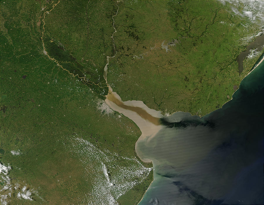
The Río de la Plata (; ), also called the River Plate or La Plata River in English, is the estuary formed by the confluence of the Uruguay River and the Paraná River at Punta Gorda, Colonia, Punta Gorda. It empties into the Atlantic Ocean and forms a funnel-shaped indentation on the southeastern coastline of South America. Depending on the geographer, the Río de la Plata may be considered a river, an estuary, a gulf, or a marginal sea. If considered a river, it is the widest in the world, with a maximum width of . The river is about long and widens from about at its source to about at its mouth. It forms part of Argentina–Uruguay border, the border between Argentina and Uruguay. The name Río de la Plata is also used to refer to the populations along the estuary, especially the main Port city, port cities of Buenos Aires and Montevideo, where Rioplatense Spanish is spoken and tango culture developed. The coasts of the river are the most densely populated areas of Urugua ... [...More Info...] [...Related Items...] OR: [Wikipedia] [Google] [Baidu] |
Santa Lucía River
The Santa Lucía River () is a river in Uruguay. Course The headwaters of the Santa Lucía River are in the Lavalleja department. For a large part of its course it forms the limit between the departments of Florida and San José on one bank and Canelones and Montevideo on the other. Its outlet is the Río de la Plata, forming a small delta, in which Tiger Island is located. Economic importance It is the principal watercourse of southern Uruguay. It is the primary source of drinking water for Montevideo and other localities in the south of the country, in 2017 serving over 60% population of Uruguay with drinking water. A harmful algae bloom in 2013, that changed the flavor and odour of the drinking water trigger public concern about water quality, resulting in a government action plan to track the quality and try to clean up the water body. The river is part of an important agricultural zone in Uruguay producing maize and corn. Environmental issues Because of its locat ... [...More Info...] [...Related Items...] OR: [Wikipedia] [Google] [Baidu] |
Brazil
Brazil, officially the Federative Republic of Brazil, is the largest country in South America. It is the world's List of countries and dependencies by area, fifth-largest country by area and the List of countries and dependencies by population, seventh-largest by population, with over 212 million people. The country is a federation composed of 26 Federative units of Brazil, states and a Federal District (Brazil), Federal District, which hosts the capital, Brasília. List of cities in Brazil by population, Its most populous city is São Paulo, followed by Rio de Janeiro. Brazil has the most Portuguese-speaking countries, Portuguese speakers in the world and is the only country in the Americas where Portuguese language, Portuguese is an Portuguese-speaking world, official language. Bounded by the Atlantic Ocean on the east, Brazil has a Coastline of Brazil, coastline of . Covering roughly half of South America's land area, it Borders of Brazil, borders all other countries and ter ... [...More Info...] [...Related Items...] OR: [Wikipedia] [Google] [Baidu] |


