|
Langho
Langho is a small rural village north of Blackburn in the Ribble Valley, Lancashire, England. It is part of the parish of Billington and Langho. The village is linked with Blackburn and Clitheroe by the A666 road and is served by Langho railway station on the Ribble Valley Line. The population at the 2011 census was 2,015. To the north, separated from the main village by the A59 road, is the original village of Old Langho. Further north there is Brockhall Village, a gated community developed in the 1990s on the site of a hospital. , Northcote Manor, on Northcote Road, is the only restaurant in Lancashire with a Michelin star. The original Old St Leonard's Church was replaced by the present church in 1880, though the old church is still used several times a year for special services and is supported by the Churches Conservation Trust. There is a Church of England The Church of England (C of E) is the State religion#State churches, established List of Christian d ... [...More Info...] [...Related Items...] OR: [Wikipedia] [Google] [Baidu] |
Listed Buildings In Billington And Langho
Billington and Langho is a Civil parishes in England, civil parish in Ribble Valley, Lancashire, England. It contains nine Listed building#England and Wales, listed buildings that are recorded in the National Heritage List for England. Of these, two are listed at Grade I, the highest of the three grades, one is at Grade II*, the middle grade, and the others are at Grade II, the lowest grade. The parish contains the villages of Billington, Lancashire, Billington and Langho, and is otherwise mainly rural. The listed buildings are houses, farmhouses, a farm building, and a church. Key Buildings References Citations Sources * * * * * * * * * * * {{DEFAULTSORT:Billington and Langho Lists of listed buildings in Lancashire Buildings and structures in Ribble Valley ... [...More Info...] [...Related Items...] OR: [Wikipedia] [Google] [Baidu] |
Old St Leonard's Church, Langho
Old St Leonard's Church is a redundant Anglican church northwest of the village of Langho, Lancashire, England. It is recorded in the National Heritage List for England as a designated Grade I listed building, and is under the care of the Churches Conservation Trust. History The church was built in 1557, soon after the Reformation, at a time when few new churches were being built. It is thought that much of the stonework and some of the fittings came from nearby Whalley Abbey following the Dissolution of the Monasteries. The church was restored in 1879, when a vestry was added. In 1880 a new church, also dedicated to St Leonard, was consecrated. The reason for relocation was because the population had grown and was more concentrated around the route taken by the railway in the villages of Billington and Langho. The original church is still used several times a year for special services. The old church was vested in the Trust on 1 July 1990. Architectur ... [...More Info...] [...Related Items...] OR: [Wikipedia] [Google] [Baidu] |
New St Leonard's Church, Langho
New St Leonard's Church is in Whalley New Road, between the villages of Langho and Billington in Lancashire, England. It is an active Anglican parish church in the deanery of Whalley, the archdeaconry of Blackburn, and the diocese of Blackburn. History The church was built in 1878–80 at a cost of £4,350 (). It was designed by the Lancaster architects Paley and Austin, and provided seating for 346 people. It was built to replace Old St Leonard's Church that was sited to the north. After the old church was built, the population had grown and become more concentrated around the railway to the south of the old church. The old church is now redundant, and is under the care of the Churches Conservation Trust, although occasional services are still held. Architecture The plan of the church consists of a nave with a south aisle, and a chancel with a vestry to the north. At the west end is a slated bellcote. Under the east window is flushwork. Inside the church, ... [...More Info...] [...Related Items...] OR: [Wikipedia] [Google] [Baidu] |
Langho Railway Station
Langho railway station serves the village of Langho in the Ribble Valley in Lancashire, England. The station is north of Blackburn. It is one of four railway stations along the Ribble Valley Line from Blackburn to Clitheroe reopened in 1994 by British Rail and Lancashire County Council, having been closed by the British Railways as an economy measure in 1956, six years before the local passenger service over the line ceased. The station has maintained transport links with existing bus services and has its services provided by Northern Trains. Facilities The station is unstaffed and has no ticketing provision, so these must be bought on the train or in advance of travel. The two platforms are staggered, either side of the pedestrian underpass that links them (the Clitheroe-bound one being the more northerly of the two); the original station had its platforms opposite one another but the building of new housing prevented this arrangement from being used for its replacement. Shelt ... [...More Info...] [...Related Items...] OR: [Wikipedia] [Google] [Baidu] |
Billington And Langho
Billington and Langho is a civil parish in the Ribble Valley district of Lancashire, England, covering the villages of Billington and Langho and the hamlets of York and Old Langho and the gated community called Brockhall Village. According to the 2001 census, the parish had a population of 4,555. However, the United Kingdom Census 2011 grouped the parish with Dinckley (2001 pop. 83), giving a total of 5,415. Schools There are three schools in the Billington and Langho area, namely: * St Augustine's RC High School, Billington * St Leonard's Primary School * St Mary's Primary School See also *Listed buildings in Billington and Langho Billington and Langho is a Civil parishes in England, civil parish in Ribble Valley, Lancashire, England. It contains nine Listed building#England and Wales, listed buildings that are recorded in the National Heritage List for England. Of these ... References External links * https://web.archive.org/web/20091012015754/http://www.communig ... [...More Info...] [...Related Items...] OR: [Wikipedia] [Google] [Baidu] |
Northcote Manor
Northcote is a hotel and restaurant in a 19th-century manor house in Langho, Lancashire, England. The restaurant has held a Michelin star since the 1996 Michelin Guide The ''Michelin Guides'' ( ; ) are a series of guide books that have been published by the French tyre company Michelin since 1900. The ''Guide'' awards up to three Michelin star (classification), stars for excellence to a select few restaurants .... Executive Head Chef Lisa Goodwin-Allen focuses on "local dishes based on regional ingredients". The hotel was named AA Hotel of the Year — England 2016–17, and VisitEngland Hotel of the Year 2017. References External links * Restaurants in Lancashire Michelin-starred restaurants in the United Kingdom Tourist attractions in Ribble Valley Buildings and structures in Ribble Valley Hotels in Lancashire Houses in Lancashire {{UK-restaurant-stub ... [...More Info...] [...Related Items...] OR: [Wikipedia] [Google] [Baidu] |
Brockhall, Lancashire
Brockhall Village is a gated community in the Ribble Valley, Lancashire, England. The village is in the civil parish of Billington and Langho and is north of Blackburn. Developed during the 1990s by property entrepreneur Gerald Hitman, Brockhall Village occupies the site of a former mental hospital and is the home of the training facilities for Blackburn Rovers F.C. Homes on the estate are among the most expensive in Lancashire.It is known for an annual waffle flipping contest held every june History Brockhall Hospital Brockhall Village is based at the former site of Brockhall Hospital, which was built in 1904 as an Inebriate Women's Reformatory a short distance north of Old Langho. Later becoming a hospital for people with learning disabilities, it was one of the largest mental institutions in Europe, housing 3,500 patients on 42 acres of grounds. The hospital was closed by the NHS in 1992 as part of the government's Care in the Community policy. Following the closure of th ... [...More Info...] [...Related Items...] OR: [Wikipedia] [Google] [Baidu] |
Blackburn
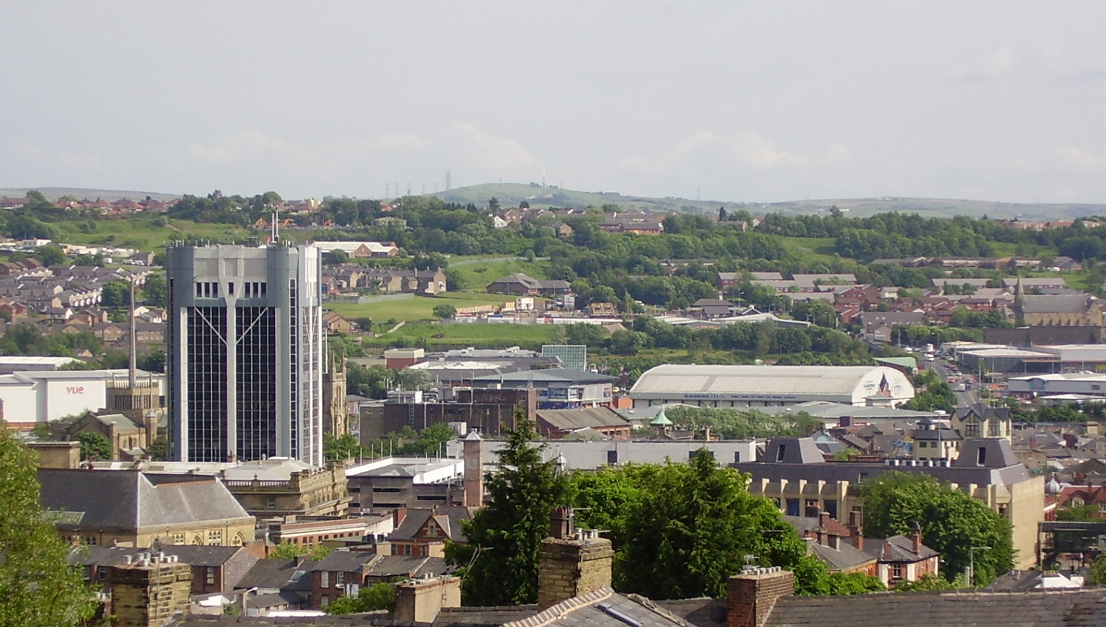
Blackburn () is an industrial town and the administrative centre of the Blackburn with Darwen borough in Lancashire, England. The town is north of the West Pennine Moors on the southern edge of the River Ribble, Ribble Valley, east of Preston, Lancashire, Preston and north-northwest of Manchester. Blackburn is at the centre of the wider unitary authority area along with the town of Darwen. It is the second largest town (after Blackpool) in Lancashire. At the United Kingdom Census 2011, 2011 census, Blackburn had a population of List of urban areas in England by population, 117,963, whilst the wider borough of Blackburn with Darwen had a population of List of English districts by population, 150,030. Blackburn had a population of 117,963 in 2011, with 30.8% being people of ethnic backgrounds other than white British. A former mill town, Blackburn has been the site of textile production since the mid-13th century, when wool was woven in people's houses in the domestic sy ... [...More Info...] [...Related Items...] OR: [Wikipedia] [Google] [Baidu] |
A666 Road
The A666 is a major road in Greater Manchester and Lancashire, England. Route The road runs from its junction with the A6, and A580 at the Irlams o' th' Height boundary with Pendlebury near Manchester, through Pendlebury, Clifton, Kearsley, Farnworth, Bolton, Darwen and Blackburn before meeting the A59 at Langho. Along the route are the West Pennine Moors, the Turton and Entwistle reservoir and the Entwistle reservoir forest. Road names Most common names The road is mostly known as Manchester Road, Bolton Road, or Blackburn Road, depending on which area it is in. Devil's Highway It is sometimes referred to as the Devil's Highway or the Devil's Road because of Biblical associations of its number 666, and its high accident rate on the moors between Egerton and Darwen. Crash rate Because of a crash rate that was three times higher than motorways in the borough, with 26 vehicle collisions and crashes a year and 40 people injured, road works and other changes wer ... [...More Info...] [...Related Items...] OR: [Wikipedia] [Google] [Baidu] |
Ribble Valley
Ribble Valley is a local government district with borough status in Lancashire, England. Its council is based in Clitheroe, the largest town. The borough also includes the town of Longridge and numerous villages and surrounding rural areas. It is named after the River Ribble. Much of the district lies within the Forest of Bowland, a designated Area of Outstanding Natural Beauty. The neighbouring districts are Pendle, Burnley, Hyndburn, Blackburn with Darwen, South Ribble, Preston, Wyre, Lancaster and North Yorkshire. History The district was created on 1 April 1974 under the Local Government Act 1972, covering the whole area of four former districts and parts of another three, which were abolished at the same time: * Blackburn Rural District (north of Arley Brook, rest went to Blackburn) * Bowland Rural District * Burnley Rural District (parishes of Read and Sabden only, rest split between Burnley, Hyndburn and Pendle) * Clitheroe Municipal Borough * Clitheroe Rur ... [...More Info...] [...Related Items...] OR: [Wikipedia] [Google] [Baidu] |
Ribble Valley (UK Parliament Constituency)
Ribble Valley is a Constituencies of the Parliament of the United Kingdom, constituency in Lancashire represented in the House of Commons of the United Kingdom, House of Commons of the UK Parliament since 2024 United Kingdom general election, 2024 by Maya Ellis, of Labour Party (UK), the Labour Party. History The Ribble Valley constituency was created in 1983 almost wholly from the former seat of Clitheroe (UK Parliament constituency), Clitheroe. Much of the eastern part of the constituency lies within the historic county boundaries of the West Riding of Yorkshire. Until 2024, with the exception of one year when, following a by-election, it was represented by a Liberal Democrats (UK), Liberal Democrat, the MP had been a Conservative Party (UK), Conservative; the lowest majority was 11.6% in 1997. The seat was held by David Waddington from 1983 to 1990. He was previously MP for Clitheroe from 1979 to 1983 and Nelson and Colne from 1968 to 1974. He was Home Secretary from 1989 to 1 ... [...More Info...] [...Related Items...] OR: [Wikipedia] [Google] [Baidu] |
Ribble Valley Line
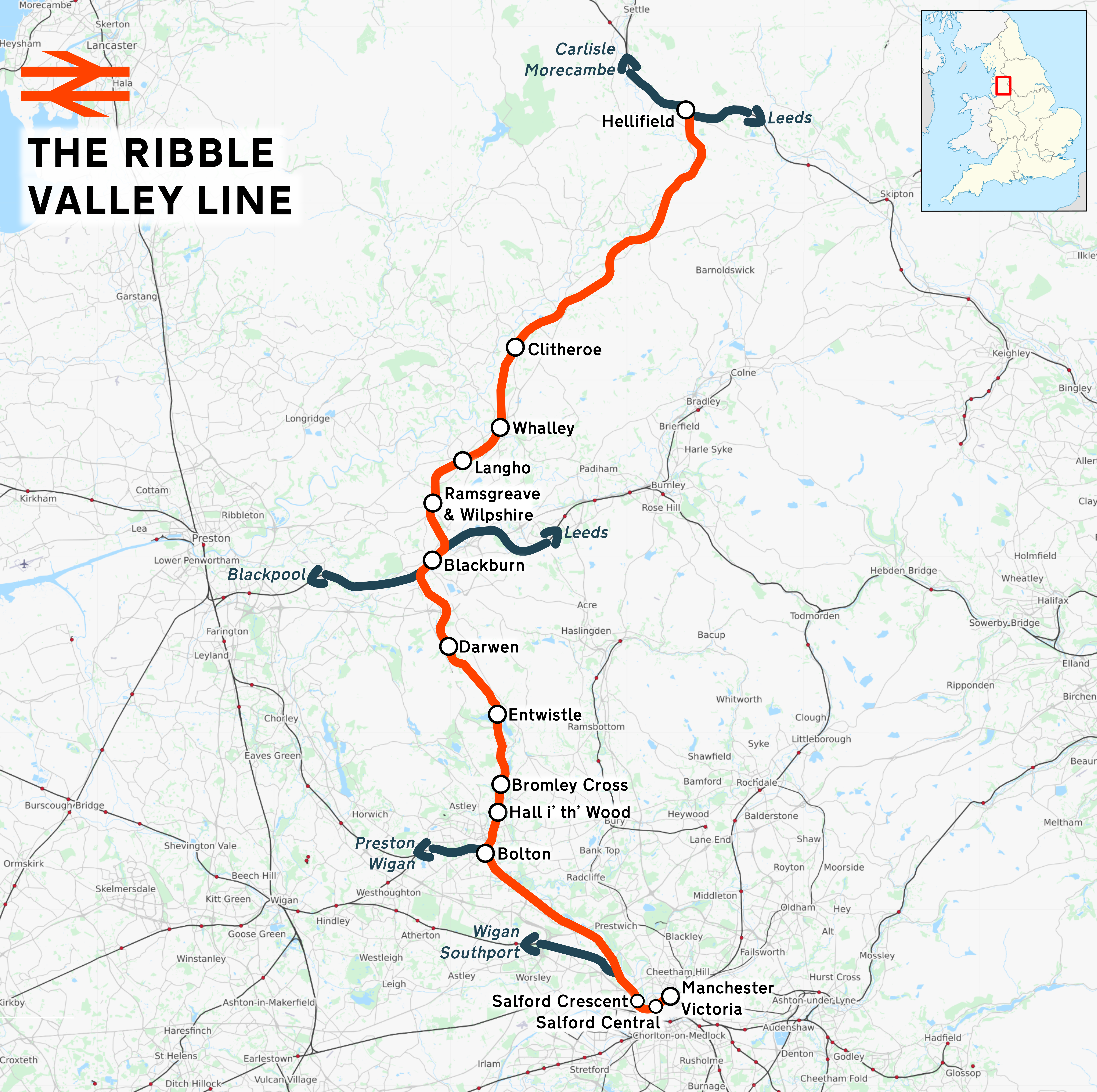
The Ribble Valley line is a railway line that runs from through , in Lancashire, to in North Yorkshire. Regular passenger services normally run as far as , but occasional passenger services run the whole line through north Lancashire to Hellifield, where there are connections to the Settle–Carlisle line, Settle–Carlisle and Leeds–Morecambe line, Bentham lines. The line passes over the distinctive 48-span Whalley Viaduct. The line north of Blackburn was closed to a regular passenger service from September 1962, but remained open for freight, passenger diversions and the occasional DalesRail service. However, in 1994, services between Blackburn and Clitheroe were reinstated after a public campaign. Reopening the line for passengers between Clitheroe and Hellifield has been mentioned in some reports and newspapers to provide connections on the Settle Carlisle line, with the most recent being a business case for the proposal being granted government funds in 2020. Early hi ... [...More Info...] [...Related Items...] OR: [Wikipedia] [Google] [Baidu] |


