|
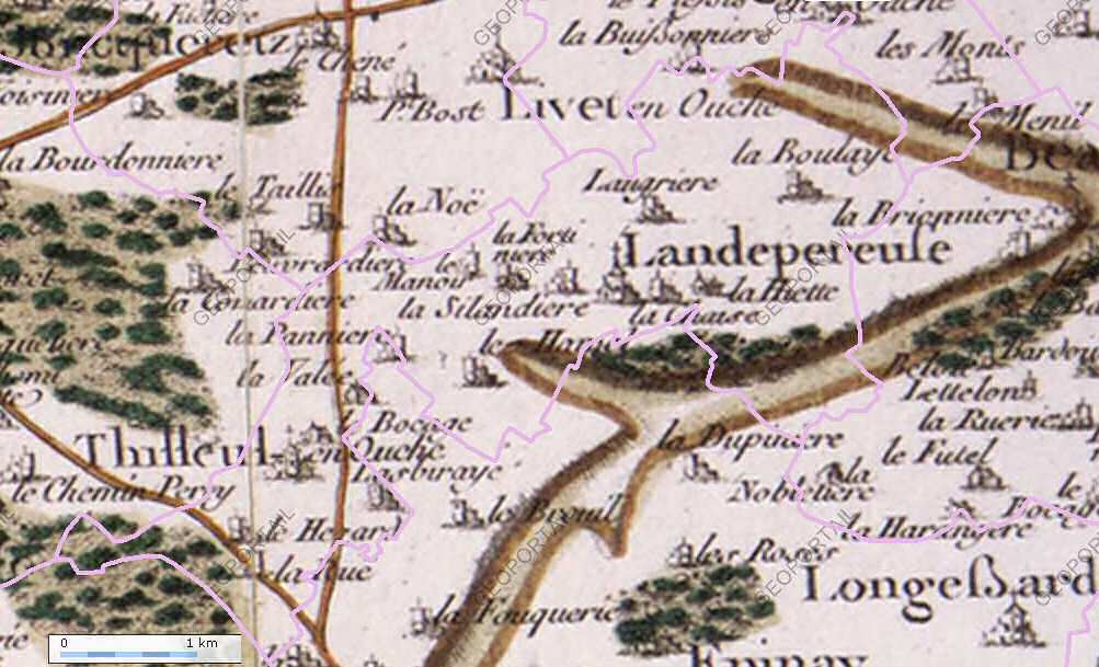
Landepéreuse
Landepéreuse () is a former Communes of France, commune in the Eure Departments of France, department, in Normandy (administrative region), Normandy in northern France. On 1 January 2016, it was merged into the new commune of Mesnil-en-Ouche. Etymology The name "Landepereuse" derives from the Norman pronunciation of ''lande pierreuse'' ("stony ground"). The word ''lande'' comes from the Gaulish language, and refers to dry ground where few plants grow. "Stony" refers to the local abundance and size of stones. Geography Landepéreuse is a small rural village in the Pays d'Ouche, located in the south-western Eure. Its surface is 892 hectares. Its maximum altitude change is 48 m but ranges between 187 m in the south-west and 139 m in the north-east; the town hall is at 170 m. This slightly undulating countryside is characteristic of the topography in the Pays d'Ouche, already hinted at in the hills of the Perche country to the south and the Pays d'Auge a few kilometres to the wes ... [...More Info...] [...Related Items...] OR: [Wikipedia] [Google] [Baidu] |
Mesnil-en-Ouche
Mesnil-en-Ouche (, literally '' Mesnil in Ouche'') is a commune in the department of Eure, northern France. The municipality was established on 1 January 2016 by merger of the 16 former communes of Ajou, La Barre-en-Ouche, Beaumesnil (the seat), Bosc-Renoult-en-Ouche, Épinay, Gisay-la-Coudre, Gouttiéres, Granchain, Jonquerets-de-Livet, Landepéreuse, La Roussière, Saint-Aubin-des-Hayes, Saint-Aubin-le-Guichard, Sainte-Marguerite-en-Ouche, Saint-Pierre-du-Mesnil and Thevray. 9 December 2015 Geography The commune along with another 69 communes shares part of a 4,747 hectare, Natura 2000 conservation area, called[...More Info...] [...Related Items...] OR: [Wikipedia] [Google] [Baidu] |
Institut National De La Statistique Et Des études économiques
The National Institute of Statistics and Economic Studies (, ), abbreviated INSEE or Insee ( , ), is the List of national and international statistical services, national statistics bureau of France. It collects and publishes information about the Economy of France, French economy and Demographics of France, people and carries out the periodic national census. Headquartered in Montrouge, a commune in the southern Paris, Parisian suburbs, it is the French branch of Eurostat. The INSEE was created in 1946 as a successor to the Vichy France, Vichy regime's National Statistics Service (SNS). It works in close cooperation with the Institut national d'études démographiques (INED). Purpose The INSEE is responsible for the production and analysis of official statistics in France. Its best known responsibilities include: * Organising and publishing the national census. * Producing various Index (economics), indices – which are widely recognised as being of excellent quality – inc ... [...More Info...] [...Related Items...] OR: [Wikipedia] [Google] [Baidu] |
Holocene
The Holocene () is the current geologic time scale, geological epoch, beginning approximately 11,700 years ago. It follows the Last Glacial Period, which concluded with the Holocene glacial retreat. The Holocene and the preceding Pleistocene together form the Quaternary period. The Holocene is an interglacial period within the ongoing Ice age, glacial cycles of the Quaternary, and is equivalent to Marine isotope stages, Marine Isotope Stage 1. The Holocene correlates with the last maximum axial tilt towards the Sun of the Earth#Axial tilt and seasons, Earth's obliquity. The Holocene corresponds with the rapid proliferation, growth, and impacts of the human species worldwide, including Recorded history, all of its written history, technological revolutions, development of major civilizations, and overall significant transition towards urban culture, urban living in the present. The human impact on modern-era Earth and its ecosystems may be considered of global significance for th ... [...More Info...] [...Related Items...] OR: [Wikipedia] [Google] [Baidu] |
Fontainebleau
Fontainebleau ( , , ) is a Communes of France, commune in the Functional area (France), metropolitan area of Paris, France. It is located south-southeast of the Kilometre zero#France, centre of Paris. Fontainebleau is a Subprefectures in France, sub-prefecture of the Seine-et-Marne Departments of France, department, and it is the seat of the Arrondissement of Fontainebleau, ''arrondissement'' of Fontainebleau. The commune has the largest land area in the Île-de-France region; it is the only one to cover a larger area than Paris itself. The commune is closest to Seine-et-Marne Prefecture Melun. Fontainebleau, together with the neighbouring commune of Avon, Seine-et-Marne, Avon and three other smaller communes, form an urban area of 36,724 inhabitants (2018). This urban area is a satellite of Paris. Fontainebleau is renowned for the large and scenic Forest of Fontainebleau, a favourite weekend getaway for Parisians, as well as for the historic Palace of Fontainebleau, Château ... [...More Info...] [...Related Items...] OR: [Wikipedia] [Google] [Baidu] |
Oligocene
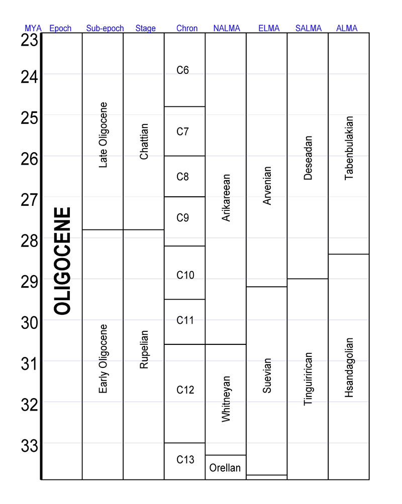
The Oligocene ( ) is a geologic epoch (geology), epoch of the Paleogene Geologic time scale, Period that extends from about 33.9 million to 23 million years before the present ( to ). As with other older geologic periods, the rock beds that define the epoch are well identified but the exact dates of the start and end of the epoch are slightly uncertain. The name Oligocene was coined in 1854 by the German paleontologist Heinrich Ernst Beyrich from his studies of marine beds in Belgium and Germany. The name comes from Ancient Greek (''olígos'') 'few' and (''kainós'') 'new', and refers to the sparsity of Neontology, extant forms of Mollusca, molluscs. The Oligocene is preceded by the Eocene Epoch and is followed by the Miocene Epoch. The Oligocene is the third and final epoch of the Paleogene Period. The Oligocene is often considered an important time of transition, a link between the archaic world of the tropical Eocene and the more modern ecosystems of the Miocene. Major chang ... [...More Info...] [...Related Items...] OR: [Wikipedia] [Google] [Baidu] |
Le Bosc-Renoult
Le Bosc-Renoult is a commune in the Orne department in northwestern France. Geography The commune along with another 11 communes shares part of a 1,400 hectare, Natura 2000 conservation area, called the Haute Vallée de la Touques et affluents. Population See also *Communes of the Orne department The following is a list of the 381 communes of the Orne department of France. The communes cooperate in the following intercommunalities (as of 2025): References Communes of Orne {{MortagneauPerche-geo-stub ...[...More Info...] [...Related Items...] OR: [Wikipedia] [Google] [Baidu] |
Le Tréport
Le Tréport () is a commune in the Seine-Maritime department in Normandy, France. The three adjoining towns of Le Tréport, Eu and Mers-les-Bains are known locally as the "Three Sisters". Geography A small fishing port and light industrial town situated in the Pays de Caux, some northeast of Dieppe at the junction of the D 940, the D 78 and the D 1015 roads. The mouth of the river Bresle meets the English Channel here, in between the high () chalk cliffs and the pebbly beach. Le Tréport-Mers station has rail connections to Beauvais. Le Tréport is also a sea-side resort and home to a casino. History Le Tréport (the ancient ''Ulterior Portus'') was a port of some note in the Middle Ages, when it experienced several invasions by English forces. Louis Philippe I twice received Queen Victoria at Tréport, in 1843 and 1845. The patronage of Louis-Philippe and his family, residing regularly in Eu, inaugurated Le Tréport as a popular seaside resort. The Parisian upper ... [...More Info...] [...Related Items...] OR: [Wikipedia] [Google] [Baidu] |
Dieppe
Dieppe (; ; or Old Norse ) is a coastal commune in the Seine-Maritime department, Normandy, northern France. Dieppe is a seaport on the English Channel at the mouth of the river Arques. A regular ferry service runs to Newhaven in England. Famous for its scallops, Dieppe also has a popular pebbled beach, a 15th-century castle and the churches of Saint-Jacques and Saint-Remi. The mouth of the river Scie lies at Hautot-sur-Mer, directly to the west of Dieppe. The inhabitants of the town of Dieppe are called () and () in French. History First recorded as a small fishing settlement in 1030, Dieppe was an important prize fought over during the Hundred Years' War. It housed the most advanced French school of cartography in the 16th century. Two of France's best navigators, Michel le Vasseur and his brother Thomas le Vasseur, lived in Dieppe when they were recruited to join the expedition of René Goulaine de Laudonnière which departed Le Havre for Florida on April ... [...More Info...] [...Related Items...] OR: [Wikipedia] [Google] [Baidu] |
Paleocene
The Paleocene ( ), or Palaeocene, is a geological epoch (geology), epoch that lasted from about 66 to 56 mya (unit), million years ago (mya). It is the first epoch of the Paleogene Period (geology), Period in the modern Cenozoic Era (geology), Era. The name is a combination of the Ancient Greek ''palaiós'' meaning "old" and the Eocene Epoch (which succeeds the Paleocene), translating to "the old part of the Eocene". The epoch is bracketed by two major events in Earth's history. The K–Pg extinction event, brought on by an asteroid impact (Chicxulub impact) and possibly volcanism (Deccan Traps), marked the beginning of the Paleocene and killed off 75% of species, most famously the non-avian dinosaurs. The end of the epoch was marked by the Paleocene–Eocene Thermal Maximum (PETM), which was a major climatic event wherein about 2,500–4,500 gigatons of carbon were released into the atmosphere and ocean systems, causing a spike in global temperatures and ocean acidification. ... [...More Info...] [...Related Items...] OR: [Wikipedia] [Google] [Baidu] |
Cenozoic
The Cenozoic Era ( ; ) is Earth's current geological era, representing the last 66million years of Earth's history. It is characterized by the dominance of mammals, insects, birds and angiosperms (flowering plants). It is the latest of three geological eras of the Phanerozoic Eon, preceded by the Mesozoic and Paleozoic. The Cenozoic started with the Cretaceous–Paleogene extinction event, when many species, including the non-avian dinosaurs, became extinct in an event attributed by most experts to the impact of a large asteroid or other celestial body, the Chicxulub impactor. The Cenozoic is also known as the Age of Mammals because the terrestrial animals that dominated both hemispheres were mammalsthe eutherians ( placentals) in the Northern Hemisphere and the metatherians (marsupials, now mainly restricted to Australia and to some extent South America) in the Southern Hemisphere. The extinction of many groups allowed mammals and birds to greatly diversify so that large m ... [...More Info...] [...Related Items...] OR: [Wikipedia] [Google] [Baidu] |
Sandstone
Sandstone is a Clastic rock#Sedimentary clastic rocks, clastic sedimentary rock composed mainly of grain size, sand-sized (0.0625 to 2 mm) silicate mineral, silicate grains, Cementation (geology), cemented together by another mineral. Sandstones comprise about 20–25% of all sedimentary rocks. Most sandstone is composed of quartz or feldspar, because they are the most resistant minerals to the weathering processes at the Earth's surface. Like uncemented sand, sandstone may be imparted any color by impurities within the minerals, but the most common colors are tan, brown, yellow, red, grey, pink, white, and black. Because sandstone beds can form highly visible cliffs and other topography, topographic features, certain colors of sandstone have become strongly identified with certain regions, such as the red rock deserts of Arches National Park and other areas of the Southwestern United States, American Southwest. Rock formations composed of sandstone usually allow the p ... [...More Info...] [...Related Items...] OR: [Wikipedia] [Google] [Baidu] |


