|
Lampung Bay
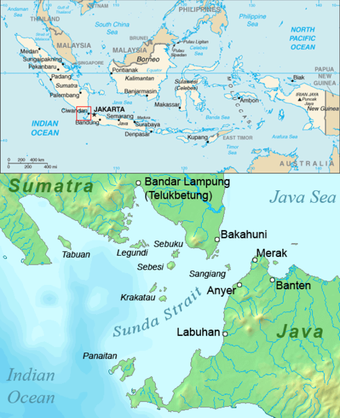
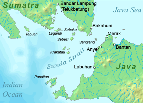
Lampung Bay ( id, Teluk Lampung) is a large bay located on the southern tip of Sumatra Island in the Sunda Strait waters. At the southern tip of Sumatra there are two large bays, Semangka Bay is located in the Eastern part. On the east side of the bay stretches Lampung, with the capital city of Lampung located at the northern end of the bay. Two rivers that discharge into the Bay divide Bandar Lampung City. Lampung bay is located between Bandar Lampung City, South Lampung Regency and Pesawaran Regency. Panjang Port is also located in this bay. The Bay of Lampung, which covers an area of 1,888 square km, is a shallow water area with an average depth of 20 meters. The Bay contains a significant Mangrove ecosystem that would be a good candidate for mangrove restoration. A 2020 survey of stakeholders in the bay, including artisanal fishers, shrimp fishers and other fishery communities found that the communities preferred restoration processes focused on mangrove tourism. ... [...More Info...] [...Related Items...] OR: [Wikipedia] [Google] [Baidu] |
Mount Kunyit
Mount Kunyit (, "Turmeric Mountain"; also known as ''Bukit Belerang'') is a fumarolic stratovolcano on Talang Kemuning Village, Gunung Raya District, Kerinci Regency, Jambi, Sumatra, Indonesia. The summit contains two crater Crater may refer to: Landforms *Impact crater, a depression caused by two celestial bodies impacting each other, such as a meteorite hitting a planet *Explosion crater, a hole formed in the ground produced by an explosion near or below the surfac ...s; the uppermost is a crater lake. See also * List of volcanoes in Indonesia References Kunyit Kunyit Kunyit Kunyit Pleistocene stratovolcanoes {{Jambi-geo-stub ... [...More Info...] [...Related Items...] OR: [Wikipedia] [Google] [Baidu] |
Shrimp Fishery
The shrimp fishery is a major global industry, with more than 3.4 million tons caught per year, chiefly in Asia. Rates of bycatch are unusually high for shrimp fishing, with the capture of sea turtles being especially contentious. A shrimper is a fishing vessel rigged for shrimp fishing. Nomenclature The term ''shrimp'', as used by the Food and Agriculture Organization (FAO), covers all shrimp ( Caridea) and prawns (Dendrobranchiata, comprising Penaeoidea and Sergestoidea) – a group formerly known as " Natantia". Gillett (2008), p. 5. This nomenclature often differs from local use, in which the same species may be known by different names, or where different species may be known by the same name. Gillett (2008), p. 26. History Small-scale local fishery for shrimp and prawns has existed for centuries and continues to form a large proportion of the world's shrimp fisheries. Gillett (2008), p. 9. Trawling increased in scale with the introduction of otter boards, which use the ... [...More Info...] [...Related Items...] OR: [Wikipedia] [Google] [Baidu] |
Tegal Mas Island
Tegal is a city in the northwest part of Central Java of Indonesia. It is situated on the north coast (or ''pesisir'') of Central Java, about from Semarang, the capital of the province. It had a population of 239,599 at the 2010 Census and 276,734 at the 2015 Census. Its built-up (''or metro'') area made up of Tegal Municipality and 12 districts spread over Tegal and Brebes Regencies was home to 1,366,858 inhabitants as of 2010 census. It is administratively separate from Tegal Regency, which borders it to the south and east; Brebes Regency borders it to the west. The Dutch East Indies colonial sugar industry originated in Tegal and the nearby city of Pekalongan, approximately to the east. Tegal Regency remained a major sugar production center until the mid-20th century. The city served as a port for exporting sugar produced on the nearby plantations. Tegal is famous for its warung, commonly called "warteg" or warung tegal. It is also known for its tea products, such as teh b ... [...More Info...] [...Related Items...] OR: [Wikipedia] [Google] [Baidu] |
Condong Laut Island
( ban, ᬘᭀᬦ᭄ᬤᭀᬂ) is a Balinese dance which is often performed as a preface to legong and accompanied by the semar pangulingan style of gamelan. The term also refers to a stock character, a quintessential representation of the maidservant, found in the condong dance, as well as the legong, gambuh, and arja dances. History The condong dance originated in the by palaces of Bali in the mid-19th century. Its creator is not known, but folk history suggests that a prince of Sukawati, deathly ill, saw a vision of two beautiful girls dancing gracefully while accompanied by gamelan music; upon regaining his health, this prince recreated the dance he had seen. It originally told the story of two '' bidadari'' (nymphs) named Supraba and Wilotama. By the 1930s the story had been modified, telling of a king or queen and their subject. In current performances, the condong dancer plays the role of the subject. The choreographer Ni Ketut Arini describes the condong dancer as ... [...More Info...] [...Related Items...] OR: [Wikipedia] [Google] [Baidu] |
Legundi Island
Pulau Legundi (also spelled Lagoendi) is an Indonesian island in the Sunda Strait between Java and Sumatra. It is one of the larger islands in the Strait and lies at the western end of Sumatra's Lampong Bay, in the province of Lampung. Population & Surroundings Although not so far from the mainland, Legundi is sparsely populated with about 80 inhabitants per square kilometer. Due to being lowly populated, agricultural cultivation has never been practiced on a large scale, which has kept intact the island's natural evergreen and semi-deciduous forests. Tabuan Island is to the west. Environment Due to the island's tropical nature and close proximity to the equator The equator is a circle of latitude, about in circumference, that divides Earth into the Northern and Southern hemispheres. It is an imaginary line located at 0 degrees latitude, halfway between the North and South poles. The term can al ..., seasons are not so distinct and temperatures are not so fluctuat ... [...More Info...] [...Related Items...] OR: [Wikipedia] [Google] [Baidu] |
Sebuku (Sumatra)
Sebuku (also spelled Seboekoe or Sebeekee) is an island in the Sunda Strait between Java and Sumatra. It is one of the larger islands in the strait and lies just to the north of Sebesi and south of Sumatra. It is administratively part of South Lampung Regency, Lampung. History At the time of the 1883 eruption of Krakatoa, Sebuku was uninhabited, but a village on Sebuku Ketjil, a small island to its east, was completely wiped out. Official records give 150 killed, with 70 being non-residents. In the 1920s, copra palms were planted on Sebuku to satisfy the growing market. However, due to a lack of maintenance the palms eventually withered and died. In 1999 a sunken Japanese ship was found near Sebuku by divers preparing for an underwater photography contest. Its age is unknown. Geography Sebuku is a low island, located in the eastern part of the mouth of Lampung Bay, north of Sebesi and south of Sumatra. It covers a total area of . It is administratively part of South La ... [...More Info...] [...Related Items...] OR: [Wikipedia] [Google] [Baidu] |
Sebesi
Sebesi (also Sebeezee, or 'Bleezie') is an Indonesian island in the Sunda Strait, between Java and Sumatra, and part of the province of Lampung. It rises to a height of and lies about north of the Krakatoa Archipelago; it is the closest large island to Krakatoa, about the same area and height as the remnant of Rakata. Like Krakatoa, it too is volcanic, although there are no dated eruptions known. (A single report of an eruption in 1680 seems to be a confusion with the Krakatoa eruption reported from that year.) Unlike the Krakatoa Archipelago, Sebesi has permanent streams and is inhabited. Habitation is concentrated most heavily on the northern and eastern coasts of the island. Sebesi was devastated during the 1883 volcanic eruption of Krakatoa. Official records give approximately 3,000 people killed, with 1,000 of these being 'non-residents'. By 1890, Sebesi was being re-cleared. It is believed that since it lies closer to Sumatra, it has served as a 'stepping stone' for ... [...More Info...] [...Related Items...] OR: [Wikipedia] [Google] [Baidu] |
Pasaran
:''The pasaran is also a cycle in the Javanese calendar. Pasaran is a reclaimed island in the province of Lampung, Indonesia. The island is about 1 km from the provincial capital, Bandar Lampung and is administratively part of the city. It has an area of approximately 11.73 hectares and a population of about 600 in 250 households. References {{Lampung-geo-stub Islands of Sumatra ... [...More Info...] [...Related Items...] OR: [Wikipedia] [Google] [Baidu] |
Mangrove Tourism
A mangrove is a shrub or tree that grows in coastal saline or brackish water. The term is also used for tropical coastal vegetation consisting of such species. Mangroves are taxonomically diverse, as a result of convergent evolution in several plant families. They occur worldwide in the tropics and subtropics and even some temperate coastal areas, mainly between latitudes 30° N and 30° S, with the greatest mangrove area within 5° of the equator. Mangrove plant families first appeared during the Late Cretaceous to Paleocene epochs, and became widely distributed in part due to the movement of tectonic plates. The oldest known fossils of mangrove palm date to 75 million years ago. Mangroves are salt-tolerant trees, also called halophytes, and are adapted to live in harsh coastal conditions. They contain a complex salt filtration system and a complex root system to cope with saltwater immersion and wave action. They are adapted to the low-oxygen conditions of wate ... [...More Info...] [...Related Items...] OR: [Wikipedia] [Google] [Baidu] |
Artisanal Fishers
Artisanal fishing (or traditional/subsistence fishing) consists of various small-scale, low-technology, low-capital, fishing practices undertaken by individual fishing households (as opposed to commercial fishing). Many of these households are of coastal or island ethnic groups. These households make short (rarely overnight) fishing trips close to the shore. Their produce is usually not processed and is mainly for local consumption. Artisan fishing uses traditional fishing techniques such as rod and tackle, fishing arrows and harpoons, cast nets, and small (if any) traditional fishing boats. For that reason, socio-economic status of artisanal fishing community has become an interest of the authorities in recent years. Artisan fishing may be undertaken for both commercial and subsistence reasons. It contrasts with large-scale modern commercial fishing practices in that it is often less wasteful and less stressful on fish populations than modern industrial fishing. Target 14.b ... [...More Info...] [...Related Items...] OR: [Wikipedia] [Google] [Baidu] |


