|
Kyzylart Pass
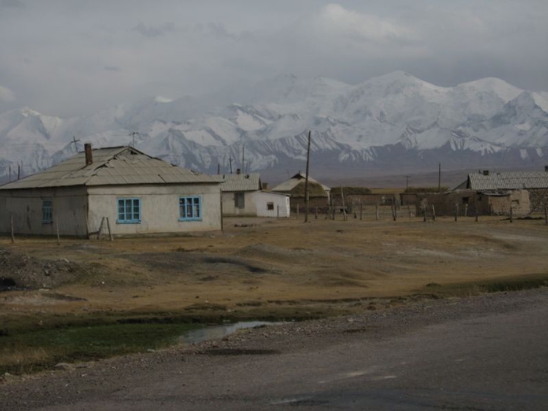
Kyzylart Pass (; ) is a mountain pass and border crossing in the Trans-Alay Range on the border of Tajikistan and Kyrgyzstan. The highest point is 4,280 m (14,042 ft). The border checkpoint on the Kyrgyz side is Bor-Döbö. accessed 31 January 2022. The area is typically rugged and dry. It is crossed by the which leads south from in the up onto the [...More Info...] [...Related Items...] OR: [Wikipedia] [Google] [Baidu] |
Kyrgyzstan
Kyrgyzstan, officially the Kyrgyz Republic, is a landlocked country in Central Asia lying in the Tian Shan and Pamir Mountains, Pamir mountain ranges. Bishkek is the Capital city, capital and List of cities in Kyrgyzstan, largest city. Kyrgyzstan is bordered by Kazakhstan to the Kazakhstan–Kyrgyzstan border, north, Uzbekistan to the Kyrgyzstan–Uzbekistan border, west, Tajikistan to the Kyrgyzstan–Tajikistan border, south, and China to the China–Kyrgyzstan border, east and southeast. Ethnic Kyrgyz people, Kyrgyz make up the majority of the country's over 7 million people, followed by significant minorities of Uzbeks and Russians. Kyrgyzstan's history spans a variety of cultures and empires. Although geographically isolated by its highly mountainous terrain, Kyrgyzstan has been at the crossroads of several great civilizations as part of the Silk Road along with other commercial routes. Inhabited by a succession of tribes and clans, Kyrgyzstan has periodically fallen unde ... [...More Info...] [...Related Items...] OR: [Wikipedia] [Google] [Baidu] |
Tajikistan
Tajikistan, officially the Republic of Tajikistan, is a landlocked country in Central Asia. Dushanbe is the capital city, capital and most populous city. Tajikistan borders Afghanistan to the Afghanistan–Tajikistan border, south, Uzbekistan to the Tajikistan–Uzbekistan border, west, Kyrgyzstan to the Kyrgyzstan–Tajikistan border, north, and China to the China–Tajikistan border, east. It is separated from Pakistan by Afghanistan's Wakhan Corridor. It has a population of over 10.7 million people. The territory was previously home to cultures of the Neolithic and the Bronze Age, including the Bactria–Margiana Archaeological Complex, Oxus civilization in west, with the Indo-Iranians arriving during the Andronovo culture. Parts of country were part of the Sogdia, Sogdian and Bactria, Bactrian civilizations, and was ruled by those including the Achaemenid Empire, Achaemenids, Alexander the Great, the Greco-Bactrian Kingdom, Greco-Bactrians, the Kushan Empire, Kushans, the Kid ... [...More Info...] [...Related Items...] OR: [Wikipedia] [Google] [Baidu] |
Trans-Alay Range
The Trans-Alay or Trans-Alai Range (, ; , , or , ; , ) is the northernmost range of the Pamir Mountain System. Following the collapse of the Soviet Union, the range has been divided between Tajikistan and Kyrgyzstan. Geography The Trans-Alay is located in the area where the Pamirs and the Tian Shan come together. This heavily glaciated range forms the border between the Gorno-Badakshan region in Tajikistan and the Osh Region, Kyrgyzstan, stretching eastwards until the border with China. The name was from the viewpoint of Russian explorers in the region: The Alay Range lies to the north of the Alay Valley, formed by the Kyzyl-Suu or upper Vakhsh River, one of the principal tributaries of the Amu Darya. The range on the far side of the valley, more distant from Russia and its outposts, became known as the Trans-Alay. The southern valley dividing the Trans-Alay from the Pamir proper is that of the river Muksu. Peaks The highest peak in the range is the 7134 m high Ibn Sina/L ... [...More Info...] [...Related Items...] OR: [Wikipedia] [Google] [Baidu] |
Mountain Pass
A mountain pass is a navigable route through a mountain range or over a ridge. Since mountain ranges can present formidable barriers to travel, passes have played a key role in trade, war, and both Human migration, human and animal migration throughout history. At lower elevations it may be called a hill pass. A mountain pass is typically formed between two volcanic peaks or created by erosion from water or wind. Overview Mountain passes make use of a gap (landform), gap, saddle (landform), saddle, col or notch (landform), notch. A topographic saddle is analogous to the mathematical concept of a saddle surface, with a saddle point marking the minimum high point between two valleys and the lowest point along a ridge. On a topographic map, passes can be identified by contour lines with an hourglass shape, which indicates a low spot between two higher points. In the high mountains, a difference of between the summit and the mountain is defined as a mountain pass. Passes are o ... [...More Info...] [...Related Items...] OR: [Wikipedia] [Google] [Baidu] |
Pamir Highway
The M41, known informally and more commonly as the Pamir Highway (), is a road traversing the Pamir Mountains through Afghanistan, Uzbekistan, Tajikistan and Kyrgyzstan with a length of over 1,200 km. It is the only continuous route through the difficult terrain of the mountains and is the main supply route to Tajikistan's Gorno-Badakhshan Autonomous Region. The route has been in use for millennia, as there are a limited number of viable routes through the high Pamir Mountains. The road formed one link of the ancient Silk Road trade route. M41 is the Soviet road number, but it only remains as an official designation in post-Soviet Uzbekistan, as confirmed by official decree.Decree of the Republic of Uzbekistan Cabinet. Approval of the List of Public Roads of the Republic of Uzbekistan. 5 August 2010https://lex.uz/docs/-1664887/ref> KyrgyzstanProcedure. Classification and numbering of public highways in the territory of the Kyrgyz Republic. 18 August 2017http://cbd.minjust.gov.kg/a ... [...More Info...] [...Related Items...] OR: [Wikipedia] [Google] [Baidu] |
Sary-Tash
Sary-Tash () is a village and major crossroads in the Alay Valley of Osh Region, Kyrgyzstan. Its population was 2,337 in 2021. Until 2012 it was an urban-type settlement. Nearby towns and villages to the north include Ak-Bosogo () and Chagyr (). Although this remote village has only some shop-cafes, a petrol station and five guest houses (March 2016), it is an important road junction connecting China, Kyrgyzstan and Tajikistan. Its name is derived from Turkic roots and means "yellow-stone". To the north, M41 goes over the Taldyk Pass to Gülchö and Osh in the Ferghana Valley. To the south, after leaving the Alay Valley the M41 rises to the 4280m Kyzylart Pass into Tajikistan as part of the Pamir Highway. to the east on A371 is the Irkestam pass to Kashgar, Xinjiang province, China. To the west, the A372 leads down the Alay Valley The Alai Valley is a broad, dry valley running east–west across most of southern Osh Region of Kyrgyzstan in Central Asia. Geography The ... [...More Info...] [...Related Items...] OR: [Wikipedia] [Google] [Baidu] |
Alay Valley
The Alai Valley is a broad, dry valley running east–west across most of southern Osh Region of Kyrgyzstan in Central Asia. Geography The valley spreads over a length of east–west. It has a width of in the west, in the central part, and in the east. The altitude of the valley ranges from near Karamyk to at the Taunmurun Pass with an average altitude of about . The area of the valley is . The north side is the Alay Mountains which slope down to the Ferghana Valley. The south side is the Trans-Alay Range along the Tajikistan border, with Lenin Peak, (). The western or so is more hills than valley. On the east lies the Taunmurun (alternative spellings Taukmurun and Tongmurun) Pass and then more valley leading to the Erkeshtam border crossing to China. The eastern Kyzyl-Suu River, Kyzyl-Suu ('Red River') flows from the Taunmurun Pass past Erkeshtam toward Kashgar. The western Kyzyl-Suu flows west from the Taunmurun Pass and drains most of the valley, flowing on the north ... [...More Info...] [...Related Items...] OR: [Wikipedia] [Google] [Baidu] |
Pamir Mountains
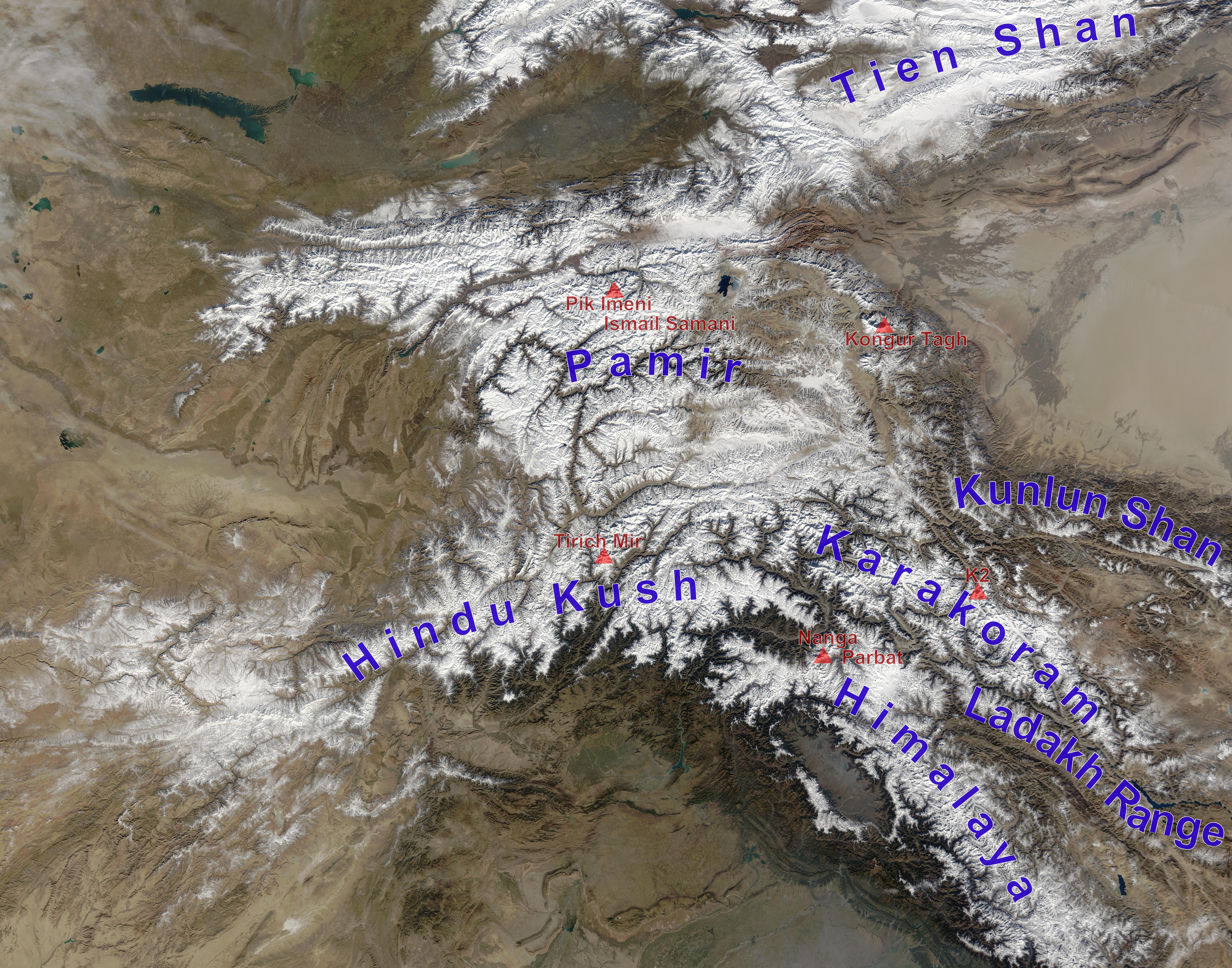
The Pamir Mountains are a Mountain range, range of mountains between Central Asia and South Asia. They are located at a junction with other notable mountains, namely the Tian Shan, Karakoram, Kunlun Mountains, Kunlun, Hindu Kush and the Himalayas, Himalaya mountain ranges. They are among the world's highest mountains. Much of the Pamir Mountains lie in the Gorno-Badakhshan region of Tajikistan. Spanning the border parts of four countries, to the south, they border the Hindu Kush mountains along Afghanistan's Wakhan Corridor in Badakhshan Province, Chitral District, Chitral and Gilgit-Baltistan regions of Pakistan. To the north, they join the Tian Shan mountains along the Alay Valley of Kyrgyzstan. To the east, they extend to the range that includes China's Kongur Tagh, in the "Eastern Pamirs", separated by the Yarkand River, Yarkand valley from the Kunlun Mountains. Since the Victorian era, they have been known as the "Roof of the World", presumably a translation from Persian ... [...More Info...] [...Related Items...] OR: [Wikipedia] [Google] [Baidu] |
Karakul (Tajikistan)
Karakul or Qarokul ( Kyrgyz for "black lake", replacing the older Tajik name Siob; ; ; , ; ) is an endorheic lake, in diameter, located within a impact crater. It is located in the Tajik National Park in the Pamir Mountains in Tajikistan. Impact crater Karakul lies within a circular depression, which has been interpreted as an impact crater with a rim diameter of . Some estimates say the impact is relatively recent. A preliminary estimate dated it to between 25 Ma and 23 Ma. However, it may be from the recent Pliocene epoch (5.3 to 2.6 Ma). The Earth Impact Database (EID) also lists it as younger than 5 Ma. It is larger than the Eltanin impact (2.5 Ma), which has already been suggested as a contributor to the cooling and ice cap formation in the Northern Hemisphere during the late Pliocene. The Karakul impact structure was first identified around 1987 through studies of imagery taken from space. Lake description The lake/crater lies at an elevation of ... [...More Info...] [...Related Items...] OR: [Wikipedia] [Google] [Baidu] |
Murghab, Tajikistan
Murghob () or Murghab (, ''Murgab'', from the Persian word ''margh-ab'', meaning 'prairie river') is the capital of Murghob District in the Pamir Mountains of Gorno-Badakhshan, Tajikistan. With a population of just under 7,500, Murghob is the only significant town in the eastern half of Gorno-Badakhshan. It is the highest town in Tajikistan (and of the former Soviet Union) at 3,650 meters above sea level. It is where the Pamir Highway crosses the Bartang river.Jamoat-level basic indicators United Nations Development Programme in Tajikistan, accessed 5 October 2020 The Pamir Highway goes north to Sary-Tash and on to [...More Info...] [...Related Items...] OR: [Wikipedia] [Google] [Baidu] |
Mountain Passes Of Tajikistan
A mountain is an elevated portion of the Earth's crust, generally with steep sides that show significant exposed bedrock. Although definitions vary, a mountain may differ from a plateau in having a limited summit area, and is usually higher than a hill, typically rising at least above the surrounding land. A few mountains are isolated summits, but most occur in mountain ranges. Mountains are formed through tectonic forces, erosion, or volcanism, which act on time scales of up to tens of millions of years. Once mountain building ceases, mountains are slowly leveled through the action of weathering, through slumping and other forms of mass wasting, as well as through erosion by rivers and glaciers. High elevations on mountains produce colder climates than at sea level at similar latitude. These colder climates strongly affect the ecosystems of mountains: different elevations have different plants and animals. Because of the less hospitable terrain and climate, mountains t ... [...More Info...] [...Related Items...] OR: [Wikipedia] [Google] [Baidu] |


