|
Kuanda
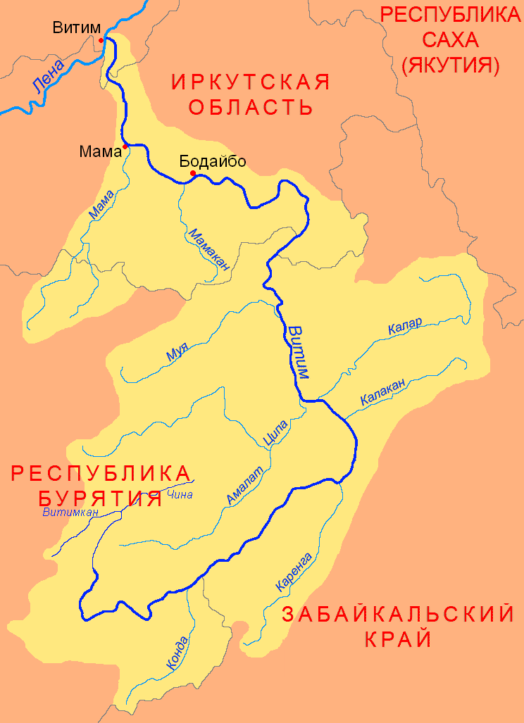
The Kuanda (), also known as Konda, is a river in Zabaykalsky Krai, southern East Siberia, Russia. It is long, and has a drainage basin of . The river flows across sparsely inhabited areas of the Kalarsky District.Google Earth Course The Kuanda is a right tributary of the Vitim. Its sources are in lake Leprindokan at the feet of the Kalar Range, one of the subranges of the Stanovoy Highlands. The river flows in a roughly western direction in a narrow valley across mountainous terrain. Then the valley widens and the river flows within a to wide tectonic basin. Its floodplain is swampy. Downstream from the mouth of the Namarakit, it flows through a narrow gorge with steep over high banks. Finally it meets the right bank of the Vitim from its mouth in the Lena. The confluence of the Kuanda is just a little downstream from the mouth of the Muya in the opposite bank of the Vitim. Tributaries The longest tributaries of the Kuanda are the long Syulban (Сюльбан) an ... [...More Info...] [...Related Items...] OR: [Wikipedia] [Google] [Baidu] |
Vitim (river)
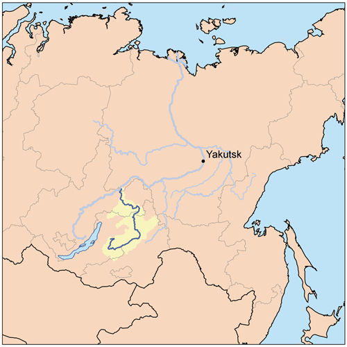
The Vitim (; , ; , ; Buryat language, Buryat and , ''Vitim'') is a major tributary of the Lena (river), Lena. Its Source (river or stream), source is east of Lake Baikal, at the confluence of rivers Vitimkan from the west and China from the east. The Vitim flows first south, bends eastwards and then northward in the Vitim Plateau. Then it flows north through the Stanovoy Highlands and the town of Bodaybo. Including river Vitimkan, its western source, it is long, and has a drainage basin of .Витим (река в Бурят. АССР) Great Soviet Encyclopedia It is navigable from the Lena to Bodaybo. Upstream, tugs can haul barges as far as the Baikal Amur Mainline (BAM), but this is becoming rare. The Vitim is an excellent place for adventure rafting, but is rarely ... [...More Info...] [...Related Items...] OR: [Wikipedia] [Google] [Baidu] |
Muya (river)
The Muya () is a left tributary of the Vitim in Buryatia, Russia. It is long and has a drainage basin of . The area through which the river flows is sparsely populated, the only settlement on the river being Taksimo, with the village of Ust-Muya located where the river flows into the Vitim, nearly opposite from the mouth of the Kuanda in the facing bank. The Muya is navigable for small craft from the Vitim around to Taksimo. The Muya has lent its name to a number of other geographic features, including the Northern Muya Range, the Southern Muya Range, the Muya-Kuanda Depression, as well as the local Muya District. Tributaries The longest tributary of the Muya is the long Muyakan on the left. See also *List of rivers of Russia Russia can be divided into a European and an Asian part. The dividing line is generally considered to be the Ural Mountains. The European part is drained into the Arctic Ocean, Baltic Sea, Black Sea, and Caspian Sea. The Asian part is drain ... [...More Info...] [...Related Items...] OR: [Wikipedia] [Google] [Baidu] |
Kalar Range
The Kalar Range () is a mountain range in Zabaykalsky Krai and the NW end of Amur Oblast, Russian Federation. The highest point of the range is high Skalisty Golets. Google Earth The range is part of the Udokan Ore Region that includes the Kodar and Udokan ranges.Udokan Ore Region / '':'' in 30 vols. / Ch. ed. A.M. Prokhorov. - 3rd ed. - M. Soviet Encyclopedia, 1969-1978. History Located in a desolate area, the Kalar Range was first described and roughly put on the map in 1857 by A.F. Usoltsev, Lieutenant of the[...More Info...] [...Related Items...] OR: [Wikipedia] [Google] [Baidu] |
List Of Rivers Of Russia
Russia can be divided into a European and an Asian part. The dividing line is generally considered to be the Ural Mountains. The European part is drained into the Arctic Ocean, Baltic Sea, Black Sea, and Caspian Sea. The Asian part is drained into the Arctic Ocean and the Pacific Ocean. Notable rivers of Russia in Europe are the Volga (which is the longest river in Europe), Pechora, Don, Kama, Oka and the Northern Dvina, while several other rivers originate in Russia but flow into other countries, such as the Dnieper (flowing through Russia, then Belarus and Ukraine and into the Black Sea) and the Western Dvina (flowing through Russia, then Belarus and Latvia into the Baltic Sea). In Asia, important rivers are the Ob, the Irtysh, the Yenisei, the Angara, the Lena, the Amur, the Yana, the Indigirka, and the Kolyma. In the list below, the rivers are grouped by the seas or oceans into which they flow. Rivers that flow into other rivers are ordered by the proximit ... [...More Info...] [...Related Items...] OR: [Wikipedia] [Google] [Baidu] |
Sentinel-2
Sentinel-2 is an Earth observation mission from the Copernicus Programme that acquires optical imagery at high spatial resolution (10 m to 60 m) over land and coastal waters. The mission's Sentinel-2A and Sentinel-2B satellites were joined in orbit in 2024 by a third, Sentinel-2C, and in the future by Sentinel-2D, eventually replacing the A and B satellites, respectively. The mission supports services and applications such as agricultural monitoring, emergencies management, land cover classification, and water quality. Sentinel-2 has been developed and is being operated by the European Space Agency. The satellites were manufactured by a consortium led by Airbus Defence and Space in Friedrichshafen, Germany. Overview The Sentinel-2 mission includes: * Multispectral image, Multi-spectral data with 13 bands in the Visible spectrum, visible, Infrared#Regions within the infrared, near infrared, and Infrared#Regions within the infrared, short wave infrared part of the Electromagnetic ... [...More Info...] [...Related Items...] OR: [Wikipedia] [Google] [Baidu] |
South Siberian System
The South Siberian Mountains () are one of the largest mountain systems in North Asia. The total area of the system of mountain ranges is more than 1.5 million km². The South Siberian Mountains are located in the Siberian and Far Eastern Federal Districts of Russia, as well as partly in Mongolia. The territory of the mountain system is one of the Great Russian Regions. Geography The system is composed of a number of ranges aligned in an east–west direction stretching for almost . Part of them are near the border with Mongolia and China, while others rise further north. To the south the South Siberian ranges merge with the Mongolian and Chinese mountain chains and plateaus. In the west lies the Dzungarian Basin and to the east the Mongolian Plateau. To the north the South Siberian Mountains merge with the West Siberian Lowland and the Central Siberian Plateau, both on the Russian side. To the southeast the Baikal Range is separated from the Eastern Sayan by the Baikal Rift ... [...More Info...] [...Related Items...] OR: [Wikipedia] [Google] [Baidu] |
Federal Subject
The federal subjects of Russia, also referred to as the subjects of the Russian Federation () or simply as the subjects of the federation (), are the administrative division, constituent entities of Russia, its top-level political divisions. According to the Constitution of Russia, the federation consists of republics of Russia, republics, krais of Russia, krais, oblasts of Russia, oblasts, federal cities of Russia, cities of federal importance, an Jewish Autonomous Oblast, autonomous oblast, and autonomous okrugs of Russia, autonomous okrugs, all of which are equal subjects of the federation. Every federal subject has its own governor (Russia), head, a regional parliaments of Russia, parliament, and a constitutional court. Each subject has its own constitution or charter and legislation, although the authority of these organs differ. Subjects have equal rights in relations with federal government bodies. The subjects have equal representation – two delegates each – in ... [...More Info...] [...Related Items...] OR: [Wikipedia] [Google] [Baidu] |
Zabaykalsky Krai
Zabaykalsky Krai is a federal subjects of Russia, federal subject of Russia (a krai), located in the Russian Far East. Its administrative center is Chita, Zabaykalsky Krai, Chita. As of the Russian Census (2010), 2010 Census, the population was 1,107,107. The krai was created on 1 March 2008, as a result of a merger of Chita Oblast and Agin-Buryat Autonomous Okrug after a referendum held on the issue on 11 March 2007. In 2018, the krai became part of the Far Eastern Federal District. Geography The krai is located within the historical region of Transbaikalia (Dauria) and has extensive international borders with China (Inner Mongolia and Heilongjiang) (998 km) and Mongolia (Dornod Province, Khentii Province and Selenge Province) (868 km); its internal borders are with Irkutsk Oblast and Amur Oblast, as well as with Buryatia and the Sakha Republic. The Khentei-Daur Highlands are located at the southwestern end. The Ivan-Arakhley Lake System is a group of lakes lying wes ... [...More Info...] [...Related Items...] OR: [Wikipedia] [Google] [Baidu] |
Drainage Basin
A drainage basin is an area of land in which all flowing surface water converges to a single point, such as a river mouth, or flows into another body of water, such as a lake or ocean. A basin is separated from adjacent basins by a perimeter, the drainage divide, made up of a succession of elevated features, such as ridges and hills. A basin may consist of smaller basins that merge at river confluences, forming a hierarchical pattern. Other terms for a drainage basin are catchment area, catchment basin, drainage area, river basin, water basin, and impluvium. In North America, they are commonly called a watershed, though in other English-speaking places, " watershed" is used only in its original sense, that of the drainage divide line. A drainage basin's boundaries are determined by watershed delineation, a common task in environmental engineering and science. In a closed drainage basin, or endorheic basin, rather than flowing to the ocean, water converges toward the ... [...More Info...] [...Related Items...] OR: [Wikipedia] [Google] [Baidu] |
Kalarsky District
Kalarsky District () is an administrativeRegistry of the Administrative-Territorial Units and the Inhabited Localities and municipalLaw #316-ZZK district (raion), one of the thirty-one in Zabaykalsky Krai, Russia. It is located in the north of the krai, and borders with Tungokochensky District and Tungiro-Olyokminsky District in the south. The area of the district is . Its administrative center is the rural locality (a '' selo'') of Chara. Population: 9,785 ( 2002 Census); The population of Chara accounts for 21.0% of the district's total population. History The district was established on September 2, 1938. Geography It is the northernmost district of Transbaikalia. The relief is mostly mountainous and includes the Kodar Range, with the highest point of Transbaikalia, Peak BAM, as well as the Udokan Range, Kalar Range and part of the Patom Highlands, among others. There are also vast intermontane basin Intermontane is a physiographic adjective formed from the ... [...More Info...] [...Related Items...] OR: [Wikipedia] [Google] [Baidu] |
Google Earth
Google Earth is a web mapping, web and computer program created by Google that renders a 3D computer graphics, 3D representation of Earth based primarily on satellite imagery. The program maps the Earth by superimposition, superimposing satellite images, aerial photography, and geographic information system, GIS data onto a 3D globe, allowing users to see cities and landscapes from various angles. Users can explore the globe by entering addresses and coordinates, or by using a Computer keyboard, keyboard or computer mouse, mouse. The program can also be downloaded on a smartphone or Tablet computer, tablet, using a touch screen or stylus to navigate. Users may use the program to add their own data using Keyhole Markup Language and upload them through various sources, such as forums or blogs. Google Earth is able to show various kinds of images overlaid on the surface of the Earth and is also a Web Map Service client. In 2019, Google revealed that Google Earth covers more than 97 ... [...More Info...] [...Related Items...] OR: [Wikipedia] [Google] [Baidu] |


