|
Kombolcha
Kombolcha () is a town and district in north-central Ethiopia. Located in the Debub Wollo Zone of the Amhara Region, it has a latitude and longitude of with an elevation between 1842 and 1915 meters above sea level. Some guide books describe Kombolcha as the twin town of Dessie which lies some to the northwest. History Origins Tadesse Tamrat records that archeologists discovered "some remains of Christian settlements", dated to the late first millennium of the current era. 19th century When the missionary Johann Ludwig Krapf was led as a prisoner from Adare Bille's capital to the Teledere House in April 1843 he had passed through Kombolcha, which he described as a village near the source of the Borkana River. 20th century Kombolcha was described during the Italian occupation as having postal and telephone service, a clinic, a general store, a barrack village of the A.A.S.S., as well as other improvements intended for Italians. [...More Info...] [...Related Items...] OR: [Wikipedia] [Google] [Baidu] |
Awash–Weldiya Railway
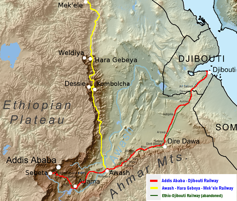
The Awash–Weldiya Railway is a standard gauge railway under construction, that will serve as a northward extension of the new Rail transport in Ethiopia, Ethiopian National Railway Network. The railroad's primary purpose is to connect the north of Ethiopia with the Addis Ababa–Djibouti Railway at the Awash, Ethiopia, Awash junction and therefore connecting it with the world economy through the Port of Djibouti and also with the southern parts of Ethiopia with its capital, Addis Ababa. The 392 km Awash–Weldiya Railway clearly is of strategic significance. It connects the whole north of Ethiopia with almost one-third of the Ethiopian population with the Addis Ababa–Djibouti Railway and with Ethiopia's lifeline, the port of Djibouti. Also, several large cities of Amhara Region are directly served by the Railway and the railway will connect Ethiopian industrial centers like Kombolcha with the world. Route and description The railway bypasses the up to 1200 metres de ... [...More Info...] [...Related Items...] OR: [Wikipedia] [Google] [Baidu] |
Kombolcha Massacre
The Kombolcha massacre was the mass extrajudicial and summary execution of over 100 ethnic Amhara civilian youths by the Tigray Defense Forces in South Wollo, in the Amhara Region of Ethiopia. Bodies of the victims were set on fire at a business compound in the town. Kombolcha was described as a key warring location and is found on the A2 highway leading into Addis Ababa, where the Tigrayan forces were advancing to the capital. Looting of aid, and private and public properties was also reported. Kombolcha town is the industrial hub of the Amhara region. Background The TPLF was the ruling party of Ethiopia that ruled the country for 27 years. Regime changes occurred in 2018 in which the TPLF lost control of federal positions while holding power in the Tigray Region. The power struggle between Abiy Ahmed’s regime and the TPLF led to the Tigray War that started after the Ethiopian military's Northern Command was attacked by TPLF in November 2020. As the war prolonged, the ... [...More Info...] [...Related Items...] OR: [Wikipedia] [Google] [Baidu] |
Amhara Region
The Amhara Region (), officially the Amhara National Regional State (), is a Regions of Ethiopia, regional state in northern Ethiopia and the homeland of the Amhara people, Amhara, Awi people, Awi, Xamir people, Xamir, Argobba people, Argobba, and Qemant people, Qemant people. Its capital is Bahir Dar which is the seat of the Government of Amhara Region, Regional Government of Amhara. Amhara is the site of the largest inland body of water in Ethiopia, Lake Tana (which is the source of the Blue Nile), and Semien Mountains National Park (which includes Ras Dashan, the highest point in Ethiopia). Amhara is bordered by Sudan to the west and northwest and by other the regions of Ethiopia: Tigray Region, Tigray to the north, Afar Region, Afar to the east, Benishangul-Gumuz Region, Benishangul-Gumuz to the west and southwest, and Oromia to the south. Towns and cities in Amhara include: Bahir Dar, Dessie, Gondar, Gonder, Debre Birhan, Debre Tabor, Kombolcha, Weldiya, Debre Markos, Soqota, ... [...More Info...] [...Related Items...] OR: [Wikipedia] [Google] [Baidu] |
Dessie
Dessie (; also spelled Dese or Dessye) is a town in north-central Ethiopia. Located in the South Wollo Zone of the Amhara Region, it sits at a latitude and longitude of , with an elevation between 2,470 and 2,550 metres above sea level. Dessie is 400 km to the north of the capital Addis Ababa. It has a population of more than 200,000 people in over 30 wards. History Medieval history Prior to Dessie's foundation, the major settlement in this area was Wasal, mentioned in an early 16th-century Italian itinerary. 19th century Dessie was founded by Emperor Yohannes IV who was camping in the highlands to the west of the Chefa Valley in 1882 on an expedition to forcefully convert the Muslims who lived in the region to Christianity. As he was looking for a place to centralize his power in Wollo, he stayed overnight in a pre-existing town that is now contained within Dessie. While there, he spotted a comet. He was so impressed by the sight of it that he interpreted it to ... [...More Info...] [...Related Items...] OR: [Wikipedia] [Google] [Baidu] |
Ethiopia
Ethiopia, officially the Federal Democratic Republic of Ethiopia, is a landlocked country located in the Horn of Africa region of East Africa. It shares borders with Eritrea to the north, Djibouti to the northeast, Somalia to the east, Kenya to the south, South Sudan to the west, and Sudan to the northwest. Ethiopia covers a land area of . , it has around 128 million inhabitants, making it the List of countries and dependencies by population, thirteenth-most populous country in the world, the List of African countries by population, second-most populous in Africa after Nigeria, and the most populous landlocked country on Earth. The national capital and largest city, Addis Ababa, lies several kilometres west of the East African Rift that splits the country into the African Plate, African and Somali Plate, Somali tectonic plates. Early modern human, Anatomically modern humans emerged from modern-day Ethiopia and set out for the Near East and elsewhere in the Middle Paleolithi ... [...More Info...] [...Related Items...] OR: [Wikipedia] [Google] [Baidu] |
Debub Wollo Zone
South Wollo (Amharic: ደቡብ ወሎ) is a zone in the Amhara Region of Ethiopia. It acquired its name from the former province of Wollo. South Wollo is bordered on the south by North Shewa and the Oromia Special Zone (Amhara), on the west by East Gojjam, on the northwest by South Gondar, on the north by North Wollo, on the northeast by Afar Region, and on the east by the Oromia Special Zone and the Argobba special woreda. Its highest point is Mount Tabor in Amhara Sayint, 4247 meter above sea level. Cities in South Wollo include Kombolcha, Hayq, Dessie, Wuchale and Wurgessa. On 24 August 2009 Zonal authorities announced that approximately 540 safe water units were constructed during the past Ethiopian budget year at a cost of over 23 million birr, while another 878 units were repaired. This has improved the access to safe water from 51% to 61% of the Zone's inhabitants. Demographics Based on the 2007 Census conducted by the Central Statistical Agency of Ethiopia ( ... [...More Info...] [...Related Items...] OR: [Wikipedia] [Google] [Baidu] |
South Wollo Zone
South Wollo ( Amharic: ደቡብ ወሎ) is a zone in the Amhara Region of Ethiopia. It acquired its name from the former province of Wollo. South Wollo is bordered on the south by North Shewa and the Oromia Special Zone (Amhara), on the west by East Gojjam, on the northwest by South Gondar, on the north by North Wollo, on the northeast by Afar Region, and on the east by the Oromia Special Zone and the Argobba special woreda. Its highest point is Mount Tabor in Amhara Sayint, 4247 meter above sea level. Cities in South Wollo include Kombolcha, Hayq, Dessie, Wuchale and Wurgessa. On 24 August 2009 Zonal authorities announced that approximately 540 safe water units were constructed during the past Ethiopian budget year at a cost of over 23 million birr, while another 878 units were repaired. This has improved the access to safe water from 51% to 61% of the Zone's inhabitants. Demographics Based on the 2007 Census conducted by the Central Statistical Agency of Et ... [...More Info...] [...Related Items...] OR: [Wikipedia] [Google] [Baidu] |
Borkana River
Borkana River is a river of central Ethiopia. A left tributary of the Awash. Johann Ludwig Krapf records that it was called "Tshaffa" by the local Oromo people. (London, 1843), p. 83 See also *Rivers of Ethiopia
[...More Info...] [...Related Items...] OR: [Wikipedia] [Google] [Baidu] |
Kebeles
A ward (; ; ) is the smallest administrative unit of Ethiopia: a ward, a neighbourhood or a localized and delimited group of people. Somali word that has meaning of collected people where water is fairly sufficient and available to prolongue their pastoralist livelihood. It is part of a district, itself usually part of a zone, which in turn are grouped into one of the regions or two chartered cities that comprise the Federal Democratic Republic of Ethiopia. Each ward consists of at least 500 families, or the equivalent of 3,500 to 4,000 persons. There is at least one in every town with more than 2,000 population. A district's representative had jurisdiction over to ward. The ward, also referred to as a peasant association, was created by the Derg in 1975 to promote development and to manage land reform; they became a key element that the rival Ethiopian People's Revolutionary Party and MEISON fought each other, and the ruling Derg, to control during the Ethiopian Red Terror. The ... [...More Info...] [...Related Items...] OR: [Wikipedia] [Google] [Baidu] |
Central Statistical Agency (Ethiopia)
The Central Statistical Agency, also known as the Ethiopian Statistical Service (ESS; Amharic: የኢትዮጵያ ስታቲስቲክስ አገልግሎት), is an Ethiopian government agency designated to provide all surveys and censuses for that country used to monitor economic and social growth, as well as to act as an official training center in that field. It is part of the Ethiopian Ministry of Finance and Economic Development (Ethiopia), Ministry of Finance and Economic Development. The Director General of the ESS is Beker Shale (Ph.D.). Before 9 March 1989 the ESS was known as the Central Statistical Office (CSO). The ESS has 25 branch offices. Besides the capital city of Addis Ababa, the cities and towns with offices are: Ambo, Ethiopia, Ambo, Arba Minch, Chiro (town), Chiro, Asayita, Assosa, Awasa, Bahir Dar, Debre Berhan, Dessie, Dire Dawa, Gambela, Ethiopia, Gambela, Goba, Gondar, Harar, Hosaena, Inda Selassie, Jijiga, Jimma, Mek'ele, Mizan Teferi, Adama, Negele Borana, ... [...More Info...] [...Related Items...] OR: [Wikipedia] [Google] [Baidu] |
The Globe And Mail
''The Globe and Mail'' is a Newspapers in Canada, Canadian newspaper printed in five cities in Western Canada, western and central Canada. With a weekly readership of more than 6 million in 2024, it is Canada's most widely read newspaper on weekdays and Saturdays, although it falls slightly behind the ''Toronto Star'' in overall weekly circulation because the ''Star'' publishes a Sunday edition, whereas the ''Globe'' does not. ''The Globe and Mail'' is regarded by some as Canada's "newspaper of record". ''The Globe and Mail''s predecessors, ''The Globe (Toronto newspaper), The Globe'' and ''The Daily Mail and Empire'' were both established in the 19th century. The former was established in 1844, while the latter was established in 1895 through a merger of ''The Toronto Mail'' and ''The Empire (Toronto), The Empire''. In 1936, ''The Globe'' and ''The Mail and Empire'' merged to form ''The Globe and Mail''. The newspaper was acquired by FP Publications in 1965, who later sold the p ... [...More Info...] [...Related Items...] OR: [Wikipedia] [Google] [Baidu] |


