|
Kola Peninsula
The Kola Peninsula (; ) is a peninsula in the extreme northwest of Russia, and one of the largest peninsulas of Europe. Constituting the bulk of the territory of Murmansk Oblast, it lies almost completely inside the Arctic Circle and is bordered by the Barents Sea to the north and by the White Sea to the east and southeast. The city of Murmansk, the most populous settlement on the peninsula, has a population of roughly 270,000 residents. While humans had already settled in the north of the peninsula in the 7th–5th millennium BC, the rest of its territory remained uninhabited until the 3rd millennium BC, when various peoples started to arrive from the south. By the 1st millennium CE only the Sami people remained. This changed in the 12th century, when Russian Pomors discovered the peninsula's rich resources of game and fish. Soon after, the Pomors were followed by the tribute collectors from the Novgorod Republic, and the peninsula gradually became a part of the Novgorodian la ... [...More Info...] [...Related Items...] OR: [Wikipedia] [Google] [Baidu] |
Murmansk Oblast
Murmansk Oblast is a federal subjects of Russia, federal subject (an oblast) of Russia, located in the northwestern part of the country, with a total land area of . Its only internal border is the Republic of Karelia to the south, and it is bordered internationally by Finland to the west and Norway to the northwest and the Barents Sea lies to the north and White Sea lies to the south and east. Its administrative center is the types of inhabited localities in Russia, city of Murmansk. As of the Russian Census (2010), 2010 Census, its population was 795,409, but at the 2021 Census this had declined to 667,744. Geography Geographically, Murmansk Oblast is located mainly on the Kola Peninsula almost completely north of the Arctic Circle''2007 Atlas of Murmansk Oblast'', p. 2 and is a part of the larger Sápmi, Sápmi (Lapland) region that spans over four countries.Ratcliffe, p. 1 The oblast borders with the Republic of Karelia in Russia in the south, Lapland, Finland, L ... [...More Info...] [...Related Items...] OR: [Wikipedia] [Google] [Baidu] |
Apatite
Apatite is a group of phosphate minerals, usually hydroxyapatite, fluorapatite and chlorapatite, with high concentrations of Hydroxide, OH−, Fluoride, F− and Chloride, Cl− ion, respectively, in the crystal. The formula of the admixture of the three most common Endmember (mineralogy), endmembers is written as Calcium, Ca10(Phosphate, PO4)6(OH,F,Cl)2, and the crystal unit cell formulae of the individual minerals are written as Ca10(PO4)6(OH)2, Ca10(PO4)6F2 and Ca10(PO4)6Cl2. The mineral was named apatite by the German geologist Abraham Gottlob Werner in 1786, although the specific mineral he had described was reclassified as fluorapatite in 1860 by the German mineralogist Karl Friedrich August Rammelsberg. Apatite is often mistaken for other minerals. This tendency is reflected in the mineral's name, which is derived from the Greek word ἀπατάω (apatáō), which means ''to deceive''. Geology Apatite is very common as an accessory mineral in igneous and metamorphic roc ... [...More Info...] [...Related Items...] OR: [Wikipedia] [Google] [Baidu] |
Baltic Shield
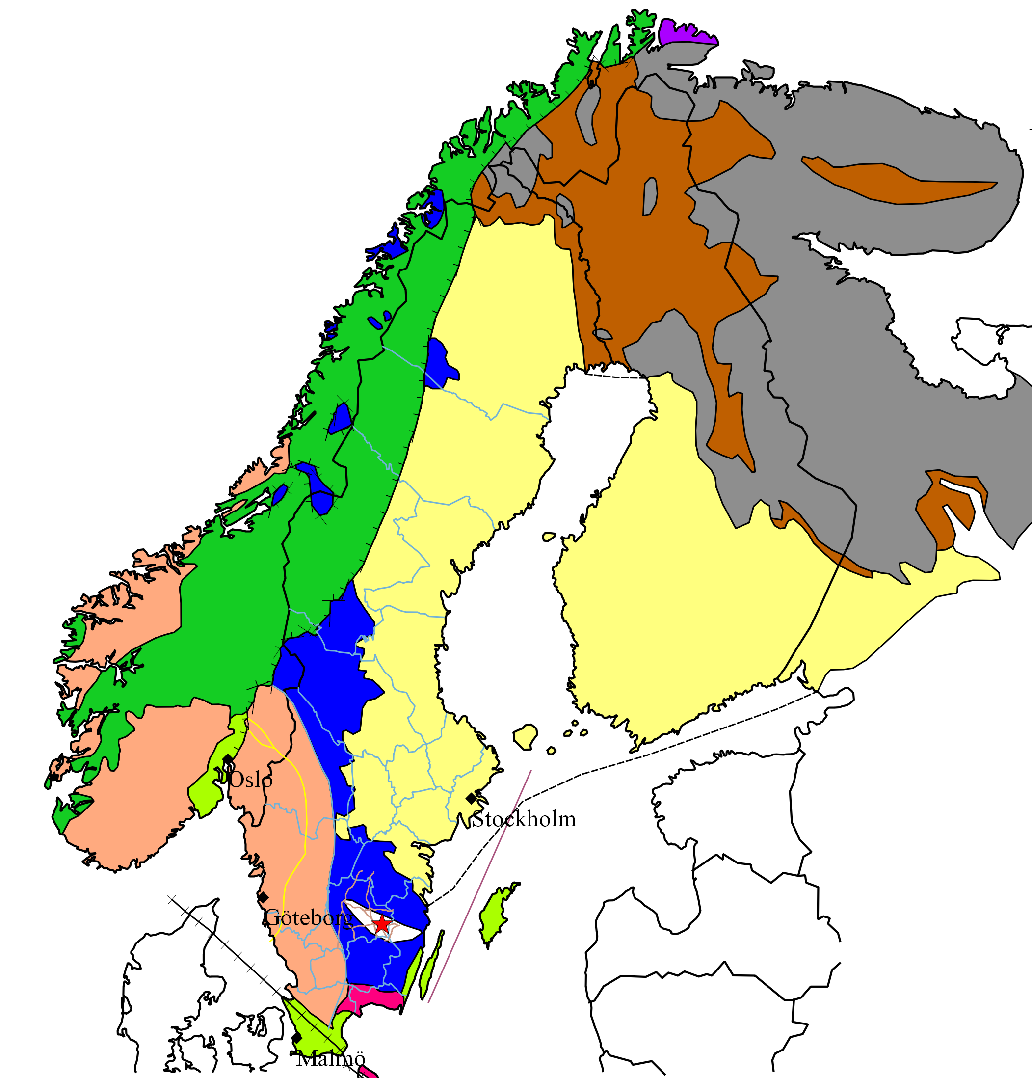
The Baltic Shield (or Fennoscandian Shield) is a segment of the Earth's crust belonging to the East European craton, East European Craton, representing a large part of Fennoscandia, northwestern Russia and the northern Baltic Sea. It is composed mostly of Archean and Proterozoic gneisses and greenstone belts, greenstone which have undergone numerous deformations through plate tectonics, tectonic activity. It contains the oldest rocks of the European continent with a thickness of 250–300 km. The Baltic Shield is divided into five ''provinces'': the Svecofennian orogeny, Svecofennian and Sveconorwegian orogeny, Sveconorwegian (or Southwestern gneiss) provinces in Fennoscandia, and the Karelian, Belomorian Province, Belomorian and Kola Province, Kola provinces in Russia. The latter three are divided further into several ''blocks'' and ''complexes'' and contain the oldest of the rocks, at 3100–2500 annum, Ma (million years) old. The youngest rocks belong to the Sveconorwegian ... [...More Info...] [...Related Items...] OR: [Wikipedia] [Google] [Baidu] |
Kola Superdeep Borehole
The Kola Superdeep Borehole SG-3 () is the deepest human-made hole on Earth (since 1979), which attained maximum true vertical depth of in 1989. It is the result of a scientific drilling effort to penetrate as deeply as possible into the Earth's crust conducted by the Soviet Union in the Pechengsky District of the Kola Peninsula, near the Russian border with Norway. SG (СГ) is a Russian designation for a set of superdeep () boreholes conceived as part of a Soviet scientific research programme of the 1960s, 1970s and 1980s. Aralsor SG-1 (in the Pre-Caspian Basin of west Kazakhstan) and Biyikzhal SG-2 (in Krasnodar Krai), both less than deep, preceded Kola SG-3, which was originally intended to reach deep. Drilling at Kola SG-3 began in 1970 using the '' Uralmash-4E'', and later the ''Uralmash-15000'' series drilling rig. A total of five boreholes were drilled, two branching from a central shaft and two from one of those branches. In addition to being the deepest hu ... [...More Info...] [...Related Items...] OR: [Wikipedia] [Google] [Baidu] |
Kandalaksha Gulf
The Kandalaksha Gulf (, , ) is located in the Republic of Karelia, and Murmansk Oblast in northwestern Russia. Forming the north-western corner of the White Sea, it is one of four large bays and gulfs of this sea, the others being the Onega Bay (south-west), the Dvina Bay (south), and the Mezen Bay (south east). The Kola Peninsula lies north of the Kandalaksha Gulf. The city of Kandalaksha is located at the northern tip of the gulf; the new oil port Vitino, some 10 km to the south. There are hundreds of Skerry, skerries in the gulf. The gulf is shallow, reaching 300 meters on its western side. In 1976, the upper reaches of the gulf were designated a Ramsar wetland of international importance, notably as a breeding ground for migratory waterfowl such as the sea duck. Kandalaksha Nature Reserve (:ru:Кандалакшский заповедник, Кандалакшский заповедник) includes parts of the coastline and many of the islands in the gulf. It is one of ... [...More Info...] [...Related Items...] OR: [Wikipedia] [Google] [Baidu] |
Common Eider
The common eider (pronounced ) (''Somateria mollissima''), also called St. Cuthbert's duck or Cuddy's duck, is a large ( in body length) sea-duck that is distributed over the northern coasts of Europe, North America and eastern Siberia. It breeds in Arctic and some northern temperate regions, but winters somewhat farther south in temperate zones, when it can form large flocks on coastal waters. It can fly at speeds up to . The eider's nest is built close to the sea and is lined with eiderdown, plucked from the female's breast. This soft and warm lining has long been harvested for filling pillows and quilts, but in more recent years has been largely replaced by down from domestic farm-geese and synthetic alternatives. Although eiderdown pillows or quilts are now a rarity—typically being marketed as luxury goods—eiderdown harvesting continues and is sustainable, as it can be done after the ducklings leave the nest with no harm to the birds. Taxonomy The common eider was for ... [...More Info...] [...Related Items...] OR: [Wikipedia] [Google] [Baidu] |
Kandalaksha Nature Reserve
Kandalaksha Nature Reserve () (also Kandalakshsky) is a Russian 'zapovednik' (strict ecological reserve) on the south shore of Kandalaksha Bay in the Murmansk and Karelia regions on the opening to the White Sea. The reserve also includes two small sectors on the northern coast of the Kola peninsula on the Barents Sea; notably, the warm Atlantic current causes the northern sectors on the Barents Sea to be warmer than the more southerly White Sea sectors. Over 550 islands are covered in the boundaries of the reserve. It is one of the oldest nature reserves in Russia, created in 1932 to protect the marine habitats and waterfowl of the region, particularly the eider. The reserve is situated in the Kandalakshsky District, Kolsky District, and Lovozersky District of Murmansk Oblast. The nearest city, Kandalaksha, is at the northwest entrance to the Kandalaksha Gulf, about 5 km from the nearest point in the reserve. Since 1976, the reserve has been part of the Ramsar wetland site ... [...More Info...] [...Related Items...] OR: [Wikipedia] [Google] [Baidu] |
Atlantic Salmon
The Atlantic salmon (''Salmo salar'') is a species of ray-finned fish in the family Salmonidae. It is the third largest of the Salmonidae, behind Hucho taimen, Siberian taimen and Pacific Chinook salmon, growing up to a meter in length. Atlantic salmon are found in the northern Atlantic Ocean and in rivers that flow into it. Most populations are anadromous, hatching in streams and rivers but moving out to sea as they grow where they mature, after which the adults seasonally move upstream again to spawn. When the mature fish re-enter rivers to spawn, they change in colour and appearance. Some populations of this fish only migrate to large lakes, and are "landlocked", spending their entire lives in freshwater. Such populations are found throughout the range of the species. Unlike Pacific species of salmon, ''S. salar'' is iteroparous, which means it can survive spawning and return to sea to repeat the process again in another year with 5–10% returning to the sea to spawn again ... [...More Info...] [...Related Items...] OR: [Wikipedia] [Google] [Baidu] |
Permafrost
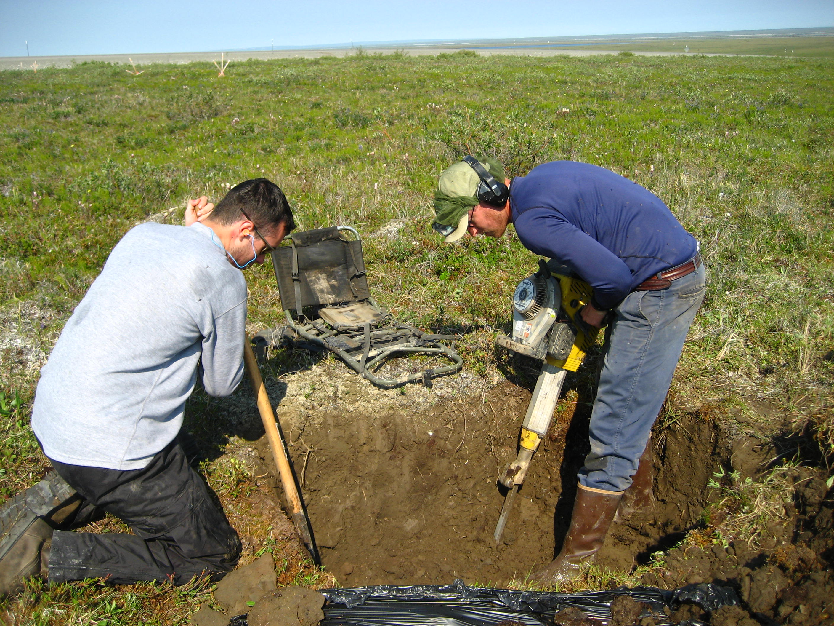
Permafrost () is soil or underwater sediment which continuously remains below for two years or more; the oldest permafrost has been continuously frozen for around 700,000 years. Whilst the shallowest permafrost has a vertical extent of below a meter (3 ft), the deepest is greater than . Similarly, the area of individual permafrost zones may be limited to narrow mountain summits or extend across vast Arctic regions. The ground beneath glaciers and ice sheets is not usually defined as permafrost, so on land, permafrost is generally located beneath a so-called active layer of soil which freezes and thaws depending on the season. Around 15% of the Northern Hemisphere or 11% of the global surface is underlain by permafrost, covering a total area of around . This includes large areas of Alaska, Canada, Greenland, and Siberia. It is also located in high mountain regions, with the Tibetan Plateau being a prominent example. Only a minority of permafrost exists in the Southern Hemi ... [...More Info...] [...Related Items...] OR: [Wikipedia] [Google] [Baidu] |
Tundra
In physical geography, a tundra () is a type of biome where tree growth is hindered by frigid temperatures and short growing seasons. There are three regions and associated types of tundra: #Arctic, Arctic, Alpine tundra, Alpine, and #Antarctic, Antarctic. Tundra vegetation is composed of dwarf shrubs, Cyperaceae, sedges, Poaceae, grasses, mosses, and lichens. Scattered trees grow in some tundra regions. The ecotone (or ecological boundary region) between the tundra and the forest is known as the tree line or timberline. The tundra soil is rich in nitrogen and phosphorus. The soil also contains large amounts of biomass and decomposed biomass that has been stored as methane and carbon dioxide in the permafrost, making the tundra soil a carbon sink. As global warming heats the ecosystem and causes soil thawing, the permafrost carbon cycle accelerates and releases much of these soil-contained greenhouse gases into the atmosphere, creating Climate change feedback, a feedback cycle t ... [...More Info...] [...Related Items...] OR: [Wikipedia] [Google] [Baidu] |
Taiga
Taiga or tayga ( ; , ), also known as boreal forest or snow forest, is a biome characterized by coniferous forests consisting mostly of pines, spruces, and larches. The taiga, or boreal forest, is the world's largest land biome. In North America, it covers most of inland Canada, Alaska, and parts of the northern contiguous United States. In Eurasia, it covers most of Sweden, Finland, much of Russia from Karelia in the west to the Pacific Ocean (including much of Siberia), much of Norway and Estonia, some of the Scottish Highlands, some lowland/coastal areas of Iceland, and areas of northern Kazakhstan, northern Mongolia, and northern Japan (on the island of Hokkaido). The principal tree species, depending on the length of the growing season and summer temperatures, vary across the world. The taiga of North America is mostly spruce; Scandinavian and Finnish taiga consists of a mix of spruce, pines and birch; Russian taiga has spruces, pines and larches depending on the reg ... [...More Info...] [...Related Items...] OR: [Wikipedia] [Google] [Baidu] |
Gulf Stream
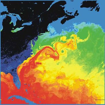
The Gulf Stream is a warm and swift Atlantic ocean current that originates in the Gulf of Mexico and flows through the Straits of Florida and up the eastern coastline of the United States, then veers east near 36°N latitude (North Carolina) and moves toward Northwest Europe as the North Atlantic Current. The process of western intensification causes the Gulf Stream to be a northward-accelerating current off the east coast of North America. Around , it splits in two, with the northern stream, the North Atlantic Drift, crossing to Northern Europe and the southern stream, the Canary Current, recirculating off West Africa. The Gulf Stream influences the climate of the coastal areas of the East Coast of the United States from Florida to southeast Virginia (near 36°N latitude), and to a greater degree, the climate of Northwest Europe. A consensus exists that the climate of Northwest Europe is warmer than other areas of similar latitude at least partially because of the stron ... [...More Info...] [...Related Items...] OR: [Wikipedia] [Google] [Baidu] |


