Kodair
   HOME


picture info

Kodair
Koderu or Kodair is a village and Tehsil, mandal headquarters in Nagar Kurnool district, Telangana, India. Geography Kodair is at coordinates 16.2667°N 78.3000°E on world map. It has an average elevation of 371 metres (1220 ft) from sea level. Kodair is a village and mandal head quarter in Nagar Kurnoor district (it was Mahbub Nagar, before district reorganization) of Telangana state, previously united Andhra Pradesh State, India. It is  km south of district headquarters Mahabubnagar, and 147 km south of the state capital, Hyderabad. Kodair Mandal is bounded by Peddakothapally Mandal to the east, Pangal Mandal to the west, Kollapur Mandal to the south, Gopalpet Mandal to the west. Nagarkurnool City, Wanaparthy City, Gadwal City, Badepalle City are the nearby cities to Kodair. Kodair consist of 35 villages and 15 Panchayats Khanapur is the smallest village, and Kodair is the largest village of all. Srisailam, Mantralayam, Nagarjunasagar, Hyderabad, ...
[...More Info...]      
[...Related Items...]     OR:     [Wikipedia]   [Google]   [Baidu]  


picture info

Nagar Kurnool District
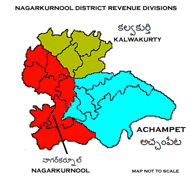
Nagarkurnool district is a district in the southern region of the Indian state of Telangana. The town of Nagarkurnool is the district headquarters. It was part of the Mahbubnagar district prior to re-organisation of districts in the state. The district shares boundaries with Nalgonda, Rangareddy, Mahabubnagar, Wanaparthy districts and with the state boundary of Andhra Pradesh with Nandyal, Narasaraopet, Palnadu and Prakasam Districts. History The Nagarkurnool district is historically, traditionally ruled by several empires in past. The evidences of monuments and inscriptions found near confluence of rivers Krishna River and Tungabhadra River reveals that it was an inhabited place since the Stone Age . Many places of this district have legendary history. The history of this district is divided into four periods, from the Badami Chalukya till the Muslim invasion. Gona Ganna Reddy was the ruled Nandi vardhamana puram by making capital.its near Village of Nagarkurnool. Gona G ...
[...More Info...]      
[...Related Items...]     OR:     [Wikipedia]   [Google]   [Baidu]  


picture info

Kollapur
Kollapur region is an area spanning the Nallamala Forest area on the banks of the river Krishna in the Nagarkurnool district, in the state of Telangana India. The Someswara, Sangameswara, and Malleswara temples are in this region, with traces of architectural treasures from the 2nd century BC. Hundreds of ancient temples are visible in the area, mainly built over 1,500 years ago. Due to similar broad roads and surrounding tree plantations, people used to refer to Kollapur as ''Telangana Mysore'' (a reference to the larger city of Mysore). Jeevan kumar yadav is scientific is going to launch 250acres of biological research institute in the year 2030 .. estimated value of the project is about 2000cr Indian currency Constituency There are five Mandals A tehsil (, also known as tahsil, taluka, or taluk) is a local unit of administrative division in some countries of South Asia. It is a subdistrict of the area within a district including the designated populated place that ser ...
[...More Info...]      
[...Related Items...]     OR:     [Wikipedia]   [Google]   [Baidu]  


picture info

States And Territories Of India
India is a federal union comprising 28 states and 8 union territories, with a total of 36 entities. The states and union territories are further subdivided into districts and smaller administrative divisions. History Pre-independence The Indian subcontinent has been ruled by many different ethnic groups throughout its history, each instituting their own policies of administrative division in the region. The British Raj The British Raj (; from Hindi language, Hindi ''rāj'': kingdom, realm, state, or empire) was the rule of the British The Crown, Crown on the Indian subcontinent; * * it is also called Crown rule in India, * * * * or Direct rule in India, * Q ... mostly retained the administrative structure of the preceding Mughal Empire. India was divided into provinces (also called Presidencies), directly governed by the British, and princely states, which were nominally controlled by a local prince or raja loyal to the British Empire, which held ''de f ...
[...More Info...]      
[...Related Items...]     OR:     [Wikipedia]   [Google]   [Baidu]  


picture info

Köppen Climate Classification
The Köppen climate classification is one of the most widely used climate classification systems. It was first published by German-Russian climatologist Wladimir Köppen (1846–1940) in 1884, with several later modifications by Köppen, notably in 1918 and 1936. Later, the climatologist Rudolf Geiger (1894–1981) introduced some changes to the classification system, which is thus sometimes called the Köppen–Geiger climate classification system. The Köppen climate classification divides climates into five main climate groups, with each group being divided based on seasonal precipitation and temperature patterns. The five main groups are ''A'' (tropical), ''B'' (arid), ''C'' (temperate), ''D'' (continental), and ''E'' (polar). Each group and subgroup is represented by a letter. All climates are assigned a main group (the first letter). All climates except for those in the ''E'' group are assigned a seasonal precipitation subgroup (the second letter). For example, ''Af'' i ...
[...More Info...]      
[...Related Items...]     OR:     [Wikipedia]   [Google]   [Baidu]  


picture info

India
India, officially the Republic of India ( Hindi: ), is a country in South Asia. It is the seventh-largest country by area, the second-most populous country, and the most populous democracy in the world. Bounded by the Indian Ocean on the south, the Arabian Sea on the southwest, and the Bay of Bengal on the southeast, it shares land borders with Pakistan to the west; China, Nepal, and Bhutan to the north; and Bangladesh and Myanmar to the east. In the Indian Ocean, India is in the vicinity of Sri Lanka and the Maldives; its Andaman and Nicobar Islands share a maritime border with Thailand, Myanmar, and Indonesia. Modern humans arrived on the Indian subcontinent from Africa no later than 55,000 years ago., "Y-Chromosome and Mt-DNA data support the colonization of South Asia by modern humans originating in Africa. ... Coalescence dates for most non-European populations average to between 73–55 ka.", "Modern human beings—''Homo sapiens''—originated in Africa. Th ...
[...More Info...]      
[...Related Items...]     OR:     [Wikipedia]   [Google]   [Baidu]  


Tehsil
A tehsil (, also known as tahsil, taluka, or taluk) is a local unit of administrative division in some countries of South Asia. It is a subdistrict of the area within a district including the designated populated place that serves as its administrative centre, with possible additional towns, and usually a number of villages. The terms in India have replaced earlier terms, such as '' pargana'' ('' pergunnah'') and '' thana''. In Andhra Pradesh and Telangana, a newer unit called mandal (circle) has come to replace the system of tehsils. It is generally smaller than a tehsil, and is meant for facilitating local self-government in the panchayat system. In West Bengal, Bihar, Jharkhand, community development blocks are the empowered grassroots administrative unit, replacing tehsils. As an entity of local government, the tehsil office ( panchayat samiti) exercises certain fiscal and administrative power over the villages and municipalities within its jurisdiction. It is the ultimate e ...
[...More Info...]      
[...Related Items...]     OR:     [Wikipedia]   [Google]   [Baidu]  


picture info

Village
A village is a clustered human settlement or community, larger than a hamlet but smaller than a town (although the word is often used to describe both hamlets and smaller towns), with a population typically ranging from a few hundred to a few thousand. Though villages are often located in rural areas, the term urban village is also applied to certain urban neighborhoods. Villages are normally permanent, with fixed dwellings; however, transient villages can occur. Further, the dwellings of a village are fairly close to one another, not scattered broadly over the landscape, as a dispersed settlement. In the past, villages were a usual form of community for societies that practice subsistence agriculture, and also for some non-agricultural societies. In Great Britain, a hamlet earned the right to be called a village when it built a church.
[...More Info...]      
[...Related Items...]     OR:     [Wikipedia]   [Google]   [Baidu]  


picture info

Climatic Regions Of India
The climate of India consists of a wide range of weather conditions across a vast geographic scale and varied topography. Based on the Köppen system, India hosts six major climatic sub types, ranging from arid deserts in the west, alpine tundra and glaciers in the north, and humid tropical regions supporting rain forests in the southwest and the island territories. Many regions have starkly different microclimates, making it one of the most climatically diverse countries in the world. The country's meteorological department follows the international standard of four seasons with some local adjustments: winter (December to February), summer (March to May), monsoon (rainy) season (June to September), and a post-monsoon period (October and November). India's geography and geology are climatically pivotal: the Thar Desert in the northwest and the Himalayas in the north work in tandem to create a culturally and economically important monsoonal regime. As Earth's highest and ...
[...More Info...]      
[...Related Items...]     OR:     [Wikipedia]   [Google]   [Baidu]