|
Kirman (Sasanian Province)
Kirman (Middle Persian: ''Kirmān'') was a Sasanian province in Late Antiquity, which corresponds to the present-day province of Kerman. The province bordered Pars in the west, Abarshahr and Sakastan in the northeast, Paradan in the east, Spahan in the north, and Mazun in the south. The capital of the province was Shiragan. The province allegedly functioned as some kind of vassal kingdom, being mostly ruled by princes from the royal family, who bore the title of Kirmanshah ("King of Kirman"). The non-royal governors of the province bore the title of ''marzban''. Name The name of the province is derived from Old Persian ''Karmāna''; the etymology of the name is debated, a popular theory is that it is related to Old Iranian ''*kṛma-'' and Middle Persian ''kerm'' ("worm"). History The province was originally part of the Parthian Empire, but was in the early 3rd-century conquered by the first Sasanian king Ardashir I (). According to the medieval Iranian historian al-Tabari, A ... [...More Info...] [...Related Items...] OR: [Wikipedia] [Google] [Baidu] |
Sasanian Empire
The Sasanian Empire (), officially Eranshahr ( , "Empire of the Iranian peoples, Iranians"), was an List of monarchs of Iran, Iranian empire that was founded and ruled by the House of Sasan from 224 to 651. Enduring for over four centuries, the length of the Sasanian dynasty's reign over ancient Iran was second only to the directly preceding Arsacid dynasty of Parthia. Founded by Ardashir I, whose rise coincided with the decline of Arsacid influence in the face of both internal and external strife, the House of Sasan was highly determined to restore the legacy of the Achaemenid Empire by expanding and consolidating the Iranian nation's dominions. Most notably, after defeating Artabanus IV of Parthia during the Battle of Hormozdgan in 224, it began competing far more zealously with the neighbouring Roman Empire than the Arsacids had, thus sparking a new phase of the Roman–Iranian Wars. This effort by Ardashir's dynasty ultimately re-established Iran as a major power of late an ... [...More Info...] [...Related Items...] OR: [Wikipedia] [Google] [Baidu] |
Ardashir I
Ardashir I (), also known as Ardashir the Unifier (180–242 AD), was the founder of the Sasanian Empire, the last empire of ancient Iran. He was also Ardashir V of the Kings of Persis, until he founded the new empire. After defeating the last Parthian Empire, Parthian King of Kings, shahanshah Artabanus IV of Parthia, Artabanus IV on the Battle of Hormozdgan, Hormozdgan plain in 224, he overthrew the Parthian Empire, Arsacid dynasty and established the Sasanian dynasty. Afterwards, Ardashir called himself ''shahanshah'' and began conquering the land that he called ''Iran (word), Eranshahr'', the realm of the Arya (Iran), Iranians. There are various historical reports about Ardashir's lineage and ancestry. According to al-Tabari's ''History of the Prophets and Kings'', Ardashir was son of Papak, son of Sasan. Another narrative recorded in Kar-Namag i Ardashir i Pabagan, ''Kar-Namag i Ardashir i Pabagan'' and Ferdowsi, Ferdowsi's ''Shahnameh'' states that Ardashir was born from the ... [...More Info...] [...Related Items...] OR: [Wikipedia] [Google] [Baidu] |
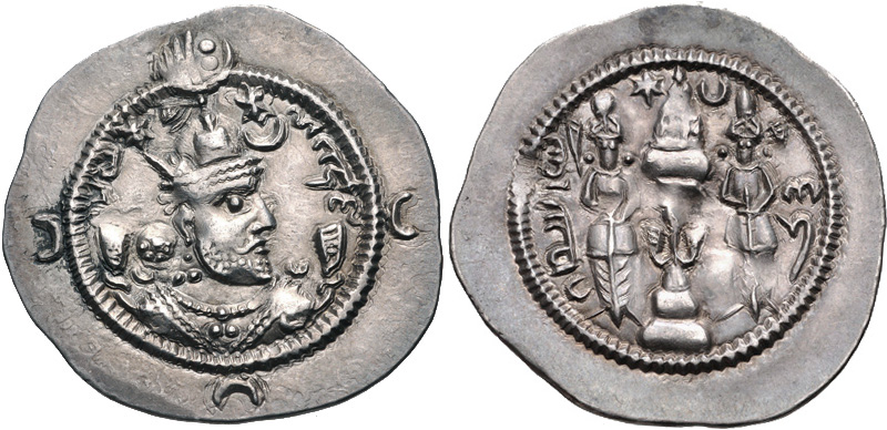
Khosrow I Coin Minted In Kirman
Khosrow (; also spelled Khusrow, Khusraw, Khusrau, Khusro, Khasru, Khosru, Chosro or Osro) may refer to: * Khosrow (name), a male given name also used as a title Iranian rulers * Khosrow I, Sasanian ruler 531–579 * Khosrow II, Sasanian ruler 590–628 * Khosrow III, Sasanian ruler 630 * Khosrow IV, Sasanian ruler 631–633 * Khosrow (son of Bahram IV), 420 * Khusrau Shah, sultan of the Ghaznavid Empire 1157–1160 * Khusrau Malik, last Sultan of the Ghaznavid Empire, 1160–1186 * Osroes I, c. 109–129 * Osroes II, c. 190 Kings of Armenia *Khosrov I of Armenia, 198–217 * Khosrov II of Armenia, c. 252 * Khosrov III the Small, 330–339 * Khosrov IV of Armenia, 387–389 Other people Given name * Khosrov of Andzev (fl. 10th century), Armenian writer * Khosrow Jahanbani (1941–2014), Iranian royal * Khusrau Khan, Sultan of Delhi for four months in 1320 * Khusrau Mirza (1587–1622), son of Mughal emperor Jahangir * Cosroe Dusi (1808–1859), Italian painter * Khosrov ... [...More Info...] [...Related Items...] OR: [Wikipedia] [Google] [Baidu] |
Mahan, Iran
Mahan () is a city in, and the capital of, Mahan District of Kerman County, Kerman province, Iran. History Mahan is well known for the tomb of the great Sufi leader Shah Ne'emat Ollah-e-Vali, as well as Shazdeh Garden (Prince Garden). The tomb of Shah Nur-eddin Nematollah Vali, poet, sage, Sufi and founder of an order of darvishes, has twin minarets covered with turquoise tiles from the bottom up to the cupola. The mausoleum was built by Ahmad Shah Kani; the rest of the building was constructed during the reigns of Shah Abbas I, Mohammad Shah Qajar and Nasser-al-Din Shah. Shah Nematallah Wali spent many years wandering through central Asia perfecting his spiritual gifts before finally settling at Mahan, twenty miles south-east of Kerman, where he passed the last twenty five years of his life. He died in 1431, having founded a Darvish order which continues to be an active spiritual force today. The central domed burial vault at Mahan, completed in 1437 was erected by A ... [...More Info...] [...Related Items...] OR: [Wikipedia] [Google] [Baidu] |
Shapur I
Shapur I (also spelled Shabuhr I; ) was the second Sasanian Empire, Sasanian King of Kings of Iran. The precise dating of his reign is disputed, but it is generally agreed that he ruled from 240 to 270, with his father Ardashir I as co-regent until the death of the latter in 242. During his co-regency, he helped his father with the conquest and destruction of the city of Hatra, whose fall was facilitated, according to Islamic tradition, by the actions of his future wife al-Nadirah. Shapur also consolidated and expanded the empire of Ardashir I, waged war against the Roman Empire, and seized its cities of Nusaybin, Nisibis and Harran, Carrhae while he was advancing as far as Roman Syria. Although he was defeated at the Battle of Resaena in 243 by Roman emperor Gordian III (), the following year he was able to win the Battle of Misiche and force the new Roman emperor Philip the Arab () to sign a favorable peace treaty that was regarded by the Romans as "a most shameful treaty". Sh ... [...More Info...] [...Related Items...] OR: [Wikipedia] [Google] [Baidu] |
Ammianus Marcellinus
Ammianus Marcellinus, occasionally anglicized as Ammian ( Greek: Αμμιανός Μαρκελλίνος; born , died 400), was a Greek and Roman soldier and historian who wrote the penultimate major historical account surviving from antiquity (preceding Procopius). Written in Latin and known as the '' Res gestae'', his work chronicled the history of Rome from the accession of Emperor Nerva in 96 to the death of Valens at the Battle of Adrianople in 378. Only the sections covering the period 353 to 378 survive. Biography Ammianus was born in the East Mediterranean, possibly in Syria or Phoenicia, around 330, into a noble family of Greek origin. Since he calls himself ''Graecus'' ( Greek), he was most likely born in a Greek-speaking area of the empire. His native language was Greek, but he also knew Latin. The surviving books of his history cover the years 353 to 378. Ammianus began his career as a military officer in the Praetorian Guard, where he gained firsthand exper ... [...More Info...] [...Related Items...] OR: [Wikipedia] [Google] [Baidu] |
Ptolemy
Claudius Ptolemy (; , ; ; – 160s/170s AD) was a Greco-Roman mathematician, astronomer, astrologer, geographer, and music theorist who wrote about a dozen scientific treatises, three of which were important to later Byzantine science, Byzantine, Islamic science, Islamic, and Science in the Renaissance, Western European science. The first was his astronomical treatise now known as the ''Almagest'', originally entitled ' (, ', ). The second is the ''Geography (Ptolemy), Geography'', which is a thorough discussion on maps and the geographic knowledge of the Greco-Roman world. The third is the astrological treatise in which he attempted to adapt horoscopic astrology to the Aristotelian physics, Aristotelian natural philosophy of his day. This is sometimes known as the ' (, 'On the Effects') but more commonly known as the ' (from the Koine Greek meaning 'four books'; ). The Catholic Church promoted his work, which included the only mathematically sound geocentric model of the Sola ... [...More Info...] [...Related Items...] OR: [Wikipedia] [Google] [Baidu] |
Greeks
Greeks or Hellenes (; , ) are an ethnic group and nation native to Greece, Greek Cypriots, Cyprus, Greeks in Albania, southern Albania, Greeks in Turkey#History, Anatolia, parts of Greeks in Italy, Italy and Egyptian Greeks, Egypt, and to a lesser extent, other countries surrounding the Eastern Mediterranean and Black Sea. They also form a significant Greek diaspora, diaspora (), with many Greek communities established around the world.. Greek colonies and communities have been historically established on the shores of the Mediterranean Sea and Black Sea, but the Greek people themselves have always been centered on the Aegean Sea, Aegean and Ionian Sea, Ionian seas, where the Greek language has been spoken since the Bronze Age.. Until the early 20th century, Greeks were distributed between the Greek peninsula, the western coast of Asia Minor, the Black Sea coast, Cappadocia in central Anatolia, Egypt, the Balkans, Cyprus, and Constantinople. Many of these regions coincided to ... [...More Info...] [...Related Items...] OR: [Wikipedia] [Google] [Baidu] |
Bam, Iran
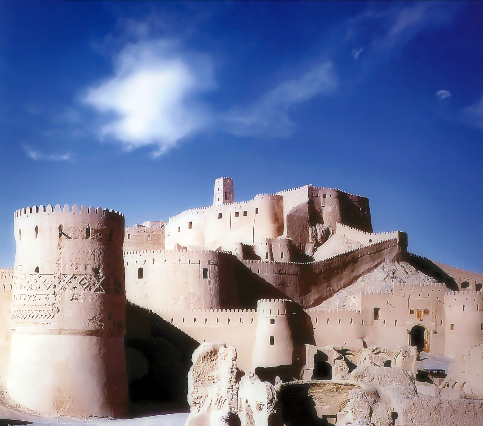
Bam () is a city in the Central District of Bam County, Kerman province, Iran, serving as capital of both the county and the district. The modern city surrounds the ancient citadel which has a history dating back to around 2,000 years ago. The citadel is a popular tourist attraction and a world heritage site. Before the 2003 earthquake, the official population count of the city was roughly 43,000. History The ancient citadel of Arg-e Bam has a history dating back to the Parthian Empire (248 BC–224 AD), but most buildings were built during the Safavid dynasty. There are various opinions about the date and reasons for the foundation of the citadel. Economically and commercially, Bam occupied a very important place in the region and was famous for its textiles and clothes. Ibn Hawqal (943–977), an Arab traveller and geographer, wrote of Bam in his book ''Surat-ul-'Ard'' (''The Earth-figure''): :''Over there they weave excellent, beautiful and long-lasting ... [...More Info...] [...Related Items...] OR: [Wikipedia] [Google] [Baidu] |
Narmashir
Narmashir () is a city in the Central District of Narmashir County, Kerman province, Iran, serving as capital of both the county and the district. History In the middle ages, Narmashir was one of the major cities of Kerman, but it was not at its present location — the ruins at the nearby village of Choghukabad are the most likely candidate for the site of medieval Narmashir. The medieval geographers al-Muqaddasi, Yaqut al-Hamawi, and Hamdallah Mustawfi described medieval Narmashir as a large and prosperous town on the main trade route connecting Kerman with Sistan. Merchants travelling between Oman and Khorasan did business here, and there was also a market for Indian goods. The town was walled, with four gates and a citadel, and there was a congregational mosque built of fired brick. Narmashir was one of the five ''kura''s (districts) of Kerman during this period. Sometime between Mustawfi's account in the 14th century, Narmashir became abandoned; European travellers i ... [...More Info...] [...Related Items...] OR: [Wikipedia] [Google] [Baidu] |
Qanat
A qanāt () or kārīz () is a water supply system that was developed in ancient Iran for the purpose of transporting usable water to the surface from an aquifer or a well through an underground aqueduct. Originating approximately 3,000 years ago, its function is essentially the same across the Middle East and North Africa, but it is known by a variety of regional names beyond today's Iran, including: kārēz in Afghanistan and Pakistan; foggāra in Algeria; khettāra in Morocco; falaj in Oman and the United Arab Emirates; and ʿuyūn in Saudi Arabia. In addition to those in Iran, the largest extant and functional qanats are located in Afghanistan, Algeria, China (i.e., the Turpan water system), Oman, and Pakistan. Proving crucial to water supply in areas with hot and dry climates, a qanat enables water to be transported over long distances by largely eliminating the risk of much of it evaporating on the journey. The system also has the advantage of being fairly resistant to n ... [...More Info...] [...Related Items...] OR: [Wikipedia] [Google] [Baidu] |
Dasht-e Loot
The Lut Desert, widely referred to as Dasht-e Lut (, "Emptiness Plain"), is a salt desert located in the provinces of Kerman and Sistan-Baluchestan, Iran. It is the world's 33rd-largest desert, and was included in UNESCO's World Heritage List on July 17, 2016. TThe name is derived from ''Lut'' which means 'bare, empty' in Persian and ''dasht'' which means 'plain' in Persian. The surface of its sand has been measured at temperatures as high as 70.7 °C (159.3 °F), the highest-known land surface temperature. Description Iran is climatically part of the Afro-Asian belt of deserts, which stretches from Mauritania all the way to Mongolia. Iran's geography consists of a plateau surrounded by mountains and divided into drainage basins. Dasht-e Lut is one of the largest of these drainage basins, long and wide, The area of the desert is about , the largest in Iran after Dasht-e Kavir. During the spring wet season, water briefly flows down from the Kerman moun ... [...More Info...] [...Related Items...] OR: [Wikipedia] [Google] [Baidu] |


