|
Kenscoff
Kenscoff () is a commune in the Port-au-Prince Arrondissement, in the Ouest department of Haiti, located in the foothills of the Chaîne de la Selle mountain range, some 10 kilometres to the southeast of the capital city of Port-au-Prince. The elevation is approximately 1500 meters, making the town the highest permanent settlement in the Caribbean. It has a population of around 52,200. Climate Because of its elevation, the temperature is constantly cooler than the capital and, during winter months, can be very chilly relative to the rest of the country. However, it is not the coldest settlement on Hispaniola, as Constanza in the Dominican Republic is colder on average year-round, most likely due to being more inland than Kenscoff, which is only around 12 km (7.5 mi) from the coast. Kenscoff has a subtropical highland climate (''Cwb'') with monthly temperature averages ranging from in January to in August. This climate borders on a tropical savanna climate Tropical savan ... [...More Info...] [...Related Items...] OR: [Wikipedia] [Google] [Baidu] |
Ouest (department)
Ouest (French language, French, ) or Lwès (Haitian Creole; both meaning "West") is one of the ten departments of Haiti. It is located in south-central Haiti, linking the Great-North and the Tiburon Peninsula. It is the jurisdictional seat of the national capital, the city of Port-au-Prince. It has an area of and a population of 4,029,705 (2015 estimate), making it both the largest department by area and the most populated department in Haiti. History Taino period The department was part of the Jaragua, Hispaniola, Xaragua kasika under the leadership of Anacaona. There are many native settlements in the department notably around Arcahaie, Arcahaie, Ouest, Akaya, Etang Saumâtre, Azuei Lake, Léogâne, Yaguana, the Gonâve Island, island of Guanabo and Petit-Goâve, Goava. It is understood that the Azuei Plaine region was used as a hunting ground for the natives. The island of Gonave is the last point of refuge for the Taino natives. Spanish period One of the only Spanish set ... [...More Info...] [...Related Items...] OR: [Wikipedia] [Google] [Baidu] |
List Of Communes Of Haiti
The commune () is the third-level divisions of Haiti. The 10 departments have 42 arrondissements, which are divided into 147 communes and then into 571 communal sections. Communes are roughly equivalent to civil townships and incorporated municipalities. Administration Each commune has a municipal council (''conseil municipal'') compound of three members elected by the inhabitants of the commune for a 4-year term. The municipal council is led by a president often called ''mayor''.Each commune has a municipal assembly (''assemblée municipale'') who assists the council in its work. The members of the assembly are also elected for 4 years. Each commune is ruled by a municipality. List Artibonite * Dessalines Arrondissement ** Dessalines ** Desdunes ** Grande-Saline ** Petite Rivière de l'Artibonite * Gonaïves Arrondissement ** Gonaïves ** Ennery ** L'Estère * Gros Morne Arrondissement ** Gros-Morne ** Anse-Rouge ** Terre-Neuve * Marmelade Arrondissement ** Marmelad ... [...More Info...] [...Related Items...] OR: [Wikipedia] [Google] [Baidu] |
Subtropical Highland Climate
An oceanic climate, also known as a marine climate or maritime climate, is the temperate climate sub-type in Köppen classification represented as ''Cfb'', typical of west coasts in higher middle latitudes of continents, generally featuring cool to warm summers and cool to mild winters (for their latitude), with a relatively narrow annual temperature range and few extremes of temperature. Oceanic climates can be found in both hemispheres generally between 40 and 60 degrees latitude, with subpolar versions extending to 70 degrees latitude in some coastal areas. Other varieties of climates usually classified together with these include subtropical highland climates, represented as ''Cwb'' or ''Cfb'', and subpolar oceanic or cold subtropical highland climates, represented as ''Cfc'' or ''Cwc''. Subtropical highland climates occur in some mountainous parts of the subtropics or tropics, some of which have monsoon influence, while their cold variants and subpolar oceanic climates occ ... [...More Info...] [...Related Items...] OR: [Wikipedia] [Google] [Baidu] |
Port-au-Prince Arrondissement
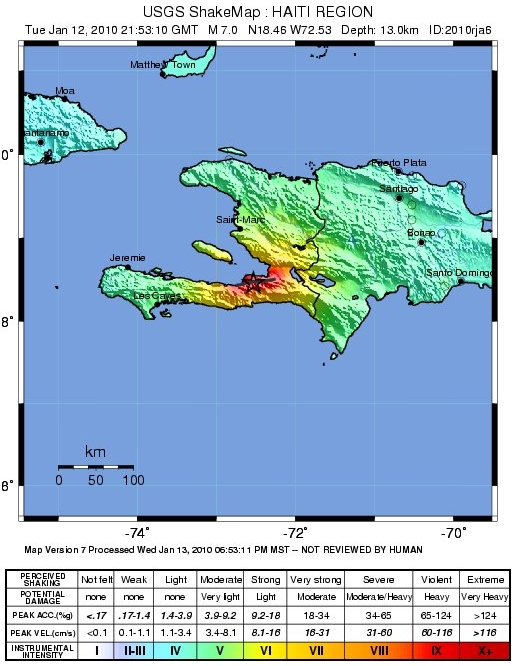
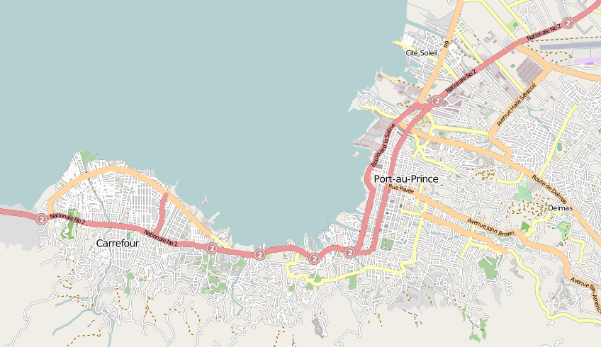
Port-au-Prince () is an arrondissement in the Ouest department of Haiti. It had 2,109,516 inhabitants at the 2003 Census which was estimated to have risen to 2,759,991 in 2015 in an area of 735.78 sq km (284.09 sq mi). Postal codes in the Port-au-Prince Arrondissement start with the number 61. Communes The arrondissement consists of the following communes: * Port-au-Prince * Carrefour * Cité Soleil * Delmas * Gressier * Kenscoff * Pétion-Ville * Tabarre History 2010 7.0 earthquake On 12 January 2010, a magnitude 7.0 earthquake struck in the arrondissement, the largest in Haiti in two centuries. The city of Port-au-Prince suffered much damage, and estimates of upwards of 50,000 deaths, with many facilities destroyed. In Pétion-Ville, the earthquake collapsed a hospital in the city. In Carrefour, half of the buildings were destroyed in the worst-affected areas.ABC News'Haiti Disaster Like "No Other"' AFP, Lisa Millar, ''17 January 2010'' (accessed 17 January 2010) ... [...More Info...] [...Related Items...] OR: [Wikipedia] [Google] [Baidu] |
Caribbean
The Caribbean ( , ; ; ; ) is a region in the middle of the Americas centered around the Caribbean Sea in the Atlantic Ocean, North Atlantic Ocean, mostly overlapping with the West Indies. Bordered by North America to the north, Central America to the west, and South America to the south, it comprises numerous List of Caribbean islands, islands, cays, islets, reefs, and banks. It includes the Lucayan Archipelago, Greater Antilles, and Lesser Antilles of the West Indies; the Quintana Roo Municipalities of Quintana Roo#Municipalities, islands and Districts of Belize#List, Belizean List of islands of Belize, islands of the Yucatán Peninsula; and the Bay Islands Department#Islands, Bay Islands, Miskito Cays, Archipelago of San Andrés, Providencia and Santa Catalina, Archipelago of San Andrés, Providencia, and Santa Catalina, Corn Islands, and San Blas Islands of Central America. It also includes the coastal areas on the Mainland, continental mainland of the Americas bordering the ... [...More Info...] [...Related Items...] OR: [Wikipedia] [Google] [Baidu] |
Architectural Association School Of Architecture
The Architectural Association School of Architecture in London, commonly referred to as the AA, is the oldest private school of architecture in the UK. The AA hosts exhibitions, lectures, academic conference, symposia and publications. History The Architectural Association was founded in 1847 as an alternative to the practice of training young men via apprenticeship to established architects. Apprenticeships offered no guarantee of educational quality or professional standards, and the system was believed to be "rife with Conflict of interest, vested interests and open to abuse, dishonesty and incompetence". Two articled pupils, Robert Kerr (architect), Robert Kerr (1823–1904) and Charles Gray (1827/28–1881), proposed a systematic course of training provided by the students themselves. Following a merger with the Association of Architectural Draughtsmen, the first formal meeting under the name of the Architectural Association took place in May 1847 at Lyon's Inn, Lyons I ... [...More Info...] [...Related Items...] OR: [Wikipedia] [Google] [Baidu] |
Tropical Savanna Climate
Tropical savanna climate or tropical wet and dry climate is a tropical climate sub-type that corresponds to the Köppen climate classification categories ''Aw'' (for a dry "winter") and ''As'' (for a dry "summer"). The driest month has less than of precipitation and also less than 100-\left (\frac \right)mm of precipitation. This latter fact is in a direct contrast to a tropical monsoon climate, whose driest month sees less than of precipitation but has ''more'' than 100-\left (\frac \right) of precipitation. In essence, a tropical savanna climate tends to either see less overall rainfall than a tropical monsoon climate or have more pronounced dry season(s). It is impossible for a tropical savanna climate to have more than as such would result in a negative value in that equation. In tropical savanna climates, the dry season can become severe, and often drought conditions prevail during the course of the year. Tropical savanna climates often feature tree-studded grasslands due ... [...More Info...] [...Related Items...] OR: [Wikipedia] [Google] [Baidu] |
Dominican Republic
The Dominican Republic is a country located on the island of Hispaniola in the Greater Antilles of the Caribbean Sea in the Atlantic Ocean, North Atlantic Ocean. It shares a Maritime boundary, maritime border with Puerto Rico to the east and a Dominican Republic–Haiti border, land border with Haiti to the west, occupying the Geography of the Dominican Republic, eastern five-eighths of Hispaniola which, along with Saint Martin (island), Saint Martin, is one of only two islands in the Caribbean shared by two sovereign states. In the Antilles, the country is the List of Caribbean islands by area, second-largest nation by area after Cuba at and List of Caribbean countries by population, second-largest by population after Haiti with approximately 11.4 million people in 2024, of whom 3.6 million reside in the Greater Santo Domingo, metropolitan area of Santo Domingo, the capital city. The native Taíno people had inhabited Hispaniola prior to European colonization of the America ... [...More Info...] [...Related Items...] OR: [Wikipedia] [Google] [Baidu] |
Constanza, Dominican Republic
Constanza is a town and municipality in La Vega Province, Dominican Republic. Located in the Cordillera Central, Dominican Republic, Cordillera Central region, Constanza is known for having the coldest average temperature for a settlement on the island of Hispaniola, as well as the entire Caribbean. History The name of Constanza has its origin in the legend the daughter of a local Native Taíno people, Taíno cacique, chief who lived in the valley. Constanza was a sparsely populated area, though several explorers knew the valley in colonial times, and there was a settler named Victoriano Velano who brought Europe, European agriculture and ranching culture to the area in 1750. In 1852, the Germans, German-United Kingdom, British explorer and consul Sir Robert Hermann Schomburgk mentioned the existence of a farm in the valley of Constanza on his way through the region. The town was formally founded in 1894. It was incorporated into a municipality in La Vega Province on September ... [...More Info...] [...Related Items...] OR: [Wikipedia] [Google] [Baidu] |
Hispaniola
Hispaniola (, also ) is an island between Geography of Cuba, Cuba and Geography of Puerto Rico, Puerto Rico in the Greater Antilles of the Caribbean. Hispaniola is the most populous island in the West Indies, and the second-largest by List of Caribbean islands by area, land area, after Geography of Cuba, Cuba. The island is Dominican Republic–Haiti border, divided into two separate Sovereign state, sovereign countries: the Spanish-speaking Geography of the Dominican Republic, Dominican Republic () to the east and the French language, French and Haitian Creole–speaking Geography of Haiti, Haiti () to the west. The only other divided island in the Caribbean is Saint Martin (island), Saint Martin, which is shared between France () and the Kingdom of the Netherlands, Netherlands (). At the time of the European arrival of Christopher Columbus, Hispaniola was home to the Ciguayo language, Ciguayo, Macorix language, Macorix, and Taíno Indigenous peoples of the Caribbean, native pe ... [...More Info...] [...Related Items...] OR: [Wikipedia] [Google] [Baidu] |
Chaîne De La Selle
Chaîne may refer to: People * Marius Chaîne (1873–1960), French scholar of Ethiopic and Coptic philology Places *Chaîne des Puys, a north-south oriented chain of cinder cones, lava domes, and maars in the Massif Central of France * Chaîne de l'Épine, the department of Savoie in southeast France * Chaîne du Thaljah, a range of mountains in the Gafsa Governorate of Tunisia Entertainment * Chaîne (novel) – a 1974 novel by Saidou Bokoum about Africans living in France. * Radio Algeria radio stations: ** Chaîne 1 in Arabic. ** Chaîne 2 in Berber. ** Chaîne 3 in French. * La Chaîne Météo, a French TV channel, broadcasting weather forecasts 24 hours a day *La Chaîne Disney, a Canadian French-language specialty channel Other *Chaîne opératoire Chaîne opératoire (; ) is a term used throughout anthropological discourse, most commonly in archaeology and sociocultural anthropology. The term denotes a description of the stages of production of material culture—esp ... [...More Info...] [...Related Items...] OR: [Wikipedia] [Google] [Baidu] |
Port-au-Prince
Port-au-Prince ( ; ; , ) is the Capital city, capital and List of cities in Haiti, most populous city of Haiti. The city's population was estimated at 1,200,000 in 2022 with the metropolitan area estimated at a population of 2,618,894. The metropolitan area is defined by the IHSI as including the Communes of Haiti, communes of Port-au-Prince, Delmas, Ouest, Delmas, Cité Soleil, Tabarre, Carrefour, Ouest, Carrefour, and Pétion-Ville. The city of Port-au-Prince is on the Gulf of Gonâve: the bay on which the city lies, which acts as a natural harbor, has sustained economic activity since the civilizations of the Taíno. It was first incorporated under Saint-Domingue, French colonial rule in 1749. The city's layout is similar to that of an amphitheater; commercial districts are near the water, while residential neighborhoods are located on the hills above. Its population is difficult to ascertain due to the rapid growth of slums in the hillsides above the city; however, recent ... [...More Info...] [...Related Items...] OR: [Wikipedia] [Google] [Baidu] |


