|
Kathiawar
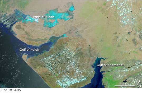
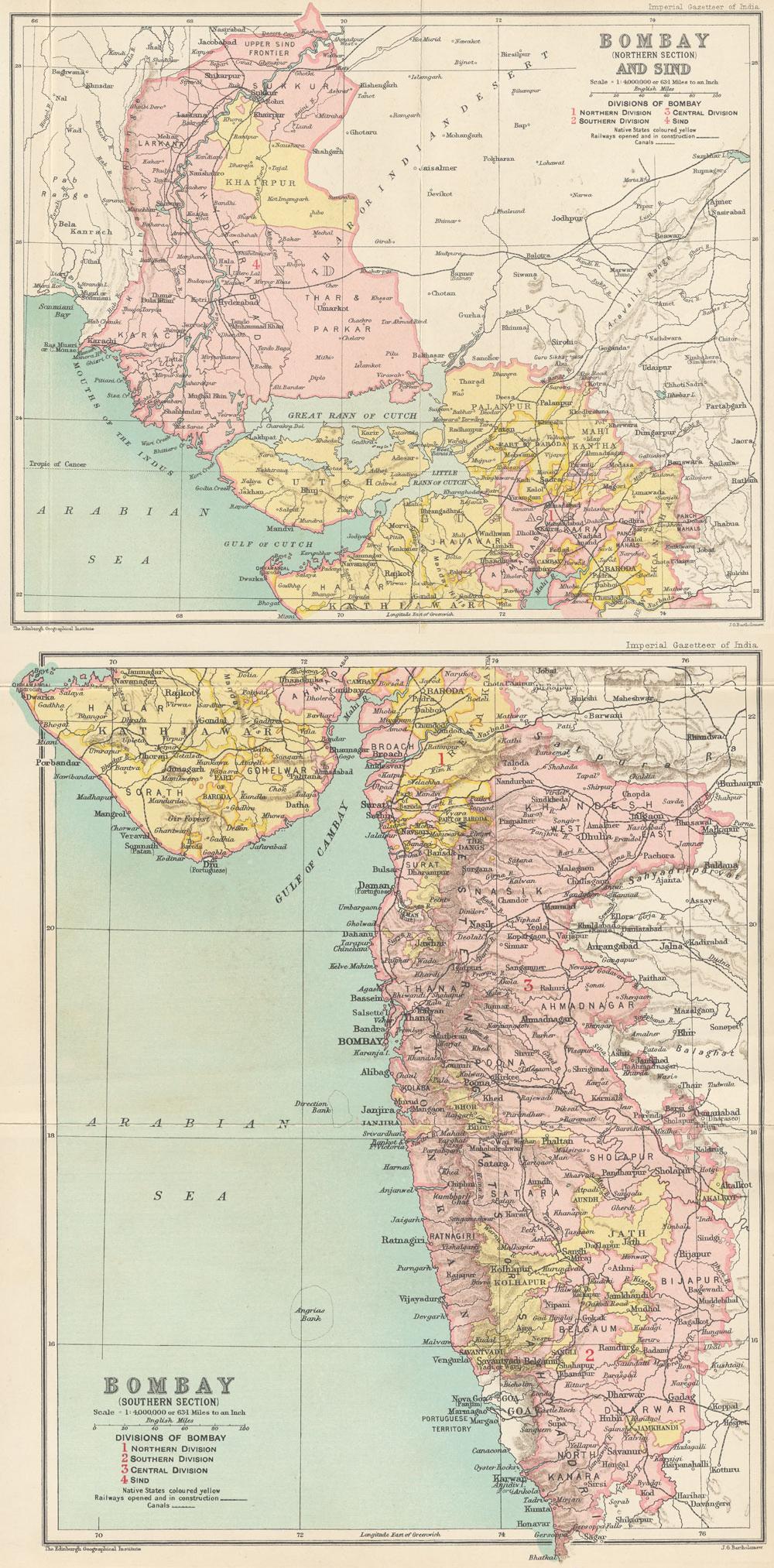
Kathiawar (), also known as Saurashtra, is a peninsula in the south-western Gujarat state in India, bordering the Arabian Sea and covering about . It is bounded by the Kutch district in the north, the Gulf of Kutch in the northwest, and by the Gulf of Khambhat in the east. In the northeast, it is connected to the rest of the state and borders on the low, fertile hinterland of Ahmedabad. It is crossed by two belts of hill country and is drained radially by nine rivers which have little natural flow aside from in monsoon months, thus dams have been built on some of these. Kathiawar ports have been flourishing centres of trade and commerce since at least the 16th century. It was formerly a Saurashtra (state), state of India. Etymology and history The name Kathiawad seems to have been derived from the early settlements of Kathikas or Kathi people, Kathis who entered Gujarat from Sindh in early centuries of the Common Era. The name "Saurashtra" itself is from Sanskrit (, ), the ... [...More Info...] [...Related Items...] OR: [Wikipedia] [Google] [Baidu] |
Saurashtra (state)
Saurashtra State, formally known as United State of Kathiawar and later United State of Saurashtra, was a States and union territories of India, state of India that existed between 1948 and 1956, on Saurashtra (region), Saurashtra alias Kathiawar peninsula, with Rajkot as its capital. History Formation as United State of Kathiawar Saurashtra state was originally named the United State of Kathiawar. It was formed on 15 February 1948, from approximately 200 large and small Princely States of the colonial Baroda, Western India and Gujarat States Agency of the British raj territory under direct colonial rule. The name of State was given after the Kathiawar and Saurashtra (region), Saurashtra region, both of which generally denote the same geographical region of lands on the main peninsula of Gujarat. The persuasions of Sardar Vallabhbhai Patel and the influence of Mahatma Gandhi are credited for persuading most of the States of Kathiawar to join the Dominion of India, Union o ... [...More Info...] [...Related Items...] OR: [Wikipedia] [Google] [Baidu] |
Gujarat
Gujarat () is a States of India, state along the Western India, western coast of India. Its coastline of about is the longest in the country, most of which lies on the Kathiawar peninsula. Gujarat is the List of states and union territories of India by area, fifth-largest Indian state by area, covering some ; and the List of states and union territories of India by population, ninth-most populous state, with a population of 60.4 million in 2011. It is bordered by Rajasthan to the northeast, Dadra and Nagar Haveli and Daman and Diu to the south, Maharashtra to the southeast, Madhya Pradesh to the east, and the Arabian Sea and the Pakistani province of Sindh to the west. Gujarat's capital city is Gandhinagar, while its largest city is Ahmedabad. The Gujarati people, Gujaratis are indigenous to the state and their language, Gujarati language, Gujarati, is the state's official language. The state List of Indus Valley civilisation sites#List of Indus Valley sites discovered, ... [...More Info...] [...Related Items...] OR: [Wikipedia] [Google] [Baidu] |
Gujarati Language
Gujarati ( ; , ) is an Indo-Aryan language native to the Indian state of Gujarat and spoken predominantly by the Gujarati people. Gujarati is descended from Old Western Rājasthāni, Old Gujarati (). In India, it is one of the 22 Languages with official status in India, scheduled languages of the Union. It is also the official language in the state of Gujarat, as well as an official language in the union territory of Dadra and Nagar Haveli and Daman and Diu. As of 2011, Gujarati is the List of languages by number of native speakers in India, 6th most widely spoken language in India by number of native speakers, spoken by 55.5 million speakers which amounts to about 4.5% of the total Indian population. It is the List of languages by number of native speakers, 26th most widely spoken language in the world by number of native speakers as of 2007.Mikael Parkvall, "Världens 100 största språk 2007" (The World's 100 Largest Languages in 2007), in ''Nationalencyklopedin''. Asteri ... [...More Info...] [...Related Items...] OR: [Wikipedia] [Google] [Baidu] |
Kathi People
The Kāṭhī people are a small group of clans found in the peninsular Kathiawar (historically called Saurashtra) of Gujarat, western India. The Maratha Empire, and later the British Raj, renamed the Saurashtra as Kathiawar as the Kāṭhīs were prominent there during the 17th-18th centuries. History The sun-worshipping Kāṭhīs, who lent their name to the region of Kathiawar, are documented as serving under the Cūdāsamās during the eleventh century. Previously under the authority of the Sūmrās of Sind, they were compelled to escape Sindh and seek sanctuary with the Vālā chieftain in Saurashtra. During this era, the Kāṭhīs appeared to be marginalised, as the Vālā leader was reportedly ostracised from his caste after dining with them, leading to his deposition from kingship by his siblings. He subsequently allied himself with the Kāṭhī people to conquer various territories, including seizing the Than-Chotila area from the Soḍhās. Offspring of the Kā ... [...More Info...] [...Related Items...] OR: [Wikipedia] [Google] [Baidu] |
Gulf Of Khambhat
The Gulf of Khambhat, also known as the Gulf of Cambay, is a bay on the Arabian Sea coast of India, bordering the state of Gujarat just north of Mumbai and Diu Island. The Gulf of Khambhat is about long, about wide in the north and up to wide in the south. Major rivers draining Gujarat are the Narmada, Tapti, Mahi and the Sabarmati, that form estuaries in the gulf. It divides the Kathiawar Peninsula from the south-eastern part of Gujarat.Trivedi, P. and Soni, V. C. (2012)Significant bird records and local extinctions in Purna and Ratanmahal Wildlife Sanctuaries, Gujarat, India Jhala, Y. V., Qureshi, Q., Sinha, P. R. (Eds.) (2011)''Status of tigers, co-predators and prey in India, 2010.''National Tiger Conservation Authority, Government of India, New Delhi, and Wildlife Institute of India, Dehradun. TR 2011/003. There are plans to construct a dam, Kalpasar Project, across the gulf. Wildlife To the west of the Gulf, Asiatic lions inhabit the Gir Forest National Park ... [...More Info...] [...Related Items...] OR: [Wikipedia] [Google] [Baidu] |
Sindh
Sindh ( ; ; , ; abbr. SD, historically romanized as Sind (caliphal province), Sind or Scinde) is a Administrative units of Pakistan, province of Pakistan. Located in the Geography of Pakistan, southeastern region of the country, Sindh is the third-largest province of Pakistan by land area and the Demographics of Pakistan, second-largest province by population after Punjab, Pakistan, Punjab. It is bordered by the Pakistani provinces of Balochistan, Pakistan, Balochistan to the west and north-west and Punjab, Pakistan, Punjab to the north. It shares an India-Pakistan border, International border with the Indian states of Gujarat and Rajasthan to the east; it is also bounded by the Arabian Sea to the south. Sindh's landscape consists mostly of alluvial plains flanking the Indus River, the Thar Desert of Sindh, Thar Desert in the eastern portion of the province along the India–Pakistan border, international border with India, and the Kirthar Mountains in the western portion of ... [...More Info...] [...Related Items...] OR: [Wikipedia] [Google] [Baidu] |
Kutch District
Kutch district (), officially spelled Kachchh is a district of Gujarat state in western India, with its headquarters (capital) at Bhuj. Covering an area of 45,674 km2, it is the largest district of India. The area of Kutch is larger than the entire area of other Indian states like Haryana (44,212 km2) and Kerala (38,863 km2), as well as the country of Estonia (45,335 km2). The population of Kutch is about 2,092,371. It has 10 talukas, 939 villages and 6 Municipal governance in India, municipalities. The Kutch district is home to the Kutchi people who speak the Kutchi language. Kutch literally means something which intermittently becomes wet and dry; a large part of this district is known as Rann of Kutch which is shallow wetland which submerges in water during the rainy season and becomes dry during other seasons. The same word is also used in Sanskrit origin for a tortoise. The Rann is known for its marshy Salt pan (geology), salt flats which become snow wh ... [...More Info...] [...Related Items...] OR: [Wikipedia] [Google] [Baidu] |
Abiria
Abiria also known as Abhiria, Aberia, or Abhiradesha was the country of the Abhira Kshatriyas in ancient India. It is mentioned in the ''Periplus of the Erythraean Sea'' and by Ptolemy in his '' Geographia''. The ''Periplus'' mentions it as ''Aberia'' with the coastal district Syrastrene (modern-day Saurashtra, Gujarat), and Ptolemy locates it above the Indus delta. Location The ''Periplus of the Erythraean Sea'' and '' Geographia'' by Ptolemy locate Abiria between the lower Sindh valley and Kathiawar, apparently in southwest Rajputana and adjoining regions. In the ''Puranas'' however, the domains of the Abhira kings were located in the northwestern region of the Deccan. Mention by Ptolemy ''Abiria'' was mentioned by Ptolemy when he described the territory of the Kshatrapa, Chastana: Mention in the ''Periplus of the Erythraean Sea'' Abiria is also mentioned in the 1st century CE ''Periplus of the Erythraean Sea'': "Beyond the gulf of Baraca is that of Barygaza and th ... [...More Info...] [...Related Items...] OR: [Wikipedia] [Google] [Baidu] |
Peninsula
A peninsula is a landform that extends from a mainland and is only connected to land on one side. Peninsulas exist on each continent. The largest peninsula in the world is the Arabian Peninsula. Etymology The word ''peninsula'' derives , . The word entered English in the 16th century. Definitions A peninsula is generally defined as a piece of land surrounded on most sides by water. A peninsula may be bordered by more than one body of water, and the body of water does not have to be an ocean or a sea. A piece of land on a very tight river bend or one between two rivers is sometimes said to form a peninsula, for example in the New Barbadoes Neck in New Jersey, United States. A peninsula may be connected to the mainland via an isthmus, for example, in the Isthmus of Corinth which connects to the Peloponnese peninsula. Formation and types Peninsulas can be formed from continental drift, glacial erosion, meltwater, glacial meltwater, glacial deposition (geology), deposition, ... [...More Info...] [...Related Items...] OR: [Wikipedia] [Google] [Baidu] |
Bharuch
Bharuch () is a city at the mouth of the river Narmada in Gujarat in western India. Bharuch is the administrative headquarters of Bharuch District. The city of Bharuch and surroundings have been settled since times of antiquity. It was a ship building centre and sea port in the pre-compass coastal trading routes for trading with the Occident and the East, perhaps as far back as the days of earliest trade connections. The route made use of the regular and predictable monsoon winds or galleys. Many goods from the Far East and Far West (the famed Spices and Silk trade) were shipped there during the annual monsoon winds, making it a terminus for several key land-sea trade routes. Bharuch was known to the Greeks, the Parthian Empire, in the Roman Empire, the Chinese, and in other Western and Eastern centres of civilisation through the end of the European Middle Ages and other the middle ages of the world.Periplus of the Erythraean Sea [...More Info...] [...Related Items...] OR: [Wikipedia] [Google] [Baidu] |
Nahapana
Nahapana (Ancient Greek: ; Kharosthi: , ; Brahmi script, Brahmi: , ;), was a member of Western Satraps, Kshaharata dynasty in northwestern India, who ruled during the 1st or 2nd century CE. According to one of his coins, he was the son of Bhumaka. Name Nahapana's name appears on his coins in the Kharosthi form (), the Brahmi form (), and the Greek alphabet, Greek form (), which are derived from the Saka language, Saka name , which means "protector of the clan". Period The exact period of Nahapana is uncertain. A group of his inscriptions are dated to the years 41-46 of an unspecified era. Assuming that this era is the Shaka era (which starts in 78 CE), some scholars have assigned his reign to 119-124 CE. Some scholars argue that his reign lasted from 41 to 46 and assign his rule to a different period. For example, Krishna Chandra Sagar assigns his reign to 24-70 CE, while R.C.C. Fynes dates it to -71 CE, and Shailendra Bhandare regards 78 CE as the last year of his ... [...More Info...] [...Related Items...] OR: [Wikipedia] [Google] [Baidu] |
Scythia
Scythia (, ) or Scythica (, ) was a geographic region defined in the ancient Graeco-Roman world that encompassed the Pontic steppe. It was inhabited by Scythians, an ancient Eastern Iranian equestrian nomadic people. Etymology The names and are themselves Latinisations of the Ancient Greek names () and (), which were themselves derived from the ancient Greek names for the Scythians, () and (), derived from the Scythian endonym . Geography Scythia proper The territory of the Scythian kingdom of the Pontic steppe extended from the Don river in the east to the Danube river in the west, and covered the territory of the treeless steppe immediately north of the Black Sea's coastline, which was inhabited by nomadic pastoralists, as well as the fertile black-earth forest-steppe area to the north of the treeless steppe, which was inhabited by an agricultural population. The northern border of this Scythian kingdom were the deciduous woodlands, while several rivers, incl ... [...More Info...] [...Related Items...] OR: [Wikipedia] [Google] [Baidu] |


