|
Kankai River
The Kankai River (, also referred to as Kankai Mai) is a trans-boundary river flowing through the hills of Ilam and the plains of the Jhapa District in Nepal. It begins at the confluence of the Mai Khola and Deb Mai Khola rivers. The river overflows during monsoons, at times across thousands of hectares of fertile plains of Jhapa. The Kankai Irrigation Project, launched by the Nepalese government, irrigates southern Jhapa, including Shivganj, Pachgachi, and Mahavara. The Kankai has several tourist hotspots along its course, such as in the areas of Domukha, Dhanuskoti, Chuli, Chepti, and Maipokhari. The Kotihom Surunga Municipality holds an annual Mai Mela fair on Magh 1 (January 14), where people from Jhapa, Morang, Ilam, and various parts of India come to enjoy and perform religious activities. A holy river for many Hindus living nearby, the Kotihom (eastern) riverbank is a common site for death rituals. The cremation service Kankai Aryaghat was funded by public investm ... [...More Info...] [...Related Items...] OR: [Wikipedia] [Google] [Baidu] |
Nepal
Nepal, officially the Federal Democratic Republic of Nepal, is a landlocked country in South Asia. It is mainly situated in the Himalayas, but also includes parts of the Indo-Gangetic Plain. It borders the Tibet Autonomous Region of China China–Nepal border, to the north, and India India–Nepal border, to the south, east, and west, while it is narrowly separated from Bangladesh by the Siliguri Corridor, and from Bhutan by the States and union territories of India, Indian state of Sikkim. Nepal has a Geography of Nepal, diverse geography, including Terai, fertile plains, subalpine forested hills, and eight of the world's ten List of highest mountains#List, tallest mountains, including Mount Everest, the highest point on Earth. Kathmandu is the nation's capital and List of cities in Nepal, its largest city. Nepal is a multi-ethnic, multi-lingual, multi-religious, and multi-cultural state, with Nepali language, Nepali as the official language. The name "Nepal" is first record ... [...More Info...] [...Related Items...] OR: [Wikipedia] [Google] [Baidu] |
Bihar
Bihar ( ) is a states and union territories of India, state in Eastern India. It is the list of states and union territories of India by population, second largest state by population, the List of states and union territories of India by area, 12th largest by area, and the List of Indian states and union territories by GDP, 14th largest by GDP in 2024. Bihar borders Uttar Pradesh to its west, Nepal to the north, the northern part of West Bengal to the east, and Jharkhand to the south. Bihar is split by the river Ganges, which flows from west to east. On 15 November 2000, a large chunk of southern Bihar was ceded to form the new state of Jharkhand. Around 11.27% of Bihar's population live in urban areas as per a 2020 report. Additionally, almost 58% of Bihari people, Biharis are below the age of 25, giving Bihar the highest proportion of young people of any Indian state. The official language is Hindi, which shares official status alongside that of Urdu. The main native languag ... [...More Info...] [...Related Items...] OR: [Wikipedia] [Google] [Baidu] |
Panchganchi
Panchganchi was a village development committee in Jhapa District in the Province No. 1 of south-eastern Nepal. At the time of the 2011 Nepal census it had a population of 16600 people living in 2207 individual households. It was later merged with Satasidham, Dharampur, and Shivaganj to form the Shivasatakshi municipality Shivasatakshi is a municipality in the southeastern part of Jhapa District in the Koshi Province of eastern Nepal. The new municipality was formed by merging four existing Village development committee (Nepal), VDCs—Shivaganj, Satasidham, Dharam .... References Populated places in Jhapa District {{Jhapa-geo-stub ... [...More Info...] [...Related Items...] OR: [Wikipedia] [Google] [Baidu] |
Satasidham
Satasidham is a village development committee in Jhapa District in the Province No. 1 of south-eastern Nepal. At the time of the 1991 Nepal census it had a population of 20,809 people living in 3842 individual households. It was later merged with Shivaganj, Dharampur, and Panchgachhi to form the Shivasatakshi municipality Shivasatakshi is a municipality in the southeastern part of Jhapa District in the Koshi Province of eastern Nepal. The new municipality was formed by merging four existing Village development committee (Nepal), VDCs—Shivaganj, Satasidham, Dharam .... References Populated places in Jhapa District {{Jhapa-geo-stub ... [...More Info...] [...Related Items...] OR: [Wikipedia] [Google] [Baidu] |
Alluvium
Alluvium (, ) is loose clay, silt, sand, or gravel that has been deposited by running water in a stream bed, on a floodplain, in an alluvial fan or beach, or in similar settings. Alluvium is also sometimes called alluvial deposit. Alluvium is typically geologically young and is not Consolidation (geology), consolidated into solid rock. Sediments deposited underwater, in seas, estuaries, lakes, or ponds, are not described as alluvium. Floodplain alluvium can be highly fertile, and supported some of the earliest human civilizations. Definitions The present Scientific consensus, consensus is that "alluvium" refers to loose sediments of all types deposited by running water in floodplains or in alluvial fans or related landforms. However, the meaning of the term has varied considerably since it was first defined in the French dictionary of Antoine Furetière, posthumously published in 1690. Drawing upon concepts from Roman law, Furetière defined ''alluvion'' (the French term for al ... [...More Info...] [...Related Items...] OR: [Wikipedia] [Google] [Baidu] |
Siphon
A siphon (; also spelled syphon) is any of a wide variety of devices that involve the flow of liquids through tubes. In a narrower sense, the word refers particularly to a tube in an inverted "U" shape, which causes a liquid to flow upward, above the surface of a reservoir, with no pump, but powered by the fall of the liquid as it flows down the tube under the pull of gravity, then discharging at a level lower than the surface of the reservoir from which it came. There are two leading theories about how siphons cause liquid to flow uphill, against gravity, without being pumped, and powered only by gravity. The traditional theory for centuries was that gravity pulling the liquid down on the exit side of the siphon resulted in reduced pressure at the top of the siphon. Then atmospheric pressure was able to push the liquid from the upper reservoir, up into the reduced pressure at the top of the siphon, like in a barometer or drinking straw, and then over. However, it has been demo ... [...More Info...] [...Related Items...] OR: [Wikipedia] [Google] [Baidu] |
Debouch
In hydrology, a debouch (or debouche) is a place where runoff from a small, confined space discharges into a larger, broader body of water. The word is derived from the French verb ''déboucher'' (), which means "to unblock, to clear". The term also has a military usage. Geology In fluvial geomorphology, a debouch is a place where runoff from a small, confined space emerges into a larger, broader space. Common examples are when a stream runs into a river or when a river runs into an ocean. Debouching can generate massive amounts of sediment transport. When a narrow stream travels down a mountain pass into a basin, an alluvial fan will form from the mass deposit of the sediment. The four largest rivers (the Amazon, the Ganges, the Yangtze and the Yellow) are responsible for 20% of the global discharge of sediment in to the oceans by debouches. Geography In fluvial geography, a debouch is a place where a body of water pours forth from a narrow opening. Some examples are: where a ... [...More Info...] [...Related Items...] OR: [Wikipedia] [Google] [Baidu] |
Weir
A weir or low-head dam is a barrier across the width of a river that alters the flow characteristics of water and usually results in a change in the height of the water level. Weirs are also used to control the flow of water for outlets of lakes, ponds, and reservoirs. There are many weir designs, but commonly water flows freely over the top of the weir crest before cascading down to a lower level. There is no single definition as to what constitutes a weir. ''Weir'' can also refer to the skimmer found in most in-ground swimming pools, which controls the flow of water pulled into the filtering system. Etymology The word likely originated from Middle English ''were'', Old English ''wer'', a derivative of the root of the verb ''werian,'' meaning "to defend, dam". The German cognate is ''Wehr'', which means the same as English weir. Function Commonly, weirs are used to prevent flooding, measure water discharge, and help render rivers more Navigability, navigable by boat. In ... [...More Info...] [...Related Items...] OR: [Wikipedia] [Google] [Baidu] |
Ogee
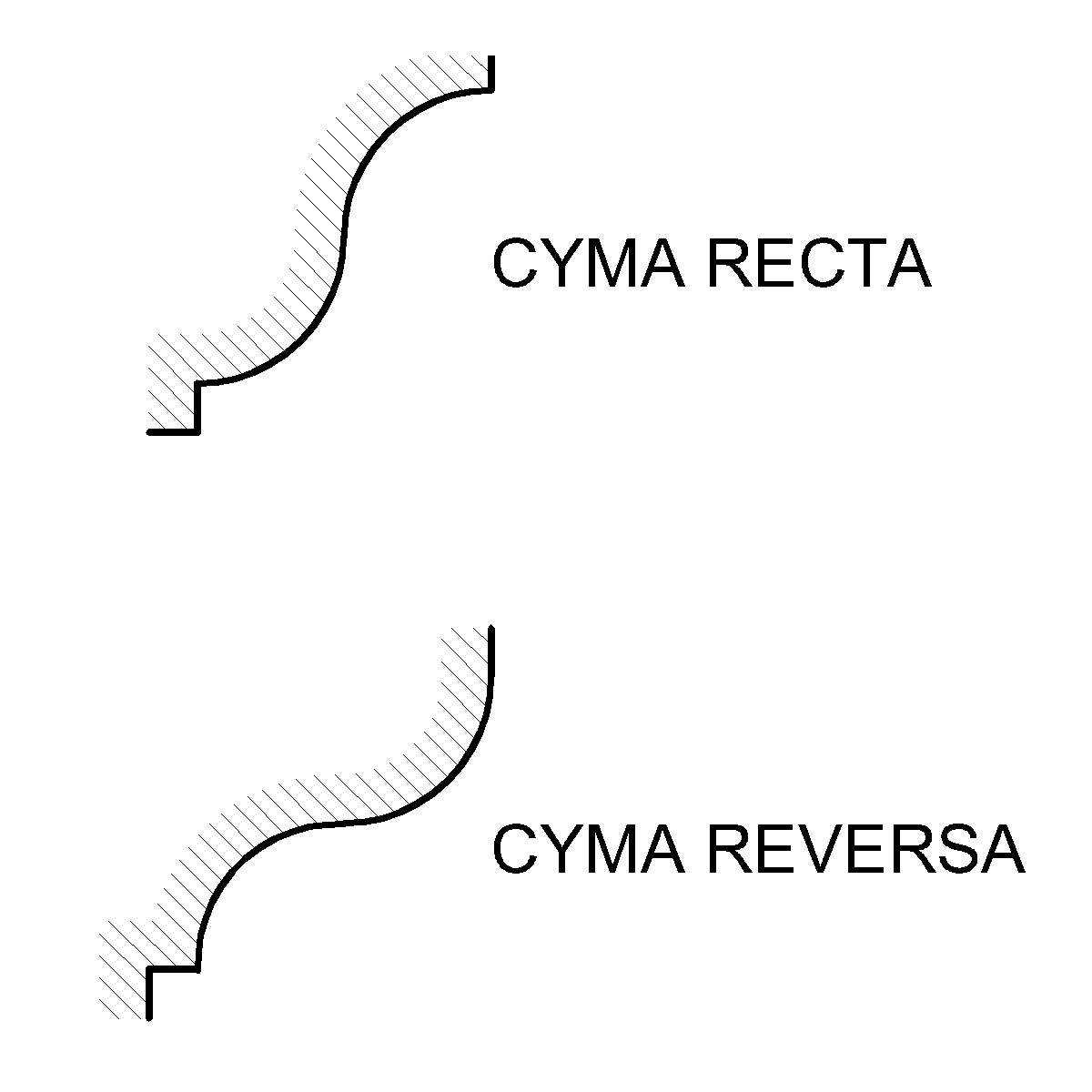
An ogee ( ) is an object, element, or curve—often seen in architecture and building trades—that has a serpentine- or extended S-shape (Sigmoid curve, sigmoid). Ogees consist of a "double curve", the combination of two semicircle, semicircular curves or arc (geometry), arcs that, as a result of a inflection point, point of inflection from concave function, concave to convex function, convex or ''vice versa'', have ends of the overall curve that point in opposite directions (and have tangents that are approximately parallel). First seen in textiles in the 12th century, the use of ogee elements—in particular, in the design of arches—has been said to characterise various Gothic architecture, Gothic and Gothic Revival architecture, Gothic Revival architectural styles. The shape has many such uses in architecture from those periods to the present day, including in the ogee arch in these architectural styles, where two ogees oriented as mirror images compose the sides of the ar ... [...More Info...] [...Related Items...] OR: [Wikipedia] [Google] [Baidu] |
Nepalese Rupee
The Nepalese rupee (; currency sign, sign: रु; ISO 4217, code: NPR) is the official currency and legal tender of Nepal. It is also sometimes abbreviated as N₨ or Re./Rs. informally. The rupee is subdivided into 100 paisa, although coins of lower denominations are rarely used today. It is issued and regulated by the Nepal Rastra Bank, the central bank of Nepal. The Nepalese rupee was introduced in 1932, replacing the silver-based mohar at a rate of 2 mohar = 1 rupee. Since 1994, it has been officially fixed exchange rate, pegged to the Indian rupee at a rate of रु1.60 = ₹1, having previously been pegged at रु1.45 = ₹1. , the Nepalese rupee is accepted for domestic transactions only within Nepal and is not legally circulated outside its borders. Foreign exchange is regulated by the central bank and subject to strict limits. History The rupee was introduced in 1932, replacing the silver Nepalese mohar, mohar at a rate of 2 mohar = 1 rupee. At first, the rupee was ... [...More Info...] [...Related Items...] OR: [Wikipedia] [Google] [Baidu] |
Asian Development Bank
The Asian Development Bank (ADB) is a regional development bank to promote social and economic development in Asia. The bank is headquartered in Metro Manila, Philippines and maintains 31 field offices around the world. The bank was established on 19 December 1966 and admits the members of the UN Economic and Social Commission for Asia and the Pacific (UNESCAP, formerly the Economic Commission for Asia and the Far East or ECAFE), and non-regional developed countries. Starting with 31 members at its establishment, by 2019 ADB had 69 members. The ADB was modeled closely on the World Bank and has a similar weighted voting system, where votes are distributed in proportion with members' capital subscriptions. ADB releases an annual report that summarizes its operations, budget, and other materials for review by the public. The ADB-Japan Scholarship Program (ADB-JSP) enrolls about 300 students annually in academic institutions located in 10 countries within the Region. After comple ... [...More Info...] [...Related Items...] OR: [Wikipedia] [Google] [Baidu] |
Mahendra Highway
Mahendra Highway or NH01 (previously: H01) (), also called East-West Highway (), runs across the Terai geographical region of Nepal, from Mechinagar in the east to Bhim Datta in the west, cutting across the entire width of the country. It is the longest highway in Nepal and was constructed in cooperation with various countries. The highway is named after King Mahendra Shah. Overview The highway is mostly a single-lane road in each direction. It is a major infrastructure element because east–west travel was previously limited to the Hulaki Highway built during the Rana regime, expensive and limited air travel, or Nepalese trains and buses. The highway crosses the Terai from east to west for over . It connects Nepal from Kakarbhitta ( Mechinagar Municipality) to West Mahendra Nagar in the east. Bharatpur city and Chitwan Valley are located towards the central part of this highway. The major destinations along and around the highway are Mechinagar, Bhadrapur, Itahari, J ... [...More Info...] [...Related Items...] OR: [Wikipedia] [Google] [Baidu] |


