|
Kanisfluh
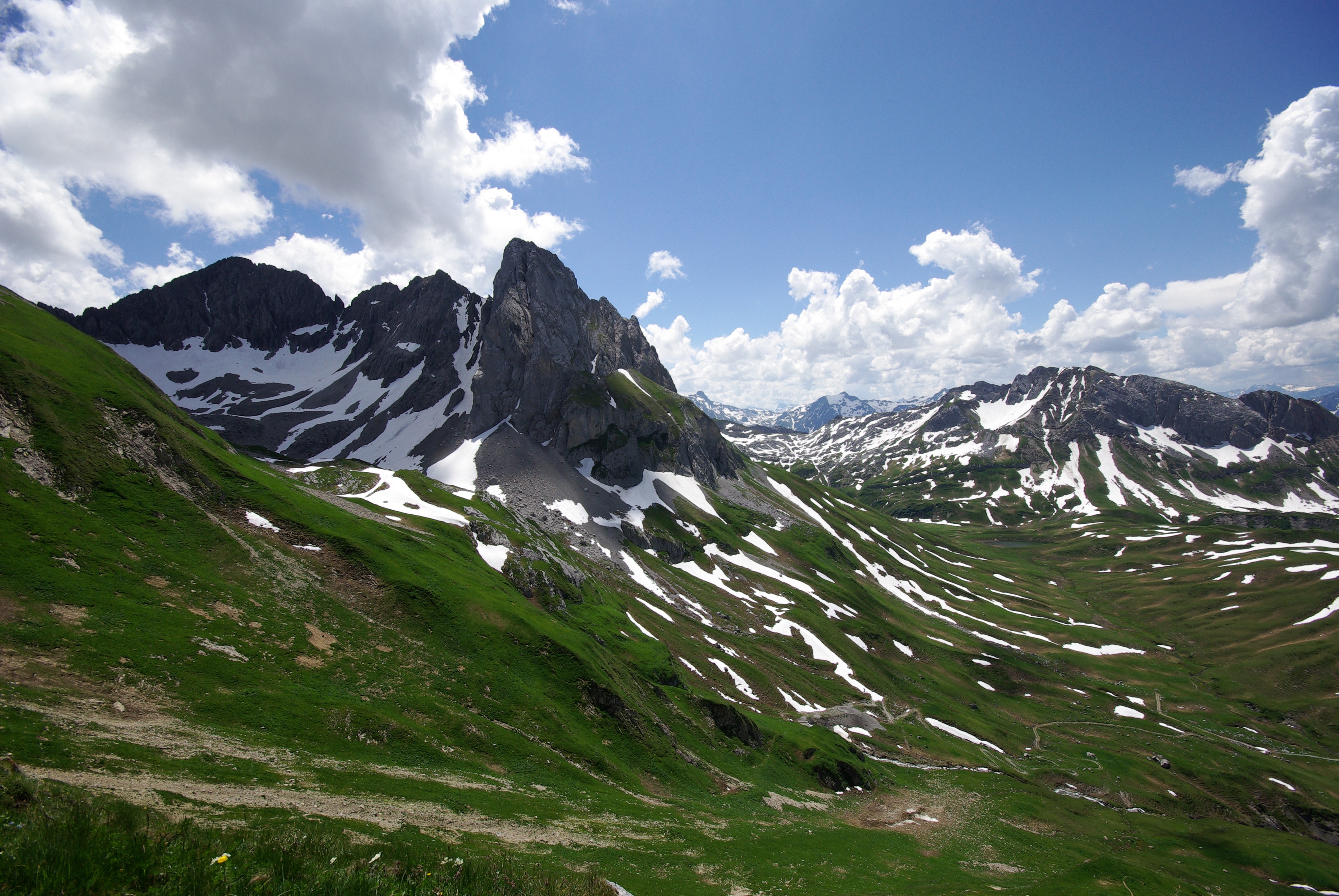
The Kanisfluh is a mostly isolated massif in the central Bregenz Forest Mountains between the municipalities Mellau and Au.The Kanisfluh is considered the most famous mountain and landmark of the Bregenz Forest, Vorarlberg, Austria. Location and peaks Viewed from the North, the prominent cliff face of the Kanisfluh dominates the valley of Schnepfau and Bregenzer Ach, while the grassy south slopes decline more gently. The highest peak is the "Holenke" at an elevation of 2,044 metres AA (6,706 feet), which can be climbed via a comfortable mountain trail ( SAC hiking scale T2). Other peaks are the "Hoher Stoß" (1,806 m AA), the "Runder Kopf" (2,014 m AA) and the "Sonnenspitze" (1,965 m AA). No trails lead to these, reaching them occasionally requires advanced mountaineering abilities. Image:Kanisfluh Nordseite.jpg, North side of the Kanisfluh Image:Edelweiss auf der Kanisfluh Hanno Thurnher Cinedoku Vorarlberg.JPG, Edelweiss on the Kanisfluh, Holenke in the background Im ... [...More Info...] [...Related Items...] OR: [Wikipedia] [Google] [Baidu] |
Bregenz Forest
The Bregenz Forest (german: Bregenzerwald, ) is one of the main regions in the state of Vorarlberg (Austria). It overlaps, but is not coterminous with, the Bregenz Forest Mountains, which belong to a range of the Northern Limestone Alps, specifically the northern flysch zone. It is the drainage basin of the Bregenzer Ach river. Geography The regional inhabitants often divide the Bregenz Forest into two main areas, the Vorderwald ('anterior forest') and Hinterwald ('hinterforest'). The Vorderwald, with its hills and low mountains, is closest to the Rhine valley. The Hinterwald has the higher mountains, with altitudes of up to 2,000 metres. The two regions have distinctive dialect variations. Villages The principal villages in the Bregenz Forest are Bezau (the local capital), Alberschwende, and Egg. Alberschwende, as a historic "''Hofsteig''" municipality was formerly not part of the Bregenz Forest region. Lower Bregenz Forest (''Vorderer Bregenzerwald'') (red) # Albersch ... [...More Info...] [...Related Items...] OR: [Wikipedia] [Google] [Baidu] |
Bregenz Forest Mountains
The Bregenz Forest Mountains, also the Bregenzerwald Mountains (german: Bregenzerwaldgebirge), are a range of the Northern Limestone Alps and Eastern Alps, named after the town of Bregenz. The Bregenz Forest Mountains are located entirely in the Austrian state of Vorarlberg. Definition The term Bregenz Forest Mountains refers to the range according to the Alpine Club classification of the Eastern Alps (AVE); the term Bregenz Forest, by contrast, refers to a landscape or region which is part of the Bregenzer Ache basin area. As a result, the Bregenz Forest Mountains and the Bregenz Forest are not conterminous. The Bregenz Forest region also includes the southwestern parts of the Allgäu Alps. On the other hand, the Bregenz Forest Mountains reach, to an extent, into the landscapes of the eastern Rhine Valley, as well as to the Walgau Valley of the Ill River and the Großes Walsertal in the south. As the range is not geologically uniform, the name is rarely used outside of Alpin ... [...More Info...] [...Related Items...] OR: [Wikipedia] [Google] [Baidu] |
Mellau
Mellau is a town in the Bregenz Forest in the westernmost Austrian state of Vorarlberg, part of the district of Bregenz. Geography Mellau covers an area of 40.55 km2. Mellau lies at the foot of the Kanisfluh mountain which is considered to be the Bregenz Forest's landmark. History From 1805 to 1814 Mellau belonged to Bavaria but then reverted to Austria. In 1870 there was a great fire in Mellau: The church, the school, the rectory and 18 other houses were razed. After the Second World War, from 1945 to 1955 the town was in the French zone of occupation. Population The municipality has about 1300 inhabitants. Coat of arms The coat of arms was designed by the artist Hubert Dietrich in 1962. It shows an uprooted fir tree, which symbolises the affiliation to the Bregenz Forest, and three crosses, which are a remembrance of the plague. Tourism Thanks to the merging of the two ski areas Damüls and Mellau in 2010, the largest ski area in the Bregenz Forest and one of th ... [...More Info...] [...Related Items...] OR: [Wikipedia] [Google] [Baidu] |
Au, Vorarlberg
Au is a town in the Bregenz Forest in Vorarlberg (Austria). Geography The town belongs to the Bregenz Forest, is part of the district of Bregenz, and lies in the '' Upper Bregenz Forst.'' 40 percent of its 45 km² area is covered with forest, 34.4% of the area is used as alpine pasture (''Almwirtschaft'') and for other forms of alpine agriculture. The town itself is unlike most others in the area, as it has no real center. Au is an example of a "scattered village" (German: ''Streudorf''). It consists of several districts: Am Stein, Argenau, Argenstein, Argenzipfel, Jaghausen, Kreuzgasse, Lebernau, Lugen, Lisse, Rehmen, Schrecken, and Wieden. The town hall is located in Argenau, but the parish church is located in Jaghausen. The district of Rehmen also has its own church. The river Bregenzer Ach, the largest river in the region, flows through Au and divides it into two parts: The one part is called ''Schattseite'' (meaning “shady side”), and consists of the d ... [...More Info...] [...Related Items...] OR: [Wikipedia] [Google] [Baidu] |
Metres Above The Adriatic
Metres above the Adriatic ( it, Metri sopra l'Adriatico, german: Meter über Adria, Serbo-Croatian: ''Metara iznad Jadrana'') is the vertical datum used in Austria, in the former Yugoslavian states of Slovenia, Croatia, Bosnia-Hercegovina, Serbia, Montenegro, North Macedonia, as well as in Albania to measure elevation, referring to the average water level of the Adriatic Sea at the Sartorio mole in the Port of Trieste. Gauge The gauging station in the Port of Trieste was established in the 1875 by the local observatory run by the military geographical institute of the Austro-Hungarian Army. The average water surface elevation at Molo Sartorio became the datum valid for the whole Austro-Hungarian monarchy. Whilst the former Yugoslavian states still use it, the Eastern Bloc successor states of Austria-Hungary like Hungary and Czechoslovakia after World War II switched to the Kronstadt Gauge of the Baltic Sea, which is higher. Whilst for Austria the 1875 gauge is used as the ... [...More Info...] [...Related Items...] OR: [Wikipedia] [Google] [Baidu] |
Hirschberg (Bregenzerwald)
Hirschberg may refer to: Places * Hirschberg, Rhineland-Palatinate, a municipality in the district of Rhein-Lahn, Rhineland-Palatinate, Germany * Hirschberg, Thuringia, a town in the district of Saale-Orla-Kreis, Thuringia, Germany * Hirschberg an der Bergstraße, a town in the district of Rhein-Neckar, Baden-Württemberg, Germany * Hirschberg, a former municipality in Switzerland, now incorporated into Oberegg District in the canton of Appenzell Innerrhoden * Hirschberg, a part of town of Warstein in the district of Soest, North Rhine-Westphalia, Germany * Hirschberg (Bad Hirschberg), German name for Doksy, a town on the shores of lake Máchovo jezero * , Weilheim in Oberbayern, Bavaria, Germany * Hirschberger Großteich, German name for Lake Mácha, an artificial lake in the Liberec Region, Czech Republic * Hirschberg im Riesengebirge, the historic German name for Jelenia Góra, a city in Lower Silesia, south-western Poland Mountains and hills * Hirschberg (Bavaria), a mount ... [...More Info...] [...Related Items...] OR: [Wikipedia] [Google] [Baidu] |
Nappe
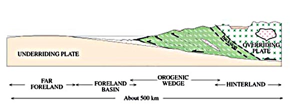
In geology, a nappe or thrust sheet is a large sheetlike body of rock that has been moved more than or above a thrust fault from its original position. Nappes form in compressional tectonic settings like continental collision zones or on the overriding plate in active subduction zones. Nappes form when a mass of rock is forced (or "thrust") over another rock mass, typically on a low angle fault plane. The resulting structure may include large-scale recumbent folds, shearing along the fault plane,Twiss, Robert J. and Eldridge M. Moores, ''Structural Geology,'' W. H. Freeman, 1992, p. 236 imbricate thrust stacks, fensters and klippes. The term stems from the French word for '' tablecloth'' in allusion to a rumpled tablecloth being pushed across a table. History Nappes or nappe belts are a major feature of the European Alps, Dinarides, Carpathians and Balkans. Since the 19th century many geologists have uncovered areas with large-scale overthrusts. Some of these were s ... [...More Info...] [...Related Items...] OR: [Wikipedia] [Google] [Baidu] |
Lechquellen Mountains
The Lechquellen Mountains (german: Lechquellengebirge) or Lechquellen range is a small mountain group within the Northern Limestone Alps of the Eastern Alps. It lies entirely within the Austrian state of Vorarlberg and includes the upper reaches of the river Lech with its headstreams in a horseshoe shape as well as the Upper Großwalsertal valley. Origin of the name The name ''Lechquellengebirge'' (literally "Lech source mountains") is certainly accurate, for the greater part of the mountain range surrounds the upper reaches of the Lech with its two spring-fed streams, the Formarinbach and the Spullerbach. Nevertheless, it is in fact an artificial name made up by Walther Flaig at a time when the development of mountaineering in the Alps had been largely completed. Previously, the mountain range had been called either the Klostertal Alps or counted as part of the Lechtal Alps east of the Flexen Pass. Artificial names often find it hard to establish themselves in everyday ... [...More Info...] [...Related Items...] OR: [Wikipedia] [Google] [Baidu] |


