|
Kailua Kona
Kailua-Kona is an Unincorporated area#United States, unincorporated community and census-designated place (CDP) in Hawaii County, Hawaii, Hawaii County, Hawaii, United States. It is most commonly referred to simply as Kona (a name it shares with Kona District, Hawaii, the district to which it belongs), but also as Kona Town, and occasionally as Kailua (a name it shares with Kailua, Honolulu County, Hawaii, a community on the windward side of Oahu, Oahu), thus its less frequent use. Kailua-Kona is the second-largest settlement on the Hawaii (island), island of Hawaii (after Hilo) and the largest on the island's west side, where it is the center of commerce and the tourist industry. Kailua-Kona is served by Kona International Airport, just to the north in the adjacent CDP of Kalaoa, Hawaii, Kalaoa. The population was 19,713 at the 2020 United States census, 2020 census, up from 11,975 at the 2010 United States Census, 2010 census. Kailua-Kona was the closest major settlement to th ... [...More Info...] [...Related Items...] OR: [Wikipedia] [Google] [Baidu] |
Kona International Airport
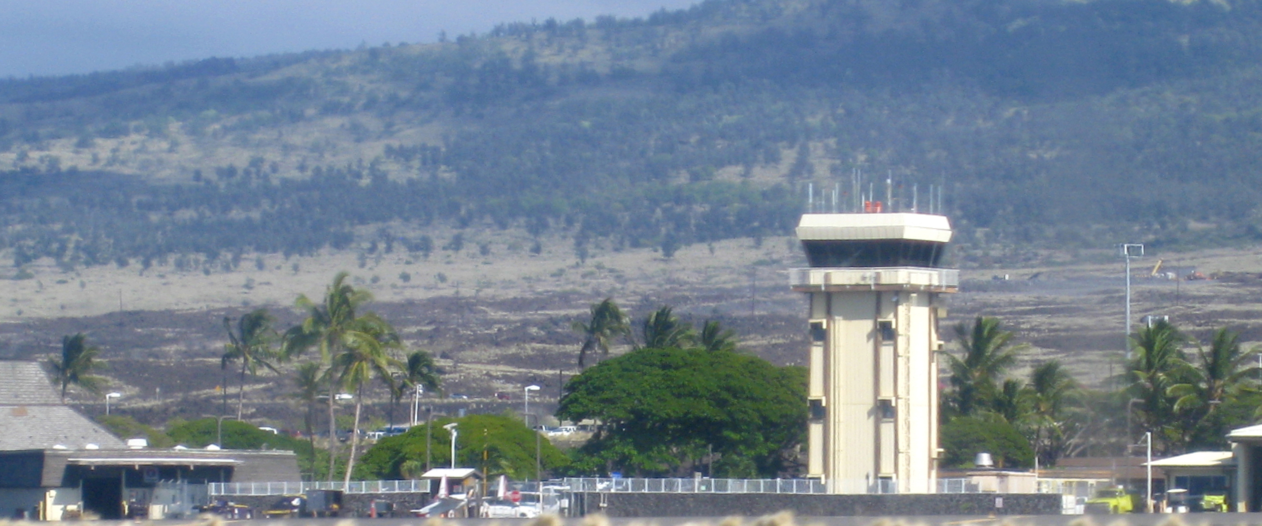
Ellison Onizuka Kona International Airport at Keāhole is the primary airport on the Hawaii (island), Island of Hawaiʻi, located in Kailua-Kona, Hawaii, Kailua-Kona, Hawaii, United States. The airport serves leeward (western) Hawaii (island), Hawaiʻi island, including the resorts in Kona District, Hawaii, North Kona and Kohala, Hawaii, South Kohala. It is one of two international airports serving Hawaiʻi island, the other being Hilo International Airport on the windward (eastern) side. It is included in the Federal Aviation Administration's National Plan of Integrated Airport Systems for 2021–2025, in which it is FAA airport categories, categorized as a small-hub primary commercial service facility. History Construction Much of the runway is built on a relatively recent lava flow: the 1801 ''Huʻehuʻe'' flow from Hualālai. This flow extended the shoreline out an estimated , adding some of land to the island and creating Keahole Point, Keāhole Point. The airport ... [...More Info...] [...Related Items...] OR: [Wikipedia] [Google] [Baidu] |
Census Designated Place
A census-designated place (CDP) is a Place (United States Census Bureau), concentration of population defined by the United States Census Bureau for statistical purposes only. CDPs have been used in each decennial census since 1980 as the counterparts of incorporated places, such as self-governing city (United States), cities, town (United States), towns, and village (United States), villages, for the purposes of gathering and correlating statistical data. CDPs are populated areas that generally include one officially designated but currently unincorporated area, unincorporated community, for which the CDP is named, plus surrounding inhabited countryside of varying dimensions and, occasionally, other, smaller unincorporated communities as well. CDPs include small rural communities, Edge city, edge cities, colonia (United States), colonias located along the Mexico–United States border, and unincorporated resort and retirement community, retirement communities and their environs. ... [...More Info...] [...Related Items...] OR: [Wikipedia] [Google] [Baidu] |
Hilo
Hilo () is the largest settlement in and the county seat of Hawaii County, Hawaiʻi, United States, which encompasses the Island of Hawaiʻi, and is a census-designated place (CDP). The population was 44,186 according to the 2020 census. It is the fourth-largest settlement in the state of Hawaiʻi, the largest settlement in the state outside of Oahu, and the largest settlement in the state outside of the Greater Honolulu Area. Hilo is in the District of South Hilo. The city overlooks Hilo Bay and has views of two shield volcanoes, Mauna Loa, an active volcano, and Mauna Kea, a dormant volcano. The Hilo bayfront has been destroyed by tsunamis twice. The majority of human settlement in Hilo stretches from Hilo Bay to Waiākea-Uka, on the flanks of the volcanoes. Hilo is home to the University of Hawaii at Hilo, ʻImiloa Astronomy Center, as well as the Merrie Monarch Festival, a week-long celebration, including three nights of competition, of ancient and modern hula that ... [...More Info...] [...Related Items...] OR: [Wikipedia] [Google] [Baidu] |
Kaloko-Honokōhau National Historical Park
Kaloko-Honokōhau National Historical Park is a United States National Historical Park located in the Kona District on Hawaiʻi Island in the U.S. state of Hawaii. It includes the National Historic Landmarked archaeological site known as the Honokōhau Settlement. The park was established on November 10, 1978, for the preservation, protection and interpretation of traditional native Hawaiian activities and culture. History and are the names of two of the four different '' '', or traditional mountain-to-sea land divisions encompassed by the park. Although in ancient times this arid area of lava rock was called (lands without water), the abundant sea life attracted settlement for hundreds of years. Kaloko (meaning "the pond" in the Hawaiian language) is a site of fishponds used in ancient Hawaiʻi is on the north end of the park. The first reference to the pond comes from the story of Kamalalawalu, about 300 years ago. The (seawall) is over wide and high, stretch ... [...More Info...] [...Related Items...] OR: [Wikipedia] [Google] [Baidu] |
Ancient Hawaiian Aquaculture
Before contact with Europeans, the Hawaiian people practiced aquaculture through development of fish ponds (), the most advanced fish-husbandry among the original peoples of the Pacific. While other cultures in places like Egypt and China also used the practice, Hawaii's aquaculture was very advanced considering the much smaller size of the area of Hawaii compared to other aquacultural societies. Hawaiian fishponds were typically shallow areas of a reef flat surrounded by a low lava rock wall () built out from the shore. Several species of edible fish (such as mullet) thrive in such ponds, and Hawaiians developed methods to make them easy to catch. The Hawaiian fishpond was primarily a grazing area in which the fishpond-keeper cultivated algae; much in the way cattle ranchers cultivate grass for their cattle. The porous lava walls let in seawater (or sometimes fresh or brackish water, as in the case of the "Menehune" fishpond near Līhue, Kauai), but prevent the fish from esc ... [...More Info...] [...Related Items...] OR: [Wikipedia] [Google] [Baidu] |
Honolulu
Honolulu ( ; ) is the List of capitals in the United States, capital and most populous city of the U.S. state of Hawaii, located in the Pacific Ocean. It is the county seat of the Consolidated city-county, consolidated City and County of Honolulu County, Hawaii, Honolulu, situated along the southeast coast of the island of Oahu, Oʻahu, and is the westernmost and southernmost major U.S. city as well as westernmost and southernmost U.S. state capital. It is also a major hub for business, finance, hospitality, and military defense in both the state and Oceania. The city is characterized by a mix of various Asian culture, Asian, Western culture, Western, and Oceanian culture, Pacific cultures, reflected in its diverse demography, cuisine, and traditions. is Hawaiian language, Hawaiian for "sheltered harbor" or "calm port"; its old name, , roughly encompasses the area from Nuʻuanu Avenue to Alakea Street and from Hotel Street to Queen Street, which is the heart of the present dow ... [...More Info...] [...Related Items...] OR: [Wikipedia] [Google] [Baidu] |
Lāhainā, Hawai'i
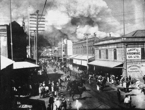
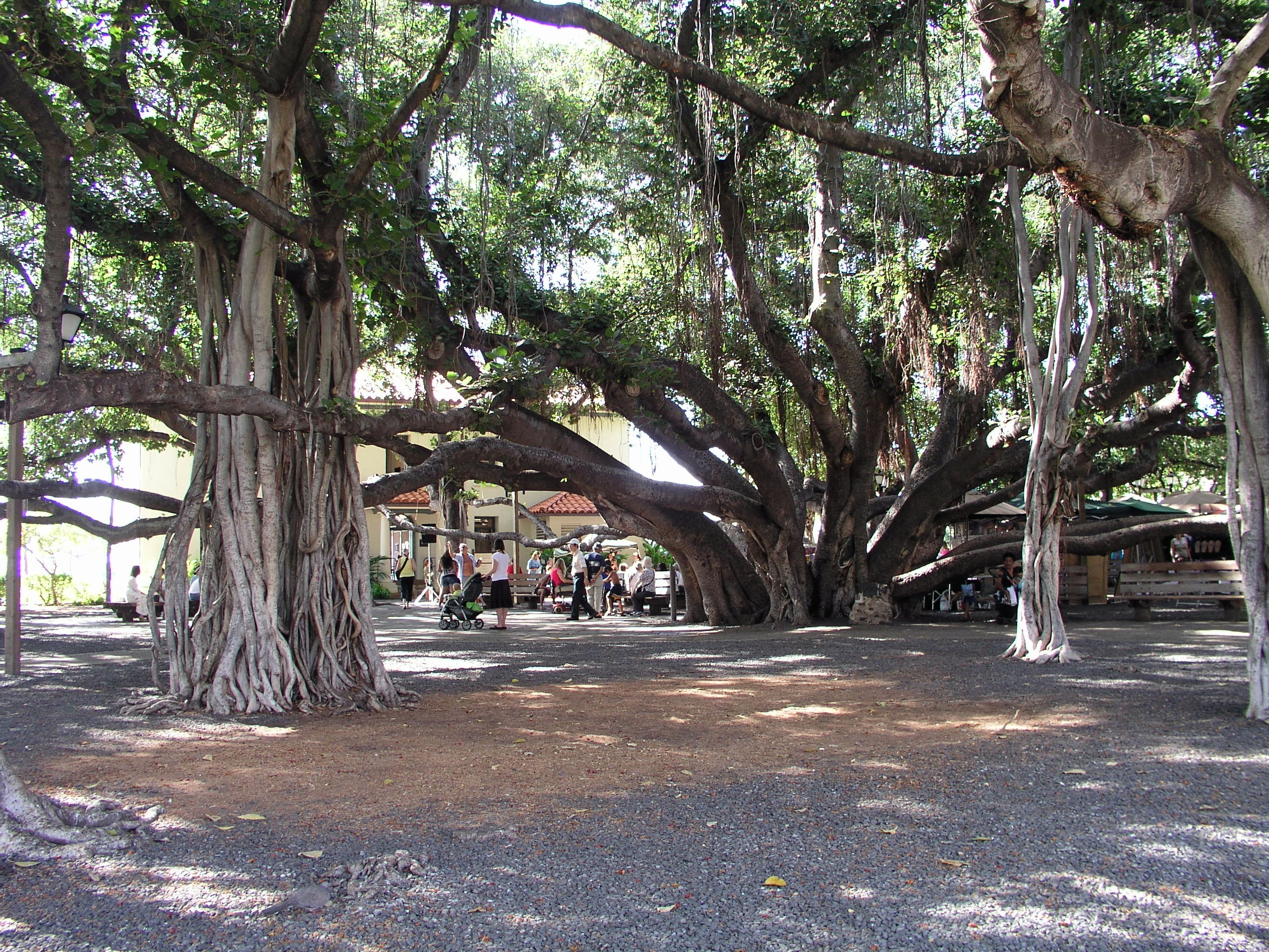
Lahaina (; ) or Lāhainā is a census-designated place (CDP) in Maui County, Hawaii, United States. On the northwest coast of the island of Maui, it encompasses Lahaina town and the Kaanapali and Kapalua beach resorts. At the 2020 census (before the 2023 wildfire), Lahaina had a resident population of 12,702. The CDP spans the coast along Hawaii Route 30 from a tunnel at the south end, through Olowalu, and to the CDPs of Kaanapali and Napili-Honokowai to the north. A series of wildfires destroyed approximately 80% of Lahaina in 2023, resulting in the deaths of 102 people. History Name Both ''Lahaina'' and ''Lāhainā'' are correct orthography in modern Hawaiian Modern name, etymology and pronunciations Protestant missionaries sent by the American Board of Commissioners for Foreign Missions (ABCFM) began organizing a way to write the Hawaiian language with English letters between 1820–1826 after they reached Hawaii. According to ''Thrums Hawaiian Annual'' o ... [...More Info...] [...Related Items...] OR: [Wikipedia] [Google] [Baidu] |
Kingdom Of Hawaii
The Hawaiian Kingdom, also known as the Kingdom of Hawaiʻi (Hawaiian language, Hawaiian: [kɛ ɐwˈpuni həˈvɐjʔi]), was an Archipelagic state, archipelagic country from 1795 to 1893, which eventually encompassed all of the inhabited Hawaiian Islands. It was established in 1795 when Kamehameha I, then Aliʻi nui of Hawaii, conquered the islands of Oʻahu, Maui, Molokaʻi, and Lānaʻi, and unified them under one government. In 1810, the Hawaiian Islands were fully unified when the islands of Kauaʻi and Niʻihau voluntarily joined the Hawaiian Kingdom. Two major Dynasty, dynastic families ruled the kingdom, the House of Kamehameha and the House of Kalākaua. The kingdom subsequently gained diplomatic recognition from European powers and the United States. An influx of European and American explorers, traders, and whalers soon began arriving to the kingdom, introducing diseases such as syphilis, tuberculosis, smallpox, and measles, leading to the rapid decline of the Native H ... [...More Info...] [...Related Items...] OR: [Wikipedia] [Google] [Baidu] |
Kamehameha I
Kamehameha I (; Kalani Paiʻea Wohi o Kaleikini Kealiʻikui Kamehameha o ʻIolani i Kaiwikapu kauʻi Ka Liholiho Kūnuiākea; to May 8 or 14, 1819), also known as Kamehameha the Great, was the conqueror and first ruler of the Kingdom of Hawaii. The state of Hawaii gave a statue of him to the National Statuary Hall Collection in Washington, D.C., as one of two statues it is entitled to install there. Birth and childhood Paternity and family history Kamehameha (known as Paiʻea at birth), was born to Kekuʻiapoiwa II, the niece of Alapainui, the usurping ruler of Hawaii Island who had killed the two legitimate heirs of Keaweʻīkekahialiʻiokamoku during civil war. By most accounts he was born in Ainakea, Kohala, Hawaii. His father was Keōua Kalanikupuapa'ikalaninui; however, Native Hawaiian historian Samuel Kamakau says that Maui monarch Kahekili II had ''hānai'' adopted (traditional, informal adoption) Kamehameha at birth, as was the custom of the time. Kamakau beli ... [...More Info...] [...Related Items...] OR: [Wikipedia] [Google] [Baidu] |
2006 Kiholo Bay Earthquake
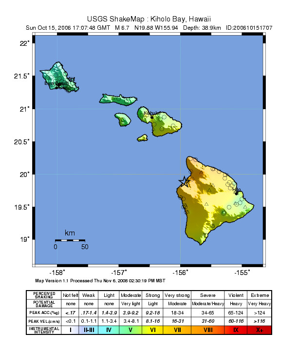
The 2006 Kīholo Bay earthquake occurred on October 15 at with a magnitude of 6.7 and a maximum Mercalli intensity of VIII (''Severe''). The shock was centered southwest of Puakō and north of Kailua-Kona, Hawaii, just offshore of the Kona Airport, at a depth of . It produced several aftershocks, including one that measured a magnitude of 6.1 seven minutes after the main shock. The Pacific Tsunami Warning Center measured a nondestructive tsunami of on the coast of the Big Island. Tectonic setting The island of Hawaii is affected by earthquakes related to three main causes. Some are associated with the movement of magma and tend to be shallow focus (less than depth). The largest earthquakes are those caused by overall gravitational spreading of the volcano, whether within the volcano's flanks or at the base of the volcanic pile. They tend to have focal depths in the range . The final group of earthquakes are those caused by flexure of the oceanic lithosphere underlying ... [...More Info...] [...Related Items...] OR: [Wikipedia] [Google] [Baidu] |


