|
Kaidō
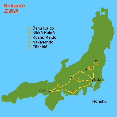
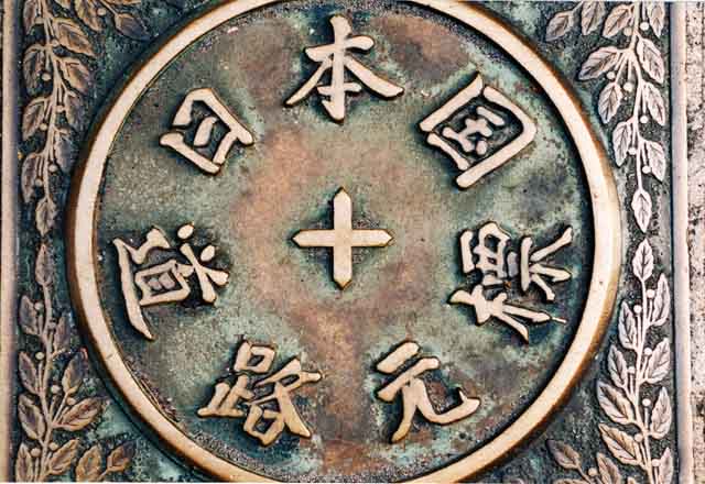
were roads in Japan dating from the Edo period. They played important roles in transportation like the Appian Way of ancient Roman roads. Major examples include the Edo Five Routes, all of which started at Edo (modern-day Tokyo). Minor examples include sub-routes such as the Hokuriku Kaidō and the Nagasaki Kaidō. ''Kaidō'', however, do ''not'' include San'yōdō, San'indō, Nankaidō and Saikaidō, which were part of the even more ancient system of Yamato government called Gokishichidō. These names were used for administrative units, and the roads within these units. Many highways and railway lines in modern Japan follow the ancient routes and carry the same names. The early roads radiated from the capital at Nara or Kyoto. Later, Edo was the reference, and even today Japan reckons directions and measures distances along its highways from Nihonbashi in Chūō, Tokyo. Gokaidō The five main ''kaidō'' from Nihonbashi in Edo were: * Tōkaidō (東海道) to Kyot ... [...More Info...] [...Related Items...] OR: [Wikipedia] [Google] [Baidu] |
Edo Five Routes
The , sometimes translated as "Five Highways", were the five centrally administered routes, or '' kaidō'', that connected the ''de facto'' capital of Japan at Edo (now Tokyo) with the outer provinces during the Edo period (1603–1868). The most important of the routes was the Tōkaidō, which linked Edo and Kyoto. Tokugawa Ieyasu started the construction of these five routes to increase his control over the country in 1601, but it was Tokugawa Ietsuna, the 4th ''shōgun'' of the Tokugawa shogunate and Ieyasu's great-grandson, who declared them as major routes. Post stations were set up along the route for travelers to rest and buy supplies. The routes thrived due to the policy of ''sankin-kōtai'', that required the ''daimyō'' (regional rulers) to travel in alternate years along the routes to Edo. History The various roads that make up the Five Routes existed in some form before becoming an official set of routes. Tokugawa Ieyasu began work on the routes shortly after bec ... [...More Info...] [...Related Items...] OR: [Wikipedia] [Google] [Baidu] |
Ōshū Kaidō
The was one of the five routes of the Edo period. It was built to connect Edo (modern-day Tokyo) with Mutsu Province and the present-day city of Shirakawa, Fukushima Prefecture, Japan. It was established by Tokugawa Ieyasu for government officials traveling through the area. Subroutes In addition to the established use of traveling from Edo to Mutsu Province, there were also many roads that connected from the Ōshū Kaidō. One such sub-route was the Sendaidō (仙台道), which connected Mutsu Province with Sendai. The terminus for the Sendaidō is in Aoba-ku in modern Sendai. From there, the Matsumaedō (松前道) connected Sendai with Hakodate, Hokkaidō. Though the Ōshū Kaidō has only 27 post stations,Ōshū Kaidō Map Yumekaidō. Accessed September 4, 2007. there were over 100 designated post stations when the subro ... [...More Info...] [...Related Items...] OR: [Wikipedia] [Google] [Baidu] |
Kōshū Kaidō
The was one of the five routes of the Edo period. It was built to connect Edo (modern-day Tokyo) with Kai Province in modern-day Yamanashi Prefecture, Japan. The route continues from there to connect with the Nakasendō's Shimosuwa-shuku in Nagano Prefecture.Information on Everyday Living for Foreign Residents of Shinjuku City . Shinjuku City Office. Accessed November 28, 2007. Many feudal lords from made use of the road during '''', including those from the [...More Info...] [...Related Items...] OR: [Wikipedia] [Google] [Baidu] |
Nikkō Kaidō
The was one of the five routes of the Edo period and it was built to connect Edo (modern-day Tokyo) with the temple-shrine complex of the Mangan-ji and Tōshōsha (now called the Rinnō-ji and Tōshōgū), which are located in the present-day city of Nikkō, Tochigi Prefecture, Japan. It was an ancient path that became formalised when power moved to Edo, and was established fully in 1617 by Tokugawa Hidetada, to give safer access to the temple-shrine mausoleum of his father, the first shogun Tokugawa Ieyasu, who was buried there that year.Nikkōdō . Accessed August 15, 2007. With only twenty-one stations, the Nikkō Kaidō was the shortest of the five routes, and it shares seventeen stations with the . Its ... [...More Info...] [...Related Items...] OR: [Wikipedia] [Google] [Baidu] |
Shukuba
were post stations during the Edo period in Japan, generally located on one of the Edo Five Routes or one of its sub-routes. They were also called ''shuku-eki'' (宿駅). These post stations (or "post towns") were places where travelers could rest on their journey around the nation. They were created based on policies for the transportation of goods by horseback that were developed during the Nara and Heian periods. History These post stations were first established by Tokugawa Ieyasu shortly after the end of the Battle of Sekigahara. The first post stations were developed along the Tōkaidō (followed by stations on the Nakasendō and other routes). In 1601, the first of the Tōkaidō's fifty-three stations were developed, stretching from Shinagawa-juku in Edo to Ōtsu-juku in Ōmi Province. Not all the post stations were built at the same time, however, as the last one was built in 1624. The lodgings in the post stations were established for use by public officials an ... [...More Info...] [...Related Items...] OR: [Wikipedia] [Google] [Baidu] |
Nagasaki Kaidō
The was a road across Kyūshū from Kokura to Nagasaki, used by ''daimyōs'' for the ''sankin-kōtai'', and also by the chief of the Dutch trading post at Nagasaki on whom a similar obligation of visiting the ''shōgun'' was imposed. The route stretched 228 km and took travelers approximately one week.Nagasaki Kaidō . Nagasaki Prefecture. Accessed March 12, 2008. Stations of the Nagasaki Kaidō The Nagasaki Kaidō's 25 post stations, as listed in 1705, are listed below with their modern-day municipalities indicated beside them. Travelers visiting Naruse-shuku and Shiota-shuku would avoid Kitagata-shuku and Tsukasaki-shuku.Fukuoka Prefecture :Starting Location: Tokiwabashi (常盤橋) ([...More Info...] [...Related Items...] OR: [Wikipedia] [Google] [Baidu] |
Tōkaidō (road)
The , which roughly means "eastern sea route," was the most important of the Five Routes of the Edo period in Japan, connecting Kyoto to Edo (modern-day Tokyo). Unlike the inland and less heavily travelled Nakasendō, the Tōkaidō travelled along the sea coast of eastern Honshū, hence the route's name. Traveling the Tōkaidō The standard method of travel was on foot, as wheeled carts were almost nonexistent and heavy cargo was usually sent by boat. Members of the higher class, however, travelled by '' kago''. Women were forbidden to travel alone and had to be accompanied by men. Other restrictions were also put in place for travellers, but, while severe penalties existed for various travel regulations, most seem not to have been enforced. Captain Sherard Osborn, who travelled part of the road in around 1858, noted that: Along the Tōkaidō, there were government-sanctioned post stations (shukuba) for travellers' rest. These stations consisted of porter stations and hors ... [...More Info...] [...Related Items...] OR: [Wikipedia] [Google] [Baidu] |
Nihonbashi
is a business district of Chūō, Tokyo, Japan which grew up around the bridge of the same name which has linked two sides of the Nihonbashi River at this site since the 17th century. The first wooden bridge was completed in 1603. The current bridge, designed by Tsumaki Yorinaka and constructed of stone on a steel frame, dates from 1911. The district covers a large area to the north and east of the bridge, reaching Akihabara to the north and the Sumida River to the east. Ōtemachi is to the west and Yaesu and Kyobashi to the south. Nihonbashi, together with Kyobashi and Kanda, is the core of Shitamachi, the original downtown center of Edo-Tokyo, before the rise of newer secondary centers such as Shinjuku and Shibuya. History The Nihonbashi district was a major mercantile center during the Edo period: its early development is largely credited to the Mitsui family, who based their wholesaling business in Nihonbashi and developed Japan's first department store, ... [...More Info...] [...Related Items...] OR: [Wikipedia] [Google] [Baidu] |
Nakasendō
The , also called the ,Richard Lane, ''Images from the Floating World'' (1978) Chartwell, Secaucus ; pg. 285 was one of the five routes of the Edo period, and one of the two that connected Edo (modern-day Tokyo) to Kyoto in Japan. There were 69 stations (staging-posts) between Edo and Kyoto, crossing through Musashi, Kōzuke, Shinano, Mino and Ōmi provinces.Nakasendou Jouhou . NEC Corporation. Retrieved August 18, 2007. In addition to Tokyo and Kyoto, the Nakasendō runs through the modern-day prefectures of Saitama, Gunma, Nagano [...More Info...] [...Related Items...] OR: [Wikipedia] [Google] [Baidu] |
Japan
Japan ( ja, 日本, or , and formally , ''Nihonkoku'') is an island country in East Asia. It is situated in the northwest Pacific Ocean, and is bordered on the west by the Sea of Japan, while extending from the Sea of Okhotsk in the north toward the East China Sea, Philippine Sea, and Taiwan in the south. Japan is a part of the Ring of Fire, and spans an archipelago of 6852 islands covering ; the five main islands are Hokkaido, Honshu (the "mainland"), Shikoku, Kyushu, and Okinawa. Tokyo is the nation's capital and largest city, followed by Yokohama, Osaka, Nagoya, Sapporo, Fukuoka, Kobe, and Kyoto. Japan is the eleventh most populous country in the world, as well as one of the most densely populated and urbanized. About three-fourths of the country's terrain is mountainous, concentrating its population of 123.2 million on narrow coastal plains. Japan is divided into 47 administrative prefectures and eight traditional regions. The Greater Tokyo Ar ... [...More Info...] [...Related Items...] OR: [Wikipedia] [Google] [Baidu] |
Shirakawa, Fukushima
270px, Nanko Park in Shirakawa is a city located in Fukushima Prefecture, Japan. , the city had an estimated population of 59,393 in 23,546 households and a population density of 190 persons per km2. The total area of the city was . Geography Shirakawa is located in south-central Fukushima prefecture facing the Nasu plateau, and extending to the lowland Shirakawa Basin. *Rivers: Abukuma River Neighboring municipalities * Fukushima Prefecture ** Nishigō ** Izumizaki ** Nakajima ** Yabuki ** Tanagura ** Ishikawa ** Asakawa ** Ten'ei *Tochigi Prefecture ** Nasu Climate Shirakawa has a humid continental climate (Köppen ''Cfa'') characterized by mild summers and cold winters. The average annual temperature in Shirakawa is 11.4 °C. The average annual rainfall is 1377 mm with September as the wettest month. The temperatures are highest on average in August, at around 25.0 °C, and lowest in January, at around 0.3 °C. Demographics History Th ... [...More Info...] [...Related Items...] OR: [Wikipedia] [Google] [Baidu] |
Kyoto
Kyoto (; Japanese: , ''Kyōto'' ), officially , is the capital city of Kyoto Prefecture in Japan. Located in the Kansai region on the island of Honshu, Kyoto forms a part of the Keihanshin metropolitan area along with Osaka and Kobe. , the city had a population of 1.46 million. The city is the cultural anchor of a substantially larger metropolitan area known as Greater Kyoto, a metropolitan statistical area (MSA) home to a census-estimated 3.8 million people. Kyoto is one of the oldest municipalities in Japan, having been chosen in 794 as the new seat of Japan's imperial court by Emperor Kanmu. The original city, named Heian-kyō, was arranged in accordance with traditional Chinese feng shui following the model of the ancient Chinese capital of Chang'an/ Luoyang. The emperors of Japan ruled from Kyoto in the following eleven centuries until 1869. It was the scene of several key events of the Muromachi period, Sengoku period, and the Boshin War, such as the Ōnin War, ... [...More Info...] [...Related Items...] OR: [Wikipedia] [Google] [Baidu] |


.jpg)


