|
Kai Tak
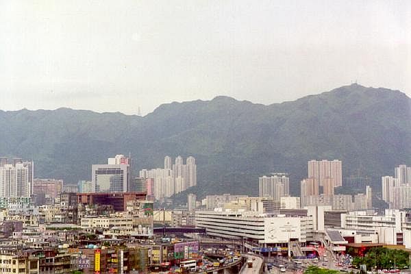
The Kai Tak Development (), abbreviated as "KTD" and formerly called South East Kowloon Development (), refers to the redevelopment of the former Kai Tak Airport site in Kai Tak (constituency), Kai Tak, Kowloon, Hong Kong. After the airport relocated to Chek Lap Kok in 1998, the Hong Kong government planned for urban development on the old airport site. The plan calls for a multi-purpose sports complex, a metro park, the Kai Tak Cruise Terminal, a hotel, a housing estate, and commercial and entertainment construction projects over an area of more than . The plan also covered nearby development in areas including Ma Tau Wai, Kowloon City, San Po Kong, Kowloon Bay and Kwun Tong. The planned population is 86,000 people, accommodated in 30,000 housing units, including 13,000 constructed as part of Public housing in Hong Kong, public housing estates. The total gross floor area is over with over of open space. The total cost for the development is about HK$100 billion. After sever ... [...More Info...] [...Related Items...] OR: [Wikipedia] [Google] [Baidu] |
Kai Tak Cruise Terminal
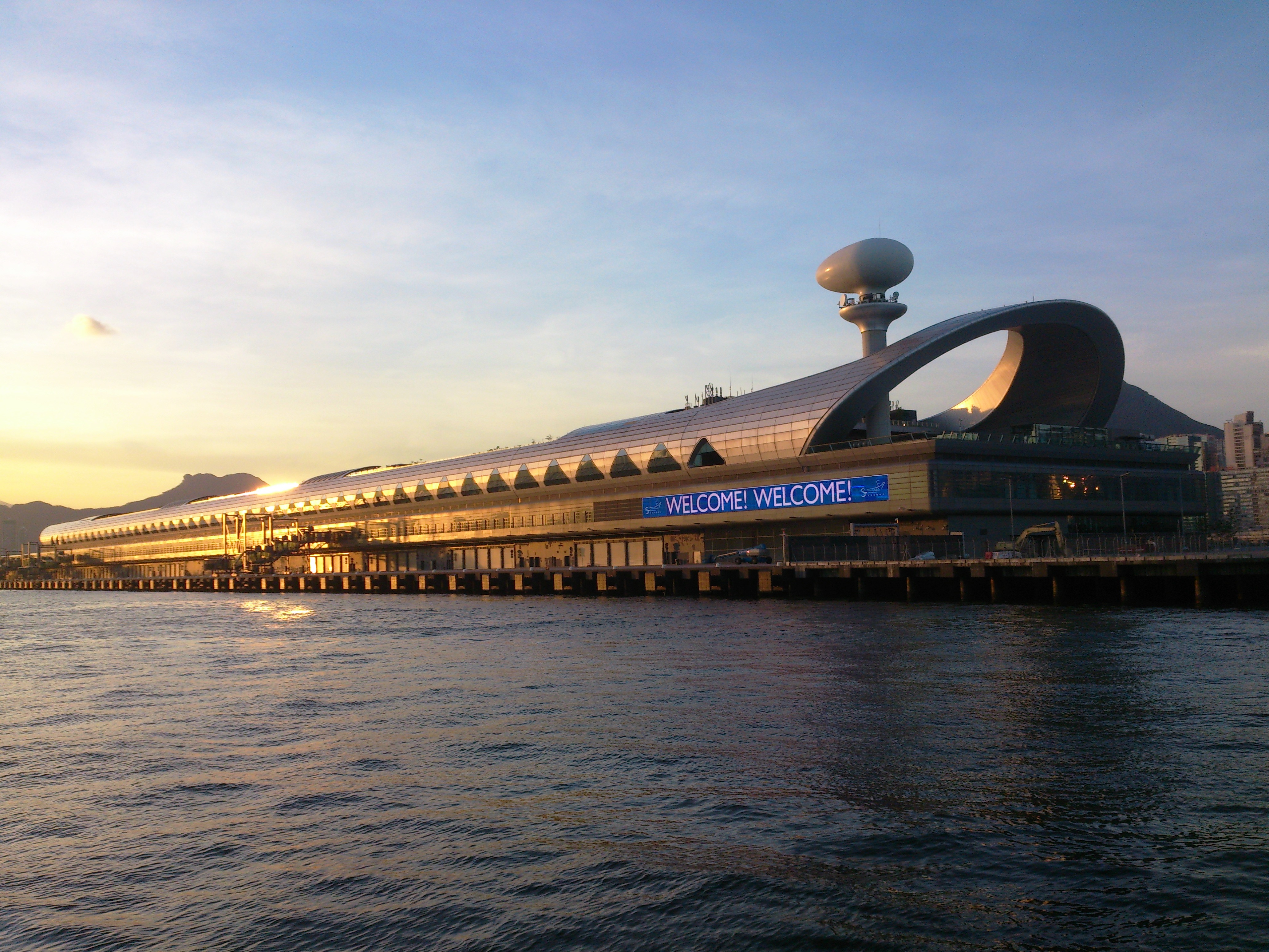
Kai Tak Cruise Terminal is a cruise ship terminal on the former Kai Tak Airport runway in Hong Kong. Its completion date was delayed into 2013 due to re-tendering. Following an international competition, Foster + Partners was chosen to design the cruise terminal. The first ship berthed on 12 June 2013. The terminal has the capacity to berth two large long vessels, which carry a total of 5,400 passengers and 1,200 crew, as well as anticipating the demands of cruise liners currently on the drawing board. The Government announced that it would focus on the development of a new cruise terminal at Kai Tak development area to help Hong Kong become a regional transport hub for cruise ships. It was built by Dragages Hong Kong Limited and site formation was completed by Penta-Ocean Construction Company. History and development The annual berth utilisation rate of Ocean Terminal in Tsim Sha Tsui, which offers two berths accommodating vessels of up to , rose to 76% last year f ... [...More Info...] [...Related Items...] OR: [Wikipedia] [Google] [Baidu] |
Kai Tak Airport
Kai Tak Airport was an international airport of Hong Kong from 1925 until 1998. Officially known as Hong Kong International Airport from 1954 to 6 July 1998, it is often referred to as Hong Kong International Airport, Kai Tak, or simply Kai Tak and Kai Tak International Airport, to distinguish it from its successor, Chek Lap Kok International Airport, built on reclaimed and levelled land around the islands of Chek Lap Kok and Lam Chau, to the west. Because of the geography of the area, with water on three sides of the runway, Kowloon City's residential apartment complexes to the north-west and mountains more than high to the north-east of the airport, aircraft could not fly over the mountains and quickly drop in for a final approach. Instead, aircraft had to fly above Victoria Harbour and Kowloon City, passing north of Mong Kok's Bishop Hill. After passing Bishop Hill, pilots would see Checkerboard Hill with a large orange-and-white checkerboard pattern. Once the pat ... [...More Info...] [...Related Items...] OR: [Wikipedia] [Google] [Baidu] |
Kai Tak
The Kai Tak Development (), abbreviated as "KTD" and formerly called South East Kowloon Development (), refers to the redevelopment of the former Kai Tak Airport site in Kai Tak (constituency), Kai Tak, Kowloon, Hong Kong. After the airport relocated to Chek Lap Kok in 1998, the Hong Kong government planned for urban development on the old airport site. The plan calls for a multi-purpose sports complex, a metro park, the Kai Tak Cruise Terminal, a hotel, a housing estate, and commercial and entertainment construction projects over an area of more than . The plan also covered nearby development in areas including Ma Tau Wai, Kowloon City, San Po Kong, Kowloon Bay and Kwun Tong. The planned population is 86,000 people, accommodated in 30,000 housing units, including 13,000 constructed as part of Public housing in Hong Kong, public housing estates. The total gross floor area is over with over of open space. The total cost for the development is about HK$100 billion. After sever ... [...More Info...] [...Related Items...] OR: [Wikipedia] [Google] [Baidu] |
Protection Of The Harbour Ordinance
The Protection of the Harbour Ordinance, Cap. 531 () is an ordinance in Hong Kong Law that aims to limit land reclamation in the surviving waters of Victoria Harbour. Content In section 3, the ordinance states that: *"The harbour is to be protected and preserved as a special public asset and a natural heritage of the Hong Kong people and, for that purpose, there shall be a presumption against reclamation in the harbour." *"All public officers and public bodies shall have regard to the principle stated in subsection (1) for guidance in the exercise of any powers vested in them." History The ordinance was proposed by the Society for Protection of the Harbour in 1996 and presented to the Legislative Council by Christine Loh. The bill was passed on 27 June 1997 and applied to the area of the harbour around Central, Hong Kong. On 3 November 1999, the Secretary for Planning, Environment and Lands moved for an amendment to the ordinance, which extended it to the entire area of Vict ... [...More Info...] [...Related Items...] OR: [Wikipedia] [Google] [Baidu] |
Wan Chai Development Phase II
WAN or Wan may refer to: Language * Wan language of the Ivory Coast * 万/萬 (Pinyin: Wàn), 10,000 in Chinese People * Wan (surname) ( and ), a Chinese surname * Wan (surname 溫), an alternative spelling for the Chinese surname Wen (溫) * Wan Wan (彎彎; born 1981) Taiwanese artist and actress * Wan (khan), Jurchen chieftain * ''Wan'', female Malay styles and titles Places Asia * Anhui, abbreviated Wǎn (皖), province of China * Nanyang, Henan, abbreviated Wǎn (宛), a city in China * Van, Turkey () * Wan, Pakistan, a village in Sialkot District, Punjab, Pakistan * Wan Man, an island in Terengganu, Malaysia Elsewhere * Wallan railway station, Australia * Wan, Burkina Faso, a town in Burkina Faso * Wanborough railway station, Surrey, England (GB station code: WAN) Other uses * Wataniya Airways, a former Kuwaiti airline, ICAO designator * Wide area network, computer network * WAN-IFRA, World Association of Newspapers The World Association of Newspapers and ... [...More Info...] [...Related Items...] OR: [Wikipedia] [Google] [Baidu] |
Society For Protection Of The Harbour
Society for Protection of the Harbour (SPH) () is a Hong-Kong-based organisation founded in November 1995. It is a charitable, non-political and non-profit making green group. The objectives of the organisation are to protect the Victoria Harbour in Hong Kong from destruction caused by Government's excessive reclamation and improper development, and to arouse public aspirations for the Harbour. To preserve the Harbour, SPH has raised a number of objections on related Government policies, undertaken numerous conservation projects, suggested constructive urban planning along the waterfront and carried out public education on harbour protection. References * Website of Society for Protection of the Harbour * Website of Friends of The Harbour http://www.friendsoftheharbour.org/ * ''Town Planning Board'': Planning for victoria Harbour http://www.info.gov.hk/tpb/ * ''South China Morning Post'' (南華早報) * ''The Standard'' (英文虎報) * ''Sing Tao Daily''(星島日報) * '' ... [...More Info...] [...Related Items...] OR: [Wikipedia] [Google] [Baidu] |
Tseung Kwan O
Tseung Kwan O New Town, commonly known as Tseung Kwan O ( zh, t=將軍澳新市鎮, j=Zoeng1 gwan1 ou3 san1 si5 zan3), is one of the nine New towns of Hong Kong, new towns in Hong Kong, built mainly on Land reclamation in Hong Kong, reclaimed land in the northern half of Junk Bay in southeastern New Territories, after which it is named. Development of the new town was approved in 1982, with the initial population intake occurring in 1988. As of 2016, the town is home to around 396,000 residents. The total development area of Tseung Kwan O, including its industrial estate, is about , with a planned population of 445,000. Major residential neighbourhoods within the new town include Tsui Lam Estate, Tsui Lam, Po Lam, Hang Hau, Tseung Kwan O Town Centre, Tiu Keng Leng (also known by its English name Rennie's Mill) and Siu Chik Sha, etc. Administratively, the new town belongs to Sai Kung District in southeastern New Territories, although it is often incorrectly regarded as part of ... [...More Info...] [...Related Items...] OR: [Wikipedia] [Google] [Baidu] |
Kwun Tong Bypass
The Kwun Tong Bypass (also spelt Kwun Tong By-pass) is an elevated Controlled-access highway, expressway between Lam Tin and Kowloon Bay in Kwun Tong District, East Kowloon, Kowloon East, Hong Kong, with three lanes in each direction and a posted speed limit of . It is part of Route 2 (Hong Kong), Route 2 and has links to Route 5 (Hong Kong), Route 5 and Route 7 (Hong Kong), Route 7. It Bypass route, bypasses the industrial township of Kwun Tong and passes next to the boundary of the Kai Tak Airport. Constructed mainly along the seaward frontage of Kwun Tong, Kwun Tong Business Area, the bypass was built to alleviate traffic congestion on Kwun Tong Road of Route 7, to which it is parallel. It bridges Eastern Harbour Crossing (Route 2) and Tseung Kwan O Tunnel (Route 7) at its southeastern end with Tate's Cairn Tunnel (Route 2) and Kai Tak Tunnel (Route 5) at its northwestern end, providing a fast connection across eastern New Kowloon. Route description The eastern terminus of ... [...More Info...] [...Related Items...] OR: [Wikipedia] [Google] [Baidu] |
Central Kowloon Route
The Central Kowloon Route (CKR) is a highway project under construction in Kowloon, Hong Kong. When completed in 2025, it will form the section of the planned Route 6 which runs through the Kowloon Peninsula, largely underground. The three-lane dual carriageway would begin at the Yau Ma Tei interchange of the West Kowloon Highway and finish at a new interchange in the Kai Tak Development. From there, Route 6 is planned to continue to Tseung Kwan O Tseung Kwan O New Town, commonly known as Tseung Kwan O ( zh, t=將軍澳新市鎮, j=Zoeng1 gwan1 ou3 san1 si5 zan3), is one of the nine New towns of Hong Kong, new towns in Hong Kong, built mainly on Land reclamation in Hong Kong, reclaimed ..., although the section beyond Kai Tak is not part of the CKR project. Between Yau Ma Tei and Kai Tak, there are no intermediate interchanges. The proposed alignment will lead to the demolition of numerous structures including the Yau Ma Tei Car Park Building, a public library, the jade ... [...More Info...] [...Related Items...] OR: [Wikipedia] [Google] [Baidu] |


