|
Jalamah
Jalamah () or Jalameh is a Palestinian village in the West Bank, located 5 km north of the city of Jenin in the northern West Bank. According to the Palestinian Central Bureau of Statistics, the town had a population of 2,304 inhabitants in mid-year 2006 and 2,268 in 2017. History It has been suggested that this was ''Jiliimna'' in the list of places conquered by Thutmose III. Ceramics from the Byzantine era have been found here. Ottoman era Jalamah, like the rest of Palestine, was incorporated into the Ottoman Empire in 1517. During the 16th and 17th centuries, Jalama belonged to the Turabay Emirate (1517-1683), which encompassed also the Jezreel Valley, Haifa, Jenin, Beit She'an Valley, northern Jabal Nablus, Bilad al-Ruha/Ramot Menashe, and the northern part of the Sharon plain. In the census of 1596, Jalama appeared as ''Jalama'', located in the ''nahiya'' of ''Sara'' in the '' liwa'' of Lajjun. It had a population of 16 households, all Muslim. They paid ... [...More Info...] [...Related Items...] OR: [Wikipedia] [Google] [Baidu] |
Jenin
Jenin ( ; , ) is a city in the West Bank, Palestine, and is the capital of the Jenin Governorate. It is a hub for the surrounding towns. Jenin came under Israeli occupied territories, Israeli occupation in 1967, and was put under the administration of the Palestinian National Authority as West Bank areas in the Oslo II Accord, Area A of the West Bank, a Palestinian enclave, in 1995. The city had a population of approximately 50,000 people in 2017, whilst the Jenin Camp, Jenin refugee camp had a population of about 10,000, housing families of Palestinians who fled or were expelled from their homes during the 1948 Palestine war, 1948 Palestine War.2007 Locality Population Statistics . Palestinian Central Bureau of Statistics The camp has since become a stronghold of Palestinian political violence ... [...More Info...] [...Related Items...] OR: [Wikipedia] [Google] [Baidu] |
Jenin Governorate
The Jenin Governorate () is one of 16 Governorates of Palestine. It covers the northern extremity of the West Bank, including the area around the city of Jenin, which is the district capital or ''muhfaza'' of the district. According to the Palestinian Central Bureau of Statistics 2017 Census, the governorate had a population of 314,866. This is an increase from the reported population of 256,619 in the 2007 Census2007 Locality Population Statistics living in 47,437 households. 100,701 inhabitants (or 39%) were under the age of 63 (or 31%) were re ... [...More Info...] [...Related Items...] OR: [Wikipedia] [Google] [Baidu] |
Arabic Script
The Arabic script is the writing system used for Arabic (Arabic alphabet) and several other languages of Asia and Africa. It is the second-most widely used alphabetic writing system in the world (after the Latin script), the second-most widely used List of writing systems by adoption, writing system in the world by number of countries using it, and the third-most by number of users (after the Latin and Chinese characters, Chinese scripts). The script was first used to write texts in Arabic, most notably the Quran, the holy book of Islam. With Spread of Islam, the religion's spread, it came to be used as the primary script for many language families, leading to the addition of new letters and other symbols. Such languages still using it are Arabic language, Arabic, Persian language, Persian (Western Persian, Farsi and Dari), Urdu, Uyghur language, Uyghur, Kurdish languages, Kurdish, Pashto, Punjabi language, Punjabi (Shahmukhi), Sindhi language, Sindhi, South Azerbaijani, Azerb ... [...More Info...] [...Related Items...] OR: [Wikipedia] [Google] [Baidu] |
Turabay Dynasty
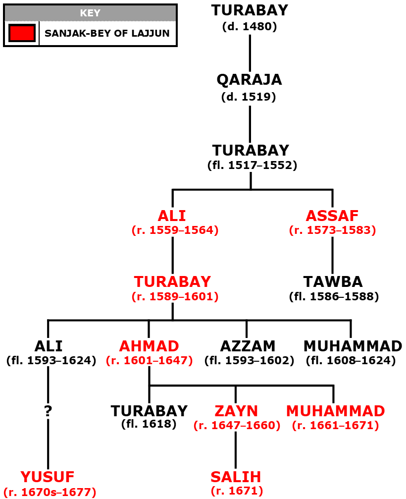
The Turabay dynasty () was a family of Bedouin emirs in northern Palestine (region), Palestine who served as the (tax farmers) and (district governors) of Lajjun Sanjak during Ottoman Empire, Ottoman rule in the 16th–17th centuries. The sanjak (district) spanned the towns of Lajjun, Jenin and Haifa, and the surrounding countryside. The progenitors of the family had served as chiefs of Jezreel Valley, Marj ibn Amir (the Plain of Esdraelon or Jezreel Valley) under the Egypt-based Mamluk Sultanate (Cairo), Mamluks in the late 15th century. During the Battle of Marj Dabiq, conquest of the Levant and Egypt by the Ottoman Empire in 1516–1517, the Turabay chief Qaraja and his son Turabay aided the forces of Ottoman Sultan Selim I. The Ottomans kept them in their Mamluk-era role as guardians of the strategic Via Maris and Damascus–Jerusalem highways and rewarded them with Farm (revenue leasing), tax farms in northern Palestine. Their territory became a sanjak in 1559 and Turabay' ... [...More Info...] [...Related Items...] OR: [Wikipedia] [Google] [Baidu] |
Akçe
The ''akçe'' or ''akça'' (anglicized as ''akche'', ''akcheh'' or ''aqcha''; ; , , in Europe known as '' asper'') was a silver coin mainly known for being the chief monetary unit of the Ottoman Empire. It was also used in other states including the Anatolian Beyliks, the Aq Qoyunlu, and the Crimean Khanate. The basic meaning of the word is "silver" or "silver money", deriving from the Turkish word () and the diminutive suffix . Three s were equal to one . One-hundred and twenty 's equalled one . Later after 1687 the ' became the main unit of account, replacing the . In 1843, the silver ' was joined by the gold lira in a bimetallic system. Its weight fluctuated; one source estimates it between 1.15 and 1.18 grams. The name ' originally referred to a silver coin but later the meaning changed and it became a synonym for money. The mint in Novo Brdo, a fortified mining town in the Serbian Despotate rich with gold and silver mines, began to strike ' in 1441 when it was captur ... [...More Info...] [...Related Items...] OR: [Wikipedia] [Google] [Baidu] |
Muslim
Muslims () are people who adhere to Islam, a Monotheism, monotheistic religion belonging to the Abrahamic religions, Abrahamic tradition. They consider the Quran, the foundational religious text of Islam, to be the verbatim word of the God in Abrahamic religions, God of Abraham (or ''Allah'') as it was revealed to Muhammad, the last Islamic prophet. Alongside the Quran, Muslims also believe in previous Islamic holy books, revelations, such as the Tawrat (Torah), the Zabur (Psalms), and the Injeel (Gospel). These earlier revelations are associated with Judaism and Christianity, which are regarded by Muslims as earlier versions of Islam. The majority of Muslims also follow the teachings and practices attributed to Muhammad (''sunnah'') as recorded in traditional accounts (hadith). With an estimated population of almost 2 billion followers, Muslims comprise around 26% of the world's total population. In descending order, the percentage of people who identify as Muslims on each ... [...More Info...] [...Related Items...] OR: [Wikipedia] [Google] [Baidu] |
Lajjun
Lajjun (, ''al-Lajjūn'') was a large Palestine (region), Palestinian Arab village located northwest of Jenin and south of the remains of the biblical city of Tel Megiddo, Megiddo. The Israeli kibbutz of Megiddo, Israel was built 600 metres north-east of the depopulated village on the hill called Dhahrat ed Dar from 1949. Named after an early Roman legion camp in Syria Palaestina province called "Legio", predating the village at that location, Lajjun's history of habitation spanned some 2,000 years. Under Abbasid rule it was the capital of a subdistrict, during Mamluk rule it served as an important station in the Postal history of Palestine, postal route, and during Ottoman Empire, Ottoman rule it was the capital of a district that bore its name. After the collapse of the Ottoman Empire towards the end of World War I, Lajjun and all of Palestine was placed under the administration of the Mandate for Palestine, British Mandate. The village was depopulated during the 1948 Arab� ... [...More Info...] [...Related Items...] OR: [Wikipedia] [Google] [Baidu] |
Liwa (Arabic)
Liwa (, , "ensign" or "banner") has developed various meanings in Arabic: *a banner, in all senses (flag, advertising banner, election publicity banner, etc.) *a district; see also: banner (administrative division) *a level of military unit with its own ensign, now used as the equivalent to brigade *an officer commanding a number of ''liwa'' units, now equivalent to a major general In Turkish, liva (, ''livâ'') was used interchangeably with ''sanjak'' to describe the secondary administrative divisions into which the provinces of the Ottoman Empire were divided. After the fall of the empire, the term was used in the Arab countries formerly under Ottoman rule. It was gradually replaced by other terms like ''qadaa'' and '' mintaqa'' and is now defunct. It is only used occasionally in Syria to refer to the Hatay Province, ceded by the French mandate of Syria to Turkey Turkey, officially the Republic of Türkiye, is a country mainly located in Anatolia in West Asia, with a ... [...More Info...] [...Related Items...] OR: [Wikipedia] [Google] [Baidu] |
Nahiya
A nāḥiyah ( , plural ''nawāḥī'' ), also nahiyeh, nahiya or nahia, is a regional or local type of administrative division that usually consists of a number of villages or sometimes smaller towns. In Tajikistan, it is a second-level division while in Syria, Iraq, Lebanon, Jordan, Xinjiang, and the former administrative divisions of the Ottoman Empire, Ottoman Empire, where it was also called a ''bucak (administrative unit), bucak'', it is a third-level or lower division. It can constitute a division of a ''qadaa'', ''mintaqah'' or other such district-type division and is sometimes translated as "subdistrict". Ottoman Empire The nahiye () was an administrative territorial entity of the Ottoman Empire, smaller than a . The head was a (governor) who was appointed by the Pasha. The was a subdivision of a Selçuk Akşin Somel. "Kazâ". ''The A to Z of the Ottoman Empire''. Volume 152 of A to Z Guides. Rowman & Littlefield, 2010. p. 151. and corresponded roughly to a city w ... [...More Info...] [...Related Items...] OR: [Wikipedia] [Google] [Baidu] |
Defter
A ''defter'' was a type of tax register and land cadastre in the Ottoman Empire. Etymology The term is derived from Greek , literally 'processed animal skin, leather, fur', meaning a book, having pages of goat parchment used along with papyrus as paper in Ancient Greece, borrowed into Arabic as '':'' , meaning a register or a notebook. Description The information collected could vary, but ''tahrir defterleri'' typically included details of villages, dwellings, household heads (adult males and widows), ethnicity/religion (because these could affect tax liabilities/exemptions), and land use. The defter-i hakâni was a land registry, also used for tax purposes. Each town had a defter and typically an officiator or someone in an administrative role to determine whether the information should be recorded. The officiator was usually some kind of learned man who had knowledge of state regulations. The defter was used to record family interactions such as marriage and inheritance. Th ... [...More Info...] [...Related Items...] OR: [Wikipedia] [Google] [Baidu] |
Manasseh Hills
The Manasseh Hills or hill country of Manasseh, directly derived from Hebrew: Menashe Heights (), called Bilad ar-Ruha in Arabic, meaning "Land of Winds", is a geographical region in northern Israel, located on the Carmel Range, between Mount Carmel and Mount Amir/Umm al-Fahm. Etymology The hill country of Manasseh or Manasseh hill country, sometimes fully capitalised, is named for its location within the allotment of the biblical Tribe of Manasseh, itself named after its biblical forefather, Manasseh or Manasses. History During the Ottoman Period, the Menashe Hills formed part of Turabay Emirate (1517-1683), which encompassed also the Jezreel Valley, Haifa, Jenin, Beit She'an Valley, Mount Carmel, northern Jabal Nablus, and the northern part of the Sharon plain. During the late Ottoman period, the largest dispersal in the Mannaseh Hills was of people from Egypt, with another significant group being those from Hebron (Khalilia). These migrants likely settled in the ar ... [...More Info...] [...Related Items...] OR: [Wikipedia] [Google] [Baidu] |


